PS Exam Binder
Ultra-condensed quick reference for the Principles & Practice of Surveying (NCEES). Optimized for printing (~24 pages).
7 Sections~24 pagesPrint Optimized
1. PS Exam Overview
Format, weights, and strategy
| Item | Detail |
|---|---|
| Exam | Principles & Practice of Surveying (NCEES) |
| Format | 100 multiple-choice questions |
| Duration | 7 hours to complete the exam, including tutorial and optional scheduled break |
| Delivery | Computer-based at Pearson VUE; closed-book with on-screen NCEES PS Reference Handbook |
| Passing | Pass/fail; cut score set by NCEES (no published numeric score) |
| References | On-screen NCEES PS Reference Handbook only — no personal materials |
| Content Area | Weight | Questions | Key Topics |
|---|---|---|---|
| 1. Legal Principles | ~22% | ~22 | Hierarchy of calls, BFP/recording acts, easements, riparian rights |
| 2. Professional Survey Practices | ~22% | ~22 | Boundary retracement, monumentation, evidence, witness/lost corners |
| 3. Standards & Specifications | ~22% | ~22 | BLM Manual, ALTA/NSPS, FGCS accuracy standards, ROS contents |
| 4. Business Practices | ~17% | ~17 | Ethics, professional conduct, expert witness, liability, records |
| 5. Areas of Practice | ~17% | ~17 | Subdivision platting, topographic, construction, GIS/photogrammetric oversight |
Time Management Strategy (PS, ~7h test time)
- 100 questions in ~420 minutes ≈ 4.2 minutes per question.
- Computer-based with one 50-minute scheduled break between halves.
- Use the searchable on-screen NCEES PS Reference Handbook — practice with it before exam day.
- Apply common-law principles only — do not rely on state-specific statutes.
- No penalty for guessing — never leave a question blank.
- Legal Principles + Professional Practices ≈ 44% of the exam — emphasize boundary law mastery.
NCEES PS Reference Handbook (key tabs)
Surveying conventions & symbolsCoordinate geometry (COGO)Horizontal & vertical curvesTraverse & least-squaresPhotogrammetry / LiDARDatums, projections, geoidState Plane (Lambert / TM)BLM PLSS — sections, restorationStatistics & error propagationBoundary law / hierarchy of calls
Available on-screen during the exam at NCEES Pearson VUE delivery; download the latest edition from ncees.org for study.
2. Key Formulas
Traverse, area, curves, GPS, errors
Traverse Computations
Latitude:
Departure:
Closure Error:
Precision Ratio:
Compass Rule (Lat):
Compass Rule (Dep):
Area Computations
Coordinate Method:
DMD Method:
Trapezoidal Rule:
(equal spacing h)
Simpson's 1/3:
(odd # ordinates)
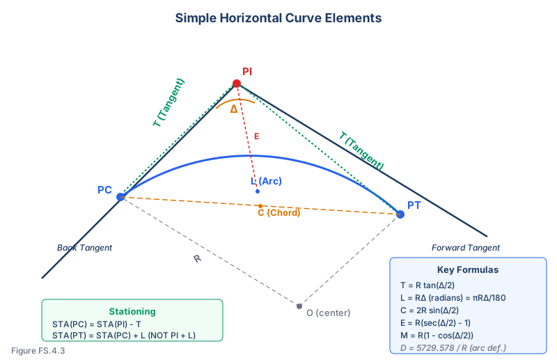
Horizontal Curves
Degree of Curve:
(arc definition)
Tangent:
Length:
(or 100 * Delta/D)
External:
Mid Ordinate:
Long Chord:
PC Station:
PT Station:
Vertical Curves
Rate of change:
(g in %, L in stations)
Elevation on curve:
High/low point:
(from BVC)
Offset from tangent:
(at midpoint; g in %, L in stations)
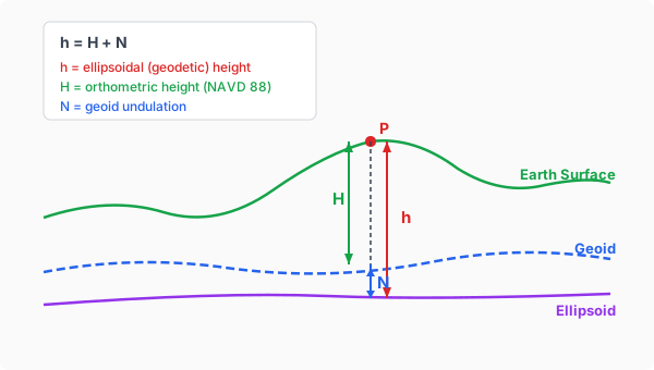
GPS Heights
Height relationship:
(ellipsoid = ortho + geoid)
Orthometric height:
Geoid undulation:
Scale / Grid-Ground Factors
Elevation factor:
(R = Earth radius, h = elevation)
Grid factor:
(varies with distance)
Combined factor:
Grid distance:
Error Theory & Statistics
Std deviation:
Std error of mean:
Error propagation (+/-):
Error propagation (*):
(Q = a*b)
Weighted mean:
(w = 1/sigma^2)
68-95-99.7 rule:
Photogrammetry
Photo scale:
(f = focal length, H = flying height)
Relief displacement:
(r = radial dist, h = obj height)
Flying height (AGL):
(for desired scale S)
Ground coverage:
3. Evidence Hierarchy & Boundary Rules
Common law hierarchy, retracement, unwritten rights
Hierarchy of Calls (Common Law / Brown's Ch. 5-6)
- Lines actually run on the ground - corners established, monuments set, lines marked by creating surveyor
- Natural monuments - rivers, lakes, ridges, trees
- Artificial monuments - stakes, pipes, stones set on ground
- Adjoiners / record boundaries - calls for adjoining tracts, senior rights
- Courses / bearings - direction of boundary lines
- Distances - measured lengths of lines
- Area / quantity - acreage or square footage (lowest weight)
Intent of the parties is the overriding principle governing all elements.
Evidence Hierarchy Pyramid
7 bands: top = Lines Actually Run (highest), bottom = Area (lowest)
| Monument Type | Examples | Relative Weight |
|---|---|---|
| Natural | Rivers, lakes, trees, ridges, rock outcrops | Highest |
| Artificial (original) | Original stakes, stones, mounds set by surveyor | High |
| Artificial (subsequent) | Iron pipes, rebar, mag nails set later | Medium-High |
| Record | Calls to adjoining tracts, recorded plats | Medium |
| Accessory/witness | Bearing trees, reference marks | Support only |
7 Rules of Construction
- Intent of the parties controls
- The deed is construed most strongly against the grantor
- A grant is always construed in favor of the grantee
- The whole instrument is considered, not isolated parts
- Specific descriptions prevail over general ones
- Where two clauses are irreconcilable, the LATER clause typically prevails (majority rule); a few states (notably CA) follow the opposite "first-clause" rule
- Monuments prevail over courses, courses over distances, distances over area
Retracement Principles
- Follow the footsteps of the original surveyor
- The retracing surveyor has NO authority to establish new corners
- Original monuments, when found, are conclusive (even if imprecise)
- Proportionate measurement used when original corners are lost
- An obliterated corner can be restored from evidence; a lost corner cannot
- Obliterated = position can be determined from evidence
- Lost = position cannot be determined beyond reasonable doubt
| Unwritten Right | Key Requirements | Time Period |
|---|---|---|
| Adverse Possession | Open, notorious, continuous, hostile, exclusive, under claim of right (tax payment is required only in a minority of states, e.g., CA) | Varies by state (10–20 yrs typical) |
| Prescriptive Easement | Open, notorious, continuous, hostile use (NO tax payment needed, NO exclusivity needed) | Varies by state (10–20 yrs typical) |
| Agreed Boundary | Uncertainty + agreement (express or implied) + acquiescence + change in position | No fixed period |
| Boundary by Acquiescence | Occupation to visible line with implied agreement | Statute of limitations |
| Boundary by Estoppel | Representation + reliance + injury if boundary changed | No fixed period |
| Practical Location | Acts on the ground showing where parties treated boundary | Long period of time |
Water Boundary Rules
- Accretion - Gradual, imperceptible additions of land by water action; boundary moves with water
- Reliction - Gradual recession of water; exposed land goes to riparian owner
- Avulsion - Sudden, perceptible change; boundary remains at original location
- Erosion - Gradual wearing away; boundary moves with the water
- Navigable waters: public trust doctrine applies (state owns bed below ordinary high water)
- Non-navigable: riparian owner typically owns to thread (center) of stream
5. Legal Descriptions
Types, parts, rules, key terms
| Type | Description | When Used |
|---|---|---|
| Metes & Bounds | Sequential bearings, distances, and curves from POB around perimeter | Irregular parcels, most boundary surveys |
| Lot & Block | Reference to recorded subdivision map (Lot X, Block Y, Tract Z) | Subdivided land, most common in urban areas |
| PLSS / Aliquot | Section, township, range (e.g., NW 1/4 of Sec. 12, T3N, R5W) | Federal lands, rural areas |
| Coordinate | Defined by state plane or other coordinates at each corner | Large tracts, government surveys |
Parts of a Metes & Bounds Description (in order)
- Caption - Identifies the property (county, state, section/lot ref)
- Reference to larger tract - Places parcel within a known area
- Point of Beginning (POB) - Fixed, identifiable starting point
- Courses - Sequential bearings and distances around the parcel
- Curves - Radius, arc length, delta, chord bearing/distance
- Adjoining owners / monuments called - What the line runs along
- Closure statement - Returns to POB
- Area statement - Total acreage (least reliable element)
- Exceptions / reservations - What is excluded from the grant
| Word/Phrase | Legal Meaning |
|---|---|
| "thence" | Continuation from last point; introduces next course |
| "more or less" | Approximate quantity; protects against minor errors |
| "along" | Following a line or feature (not straight unless stated) |
| "to" | Terminus; extends to the object named |
| "by" | Along the boundary of the object named |
| "with" | Following (typically a natural feature) |
| "bounded by" | Limited by a specific feature or monument |
| "running" | Direction of travel from current position |
| "beginning at" | Identifies the POB |
| "corner" | An angle point in the boundary |
| "centerline" | The middle line of a road, stream, or ROW |
| "right-of-way" (ROW) | The strip of land devoted to a specific use |
| "excepting" / "reserving" | Carves out a portion from the grant |
| "together with" | Includes an additional right (e.g., easement) |
| "subject to" | Burdened by an existing right or condition |
Bearing Format & Curve Data
Bearing Format:
N 45° 30' 15" E
(Quadrant from N or S, toward E or W)
Curve Data Required:
- Radius (R)
- Arc length (L) or delta angle
- Chord bearing and distance
- Concavity direction
| Do's | Don'ts |
|---|---|
| Close the description back to POB | Leave gaps or overlaps in the description |
| Use monuments as POB and along lines | Use area as the primary descriptor |
| Include a basis of bearings statement | Omit basis of bearings |
| Reference recorded documents | Rely solely on unrecorded references |
| Include curve data for all curves | Use only chord data for curves |
| State county, state, and section/lot | Assume the reader knows the location |
| Use clear, unambiguous language | Use terms like "approximately" for boundaries |
| Describe exceptions and reservations | Ignore encumbrances or easements |
5. PLSS Reference
Sections, corners, proportionate measurement
Township & Range System
- Township: 6-mile square area (36 sections of ~640 acres each)
- Range: Column of townships E/W of a principal meridian
- Township line: E-W line at 6-mile intervals from baseline
- Range line: N-S line at 6-mile intervals from principal meridian
- Notation: T3N, R5W = Township 3 North, Range 5 West
- 37 federal Principal Meridians cover the PLSS area; each governs the surveys within its territory.
Township Grid Diagram
T/R grid showing baselines and principal meridian, numbered townships
Section Numbering (Serpentine from NE)
6
5
4
3
2
1
7
8
9
10
11
12
18
17
16
15
14
13
19
20
21
22
23
24
30
29
28
27
26
25
31
32
33
34
35
36
Numbering begins at NE corner (Section 1), proceeds W to Section 6, then drops and goes E (Section 7-12), etc.
Standard Subdivision of Sections
- Section = ~640 acres (1 mile square)
- Quarter section = ~160 acres (1/2 mile square): NE 1/4, NW 1/4, SE 1/4, SW 1/4
- Quarter-quarter = ~40 acres (1/4 mile square): NE 1/4 of NW 1/4, etc.
- Read descriptions from smallest to largest: “NE 1/4 of SW 1/4 of Sec. 12”
- Fractional sections occur along N and W township boundaries due to convergence
Quarter Section Subdivision Diagram
Section divided into 4 quarters, then each quarter into 4 quarter-quarters, with acreages labeled
| Corner Type | Description | Location |
|---|---|---|
| Township corner | Intersection of township and range lines | Every 6 miles |
| Section corner | Intersection of section lines | Every 1 mile (interior) |
| Quarter-section corner | Midpoint of section line | Every 1/2 mile |
| Meander corner | Where section/township line meets navigable water | Irregular |
| Witness corner | Set near a true corner when corner cannot be placed | Near true point |
| Closing corner | Where survey line meets previously established line | At intersection |
| Angle point | Where a boundary changes direction | As needed |
Proportionate Measurement
- Single proportion: For corners on a line between two existing corners (e.g., quarter corners)
- Double proportion: For corners at intersection of two lines (e.g., section corners) - use both N-S and E-W controls
- Apply proportionate measurement only when corner is lost, never when obliterated
- Lost corner: position cannot be determined beyond reasonable doubt from any evidence
- Obliterated corner: position CAN be determined from evidence (accessories, witnesses, field notes)
- Original corners, when found, are always controlling regardless of precision
6. Datums & Projections
Horizontal/vertical datums, State Plane, geoid models, grid-ground
| Horizontal Datum | Year | Ellipsoid | Key Facts |
|---|---|---|---|
| NAD27 | 1927 | Clarke 1866 | Origin: Meades Ranch, KS. Astronomic; non-geocentric. |
| NAD83 (1986) | 1986 | GRS80 | Geocentric; ~250,000 stations; multiple realizations after. |
| NAD83 (2011) | 2011 | GRS80 | Current operational realization; CORS-based; epoch 2010.00. |
| WGS84 | 1984+ | WGS84 | GPS native datum; ~ NAD83 at meter level (modern realizations differ ~1–2 m). |
| NATRF2022 | TBD | GRS80 | Plate-fixed replacement for NAD83; time-dependent positions. |
State Plane Coordinate System (SPCS)
- Designed to keep scale distortion within ~1:10,000 over a zone.
- Each state has one or more zones; zone boundaries are county-aligned.
- Lambert Conformal Conic for zones that extend primarily east–west (most states).
- Transverse Mercator for zones that extend primarily north–south (e.g., NJ, IL east, NH).
- Oblique Mercator for zones that trend diagonally (Alaska Zone 1).
- Coordinates are grid coordinates; adjust by combined factor for ground distances.
Geoid & Ellipsoid Heights
Ellipsoid → orthometric:
(H = orthometric (NAVD88), h = ellipsoid (GPS), N = geoid undulation)
Earth radius (mean):
(NCEES handbook value (Clarke 1866 mean))
| Vertical Datum | Year | Key Facts |
|---|---|---|
| NGVD29 | 1929 | 26 tide gauges; mean sea level approximation; obsolete for new federal work. |
| NAVD88 | 1988 | Single tide gauge (Father Point, Rimouski, Quebec); geopotential; current standard. |
| NAPGD2022 | TBD | Coming replacement for NAVD88; geoid-based and GNSS-accessible. |
| IGLD85 | 1985 | Great Lakes datum; differs from NAVD88 by basin. |
Geoid Models & the GPS Workflow
- GEOID18 (current): converts NAD83(2011) ellipsoid heights to NAVD88 orthometric heights.
- Geoid undulation N varies regionally; in CONUS roughly −53 m (West) to −22 m (East).
- GPS measures ellipsoid height h; GEOID model gives N; compute H = h − N for elevation.
- Always check the geoid-model epoch matches the project datum; mixing produces meter-level errors.
Grid–Ground Conversion
Elevation factor:
(R ≈ 20,906,000 ft = 6,371,000 m (NCEES handbook))
Combined factor:
(k = grid scale factor at the project area)
Grid distance:
Ground distance:
| Conversion | Value |
|---|---|
| 1 US survey foot | 1200/3937 m = 0.3048006096… m |
| 1 international foot | 0.3048 m exactly (since 2023, NIST defines all federal feet as international) |
| 1 meter | 3.280833… US survey feet |
| 1 chain (Gunter) | 66 ft = 4 rods = 100 links |
| 1 link | 0.66 ft = 7.92 in |
| 1 rod / pole / perch | 16.5 ft = 1/4 chain |
| 1 acre | 43,560 sq ft = 10 sq chains |
| 1 section | 640 acres (nominal) |
| 1 mile | 5,280 ft = 80 chains |
7. Key Definitions
Boundary, surveying, and legal terms
Boundary & Evidence Terms
Monument - Physical object marking a survey point (natural or artificial)
Bearing tree - Tree marked as accessory to identify/witness a corner
Meander line - Line run near a body of water to approximate its boundary (not the boundary itself)
Riparian - Relating to land abutting a stream or river
Littoral - Relating to land abutting a lake, ocean, or sea
Accretion - Gradual deposit of soil by water; boundary moves with shoreline
Avulsion - Sudden change in watercourse; boundary stays at original location
Reliction - Land exposed by gradual recession of water
Privity - Successive relationship between parties to the same property rights
Tacking - Adding successive periods of possession (e.g., for adverse possession)
Senior right - Earlier conveyance; takes priority over junior (later) grant
Junior right - Later conveyance; yields to senior right where conflict exists
Parol evidence - Oral testimony about intent, circumstance, or meaning of a deed
Patent - Government grant of public land to a private party
Ambulatory boundary - Boundary that moves with the feature it follows (water)
Fixed boundary - Boundary that does not move regardless of feature changes
Excess/deficiency - Parcel is larger/smaller than record calls; apportioned pro rata
Simultaneous conveyance - All lots in a plat conveyed at once; all have equal rights
Sequential conveyance - Lots sold one at a time; earlier grantees have senior rights
Bona fide rights - Rights acquired in good faith, for value, without notice of defect
Surveying & Measurement Terms
Azimuth - Horizontal angle measured clockwise from north (0-360)
Bearing - Horizontal angle from N or S toward E or W (0-90 per quadrant)
Zenith angle - Vertical angle from directly overhead (0 = straight up, 90 = horizontal)
Deflection angle - Angle from extension of previous line to next line (R or L)
Backsight - Sighting to a previously established point for orientation
Foresight - Sighting to a new point to be established
Turning point (TP) - Temporary point used in leveling for instrument setup
Benchmark (BM) - Permanent point with established elevation
Height of instrument (HI) - Elevation of the line of sight above datum
Closure error - Distance between computed and known end position of a traverse
Precision ratio - Ratio of closure error to total traverse length (e.g., 1:10,000)
EDM - Electronic Distance Measurement - measures distances using light/radio waves
Total station - Instrument combining EDM, digital theodolite, and data collector
GNSS/GPS - Global Navigation Satellite System for 3D positioning
RTK - Real-Time Kinematic: cm-level GNSS with real-time corrections
PDOP - Position Dilution of Precision; lower is better satellite geometry
Multipath - Signal reflection causing positioning errors
Ellipsoid height (h) - Height above the reference ellipsoid (from GNSS)
Orthometric height (H) - Height above the geoid (mean sea level approximation)
Geoid undulation (N) - Separation between ellipsoid and geoid; h = H + N
Legal & Professional Terms
Fee simple - Absolute ownership of real property; highest estate
Easement - Right to use another's land for a specific purpose
Appurtenant easement - Attached to the land; transfers with property (dominant/servient)
Easement in gross - Personal right; not tied to land ownership (e.g., utility easement)
Prescriptive easement - Easement by adverse use: open, notorious, hostile, continuous (5 yr CA)
Right-of-way - Right to pass over another's land; or the strip of land itself
Encroachment - Unauthorized intrusion of a structure onto neighboring property
Encumbrance - Any claim or restriction on the title (liens, easements, restrictions)
Covenant - Agreement in a deed restricting land use
Dedication - Voluntary transfer of private land for public use
Eminent domain - Government power to take private property for public use (with compensation)
Adverse possession - Acquiring title by open, notorious, continuous, hostile, exclusive possession; statutory period 10–20 yr typical (state-by-state)
Quiet title action - Court proceeding to establish or settle title to property
Lis pendens - Notice of pending lawsuit affecting title to real property
Chain of title - Sequence of historical transfers of title to a property
Cloud on title - Any outstanding claim that could impair the owner's title
Quitclaim deed - Transfers whatever interest grantor has; no warranties
Grant deed - Common deed form transferring fee title with limited implied warranties (varies by state)
Warranty deed - Transfers title with full guarantees against all claims
ALTA survey - American Land Title Association survey; standard for title insurance
Subdivision - Division of land into parcels for sale, lease, or financing
Plat / final plat - Recorded subdivision map; specific procedures and thresholds set by state law
Record of Survey - Filed survey document required by most states when discrepancies are discovered or new monuments set; specific contents and trigger conditions vary
ALTA/NSPS Land Title Survey - Boundary survey performed to ALTA/NSPS Standards (latest edition) for title-insurance purposes
Basis of bearings - Reference system for all bearings on a survey (e.g., record map, GPS)
Standard of care - Level of skill/diligence expected of a competent surveyor
Statute of limitations - Time limit to bring a legal action; varies by claim type