PS Exam Preparation
Comprehensive preparation for the NCEES Principles and Practice of Surveying (PS) exam. 5 modules covering all 5 exam domains with 50 in-depth topics.
Module 1: Legal Principles
Module 2: Professional Survey Practices
Module 3: Standards & Specifications
Module 4: Business Practices
Module 5: Areas of Practice
Route Surveys for Alignments
Learning Objectives
After completing this topic, you should be able to:
- Explain alignment stationing conventions and their application
- Describe and compute horizontal curve elements (radius, tangent, length, deflection, external, middle ordinate)
- Describe and compute vertical curve elements (PVC, PVI, PVT, grades, elevations)
- Interpret roadway and utility plan/profile sheets
- Describe right-of-way survey requirements for route projects
- Explain superelevation, spiral curves, and their purpose
- Identify the surveyor's role in route survey projects
Overview
Route surveys support the design, construction, and maintenance of linear infrastructure: highways, railroads, pipelines, transmission lines, canals, and other corridor-type projects. The surveyor establishes the horizontal and vertical alignment, provides control and topography within the corridor, stakes the design for construction, and performs right-of-way surveys to define the land rights needed for the project.
Route surveying involves distinctive computations centered on stationing, horizontal curves, and vertical curves. These calculations are among the most frequently tested topics on the PS exam.
Key Concepts
Alignment Stationing
Stationing is a sequential distance-based reference system along a route alignment:
- Station 0+00 is the beginning of the project
- Station numbers increase with distance along the alignment
- Station 10+00 = 1,000 feet from the beginning (in U.S. practice, using the foot system)
- Station 1+000 = 1,000 meters from the beginning (in metric practice)
- Points between full stations are referenced by adding the offset (e.g., Sta 12+45.67 = 1,245.67 feet from the beginning)
Stationing conventions:
- Stationing follows the centerline of the route
- Left and right are defined looking in the direction of increasing stations
- Offsets are measured perpendicular to the centerline
- Example: "25 feet right of Sta 14+50" means 25 feet to the right of the centerline at a point 1,450 feet along the alignment
Equation stations:
- When an alignment is revised and the stationing must be maintained for the portions that did not change, an equation station is used
- Example: Sta 25+00 Back = Sta 24+50 Ahead means there is a 50-foot discrepancy at that point
- All references downstream use the "ahead" stationing
Common wrong path — reading an equation station as a simple offset. An equation station written as "STA 25+00 BK = 24+50 AH" tells you that two different numbering systems coexist on the alignment: everything back of this point uses the "back" stationing; everything ahead uses the "ahead" stationing. The difference (50 ft in this case) is the amount of alignment shortened or lengthened during a revision. Students who treat this as a simple offset ("just add 50 ft to everything") get wrong answers whenever they cross the equation station. Similarly, distances between points on opposite sides of the equation station cannot be computed by simple subtraction of stations — you have to either (a) convert both to the same stationing system, or (b) compute the physical distance by breaking it at the equation station. Exam questions test this by placing two points on opposite sides of an equation and asking for the distance between them.
Quick retrieval check — try before reading on.
▶An alignment has an equation station of "STA 30+00 BK = 29+75 AH." What is the physical distance between point A at STA 28+50 (on the back side) and point B at STA 31+00 (on the ahead side)?
Physical distance = (distance from A to equation station, back side) + (distance from equation station to B, ahead side).
- From A (28+50) to 30+00 BK: 3,000 − 2,850 = 150 ft
- From 29+75 AH to B (31+00): 3,100 − 2,975 = 125 ft
- Total: 150 + 125 = 275 ft.
If you had naively subtracted (3,100 − 2,850 = 250 ft), you'd be 25 ft short of the true distance — the equation added 25 ft of physical alignment that simple subtraction ignores. (Note: if the equation had been a "removed" 25 ft instead — STA 30+00 BK = 30+25 AH — the physical distance would have been 225 ft, 25 ft less than subtraction suggests. The sign of the alignment change determines whether the naïve subtraction is too long or too short.)
Horizontal Curves
Horizontal curves connect tangent sections of the alignment. Simple circular curves are the most common and most tested.
Elements of a simple circular curve:
| Element | Symbol | Definition |
|---|---|---|
| Point of Curvature | PC | Beginning of the curve (tangent meets curve) |
| Point of Tangency | PT | End of the curve (curve meets tangent) |
| Point of Intersection | PI | Intersection of the two tangent lines |
| Radius | R | Radius of the circular arc |
| Deflection Angle | (I) | Angle between the two tangent lines |
| Tangent Distance | T | Distance from PC (or PT) to PI |
| Curve Length | L | Arc length from PC to PT |
| Chord Length | C | Straight-line distance from PC to PT |
| External Distance | E | Distance from PI to the midpoint of the curve |
| Middle Ordinate | M | Distance from midpoint of the chord to midpoint of the curve |
Curve formulas:
| Formula | Equation |
|---|---|
| Tangent | T = R x tan(I/2) |
| Curve Length | L = R x I (with I in radians), or L = (I/360) x 2piR |
| Chord | C = 2R x sin(I/2) |
| External | E = R x [1/cos(I/2) - 1] |
| Middle Ordinate | M = R x [1 - cos(I/2)] |
| Degree of Curve (arc) | D = 5729.578 / R (feet) |
| Degree of Curve (chord) | D = 2 x arcsin(50/R) |
Both degree-of-curve formulas assume the standard U.S. highway practice of a 100-foot reference distance. The constant 5729.578 = 180/π × 100, and the "50" in the chord formula is half the 100-foot standard chord.
Stationing around curves:
- PC station = PI station - T
- PT station = PC station + L
- Note: PT station is NOT equal to PI station + T (a common error)
Compound and Reverse Curves
Compound curve: Two or more consecutive circular arcs curving in the same direction with different radii. The point where they meet is the Point of Compound Curvature (PCC).
Reverse curve: Two consecutive circular arcs curving in opposite directions. The point where they meet is the Point of Reverse Curvature (PRC). Reverse curves are generally avoided in highway design because of the abrupt change in lateral acceleration.
Spiral (Transition) Curves
Spiral curves provide a gradual transition between a tangent and a circular curve:
- The radius varies from infinity (at the tangent) to the circular curve radius
- The most common spiral is the Euler spiral (clothoid)
- Spirals allow gradual introduction of superelevation and centripetal acceleration
- Key elements: spiral length (Ls), spiral angle, and throw distance
Vertical Curves
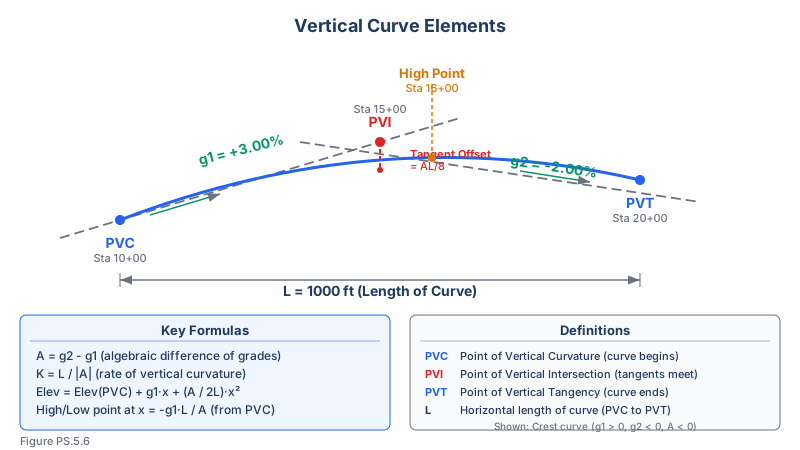
Vertical curves connect tangent grades in the profile view. They are typically parabolic curves.
Elements of a vertical curve:
| Element | Symbol | Definition |
|---|---|---|
| Point of Vertical Curvature | PVC | Beginning of the vertical curve |
| Point of Vertical Intersection | PVI | Intersection of the two grade lines |
| Point of Vertical Tangency | PVT | End of the vertical curve |
| Length of Curve | L | Horizontal distance from PVC to PVT |
| Grade In | g1 | Grade of the approaching tangent (as decimal, e.g., +0.03) |
| Grade Out | g2 | Grade of the departing tangent |
| Rate of Change | r | r = (g2 - g1) / L |
Vertical curve elevation formula:
Elevation at distance x from PVC: Elev(x) = Elev(PVC) + g1(x) + [(g2 - g1) / (2L)] x^2
Or equivalently: Elev(x) = Elev(PVC) + g1(x) + (r/2) x^2
Key stations:
- PVC station = PVI station - L/2
- PVT station = PVI station + L/2
- PVC elevation = PVI elevation - g1 x (L/2)
Types of vertical curves:
- Crest curve: g1 is more positive than g2 (concave downward); controls sight distance
- Sag curve: g1 is more negative than g2 (concave upward); controls headlight illumination distance
High/low point on a vertical curve: The high point of a crest curve (or low point of a sag curve) occurs at: x = -g1 / r = -g1 x L / (g2 - g1)
This point is critical for drainage design and sight distance analysis.
Superelevation
Superelevation is the banking of a roadway on curves to counteract centrifugal force:
- Maximum superelevation rates are set by design standards (typically 4-12%)
- Superelevation is introduced gradually through the spiral or transition zone
- The combined effect of superelevation and friction keeps vehicles on the road
Right-of-Way Surveys
Route projects require right-of-way (ROW) surveys to:
- Establish the existing property boundaries within the corridor
- Determine the land area needed for the project
- Prepare legal descriptions for acquisition parcels
- Identify and locate improvements, structures, and utilities within the ROW
- Support appraisal and negotiation for land acquisition
- Prepare ROW maps showing existing boundaries and proposed acquisition lines
Roadway and Utility Plans
Typical plan sheet components:
- Title sheet with project description and location map
- Summary of quantities
- Typical cross-sections
- Plan/profile sheets (plan view on top, profile view on bottom)
- Cross-section sheets
- Drainage plans and profiles
- Utility relocation plans
- Right-of-way maps
- Construction detail sheets
Utility surveys along routes:
- Locate existing utilities within the corridor (both overhead and underground)
- Coordinate utility relocations with utility companies
- Stake new utility installations (water, sewer, gas, electric, communications)
- Determine conflicts between proposed construction and existing utilities
Exam Tips
- Memorize the horizontal curve formulas: T = R tan(I/2), L = R x I (radians), C = 2R sin(I/2)
- PT station = PC station + L (arc length), NOT PI station + T -- this is a classic exam trap
- For vertical curves, the elevation formula Elev(x) = Elev(PVC) + g1(x) + [(g2-g1)/(2L)]x^2 is essential
- The high/low point on a vertical curve occurs at x = -g1L/(g2-g1) from PVC
- Degree of curve (arc definition): D = 5729.578/R -- know this conversion
- Crest curves control sight distance; sag curves control headlight illumination distance
- Stationing increases in one direction; left and right are defined facing the direction of increasing stations
- Remember that vertical curve length (L) is measured as horizontal distance, not along the slope
- Spiral curves transition from infinite radius (tangent) to the curve radius -- they are used to gradually introduce superelevation
Related Test Topics
- Construction surveys and staking (Topic 5.4)
- Surveying computations -- curves and coordinate geometry (Module 2, Topic 2.5)
- Right-of-way and boundary surveys (Topic 5.5)
- Topographic mapping along corridors (Topic 5.7)
- As-built surveys for completed routes (Topic 5.11)
- Plan reading and interpretation (Module 2, Topic 2.8)
Further Reading
Authoritative sources for deeper study
Kavanagh, Surveying with Construction Applications (7th Ed.) — Combined surveying and construction-layout reference.
Wolf & Ghilani, Elementary Surveying — Chapters on horizontal and vertical curve computations.
MUTCD 2023 Part 6 — Temporary Traffic Control — Federal standard for work-zone traffic control devices and surveyor safety.
Last updated: 2026-04-17