PS Exam Preparation
Comprehensive preparation for the NCEES Principles and Practice of Surveying (PS) exam. 5 modules covering all 5 exam domains with 50 in-depth topics.
Module 1: Legal Principles
Module 2: Professional Survey Practices
Module 3: Standards & Specifications
Module 4: Business Practices
Module 5: Areas of Practice
Evidence for PLSS Perpetuation
Learning Objectives
After completing this topic, you should be able to:
- Describe the structure and purpose of the Public Land Survey System
- Distinguish between original surveys and resurveys
- Explain the difference between dependent and independent resurveys
- Identify the types of corners in the PLSS and their relative authority
- Describe the BLM procedures for corner perpetuation and restoration
- Apply the principles of proportionate measurement
- Understand the role of the Manual of Surveying Instructions
- Evaluate PLSS evidence for corner recovery
Overview
The Public Land Survey System (PLSS) is the rectangular survey system established by the Land Ordinance of 1785 and extended across most of the United States west of the original thirteen colonies. Understanding the PLSS is essential for the PS exam because the original government survey created the boundaries that still control today. The corners set by the original GLO surveyors are the legal boundaries -- and the modern surveyor's duty is to find and perpetuate those corners, not to correct them.
The BLM Manual of Surveying Instructions (2009) is the authoritative reference for PLSS procedures. As the Manual states: "Under fundamental law, the corners of the original survey are unchangeable" (§5-29). More fully, "the boundaries and subdivision of the public lands as surveyed under approved instructions...are unchangeable after the passing of title by the United States" (§1-29). This principle -- the immutability of the original survey -- is the single most important concept in PLSS work.
Key Concepts
Structure of the PLSS
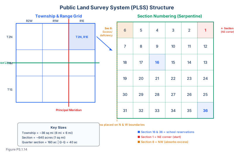
The PLSS divides land using a systematic grid:
| Element | Description | Typical Size |
|---|---|---|
| Principal Meridian | North-south reference line | Unique to each survey region |
| Base Line | East-west reference line | Unique to each survey region |
| Township | Rows of land north or south of the base line | 6 miles (nominal) |
| Range | Columns of land east or west of the principal meridian | 6 miles (nominal) |
| Township (tract) | The rectangular unit formed by a township row and range column | Approximately 36 square miles |
| Section | Subdivisions of a township, numbered 1-36 | Approximately 1 square mile (640 acres) |
| Quarter section | Subdivisions of a section | Approximately 160 acres |
Section numbering follows a serpentine (boustrophedon) pattern:
 6  5  4  3  2  1
 7  8  9 10 11 12
18 17 16 15 14 13
19 20 21 22 23 24
30 29 28 27 26 25
31 32 33 34 35 36
Section 1 is in the northeast corner; Section 36 is in the southeast corner. Section 16 was historically reserved for school purposes. Section 36 was also reserved for schools in later surveys.
Types of PLSS Corners
Understanding the hierarchy of corners is critical for retracement:
| Corner Type | Set By | Authority | Examples |
|---|---|---|---|
| Standard corners | Original GLO survey on standard parallels | Highest -- controls township exteriors | Standard township corners, closing corners |
| Township corners | Original GLO survey | Controls section locations within the township | Corners at township boundaries |
| Section corners | Original GLO survey | Controls quarter-section divisions | Corners of 1-mile sections |
| Quarter-section corners | Original GLO survey | Controls quarter-quarter divisions | Midpoints of section lines |
| Meander corners | Original GLO survey | Marks intersection of section/quarter lines with navigable water | Points where survey lines meet meandered water |
| Witness corners | Original GLO survey (where true corner is inaccessible) | Stands for the true corner | Set on line, near the true corner position |
| Reference points | Modern BLM survey | Perpetuates corner position | Typically 2+ reference points per corner |
The Immutability Doctrine
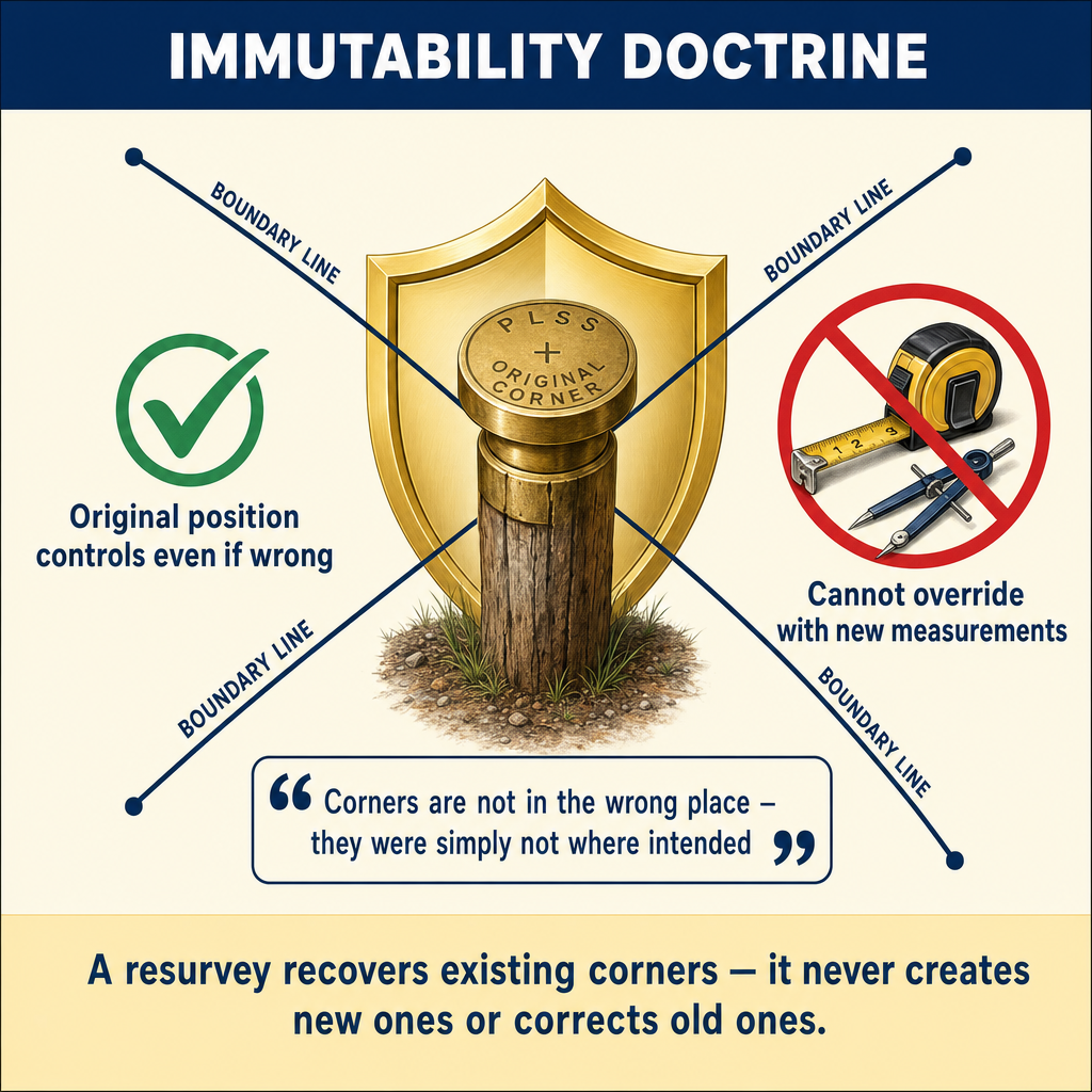
The foundational principle of PLSS work:
"Under fundamental law, the corners of the original survey are unchangeable." -- BLM Manual §5-29
This means:
- The original surveyor's monuments, when found, are the boundary -- regardless of whether they are in the theoretically correct position
- The modern surveyor cannot correct the original survey, even if the original surveyor made errors
- The original surveyor's field notes and plat are evidence of what was done, not a specification of what should have been done
- An original corner that is found in place controls over all other evidence, including the field notes
Why immutability? Because the government issued patents based on the original survey. Landowners purchased land based on the corners as set. Moving corners to "correct" the original survey would redistribute property among owners who relied on the original positions. The law protects the reliance interest of the original patentees and their successors.
Evidence of Original Corners
The surveyor evaluates corner evidence in a specific hierarchy:
1. The monument itself: The best evidence of an original corner is the original monument -- an iron post, stone, mound of stone, marked tree, or other monument described in the field notes. Finding the original monument in place is conclusive evidence of the corner location.
2. Accessories: Bearing trees, bearing objects, pits, and mounds described in the field notes serve as accessories to the corner monument. If the monument is gone but accessories remain, they can be used to recover the corner position.
3. Witness testimony: People who saw the monument in place or who know its location from personal knowledge may provide testimony. This is parol evidence and must be carefully evaluated.
4. Collateral evidence: Other surveys that referenced the corner, records of survey, fence lines built to the corner, and other indirect evidence of the corner's location.
5. Proportionate measurement: When a corner cannot be recovered from direct evidence, its position is calculated proportionately from the nearest recovered corners. This is the method of last resort.
Types of Resurveys
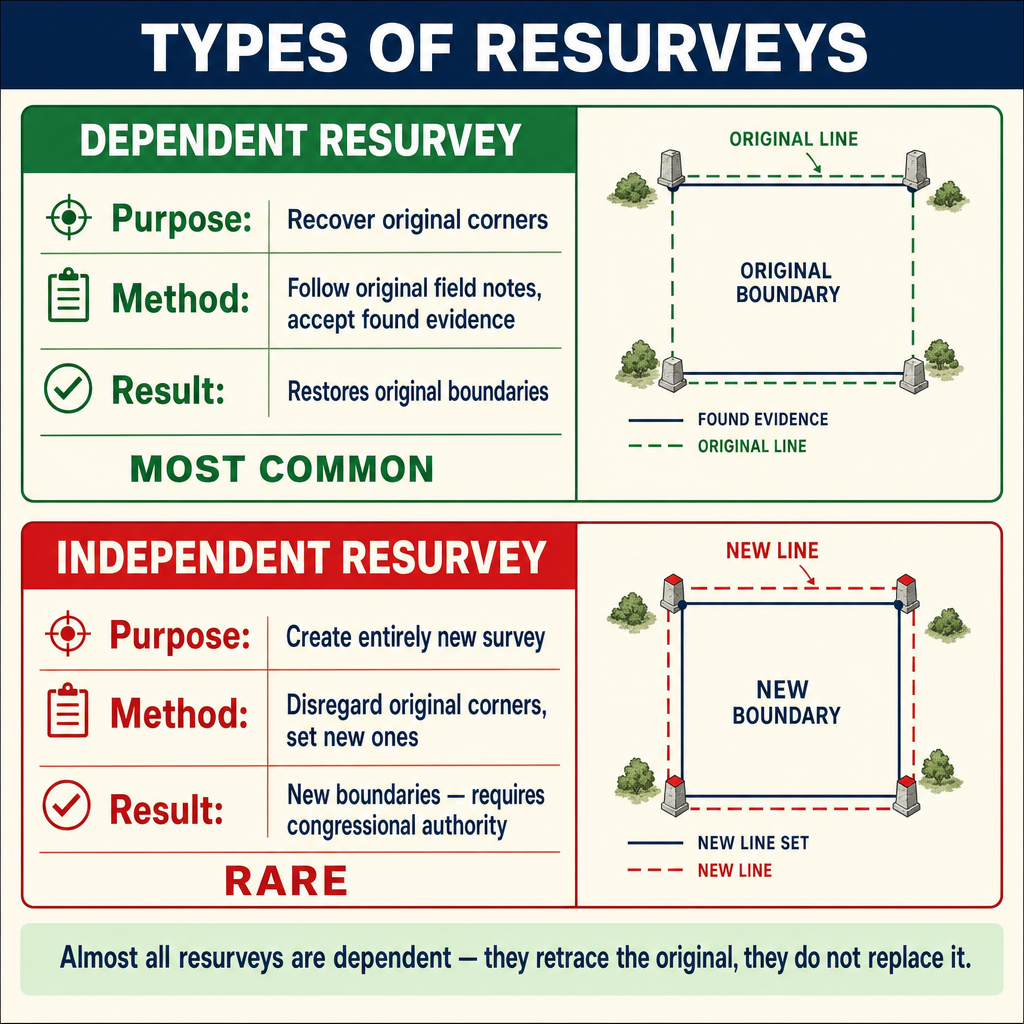
When corners are lost or obliterated, resurveys are conducted to restore them. Two primary types exist:
Dependent Resurvey
A dependent resurvey reestablishes the lines of the original survey based on evidence of the original corners. It is "dependent" because it depends on the original survey for its authority.
Characteristics:
- The most common type of resurvey
- Retraces the original survey lines as closely as possible
- Uses all available evidence to recover original corner positions
- Applies proportionate measurement where corners cannot be directly recovered
- Does not create new lines or new corners
- The goal is to restore the original survey to the ground
When used:
- Corners are lost or obliterated but sufficient evidence exists to restore them
- Property boundaries need to be reestablished for conveyance, litigation, or development
- The original survey was properly executed but corners have been destroyed
Independent Resurvey
An independent resurvey creates an entirely new survey that supersedes the original. It is rarely used and requires specific authorization.
Characteristics:
- Creates new section lines and corner positions
- Not controlled by the original survey
- Requires congressional authorization or administrative action
- Used only when the original survey is so defective that it cannot be restored
- Can redistribute acreage among sections
When used:
- The original survey was grossly fraudulent or defective
- The original survey was never actually performed (fraudulent returns)
- The original corners are so thoroughly lost that restoration is impossible
- Administrative determination that a new survey is the only practical solution
| Feature | Dependent Resurvey | Independent Resurvey |
|---|---|---|
| Authority | Follows original survey | Creates new survey |
| Corner positions | Restored from evidence | New positions established |
| Original corners | Sought and used if found | May not control |
| Proportionate measurement | Used for lost corners | Not applicable (new survey) |
| Authorization | Administrative | Congressional or special |
| Frequency | Common | Rare |
Corner Classification: Existent, Obliterated, Lost
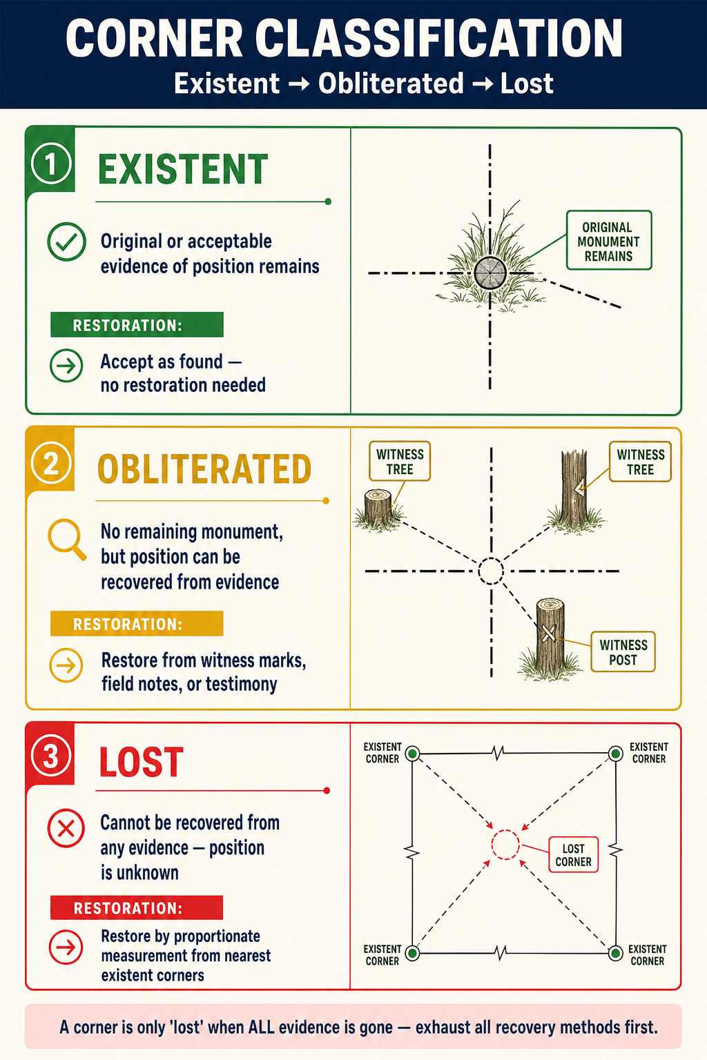
The BLM Manual classifies corners into three categories, each requiring a different recovery approach:
Existent Corner
A corner whose position can be determined beyond reasonable doubt from physical evidence. This includes:
- The original monument is found in place
- A monument of record (from a later official survey) is found in place
- Reliable accessories (bearing trees, bearing objects) mark the position
Treatment: Accept the corner as found. The original monument is the corner.
Obliterated Corner
A corner whose monument has been destroyed but whose position can be determined beyond reasonable doubt from evidence other than the original monument. This includes:
- Accessories (bearing trees, pits, mounds) remain and can be used to recover the position
- Reliable witness testimony establishes the position
- Other surveys referenced the corner and their measurements can be used
- Physical evidence (fence corners, building corners known to be at the corner) marks the position
Treatment: Restore the corner to its determined position based on the available evidence. The restored position has the same authority as the original corner.
Lost Corner
A corner whose position cannot be determined beyond reasonable doubt from any available evidence. All traces of the original monument and its accessories have been destroyed, and no reliable testimony or collateral evidence of its position exists.
Treatment: Restore the corner by proportionate measurement from the nearest recovered corners.
Proportionate Measurement
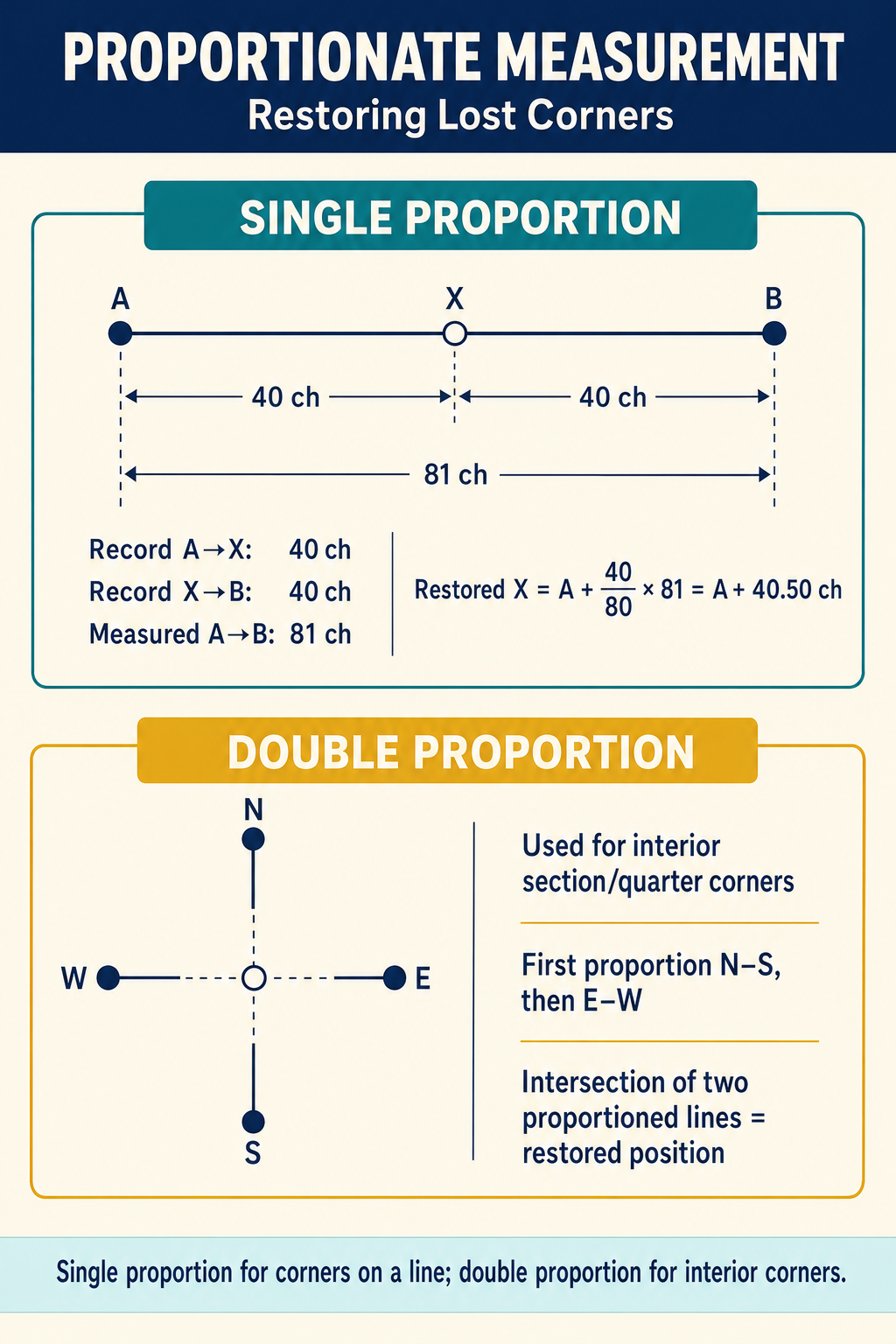
When a corner is truly lost, its position is restored by distributing the discrepancy between the original and measured distances proportionally among the intervals.
Single Proportion
Used when the lost corner lies on a line between two recovered corners:
Position of lost corner = (Original distance to lost corner / Original total distance) x Measured total distance
Example: The original field notes show corners A, B, and C along a section line, with A-B = 40 chains and B-C = 40 chains. Corner B is lost. The measured distance from A to C is 79.50 chains (instead of the original 80.00 chains). The restored position of B is:
B from A = 40/80 x 79.50 = 39.75 chains from A
Double Proportion
Used when the lost corner is at the intersection of two lines (such as a section corner at the intersection of a township line and a range line). The position is determined independently along each line and the two results are combined.
Steps:
- Proportion along the north-south line using the nearest recovered corners to the north and south
- Proportion along the east-west line using the nearest recovered corners to the east and west
- The latitude from step 1 and the departure from step 2 define the restored position
Standard Parallels and Correction Lines
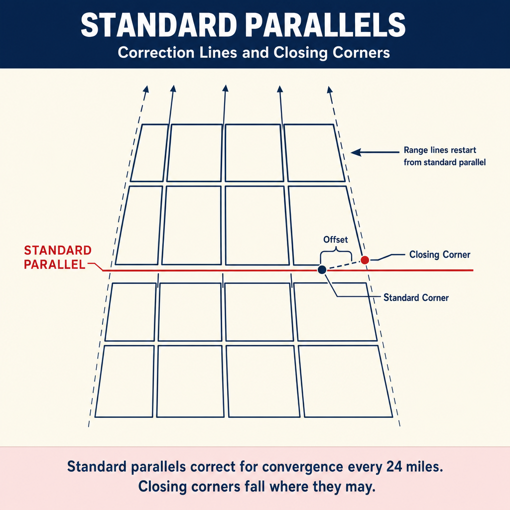
The PLSS accounts for the convergence of meridians (the fact that meridian lines get closer together as they approach the poles) through standard parallels (also called correction lines), typically run at intervals of 24 miles (every 4 townships).
Key points:
- Township lines are adjusted at standard parallels
- The excess or deficiency caused by convergence is placed in the north and west tiers of sections
- Section 6 (northwest corner of the township) absorbs the most adjustment
- Sections along the north and west boundaries of a township are often fractional
Closing Corners
A closing corner is set where a survey line intersects a previously established line. The closing corner is not at the same position as the standard corner on the previously established line -- there is typically a gap between them.
Critical rule: The closing corner is on the line being run; the standard corner is on the line previously established. They are different corners even if they are supposed to represent the same theoretical position. The closing corner controls for the township being closed; the standard corner controls for the previously surveyed township.
Common wrong path — treating closing corners and standard corners as interchangeable. On the ground, you may find two corner monuments within 10 or 20 feet of each other: a standard corner on the older township line and a closing corner set when a newer township was surveyed up to the older line. The exam baits students into picking "one is misplaced" or "one controls over the other" — both wrong. Both corners are controlling for their respective townships. The standard corner controls the township that was surveyed first; the closing corner controls the township that closed on the older line. The offset between them is a historical artifact of the original surveyors' measurements, preserved by the immutability doctrine. Do not move either; show both on the plat; and identify which controls for your client's parcel by determining which township the parcel belongs to.
Quick retrieval check — try before reading on.
▶A section line runs 80 chains on the original GLO plat. The south section corner is existent (found, undisturbed). The north section corner was destroyed. The quarter corner between them is also destroyed. The only other recovered corner is the next section corner to the north (one more section away), which measures 160.45 chains from the south existent corner. How do you restore the two lost corners?
This is a single-proportion problem with two unknowns on a line between two existent corners. Record distance from south existent corner to the next-north existent corner is 80 + 80 = 160.00 chains. Measured distance is 160.45 chains. The scale factor for proportioning is 160.45 / 160.00 = 1.002813.
- Lost section corner (originally at 80.00 chains): 80.00 × 1.002813 = 80.225 chains from the south existent corner.
- Lost quarter corner (originally at 40.00 chains on the first section, but it's the quarter corner of the first section, which is at 40.00 chains from the south section corner): 40.00 × 1.002813 = 40.113 chains from the south existent corner.
Note that only truly lost corners get proportioned — if any evidence of the quarter corner remained (a bearing-tree stump, reliable testimony, an old fence post at the expected location), it would be classified as obliterated and restored from that evidence without proportioning.
The Manual of Surveying Instructions
The BLM Manual of Surveying Instructions (2009 edition) is the authoritative reference for all PLSS work. Key chapters include:
| Chapter | Topic | Key Content |
|---|---|---|
| 3 | Initial Point, Baselines, Principal Meridians | Establishment of the survey framework |
| 4 | Standard Parallels | Correction for meridian convergence |
| 5 | Township Exteriors | Running and closing township lines |
| 6 | Subdivision of Sections | Interior section lines, aliquot parts |
| 7 | Resurveys | Dependent and independent resurvey procedures |
| 8 | Special Surveys | Mineral, island, and other special surveys |
| 9 | Corner Evidence | Corner classification, recovery, perpetuation |
Corner Perpetuation
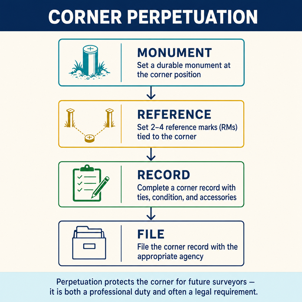
The surveyor has a professional and often legal obligation to perpetuate PLSS corners. Perpetuation involves:
- Recovery: Finding the original or restored corner position
- Monumentation: Setting a durable monument if the original is gone
- Reference points: Establishing at least two reference points (ties) to recover the corner if the monument is again destroyed
- Documentation: Filing a corner record or record of survey as required by state law
- Protection: Taking reasonable steps to protect the monument from disturbance
Most state surveying practice acts require that any surveyor who finds a survey monument in the path of construction must take steps to protect and perpetuate it. The specific requirements vary by jurisdiction.
Exam Tips
- The original survey is unalterable -- this is the most fundamental PLSS principle
- Know the three corner classifications: existent (found), obliterated (position recoverable), lost (position unknown)
- Lost corners are restored by proportionate measurement; obliterated corners are restored from evidence
- Dependent resurveys retrace the original; independent resurveys create a new survey (rare)
- Section numbering starts at the northeast corner (Section 1) and follows a serpentine pattern
- Excess and deficiency in townships falls on the north and west boundaries
- The closing corner and the standard corner are different corners even if they represent the same theoretical point
- Single proportion is used for corners on a line; double proportion is used for corners at intersections
- Original monuments found in place control over all other evidence, including the field notes
- Meander lines are not boundaries -- the water body is the boundary (see Topic 1.7)
- A quarter-section corner is at the midpoint of the section line as originally surveyed, not as calculated from modern measurements
- Know Section 16 (and Section 36 in later surveys) were reserved for school purposes
- The Manual of Surveying Instructions (2009) is the authoritative BLM reference -- know its general structure
Related Test Topics
- Legal Descriptions (Topic 1.9)
- Controlling Elements (Topic 1.5)
- Searching and Evaluating Evidence (Topic 1.1)
- Riparian, Littoral, and Sovereign Rights (Topic 1.7)
- Sequential and Simultaneous Conveyances (Topic 1.8)
Further Reading
Authoritative sources for deeper study
BLM Manual of Surveying Instructions (2009), Ch. V — Restoration of lost and obliterated corners.
Mulford, Boundaries and Landmarks — Classic public-land-system boundary reference (public domain).
Robillard & Bouman, A Treatise on the Public Land Surveying System / Public Land Surveying Casebook — Application of BLM Manual principles in the field.
Brown's Boundary Control and Legal Principles (7th Ed., Robillard & Wilson) — Standard textbook on boundary law, evidence hierarchy, and retracement.
Last updated: 2026-04-17