PS Exam Preparation
Comprehensive preparation for the NCEES Principles and Practice of Surveying (PS) exam. 5 modules covering all 5 exam domains with 50 in-depth topics.
Module 1: Legal Principles
Module 2: Professional Survey Practices
Module 3: Standards & Specifications
Module 4: Business Practices
Module 5: Areas of Practice
Land Development Solutions
Learning Objectives
After completing this topic, you should be able to:
- Describe the surveyor's role in the land development process from concept through construction
- Identify regulatory requirements affecting subdivision and site development
- Explain grading plan elements including cut/fill calculations and drainage design
- Understand utility layout considerations and easement requirements
- Apply setback, lot size, and frontage requirements from zoning and subdivision regulations
- Describe construction staking procedures for buildings, roads, and utilities
- Understand the relationship between preliminary and final subdivision maps
Overview
Land development is one of the most comprehensive applications of professional surveying. The surveyor serves as a critical member of the development team from initial feasibility through final construction, providing boundary definition, topographic data, design support, regulatory compliance, construction staking, and final as-built documentation.
The surveyor's involvement in land development extends well beyond simple measurement. Understanding regulatory frameworks, drainage principles, grading concepts, and construction processes enables the surveyor to contribute effectively to project planning and to identify potential problems before they become costly errors.
Key Concepts
The Development Process
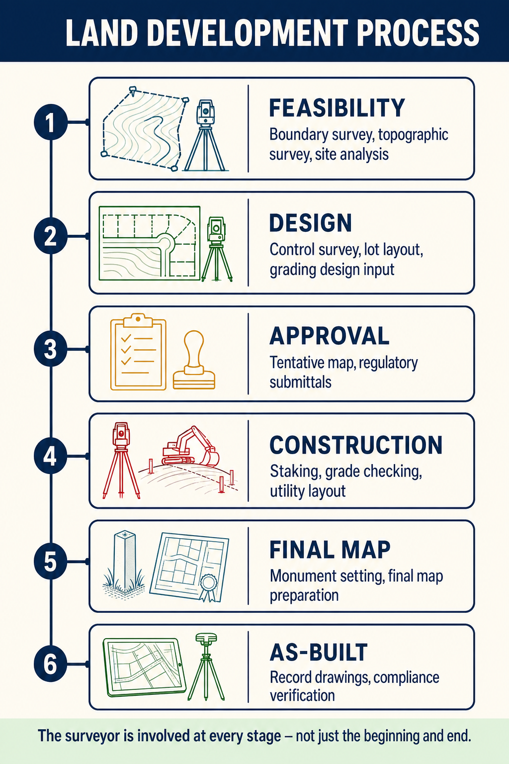
Land development follows a general sequence in which the surveyor plays a role at each stage:
| Phase | Survey Activities |
|---|---|
| Feasibility | Records research, preliminary boundary survey, topographic survey, environmental constraints mapping |
| Entitlement | Tentative map preparation, boundary survey, zoning analysis, environmental review support |
| Design | Design survey, utility survey, grading design support, easement planning |
| Permitting | Final map preparation, improvement plans, legal descriptions for dedications |
| Construction | Construction staking (rough grade, fine grade, buildings, utilities), progress surveys |
| Completion | As-built survey, monument setting, final map recordation, lot corner staking |
Regulatory Framework
Land development is governed by overlapping layers of regulation at federal, state, and local levels.
Federal Regulations
| Regulation | Application |
|---|---|
| Clean Water Act | Wetlands protection, stormwater management |
| Endangered Species Act | Habitat preservation, species surveys |
| FEMA flood regulations | Floodplain management, base flood elevation |
| ADA requirements | Accessible routes, grades, cross-slopes |
State Requirements
State subdivision laws typically regulate:
- Map requirements -- tentative and final map content, format, and filing procedures
- Dedications -- streets, utilities, drainage, open space
- Improvement standards -- road widths, grades, curve radii
- Environmental review -- state environmental protection acts (NEPA at the federal level)
- Monument requirements -- what must be set and when
Local Regulations
Cities and counties impose additional requirements through:
- Zoning ordinances -- use restrictions, density limits, setbacks, height limits, lot coverage
- Subdivision ordinances -- design standards, improvement requirements
- Grading ordinances -- cut/fill limitations, erosion control, slope stability
- Building codes -- setback verification, grade requirements
- Design standards -- road cross-sections, utility specifications, drainage requirements
Subdivision Design
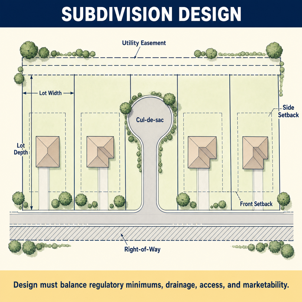
Lot Layout Considerations
The surveyor and engineer must balance multiple factors in subdivision design:
| Factor | Considerations |
|---|---|
| Zoning compliance | Minimum lot size, frontage, width, depth requirements |
| Topography | Street grades, lot drainage, buildable pad areas |
| Access | Street connectivity, emergency access, circulation |
| Utilities | Water, sewer, storm drain, electric, gas, communication |
| Environmental | Setbacks from sensitive areas, tree preservation, habitat |
| Marketability | Lot shapes, views, orientation, desirable lot sizes |
| Phasing | Logical construction sequence, temporary access, interim conditions |
Street Design
Street design in subdivisions must comply with local standards for:
| Element | Typical Requirements |
|---|---|
| Right-of-way width | 50-80 feet for local streets (varies by jurisdiction) |
| Pavement width | 32-40 feet for local streets |
| Minimum centerline radius | 100-300 feet for local streets |
| Maximum grade | 6-15% depending on street classification |
| Minimum grade | 0.5% for drainage |
| Cul-de-sac radius | 40-50 foot right-of-way radius |
| Intersection spacing | Minimum distance between intersections |
| Sight distance | Adequate stopping sight distance at intersections |
Cul-de-Sac and Turnaround Design
Cul-de-sacs require careful geometric design:
- The bulb must accommodate emergency vehicle turning radii
- Lot frontage on the arc must meet minimum requirements
- Side lot lines typically radiate from the center of the bulb or are perpendicular to the arc
- Utility easements within the bulb must be coordinated with lot lines
Grading Plans
Cut and Fill
Grading plans show the proposed modification of existing terrain. Key concepts include:
Cut -- excavation of earth to lower the existing grade to the design grade.
Fill -- placement of earth to raise the existing grade to the design grade.
Balance -- the goal of balancing cut and fill quantities so that material removed from cut areas can be used in fill areas, minimizing import or export of earth.
Volume Computation Methods
| Method | Description | Best Application |
|---|---|---|
| Average end area | Compute area of cut/fill at each cross-section, average adjacent sections, multiply by distance | Linear features (roads, channels) |
| Prismoidal formula | More accurate than average end area, accounts for variation between sections | When higher accuracy is needed |
| Grid method | Compare existing and proposed elevations at grid points | Area grading, building pads |
| Surface-to-surface | Compare TIN or grid surfaces digitally | Modern software-based computation |
The average end area method tends to overestimate volumes, particularly where the cross-sections change significantly between stations. The prismoidal correction adjusts for this overestimation.
Drainage Design Principles
Proper drainage is essential in any development:
- Minimum grades for drainage (typically 1-2% for paved surfaces, 2-5% for unpaved)
- Lot drainage -- each lot must drain to a street, storm drain, or approved facility
- Concentration points -- avoid directing drainage from one lot across another
- Drainage easements -- required where drainage crosses private property
- Retention/detention -- facilities to manage increased runoff from development
Utility Layout
Common Utilities and Easement Requirements
| Utility | Typical Easement Width | Location |
|---|---|---|
| Sanitary sewer | 10-20 feet | Typically in street or rear easement |
| Storm drain | 10-20 feet | Street, drainage channels, or easements |
| Water main | 10-15 feet | Typically in street |
| Gas | 5-10 feet | Street or front easement |
| Electric | 5-10 feet | Street, front or rear easement |
| Telephone/cable | 5-10 feet | Often shared with electric |
Utility Coordination
The surveyor's role in utility coordination includes:
- Documenting existing utility locations through field survey and utility records research
- Ensuring proposed utility routes have adequate easement coverage
- Verifying horizontal and vertical clearances between utilities
- Identifying conflicts between proposed improvements and existing facilities
- Preparing legal descriptions for utility easements
Construction Staking
Construction staking translates design plans into physical marks on the ground that guide construction. The surveyor provides horizontal and vertical control for:
Types of Construction Staking
| Staking Type | Description |
|---|---|
| Rough grading | Cut/fill stakes at grid points or cross-section stations showing existing and design elevations |
| Fine grading | Precise grade stakes for finished surfaces, building pads, parking lots |
| Building layout | Building corners, column lines, foundation lines |
| Street construction | Centerline, curb and gutter, flow line, edge of pavement |
| Utility installation | Pipe invert elevations, manhole locations, horizontal alignment |
| Slope staking | Marks where cut or fill slopes intersect existing ground (catch points) |
| Offset staking | Stakes placed at known offsets from the design feature to avoid disturbance during construction |
Stake Marking Conventions
Construction stakes are marked with standardized information:
| Marking | Meaning |
|---|---|
| C 2.5 | Cut 2.5 feet (excavate to reach design grade) |
| F 1.8 | Fill 1.8 feet (add material to reach design grade) |
| FL 98.50 | Flow line elevation 98.50 |
| TC 100.25 | Top of curb elevation 100.25 |
| INV 95.30 | Pipe invert elevation 95.30 |
| 5' R/O | 5-foot right offset from design feature |
Tentative and Final Maps
Tentative Map
The tentative map is the initial submission for subdivision approval. It shows the proposed lot layout, street design, and site features for agency review. The tentative map typically shows:
- Proposed lot lines with dimensions and areas
- Proposed streets with centerlines, right-of-way widths, and grades
- Existing topography and improvements
- Proposed grading concept
- Utility layout
- Environmental features and constraints
- Proposed dedications and easements
Final Map
The final map is the recordable document that creates the subdivision as a legal entity. Requirements include:
- Precise boundary and lot dimensions based on field survey
- Monuments set (or to be set) at all required locations
- Certificates from the surveyor, owner, and approving agencies
- Dedication statements for streets, easements, and public facilities
- Basis of bearings and coordinate references
- Compliance with all conditions of tentative map approval
The final map must be based on a field survey and must close mathematically. All lots must meet minimum standards for size, frontage, depth, and width as specified by the governing ordinances.
Common wrong path — assuming tentative-map approval binds the final map in all details. Tentative map approval authorizes the subdivider to proceed with final engineering and final map preparation, subject to the conditions of approval. Students sometimes assume the tentative map controls everything about the final map; in reality, (a) the final map must be based on an accurate field survey, not the tentative map's preliminary layout; (b) minor adjustments in lot lines, dimensions, or easements are permissible if they remain consistent with the tentative map's basic design; (c) any substantive change from the tentative map requires a revised tentative map and new approval; and (d) all conditions of approval must be satisfied before recordation. Exam questions test this by describing a discrepancy between the tentative map and the field-surveyed final map and asking whether the final map can be recorded; the correct answer depends on whether the discrepancy is consistent with the approval conditions, not on whether it exactly matches the tentative map.
Quick retrieval check — try before reading on.
▶A tentative map approved two years ago shows lot dimensions of 60 ft x 120 ft for lot 5. During final survey, the actual field-measured dimensions based on monumentation come out to 60.12 ft x 119.87 ft. Can the final map be recorded with these actual dimensions, or must the dimensions exactly match the tentative map?
The final map can be recorded with the actual field-measured dimensions, assuming the change is minor and consistent with the overall design approved by the tentative map. Field surveys invariably produce dimensions that differ slightly from the preliminary tentative-map dimensions — the tentative map is based on concept-level design, while the final map reflects the actual survey-accurate positions of monuments and lot corners. The approving agency generally understands and accepts small dimensional refinements as part of the final mapping process.
That said, the final map must (a) maintain compliance with the minimum lot size, frontage, and width requirements (still met here: 60.12 x 119.87 ≈ 7,204 sq ft); (b) fit within the overall subdivision geometry approved by the tentative map (street alignment, block layout, easement locations); (c) comply with all conditions of approval; and (d) not create any substantive departure from the approved design. If the changes are larger — a lot that falls below the minimum required dimension, a new street alignment, a repositioned easement — the subdivider may need to submit a revised tentative map or request agency concurrence with the modification. Verify your specific jurisdiction's rules, but in general, small field-based refinements are not only permitted but expected.
As-Built Surveys
After construction is complete, the surveyor documents what was actually built:
- Actual positions of improvements compared to design
- Final grade elevations
- Utility locations and invert elevations
- Building positions relative to property lines (setback verification)
- Drainage structures and flow lines
- Monument positions (set during or after construction)
As-built information becomes the permanent record of the development and is essential for future maintenance, modification, and boundary work.
Exam Tips
- The surveyor's role in land development spans from feasibility through final as-built documentation
- Cut/fill stakes show the difference between existing grade and design grade
- The average end area method tends to overestimate volumes
- Every lot in a subdivision must have positive drainage to an approved outlet
- Utility easements must be coordinated with lot lines and other improvements
- Offset stakes are placed away from the design feature to avoid disturbance during construction
- The final map creates the subdivision as a legal entity and must be based on a field survey
- Tentative map approval conditions must all be satisfied before a final map can be recorded
Related Test Topics
- State subdivision law requirements (Module 1)
- Survey maps, plats, and reports (Topic 2.8)
- Surveying computations for design (Topic 2.5)
- Field techniques for construction staking (Topic 2.2)
- Documentation of construction surveys (Topic 2.10)
- CAD and design software (Topic 2.12)
Further Reading
Authoritative sources for deeper study
Kavanagh, Surveying with Construction Applications (7th Ed.) — Combined surveying and construction-layout reference.
2021 ALTA/NSPS Land Title Survey Standards — Current minimum standard detail requirements for ALTA/NSPS land title surveys.
Wolf & Ghilani, Elementary Surveying — An Introduction to Geomatics (13th+ Ed.) — Comprehensive surveying text covering instruments, field procedures, and computations.
Last updated: 2026-04-17