PS Exam Preparation
Comprehensive preparation for the NCEES Principles and Practice of Surveying (PS) exam. 5 modules covering all 5 exam domains with 50 in-depth topics.
Module 1: Legal Principles
Module 2: Professional Survey Practices
Module 3: Standards & Specifications
Module 4: Business Practices
Module 5: Areas of Practice
Legal Descriptions for Real Property
Learning Objectives
After completing this topic, you should be able to:
- Identify and distinguish the three primary types of legal descriptions
- Interpret a metes and bounds description and trace it on a plat
- Read and interpret PLSS descriptions (section, township, range, principal meridian)
- Understand subdivision (lot and block) references and their legal effect
- Explain the rules for interpreting ambiguous or conflicting description elements
- Recognize common errors in legal descriptions
- Describe the surveyor's role in preparing and reviewing legal descriptions
Overview
A legal description is the formal written identification of a parcel of real property that is sufficient to locate and identify the parcel with certainty. Legal descriptions are the foundation of the conveyance system -- they are the means by which the written world of deeds and titles connects to the physical world of land and boundaries.
As Wattles emphasizes throughout Writing Legal Descriptions (1976), a legal description must isolate one parcel — and only one — and must do so with enough certainty that a competent surveyor can later locate the land on the ground from the writing alone. Identification "to the exclusion of all other land" is the working test by which the courts have long judged whether a description is sufficient.
The surveyor must be able to both interpret existing legal descriptions (for retracement surveys) and prepare new legal descriptions (for subdivisions, lot line adjustments, and conveyances). Both skills are tested on the PS exam.
Key Concepts
The Three Primary Types of Legal Descriptions

1. Metes and Bounds
Metes and bounds is the oldest and most flexible system of land description. It describes a parcel by stating a point of beginning and then tracing the boundaries of the parcel by courses (direction and distance) and calls for monuments until returning to the point of beginning.
Components of a metes and bounds description:
| Component | Description | Example |
|---|---|---|
| Caption | Identifies the larger tract or reference | "A parcel of land situated in Section 12, T3N, R4W, 5th P.M." |
| Point of Beginning (POB) | The starting point of the boundary trace | "Beginning at an iron pipe at the SW corner of the NE 1/4" |
| Courses | Direction and distance of each boundary line | "Thence North 45 degrees 30 minutes East, 200.00 feet" |
| Calls for monuments | References to physical features along the boundary | "to an iron pipe set at the northerly bank of Smith Creek" |
| Calls for adjoiners | References to neighboring properties | "along the easterly line of the Jones tract" |
| Closure | Return to the point of beginning | "to the Point of Beginning" |
| Area statement | The enclosed area (informational only) | "Containing 2.35 acres, more or less" |
Rules for interpreting metes and bounds descriptions:
- The description must close -- it must return to the point of beginning
- Courses are read in sequence; gaps or overlaps indicate errors
- Monument calls control over courses and distances (per the hierarchy)
- "More or less" after an area statement means the area is approximate
- "Thence" means continuing from the last point described
- Direction is stated from the point of beginning outward along each line
Common errors in metes and bounds descriptions:
- Non-closure (mathematical error in courses)
- Calling for monuments that do not exist or cannot be found
- Reversed bearings (writing S45E when N45W was intended)
- Omitting a course
- Describing a parcel that overlaps with an adjacent description
- Using the wrong point of beginning
Common wrong path — "reversed bearing" is easy to miss in the field. When a metes-and-bounds description contains a reversed bearing (e.g., "N 45° W" written where "S 45° E" was intended), students often detect the error only when the parcel fails to close — and then blame the distance calls instead. The tell is a sudden 180° deflection in the perimeter walk: the boundary appears to reverse direction, re-trace back over itself, then continue. When you plot a description and see this "bowtie" pattern, check the bearings for a reversed call, not the distances. Similarly, if the description closes but the resulting parcel has an impossible shape (crossing itself, or adjacent to land the deed clearly does not describe), suspect a reversed bearing. Fixing the wrong error — adjusting distances when a bearing is reversed — leaves the real problem in place and introduces new ones.
Quick retrieval check — try before reading on.
▶A deed describes the last course of a parcel as "thence N 85° 00' E, 120.00 ft to the Point of Beginning." You plot the description and find the final course lands 240 ft short of the POB, aligned along the called bearing. What is the most likely explanation and how do you resolve it?
A reversed-bearing error is a strong candidate — specifically, one of the earlier courses may have been written as its reciprocal. Landing 240 ft short on the closing leg means the parcel's perimeter traced an extra 120 ft in the wrong direction somewhere and then "came back"; that pattern is diagnostic of a 180° reversal of a single intermediate course. To resolve: walk through each preceding course and look for a bearing that, if reversed, produces closure. If an earlier course reads "S 30° W, 120.00 ft" and reversing it to "N 30° E, 120.00 ft" closes the parcel, you have found the error. Document the analysis in your boundary narrative, show both the record description and the apparent correct interpretation, and — because this is a legal document — do not rewrite the deed. Reporting the likely error is the surveyor's role; correcting the deed requires the parties' action (corrective deed, quiet title, etc.).
2. Public Land Survey System (PLSS)
The PLSS (also called the rectangular survey system or government survey) describes land by reference to the federal survey grid. It is used throughout the western United States and in states surveyed under the authority of the General Land Office (GLO) and its successor, the Bureau of Land Management (BLM).
Components of a PLSS description:
| Component | Description | Example |
|---|---|---|
| Principal Meridian | The reference meridian for the survey | 5th Principal Meridian (5th P.M.) |
| Township | North-south position (6-mile rows) | Township 3 North (T3N) |
| Range | East-west position (6-mile columns) | Range 4 West (R4W) |
| Section | 1-mile square within the township (numbered 1-36) | Section 12 |
| Aliquot part | Subdivision of the section | NW 1/4 of the SE 1/4 |
Reading PLSS descriptions:
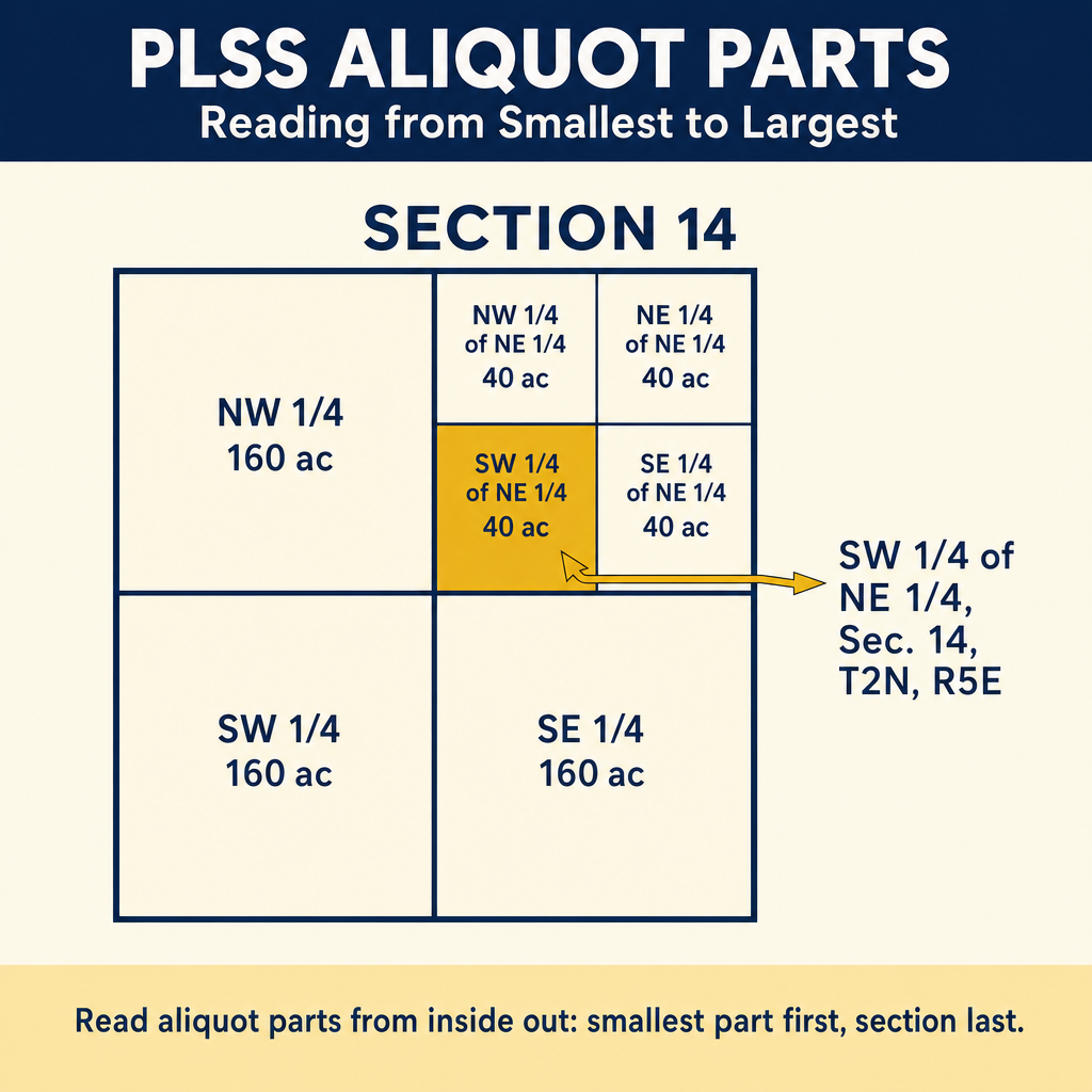
PLSS descriptions are written smallest-first but located largest-first — you read them from the specific subdivision back up to the principal meridian, then turn around and walk the location from the meridian down to the parcel:
"The NW 1/4 of the SE 1/4 of Section 12, T3N, R4W, 5th Principal Meridian"
To locate this parcel:
- Find the 5th Principal Meridian
- Go to Township 3 North, Range 4 West
- Find Section 12
- Find the SE 1/4 of Section 12
- Find the NW 1/4 of that SE 1/4
Standard subdivisions of a section:
A standard section is 640 acres (one square mile). It is subdivided into:
| Division | Acres | Dimensions |
|---|---|---|
| Section | 640 | 5,280 ft x 5,280 ft |
| Half section | 320 | 5,280 ft x 2,640 ft |
| Quarter section | 160 | 2,640 ft x 2,640 ft |
| Half of quarter | 80 | 2,640 ft x 1,320 ft |
| Quarter of quarter | 40 | 1,320 ft x 1,320 ft |
Important: These are theoretical dimensions. Actual sections vary due to convergence of meridians, measurement error, and the placement of excess or deficiency along the north and west boundaries of the township.
Fractional sections occur along the north and west boundaries of townships and along irregular boundaries (rivers, state lines). Fractional sections contain government lots numbered on the original plat.
3. Subdivision (Lot and Block)
Subdivision descriptions (also called lot and block or plat references) describe land by reference to a recorded subdivision plat or map.
Format: "Lot 5, Block 3, Green Acres Subdivision, as per map recorded in Book 10, Page 50 of Maps, records of Franklin County, State"
Key characteristics:
- The simplest and least ambiguous form of legal description
- The plat becomes part of the deed by incorporation
- Lot dimensions and boundaries are shown on the plat
- The plat reference must include sufficient information to locate the recorded map
- Lot corners shown on the plat are the legal boundaries
Elements that must be included:
- Lot number
- Block number (if applicable)
- Subdivision name
- Recording reference (book, page, or instrument number)
- County and state
Legal effect of the plat:
When a deed references a subdivision plat, the plat is incorporated into the deed as if its contents were written out in full. This means:
- All dimensions shown on the plat are part of the deed
- All monuments shown on the plat are called for
- Easements shown on the plat burden the affected lots
- Setback lines shown on the plat are binding
- Common areas dedicated on the plat are public or association property
Combined Descriptions
Many legal descriptions combine elements from multiple systems:
Example: "The West 100 feet of Lot 7, Block 2, Happy Valley Estates, as per map recorded in Book 20, Page 12 of Maps, records of Marion County, State, being a portion of the NE 1/4 of Section 15, T9N, R5E, 5th Principal Meridian."
This description uses:
- Metes and bounds (the west 100 feet)
- Lot and block (Lot 7, Block 2)
- PLSS (NE 1/4 of Section 15)
Rules for Interpreting Legal Descriptions
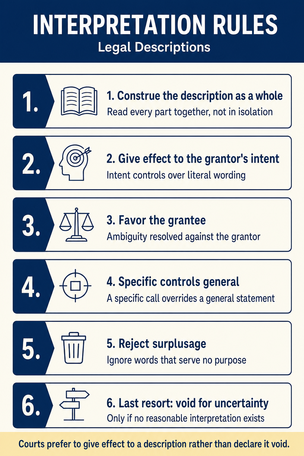
Several well-established rules guide the interpretation of legal descriptions:
1. The description must be interpreted as a whole. Individual words or phrases are not read in isolation but in the context of the entire description.
2. Every part of the description should be given effect. Courts try to reconcile all elements of a description rather than discarding any part. Only when reconciliation is impossible will a court discard a conflicting element.
3. Specific descriptions control over general descriptions. A metes and bounds description controls over a general reference to "the Smith farm" when they conflict.
4. The hierarchy of controlling elements applies. When elements conflict, apply SICMoMe (Topic 1.5).
5. The grantor's intent governs. The description is interpreted to effectuate the intent of the grantor at the time of the conveyance.
6. Descriptions are construed most strongly against the grantor. If a description is ambiguous, it is interpreted in the way most favorable to the grantee (the grantor chose the words and bears the risk of ambiguity).
7. "More or less" means approximate. Area and distance statements followed by "more or less" are understood to be approximate and are subordinate to monuments and more specific calls.
8. Monuments prevail over courses and distances. When a monument and a measurement conflict, the monument controls (assuming it is called for, identifiable, and undisturbed).
The Surveyor's Role in Legal Descriptions
Preparing Legal Descriptions
When preparing a legal description, the surveyor must ensure:
- Uniqueness: The description identifies one and only one parcel
- Sufficiency: A competent surveyor can locate the parcel from the description alone
- Accuracy: Measurements and references are correct
- Closure: The metes and bounds description closes mathematically
- Monument references: The description calls for stable, identifiable monuments
- Consistency: Internal elements do not conflict
- Completeness: All necessary elements are included
Reviewing Legal Descriptions
When reviewing an existing legal description (for a retracement survey), the surveyor should:
- Read the entire description before beginning the retracement
- Identify all calls -- monuments, courses, distances, adjoiners, references
- Check for mathematical closure of metes and bounds descriptions
- Obtain referenced plats and surveys to incorporate into the analysis
- Compare the description to the ground -- locate called-for monuments
- Identify conflicts between description elements and apply the hierarchy
- Note errors and ambiguities for the client and (if necessary) legal counsel
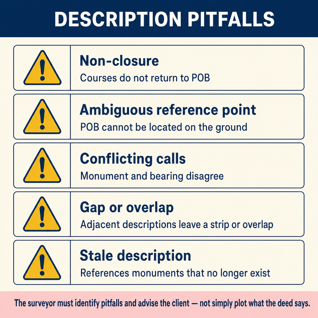
Common Description Pitfalls
| Pitfall | Example | Problem |
|---|---|---|
| Vague reference | "The property near the oak tree" | Not sufficiently definite to locate |
| Circular description | Describes bounds by reference to itself | Self-referential, cannot be located independently |
| Insufficient reference | "Lot 5, Green Acres" | Missing recording reference (book, page) |
| Overlapping descriptions | Two deeds describing the same strip | Creates a title dispute |
| Defective closure | Course sequence does not return to POB | Mathematical error; parcel cannot be defined |
| Obsolete monuments | Calls for a feature that no longer exists | Creates a latent ambiguity requiring investigation |
| Wrong datum or bearings | Bearings referenced to wrong meridian | All directions are systematically wrong |
| Transposition errors | Lot 7 written as Lot 17 | Wrong parcel identified |
Exam Tips
- Know the three types of legal descriptions and when each is used
- Metes and bounds descriptions must close -- non-closure indicates an error
- PLSS descriptions are written smallest-first (quarter-quarter, quarter, section, township, range, principal meridian) and located largest-first — find the PM first, then township/range, then section, then narrow to the quarter-quarter
- A standard section is 640 acres; a quarter section is 160 acres; a quarter-quarter is 40 acres
- When a deed references a plat, the plat is incorporated by reference and its contents are part of the deed
- "More or less" means the quantity is approximate and subordinate to monuments
- Specific descriptions control over general descriptions
- Ambiguous descriptions are construed against the grantor (the grantor chose the words)
- The hierarchy of controlling elements (SICMoMe) governs when description elements conflict
- Fractional sections are found along the north and west boundaries of townships
- Area is the weakest measurement call -- it almost never controls over other elements
- Exam questions often present descriptions with conflicting elements and ask which controls -- apply the hierarchy systematically
Related Test Topics
- Controlling Elements (Topic 1.5)
- PLSS Perpetuation (Topic 1.10)
- Sequential and Simultaneous Conveyances (Topic 1.8)
- Parol Evidence (Topic 1.2)
- Searching and Evaluating Evidence (Topic 1.1)
Further Reading
Authoritative sources for deeper study
Wattles, Writing Legal Descriptions (1976) — Gold-standard reference on metes-and-bounds, sectional, and combination descriptions.
Brown's Boundary Control and Legal Principles (7th Ed., Robillard & Wilson) — Standard textbook on boundary law, evidence hierarchy, and retracement.
Evidence and Procedures for Boundary Location (Robillard, Wilson, & Brown, 7th Ed.) — Practical treatise on collecting, weighing, and applying boundary evidence.
Last updated: 2026-04-17