PS Exam Preparation
Comprehensive preparation for the NCEES Principles and Practice of Surveying (PS) exam. 5 modules covering all 5 exam domains with 50 in-depth topics.
Module 1: Legal Principles
Module 2: Professional Survey Practices
Module 3: Standards & Specifications
Module 4: Business Practices
Module 5: Areas of Practice
Datums, Reference Frames & Equipment
Learning Objectives
After completing this topic, you should be able to:
- Define and distinguish between horizontal and vertical geodetic datums
- Explain the development and characteristics of NAD 27 and NAD 83
- Describe the differences between NGVD 29 and NAVD 88
- Identify the role of WGS 84, ITRF, and GRS 80 in modern surveying
- Explain why datum transformations are necessary and how they are performed
- Describe the equipment used for geodetic control surveys
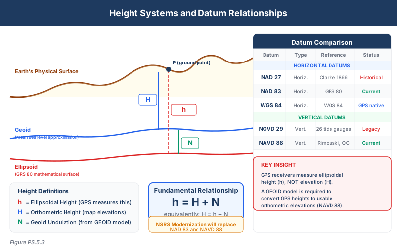
- Understand the relationship between ellipsoid heights, geoid heights, and orthometric heights
Overview
A geodetic datum defines the reference framework used to express positions on or near the Earth's surface. Horizontal datums establish the basis for latitude/longitude and plane coordinates; vertical datums establish the basis for elevations. Every survey measurement is referenced to a datum, and mixing datums or applying the wrong datum transformation is a common source of significant error.
The PS exam tests your understanding of the major datums used in the United States, their historical development, their relationships to each other, and the practical implications of datum selection and transformation.
Key Concepts
What Is a Datum?
A datum consists of:
- A reference surface -- An ellipsoid (for horizontal datums) or a geoid/tidal surface (for vertical datums)
- An origin -- A defined starting point or set of constraints
- A realization -- The physical network of control stations whose published coordinates define the datum in practice
Changing the datum changes the coordinates of every point, even though nothing has physically moved on the ground.
Horizontal Datums
NAD 27 (North American Datum of 1927)
| Characteristic | Value |
|---|---|
| Reference ellipsoid | Clarke 1866 |
| Origin | Meades Ranch, Kansas (fixed point) |
| Adjustment | Piecemeal, over many decades |
| Coordinate system | Latitude/longitude; State Plane (US feet) |
| Limitations | Distortions accumulate away from origin; inconsistent adjustments |
NAD 27 was the standard horizontal datum for the U.S. for over 50 years. Its key limitations include:
- Fixed origin at Meades Ranch created systematic distortions across the continent
- The Clarke 1866 ellipsoid does not fit the Earth as well as modern ellipsoids
- Piecemeal adjustments over decades introduced internal inconsistencies
- No direct compatibility with satellite positioning systems
Many older survey records, deeds, and plats reference NAD 27 coordinates. Surveyors must recognize when working with NAD 27 data and apply appropriate transformations.
NAD 83 (North American Datum of 1983)
| Characteristic | Value |
|---|---|
| Reference ellipsoid | GRS 80 (Geodetic Reference System 1980) |
| Origin | Earth's center of mass (geocentric) |
| Adjustment | Simultaneous continental adjustment |
| Coordinate system | Latitude/longitude; State Plane (meters or US feet) |
| Realizations | NAD 83 (1986), HARN, CORS96, 2007, 2011, etc. |
NAD 83 replaced NAD 27 to provide a geocentric, satellite-compatible datum. Important characteristics:
- Geocentric origin eliminates the distortions caused by NAD 27's single fixed origin
- GRS 80 ellipsoid provides a better global fit than Clarke 1866
- Multiple realizations reflect improvements in the control network over time
- NAD 83 (2011) is the current realization, based on the most recent CORS positions
NAD 83 realizations differ from each other. NAD 83 (1986) coordinates can differ from NAD 83 (2011) coordinates by up to 1 meter at the same physical point. Always specify which realization you are using.
Relationship Between NAD 27 and NAD 83
The shift from NAD 27 to NAD 83 at any given point varies geographically but is typically:
- Approximately 10 to 100 meters in the continental U.S.
- Not a simple uniform shift -- the magnitude and direction vary by location
- NGS provides the NADCON tool for transforming between NAD 27 and NAD 83
Vertical Datums
NGVD 29 (National Geodetic Vertical Datum of 1929)
| Characteristic | Value |
|---|---|
| Reference surface | Mean sea level at 26 tidal gauging stations |
| Adjustment | Simultaneous adjustment of leveling networks in 1929 |
| Also known as | Sea Level Datum of 1929 (original name) |
| Limitations | Held sea level fixed at 26 stations; sea level is not level |
NGVD 29 was established by holding mean sea level fixed at 26 tide gauge stations along the Atlantic, Pacific, and Gulf coasts. This creates a fundamental problem: mean sea level is not at the same elevation at all locations due to ocean currents, temperature, salinity, and other factors. By forcing mean sea level to the same zero value at all 26 stations, systematic distortions were introduced into the leveling network.
NAVD 88 (North American Vertical Datum of 1988)
| Characteristic | Value |
|---|---|
| Reference surface | Helmert orthometric heights, single tidal benchmark |
| Origin | Father Point/Rimouski, Quebec (single primary tidal benchmark) |
| Adjustment | Simultaneous adjustment of 625,000 km of leveling |
| Improvement | Eliminates multi-station sea level forcing of NGVD 29 |
NAVD 88 improved upon NGVD 29 by:
- Using a single tidal benchmark (Father Point, Quebec) instead of 26 stations
- Incorporating 625,000 km of leveling data in a simultaneous adjustment
- Including Canadian and Mexican leveling data for continental consistency
- Eliminating the systematic distortions caused by forcing sea level at multiple stations
Differences between NGVD 29 and NAVD 88:
- Vary by location from approximately -40 cm to +150 cm across the U.S.
- Are NOT a constant offset -- they change geographically
- NGS provides the VERTCON tool for transforming between NGVD 29 and NAVD 88
- Many older benchmark datasheets show both NGVD 29 and NAVD 88 elevations
Global Reference Frames and Ellipsoids
WGS 84 (World Geodetic System 1984)
- Developed by the U.S. Department of Defense for the GPS system
- Geocentric datum, regularly updated to align with ITRF
- For most practical surveying purposes, WGS 84 and NAD 83 are nearly identical (within 1-2 meters)
- GPS receivers natively report positions in WGS 84
Common wrong path — "WGS 84 = NAD 83" for survey work. It is true that WGS 84 and NAD 83 coincide within 1-2 meters, which makes them effectively interchangeable for navigation, GIS, and many recreational applications. But for survey-grade work, the 1-2 meter difference matters enormously. A modern RTK survey achieving centimeter precision on WGS 84 coordinates, if labeled as "NAD 83" without proper transformation, would be positioning points that are actually 1-2 meters from the correct NAD 83 location — orders of magnitude worse than the positioning precision. Students who answer "they're the same" on the exam are wrong for surveying contexts. They are close enough for navigation; they are NOT interchangeable for control, boundary, or ALTA-grade work. Always check the reported datum and apply the correct transformation when moving between them for precise applications.
Quick retrieval check — try before reading on.
▶A surveyor collects RTK observations that produce coordinates in WGS 84 with a stated precision of 2 cm. The project requires NAD 83 (2011) coordinates. How does the surveyor handle the datum difference, and why is "they're the same" an unacceptable answer?
Apply an explicit transformation from WGS 84 to NAD 83 (2011) — don't rely on "they're the same."
At the 1-2 meter scale, WGS 84 and NAD 83 look identical. At the 2-cm scale the surveyor is achieving, they are not. The correct procedure depends on the GNSS system and processing approach:
-
If using a CORS/RTN network that publishes its base station coordinates in NAD 83 (2011), the rover's "WGS 84" output is actually computed relative to those NAD 83 bases and is already effectively NAD 83 (2011) — no further transformation needed. Confirm with the network provider.
-
If using a true global WGS 84 or ITRF base (e.g., IGS station, satellite-based correction service like Trimble CenterPoint or Hexagon HxGN), the output is in the ITRF/WGS 84 frame and must be transformed to NAD 83 (2011) — typically using NGS's HTDP (Horizontal Time-Dependent Positioning) tool, which accounts for tectonic plate motion between the ITRF observation epoch and the NAD 83 reference epoch.
-
If the surveyor simply labels WGS 84 coordinates as "NAD 83" without transformation, every point is about 1-2 meters off in the horizontal position — unacceptable for any survey-grade application.
The "they're the same" answer might be correct for a GPS navigation question but is wrong for any surveying scenario that specifies "NAD 83 (2011)" as the required deliverable datum. Always transform, or confirm that the RTN/CORS provider has already performed the transformation.
ITRF (International Terrestrial Reference Frame)
- Maintained by the International Earth Rotation and Reference Systems Service (IERS)
- The most accurate global reference frame available
- Regularly updated (ITRF2014, ITRF2020, etc.)
- Accounts for plate tectonics, so coordinates change over time (epoch-dependent)
- NAD 83 is fixed to the North American plate; ITRF is not
GRS 80 (Geodetic Reference System 1980)
- The reference ellipsoid for NAD 83
- Defined by four parameters: semi-major axis, flattening, angular velocity, gravitational constant
| Parameter | GRS 80 Value |
|---|---|
| Semi-major axis (a) | 6,378,137.0 m |
| Flattening (1/f) | 298.257222101 |
- GRS 80 and WGS 84 ellipsoids are nearly identical -- the difference in flattening produces a maximum difference of approximately 0.1 mm at the poles
Ellipsoid Height, Geoid Height, and Orthometric Height
This relationship is fundamental to understanding how GNSS-derived heights relate to traditional leveling:
h = H + N
Where:
- h = Ellipsoid height (geometric height above the ellipsoid, measured by GNSS)
- H = Orthometric height (height above the geoid, the "elevation" used in practice)
- N = Geoid height (separation between the ellipsoid and the geoid at that location)
Practical implications:
- GNSS measures ellipsoid heights directly
- Orthometric heights (elevations) require a geoid model to convert from ellipsoid heights
- NGS publishes geoid models (GEOID18, etc.) for this conversion
- In the continental U.S., the geoid is approximately 10 to 53 meters below the GRS 80/NAD 83 ellipsoid (N is negative)
- Ignoring the geoid undulation when using GNSS heights can introduce errors of tens of meters
Equipment for Geodetic Control Surveys
Classical methods:
- Theodolites and total stations for angle measurement (triangulation, traversing)
- Electronic distance measurement (EDM) instruments for trilateration
- Precise levels and invar rods for differential leveling
- Barometers and thermometers for atmospheric corrections
Modern methods:
- Dual-frequency GNSS receivers for satellite positioning
- GNSS antennas with known phase center offsets
- Real-time kinematic (RTK) base stations and rovers
- Networked CORS for post-processing and real-time corrections
- Digital levels with bar-code rods for precise leveling
Datum Transformations
When combining data from different datums, transformations are required:
| Transformation | Tool | Application |
|---|---|---|
| NAD 27 to NAD 83 | NADCON | Horizontal datum conversion |
| NGVD 29 to NAVD 88 | VERTCON | Vertical datum conversion |
| NAD 83 to ITRF | HTDP (Horizontal Time Dependent Positioning) | Epoch-dependent conversion |
| WGS 84 to NAD 83 | Direct (nearly identical for most practical work) | GPS to NAD 83 |
| Ellipsoid to orthometric | Geoid model (GEOID18) | GNSS height conversion |
Key warning: Never assume datums are interchangeable. Even small datum differences can produce significant coordinate shifts.
Exam Tips
- Memorize the key facts: NAD 27 uses Clarke 1866 ellipsoid, origin at Meades Ranch; NAD 83 uses GRS 80 ellipsoid, geocentric origin
- NGVD 29 used 26 tidal gauging stations; NAVD 88 uses a single primary tidal benchmark (Father Point, Quebec)
- The relationship h = H + N is critical: ellipsoid height = orthometric height + geoid height
- NAD 83 has multiple realizations -- coordinates at the same point differ between realizations by up to 1 meter
- GRS 80 and WGS 84 ellipsoids are nearly identical for practical purposes
- NADCON transforms between NAD 27 and NAD 83; VERTCON transforms between NGVD 29 and NAVD 88
- ITRF is epoch-dependent (accounts for plate tectonics); NAD 83 is plate-fixed (does not)
- In the U.S., the geoid undulation (N) is negative, meaning the geoid is below the ellipsoid
Related Test Topics
- Control networks and geodetic surveys (Topic 5.2)
- GPS/GNSS methods (Module 2, Topic 2.4)
- Map projections and coordinate systems (Module 2, Topic 2.9)
- Geospatial accuracy standards (Topic 5.14)
- ALTA survey requirements for vertical datum (Topic 5.1)
- Construction surveys and benchmark elevations (Topic 5.4)
Further Reading
Authoritative sources for deeper study
NGS Geodetic Glossary (1986, NOAA repository) — Authoritative definitions for geodetic, GNSS, and surveying terms.
NOAA Manual NOS NGS 5 — State Plane Coordinate System of 1983 — Definitive NGS reference for SPCS83 zone constants, projections, and conversions.
Wolf & Ghilani, Elementary Surveying — An Introduction to Geomatics (13th+ Ed.) — Comprehensive surveying text covering instruments, field procedures, and computations.
Last updated: 2026-04-17