PS Exam Preparation
Comprehensive preparation for the NCEES Principles and Practice of Surveying (PS) exam. 5 modules covering all 5 exam domains with 50 in-depth topics.
Module 1: Legal Principles
Module 2: Professional Survey Practices
Module 3: Standards & Specifications
Module 4: Business Practices
Module 5: Areas of Practice
Condominiums, Associations & Zoning
Learning Objectives
After completing this topic, you should be able to:
- Describe the unique surveying requirements for condominium projects
- Explain the components of a condominium plat and their legal significance
- Understand how zoning ordinances affect survey practice
- Identify common zoning classifications, dimensional standards, and setback requirements
- Describe deed restrictions, covenants, conditions, and restrictions (CC&Rs)
- Explain how homeowner and condominium associations relate to surveying
- Distinguish between public regulations (zoning) and private restrictions (CC&Rs)
Overview
Condominium surveys, zoning compliance, and deed restriction analysis represent specialized aspects of land surveying that frequently appear on the PS exam. Condominiums require three-dimensional property descriptions that extend surveying beyond traditional two-dimensional boundary work. Zoning ordinances and deed restrictions impose spatial constraints on land use that the surveyor must understand and depict on surveys, particularly ALTA/NSPS surveys where Table A items address these issues directly.
Key Concepts
Condominium Surveys
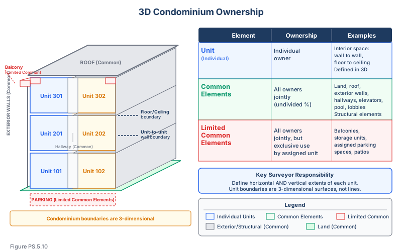
A condominium is a form of property ownership where individual units are privately owned and the common areas (land, hallways, parking, amenities) are jointly owned by all unit owners through an association. The surveyor's role is to define the three-dimensional boundaries of each unit and the common elements.
What makes condominiums unique for surveyors:
- Boundaries are three-dimensional (floors, walls, and ceilings define ownership)
- Units may not touch the ground (upper-floor units have no direct land boundary)
- Common elements are shared ownership, not individual parcels
- The legal framework is governed by state condominium statutes
- Creation requires a declaration, bylaws, and condominium plat
Components of a Condominium Plat
Site plan:
- Shows the overall property boundary with bearings, distances, and curve data
- Building footprints and their relationship to property lines
- Common area improvements (parking, pools, landscaping, walkways)
- Easements and rights of way
- Setback lines and zoning compliance
Floor plans for each level:
- Horizontal dimensions of each unit
- Unit boundaries (typically interior wall faces or centerline of party walls)
- Unit numbers and identifiers
- Common element areas on each floor (hallways, stairwells, elevators, mechanical rooms)
- Limited common elements assigned to specific units (balconies, storage units, parking spaces)
Vertical information:
- Finished floor elevations for each level
- Ceiling heights for each unit
- Vertical extent of unit ownership (floor-to-ceiling or slab-to-slab)
- Building height relative to the vertical datum
Required legal elements:
- Unit ownership percentages (each unit's share of common elements)
- Description of common elements
- Description of limited common elements
- Reference to the declaration and bylaws
Three-Dimensional Boundary Definition
Condominium unit boundaries are defined differently than traditional land boundaries:
| Boundary Element | Common Definition Methods |
|---|---|
| Horizontal (walls) | Interior face of drywall, centerline of party walls, or exterior face of framing |
| Vertical (floors) | Upper surface of structural slab or upper surface of finished floor |
| Vertical (ceilings) | Lower surface of structural slab above or lower surface of finished ceiling |
| Building envelope | Exterior face of exterior walls (varies by declaration) |
The declaration controls: The condominium declaration (master deed) defines exactly what constitutes each unit and what constitutes common elements. The surveyor must read the declaration carefully before preparing the plat.
Common Elements vs. Limited Common Elements
Common elements (owned by all unit owners):
- Land underlying the building
- Building structure (foundations, roof, exterior walls, structural elements)
- Hallways, stairways, elevators
- Mechanical systems (HVAC, plumbing, electrical to the point of unit connection)
- Parking areas (unless assigned)
- Recreational facilities
- Landscaping and grounds
Limited common elements (reserved for use by specific unit owners):
- Assigned parking spaces
- Balconies and patios
- Storage units
- Individual HVAC equipment (window units, heat pumps)
- Exclusive-use portions of common areas adjacent to specific units
Condominium Associations
The condominium association (homeowner association for condominiums) is responsible for:
- Managing and maintaining common elements
- Enforcing the declaration, bylaws, and rules
- Collecting assessments from unit owners
- Insuring common elements
- Making decisions about modifications and improvements
Surveyor interaction with associations:
- Associations may commission surveys for encroachment disputes between units
- Boundary surveys may be needed when the building relationship to property lines is in question
- As-built surveys verify that construction matches the approved condominium plat
- Amendments to the condominium plat require a surveyor to prepare the amended plat
Zoning Ordinances
Zoning ordinances are local government regulations that control land use and development. The surveyor must understand zoning because:
- ALTA surveys may require zoning classification and setback identification (Table A, Item 6)
- Subdivision plats must comply with zoning dimensional standards
- Site plans for development projects must show zoning compliance
- Encroachments into setbacks create compliance issues that surveys identify
Common zoning classifications:
| Classification | Typical Designation | Description |
|---|---|---|
| Single-family residential | R-1, RS | Detached single-family homes |
| Multi-family residential | R-3, RM | Apartments, townhouses, condominiums |
| Commercial | C-1, C-2 | Retail, office, and service uses |
| Industrial | I-1, M-1 | Manufacturing, warehousing, distribution |
| Agricultural | A-1, AG | Farming, rural uses |
| Mixed use | MU, MX | Combination of residential and commercial |
| Planned development | PD, PUD | Flexible zoning for unified developments |
Zoning Dimensional Standards
Each zoning classification specifies dimensional requirements:
| Standard | Definition |
|---|---|
| Front setback | Minimum distance from the front property line to the building |
| Side setback | Minimum distance from the side property line to the building |
| Rear setback | Minimum distance from the rear property line to the building |
| Maximum building height | Maximum height of structures (measured differently by jurisdiction) |
| Maximum lot coverage | Maximum percentage of the lot covered by impervious surface |
| Floor Area Ratio (FAR) | Maximum ratio of building floor area to lot area |
| Minimum lot area | Smallest permissible lot size in the zone |
| Minimum lot width | Narrowest permissible lot width at the front building line |
Setback measurement:
- Setbacks are measured from the property line, not the street centerline (unless otherwise specified)
- Some jurisdictions measure from the right-of-way line
- Overhangs, eaves, and projections may be permitted to encroach into setbacks to a limited extent
- Corner lots may have two front setbacks or a front and a street-side setback
Deed Restrictions and CC&Rs
Deed restrictions are private agreements that restrict land use beyond what zoning requires.
Covenants, Conditions, and Restrictions (CC&Rs):
- Recorded documents that run with the land
- Created by the original subdivider or developer
- Apply to all lots within the subdivision or development
- Enforced by the homeowner association or by individual property owners
- May be more restrictive than zoning (larger setbacks, use limitations, architectural standards)
- Cannot be less restrictive than zoning (zoning sets the floor)
Common CC&R provisions affecting surveys:
- Building setback lines (may exceed zoning setbacks)
- Maximum building height
- Minimum building size
- Fence height and location restrictions
- Accessory structure limitations
- Driveway and parking restrictions
- Architectural review requirements
Common wrong path — assuming zoning overrides CC&Rs (or vice versa). Zoning and CC&Rs are independent layers of restriction, and the more restrictive of the two controls. CC&Rs can never make land use less restrictive than zoning (zoning is the floor), but they can make it more restrictive (larger setbacks, tighter height limits, architectural standards). A zoning side-setback of 10 ft combined with a CC&R side-setback of 15 ft means the effective side setback is 15 ft, not 10 ft. Students sometimes answer "zoning governs" because zoning is "law" and CC&Rs are "private," forgetting that both are enforceable and the stricter wins. On an ALTA survey, both zoning and CC&R setbacks should be plotted, and any encroachment into either is noted as a compliance issue. Exam questions frequently test this by describing a structure that meets zoning but violates the CC&R; the correct response is to flag the CC&R violation even though zoning is technically satisfied.
Quick retrieval check — try before reading on.
▶A single-family residence is built 12 ft from the front property line. The zoning requires a 15 ft front setback; the recorded CC&Rs require a 20 ft front setback. Does the building comply with applicable land-use restrictions?
No — it violates both. Under zoning, the building is 3 ft into the required 15 ft front setback. Under the CC&Rs, the building is 8 ft into the required 20 ft front setback. Either violation independently makes the structure non-compliant. The CC&R provides the more restrictive standard (20 ft), so the "true" required front setback at this property is 20 ft, and the building violates that setback by 8 ft. On an ALTA survey, the surveyor should:
- Plot the zoning setback line (15 ft) and the CC&R setback line (20 ft) if both apply to the property
- Show the building position relative to both
- Note in the surveyor's comments that the structure does not comply with either zoning or the CC&Rs
- Leave the remedy (variance, zoning relief, CC&R amendment, demolition, encroachment agreement) to the client's attorney and local officials
The CC&Rs must be recorded and must apply to this parcel to be enforceable — a surveyor should verify this through the title commitment or recorded documents, not rely solely on the client's description.
Relationship Between Zoning and Deed Restrictions
| Characteristic | Zoning | Deed Restrictions |
|---|---|---|
| Authority | Government (police power) | Private agreement |
| Enforcement | Government officials | Association or property owners |
| Amendment | Legislative process (public hearing) | Agreement of affected owners |
| Application | All properties in the zone | Specific subdivision or development |
| Relationship | Sets minimum standards | May exceed but not reduce zoning |
| Duration | Continues until rezoned | May have expiration dates |
| Surveyor's role | Report classification and setbacks | Plot any restrictions that can be located |
Nonconforming Uses and Variances
Nonconforming use (grandfathering):
- A lawful use that existed before the current zoning was adopted
- May continue but typically cannot be expanded or resumed after abandonment
- Surveyors may need to document the extent of nonconforming uses
Variance:
- Permission to deviate from a specific zoning requirement
- Requires a showing of hardship
- Granted by the board of zoning appeals or equivalent body
- Does not change the zoning classification
Special exception / conditional use:
- A use permitted in a zoning district subject to specific conditions
- Requires approval with conditions that must be met
- The survey may need to document compliance with those conditions
Exam Tips
- Condominium boundaries are three-dimensional -- floors, walls, and ceilings define unit ownership, not just a footprint on the ground
- The condominium declaration (not the plat) defines what constitutes a unit versus common elements -- the plat depicts what the declaration describes
- Limited common elements are common elements assigned for exclusive use by specific unit owners (balconies, assigned parking)
- CC&Rs can be more restrictive than zoning but never less restrictive -- zoning sets the minimum floor
- Setbacks are measured from the property line (or right-of-way line), not the street centerline
- ALTA Table A Item 6(a) requires reporting zoning classification and setbacks; Item 6(b) requires a compliance determination
- Floor Area Ratio (FAR) = total building floor area divided by total lot area -- know this definition
- Nonconforming uses were legal when established but do not meet current zoning -- they may continue but generally cannot expand
- The surveyor reports zoning and CC&R information but does not render legal opinions on compliance -- the surveyor states facts and measurements
Related Test Topics
- ALTA/NSPS surveys and Table A items (Topic 5.1)
- Subdivision surveys and platting (Topic 5.9)
- Boundary surveys for property lines (Topic 5.5)
- Legal descriptions for condominium units (Module 1, Topic 1.9)
- Easement rights (Module 1, Topic 1.6)
- Consultation services and development feasibility (Topic 5.12)
Further Reading
Authoritative sources for deeper study
2021 ALTA/NSPS Land Title Survey Standards — Current minimum standard detail requirements for ALTA/NSPS land title surveys.
Brown's Boundary Control and Legal Principles (7th Ed., Robillard & Wilson) — Standard textbook on boundary law, evidence hierarchy, and retracement.
Wattles, Writing Legal Descriptions (1976) — Gold-standard reference on metes-and-bounds, sectional, and combination descriptions.
Last updated: 2026-04-17