PS Exam Preparation
Comprehensive preparation for the NCEES Principles and Practice of Surveying (PS) exam. 5 modules covering all 5 exam domains with 50 in-depth topics.
Module 1: Legal Principles
Module 2: Professional Survey Practices
Module 3: Standards & Specifications
Module 4: Business Practices
Module 5: Areas of Practice
FEMA Specifications & Instructions
Learning Objectives
After completing this topic, you should be able to:
- Explain the purpose of the National Flood Insurance Program (NFIP)
- Identify and interpret FEMA flood zone designations (A, AE, V, VE, X, etc.)
- Define Special Flood Hazard Area (SFHA) and its significance
- Explain Base Flood Elevation (BFE) and its role in floodplain management
- Read and interpret a Flood Insurance Rate Map (FIRM)
- Describe the surveyor's role in flood hazard determinations
Overview
The Federal Emergency Management Agency (FEMA) administers the National Flood Insurance Program (NFIP), which provides federally backed flood insurance to property owners in participating communities. The NFIP requires communities to adopt and enforce floodplain management regulations in exchange for access to affordable flood insurance.
For land surveyors, FEMA specifications intersect with practice in two primary ways: determining whether a property lies within a Special Flood Hazard Area (SFHA) and preparing Elevation Certificates that document a structure's elevation relative to the Base Flood Elevation. The PS exam tests your understanding of flood zone designations, FIRM map interpretation, and the surveyor's role in the NFIP framework.
Key Concepts
The National Flood Insurance Program (NFIP)
The NFIP was established by the National Flood Insurance Act of 1968 and significantly expanded by the Flood Disaster Protection Act of 1973. Its three core components:
- Flood insurance: Federally backed insurance available to property owners in participating communities
- Floodplain management: Communities must adopt regulations that reduce future flood damage as a condition of participation
- Flood hazard mapping: FEMA produces Flood Insurance Rate Maps (FIRMs) that identify areas at risk of flooding
Key Mandate: Properties in SFHAs that have federally backed mortgages are required to carry flood insurance. This requirement is what drives the demand for flood zone determinations and elevation certificates.
Flood Insurance Rate Maps (FIRMs)
A FIRM is the official map produced by FEMA that delineates flood hazard areas within a community. FIRMs show:
- Flood zone designations for all areas within the community
- Base Flood Elevations (BFEs) where determined
- Floodway boundaries where applicable
- Community panel number and effective date
- Cross-section locations used in the Flood Insurance Study (FIS)
FIRMs are organized by community and panel number. A single community may have many panels at varying scales. The map panel number, community number, effective date, and map suffix are essential identifying information that must appear on Elevation Certificates and flood zone determinations.
Digital FIRMs (DFIRMs): Modern FIRMs are produced digitally and available through FEMA's Map Service Center. DFIRMs use GIS-based mapping and provide more precise delineation than older paper FIRMs.
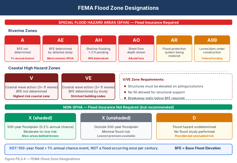
Flood Zone Designations
FEMA uses letter designations to classify flood risk areas. Understanding these is essential for the PS exam.
Special Flood Hazard Areas (SFHAs) -- High Risk:
These zones have a 1% or greater annual chance of flooding (the "100-year flood"). Properties in these zones with federal mortgages must carry flood insurance.
| Zone | Description | BFE Determined? |
|---|---|---|
| A | 100-year floodplain; BFE not determined | No |
| AE | 100-year floodplain; BFE determined by detailed study | Yes |
| AH | Areas of shallow flooding (1-3 ft) with BFE; usually ponding areas | Yes |
| AO | Areas of shallow flooding (1-3 ft) with depth shown; usually sheet flow | Depth shown |
| AR | Areas where a previously accredited flood protection system is being restored | Varies |
| A99 | Areas protected by federal flood protection system under construction | No |
Coastal High Hazard Areas -- Highest Risk:
These zones are subject to storm-driven wave action in addition to flooding. Coastal construction standards are significantly more stringent.
| Zone | Description | BFE Determined? |
|---|---|---|
| V | Coastal flood zone with velocity wave action; BFE not determined | No |
| VE | Coastal flood zone with velocity wave action; BFE determined | Yes |
Non-Special Flood Hazard Areas -- Moderate to Low Risk:
| Zone | Description | Insurance Required? |
|---|---|---|
| X (shaded) | 500-year floodplain (0.2% annual chance) or areas protected by levees | No (but recommended) |
| X (unshaded) | Areas outside the 500-year floodplain; minimal flood risk | No |
| B | Legacy designation equivalent to shaded Zone X | No |
| C | Legacy designation equivalent to unshaded Zone X | No |
| D | Areas with possible but undetermined flood hazards; no analysis performed | No |
Key FEMA Definitions
Base Flood: The flood having a 1% chance of being equaled or exceeded in any given year (commonly called the "100-year flood"). This does not mean it occurs once every 100 years -- it means there is a 1% probability in any single year.
Base Flood Elevation (BFE): The computed elevation to which floodwater is anticipated to rise during the base flood. BFE is shown on FIRMs in zones AE and VE and is the benchmark against which a structure's elevation is measured.
Special Flood Hazard Area (SFHA): Any area shown on a FIRM as Zone A, AE, AH, AO, AR, A99, V, or VE. These are all areas with a 1% or greater annual chance of flooding. The SFHA determination drives insurance requirements.
Floodway: The channel of a river or other watercourse and the adjacent land areas that must be reserved to discharge the base flood without cumulatively increasing the water surface elevation more than a designated height (typically 1 foot). The floodway is the most hazardous portion of the floodplain.
Flood Insurance Study (FIS): The technical report prepared by FEMA that provides detailed flood risk data for a community, including flood profiles, floodway data tables, and the basis for BFE determinations.
The Surveyor's Role in Flood Hazard Determination
Surveyors contribute to the FEMA/NFIP process in several ways:
Flood Zone Determination:
- Determining whether a property or structure is within an SFHA by referencing the FIRM
- This may be requested as ALTA/NSPS Table A Item 3
- The surveyor locates the property on the FIRM and identifies the applicable flood zone(s)
- If the property lies in multiple zones, all zones must be identified
Elevation Certificates:
- Preparing FEMA Elevation Certificates that document a structure's elevation relative to the BFE (covered in detail in Topic 3.5)
- This requires establishing vertical control and measuring specific building elevations
Letters of Map Amendment (LOMA) and Letters of Map Revision (LOMR):
- Surveyors provide the technical data supporting requests to FEMA to remove a property from the SFHA
- A LOMA is typically based on demonstrating that the natural ground is above the BFE
- A LOMR is based on changes in flood conditions (e.g., new flood control infrastructure)
- The surveyor provides an Elevation Certificate or other survey data as the basis for the request
FIRM Interpretation for Surveyors
When interpreting a FIRM, the surveyor must identify:
- Community and panel number -- Ensures the correct map is being referenced
- Effective date and suffix -- FIRMs are periodically updated; the effective date determines which version is current
- Flood zone(s) covering the subject property
- BFE -- If the property is in an AE or VE zone, the BFE is shown as a contour line or in the Floodway Data Table
- Floodway boundary -- If the property is within or adjacent to a regulatory floodway
- Zone boundary location relative to the property -- When a zone boundary crosses a property, the surveyor must determine which portions are in which zones
Interpolating BFE: When a property lies between two BFE contour lines on the FIRM, the surveyor may need to interpolate the BFE at the specific property location using the flood profiles in the FIS.
Common wrong path — "100-year flood means every 100 years." The "100-year flood" is a flood with a 1% annual exceedance probability — meaning in any given year, there is a 1-in-100 chance of a flood at or above this level. It does NOT mean the flood occurs once every 100 years. Two consecutive 100-year floods are possible (in fact, more probable than people expect). The probability of experiencing at least one 100-year flood over a 30-year mortgage is about 26%, not 30%. Students and the public often misunderstand this; exam questions specifically test whether you know the correct interpretation. The "recurrence interval" language is statistically correct but commonly misread. Always describe the base flood as "1% annual chance of flooding" rather than "happens every 100 years" to avoid the confusion.
Quick retrieval check — try before reading on.
▶A home is built in a Zone AE with a Base Flood Elevation of 12.0 ft NAVD88. The lowest floor is at elevation 13.5 ft NAVD88 (1.5 ft of freeboard). Over a 30-year period, what is the approximate probability that the home will experience a flood at or above the BFE?
The annual probability of the base flood is 1% (by definition). The probability of experiencing at least one base-flood-or-greater event over 30 years is:
.
So there is roughly a 1-in-4 chance over 30 years of a flood reaching the BFE. The 1.5 ft of freeboard provides a safety margin for floods somewhat above the BFE, but does not change the probability of reaching the BFE itself — only the probability of water reaching the floor. This is why federal rules require flood insurance for properties in SFHAs with federal mortgages: the cumulative risk over the life of the mortgage is substantial. A surveyor who explains flood risk to clients should never use the "once every 100 years" phrasing — it gives false comfort.
Relationship Between Flood Zone and Insurance
| Flood Zone | SFHA? | Flood Insurance Required? | BFE Available? |
|---|---|---|---|
| A, AE, AH, AO, AR, A99 | Yes | Yes (with federal mortgage) | Varies by subzone |
| V, VE | Yes | Yes (with federal mortgage) | Varies by subzone |
| X (shaded) | No | No (recommended) | No |
| X (unshaded) | No | No | No |
| D | No | No (recommended) | No |
Exam Tips
- An SFHA is any A or V zone -- all A-prefixed and V-prefixed zones are SFHAs where flood insurance is mandatory for federally backed mortgages
- The "100-year flood" is a 1% annual chance event, NOT a flood that happens once per century -- this is a classic exam trick
- Zone X replaced legacy zones B and C on modern FIRMs; know both designations
- BFEs are determined in AE and VE zones but NOT in unnumbered A and V zones -- this distinction matters for Elevation Certificates
- The floodway is the most restrictive area within the SFHA -- development in the floodway is generally prohibited or severely restricted
- Table A Item 3 on an ALTA/NSPS survey triggers a flood zone determination -- the surveyor must reference the FIRM and show the zone
- A LOMA removes a property from the SFHA based on natural ground elevation; a LOMR reflects changed flood conditions -- know the difference
- Zone D means "undetermined risk," not "no risk" -- the community has not been studied
- The surveyor determines the flood zone from the FIRM; the surveyor does not determine flood insurance rates
Related Test Topics
- FEMA Elevation Certificates (Topic 3.5)
- Datums for FEMA Compliance (Topic 3.6)
- ALTA/NSPS Standards and Table A Item 3 (Topic 3.2)
- Vertical control and benchmark establishment (Module 5 -- Areas of Practice)
- Professional liability for flood zone determinations (Module 2)
Further Reading
Authoritative sources for deeper study
FEMA Elevation Certificate (Form FF-206) — Official form and instructions for NFIP elevation certifications.
FGDC Geospatial Positioning Accuracy Standards — National standard for positional accuracy reporting (NSSDA).
NOAA Manual NOS NGS 5 — State Plane Coordinate System of 1983 — Definitive NGS reference for SPCS83 zone constants, projections, and conversions.
Last updated: 2026-04-17