PS Exam Preparation
Comprehensive preparation for the NCEES Principles and Practice of Surveying (PS) exam. 5 modules covering all 5 exam domains with 50 in-depth topics.
Module 1: Legal Principles
Module 2: Professional Survey Practices
Module 3: Standards & Specifications
Module 4: Business Practices
Module 5: Areas of Practice
Geospatial Positioning Accuracy Standards
Learning Objectives
After completing this topic, you should be able to:
- Explain the purpose and structure of the FGDC Geospatial Positioning Accuracy Standards
- Describe the National Standard for Spatial Data Accuracy (NSSDA) methodology
- Calculate horizontal and vertical accuracy from RMSE values
- Explain accuracy classification systems for geodetic control
- Understand accuracy reporting conventions at the 95% confidence level
- Compare NSSDA to NMAS and explain why NSSDA was developed
- Apply accuracy standards to surveying projects and deliverables
Overview
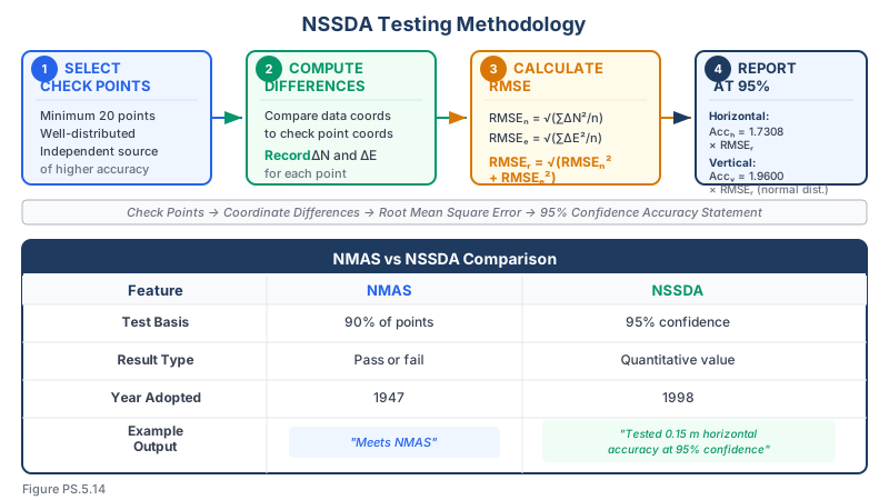
The Federal Geographic Data Committee (FGDC) Geospatial Positioning Accuracy Standards provide a modern, statistically rigorous framework for evaluating and reporting the positional accuracy of geospatial data. The most widely applied component is the National Standard for Spatial Data Accuracy (NSSDA), which replaced NMAS for federal geospatial data production. Unlike the binary pass/fail approach of NMAS, NSSDA requires reporting the actual accuracy achieved, expressed in ground units at the 95% confidence level.
The PS exam tests your understanding of FGDC standards because they represent the current standard of practice for accuracy assessment in surveying and mapping.
Key Concepts
FGDC Framework
The Federal Geographic Data Committee (FGDC) publishes a family of accuracy standards organized into three parts:
Part 1: Reporting Methodology
- Establishes the general framework for accuracy reporting
- Defines the 95% confidence level as the reporting standard
- Provides the statistical methodology for computing accuracy from test data
Part 2: Standards for Geodetic Networks (FGCS Standards)
- Accuracy standards for horizontal and vertical geodetic control
- Classification by accuracy level
- Network adjustment and testing requirements
Part 3: National Standard for Spatial Data Accuracy (NSSDA)
- Accuracy standard for maps, digital geospatial data, and survey products
- Testing methodology using independent check points
- Reporting format for accuracy values
National Standard for Spatial Data Accuracy (NSSDA)
NSSDA is the primary accuracy standard for geospatial data in the United States.
Key principles:
- Accuracy is reported in ground units (feet or meters), not map units
- All accuracy values are reported at the 95% confidence level
- Accuracy is computed from Root Mean Square Error (RMSE) of test points
- Independent check points are used for testing (not the same points used to create the data)
- Both horizontal and vertical accuracy are addressed separately
RMSE Calculations
Root Mean Square Error (RMSE) is the fundamental statistic used in NSSDA:
RMSE in one dimension (e.g., vertical):
RMSE_z = sqrt[ sum(z_data - z_check)^2 / n ]
Where:
- z_data = elevation from the dataset being tested
- z_check = elevation from the independent check source
- n = number of check points
RMSE in two dimensions (horizontal):
RMSE_x = sqrt[ sum(x_data - x_check)^2 / n ] RMSE_y = sqrt[ sum(y_data - y_check)^2 / n ] RMSE_r = sqrt[ RMSE_x^2 + RMSE_y^2 ]
Where RMSE_r is the horizontal RMSE (radial).
Converting RMSE to 95% Confidence
Horizontal accuracy at 95% confidence:
Accuracy_horizontal = 1.7308 x RMSE_r
This assumes errors are normally distributed and equal in both x and y directions (circular error). The factor 1.7308 converts from RMSE_r to the 95% confidence level.
If RMSE_x and RMSE_y are significantly different, the circular normal assumption is less valid, but NSSDA still uses this formula for simplicity.
Vertical accuracy at 95% confidence:
Accuracy_vertical = 1.9600 x RMSE_z
The factor 1.9600 is the z-value for 95% confidence in a normal distribution (one-dimensional).
NSSDA Testing Methodology
Step 1: Collect independent check points
- Minimum of 20 check points (NSSDA requirement)
- Check points must be well-defined, clearly identifiable features
- Check points must be surveyed using methods at least 3 times more accurate than the data being tested
- Check points should be distributed across the project area
Step 2: Compare data positions to check point positions
- For each check point, compute the difference between the data position and the check position
- Record x, y, and z differences separately
Step 3: Compute RMSE values
- RMSE_x, RMSE_y, and RMSE_z from the differences
- RMSE_r for horizontal accuracy
Step 4: Convert to 95% confidence
- Horizontal: Accuracy = 1.7308 x RMSE_r
- Vertical: Accuracy = 1.9600 x RMSE_z
Step 5: Report accuracy
- State the accuracy values in ground units with the confidence level
- Example: "Tested 3.5 feet horizontal accuracy at 95% confidence level"
- Example: "Tested 1.2 feet vertical accuracy at 95% confidence level"
Common wrong path — applying the horizontal factor to vertical data (or vice versa). The two conversion factors in NSSDA are different because they apply to different statistical distributions. Horizontal accuracy uses 1.7308 (derived from a 2D circular normal distribution at 95%). Vertical accuracy uses 1.9600 (the 1D normal z-value at 95%). Students frequently mix them up — multiplying horizontal RMSE by 1.96 to get horizontal 95% accuracy, or multiplying vertical RMSE by 1.7308. The first produces a slightly too-high horizontal accuracy (≈ +13%), the second produces a slightly too-low vertical accuracy (≈ −12%). Both are wrong answers on the exam. Memorize the pairing: 1.7308 for horizontal (2D, circular), 1.9600 for vertical (1D, linear). And never apply either factor to an already-at-95% accuracy value — the factors convert RMSE to 95%, not 95% to something else.
Quick retrieval check — try before reading on.
▶An airborne LiDAR dataset has RMSE_x = 0.35 ft, RMSE_y = 0.40 ft, RMSE_z = 0.55 ft, based on 25 check points. What are the horizontal and vertical accuracies at 95% confidence?
Horizontal: RMSE_r = √(0.35² + 0.40²) = √(0.1225 + 0.1600) = √0.2825 = 0.5315 ft. Multiply by 1.7308: horizontal accuracy at 95% = 0.5315 × 1.7308 = 0.92 ft.
Vertical: Multiply RMSE_z by 1.9600: vertical accuracy at 95% = 0.55 × 1.9600 = 1.08 ft.
Report as: "Tested 0.92 ft horizontal accuracy at the 95% confidence level; tested 1.08 ft vertical accuracy at the 95% confidence level." If you had applied 1.96 to horizontal instead, you'd report 1.04 ft (about 13% too high) — a wrong answer on the exam. Also note: the minimum 20 check points was exceeded (25) and the check points must have been independently surveyed at 3× the accuracy of the LiDAR for the test to be valid.
Example Calculation
Given 25 check points with the following computed statistics:
- RMSE_x = 0.45 feet
- RMSE_y = 0.52 feet
- RMSE_z = 0.38 feet
Horizontal RMSE: RMSE_r = sqrt(0.45^2 + 0.52^2) = sqrt(0.2025 + 0.2704) = sqrt(0.4729) = 0.687 feet
Horizontal accuracy at 95% confidence: Accuracy_horizontal = 1.7308 x 0.687 = 1.19 feet
Vertical accuracy at 95% confidence: Accuracy_vertical = 1.9600 x 0.38 = 0.74 feet
Reported as: "Tested 1.19 feet horizontal accuracy at the 95% confidence level, compiled to meet 2-foot horizontal accuracy at the 95% confidence level." "Tested 0.74 feet vertical accuracy at the 95% confidence level, compiled to meet 1-foot vertical accuracy at the 95% confidence level."
FGDC Accuracy Standards for Geodetic Control
For geodetic control networks, FGDC Part 2 defines accuracy in terms of the 95% confidence region:
Horizontal accuracy classifications:
| Accuracy Class | 95% Confidence (local) | Typical Application |
|---|---|---|
| 1-mm | 1 mm | Deformation monitoring, high-precision scientific |
| 2-mm | 2 mm | High-order geodetic control |
| 5-mm | 5 mm | Primary geodetic control |
| 1-cm | 1 cm | Geodetic densification |
| 2-cm | 2 cm | Survey-grade GNSS, ALTA surveys |
| 5-cm | 5 cm | Mapping-grade GNSS |
| 1-dm | 10 cm | GIS feature collection |
| 2-dm | 20 cm | Resource-grade GNSS |
| 5-dm | 50 cm | Recreation-grade GPS |
| 1-m | 1 m | Navigation |
Network accuracy vs. local accuracy:
- Network accuracy -- The accuracy of a point position relative to the NSRS datum (geodetic accuracy)
- Local accuracy -- The accuracy of a point position relative to other directly connected points (relative accuracy)
- Both are expressed at the 95% confidence level
- For most surveying applications, local accuracy is the more relevant measure
Vertical Accuracy Classification
| Classification | Typical RMSE_z | 95% Accuracy | Application |
|---|---|---|---|
| 1-cm vertical | 0.5 cm | 1 cm | Precise leveling |
| 2-cm vertical | 1 cm | 2 cm | First-order leveling |
| 5-cm vertical | 2.5 cm | 5 cm | Second-order leveling |
| 10-cm vertical | 5 cm | 10 cm | Third-order leveling, GNSS |
| 25-cm vertical | 12.7 cm | 25 cm | Topographic mapping |
| 50-cm vertical | 25.5 cm | 50 cm | Regional mapping |
NGS Accuracy Reporting
The National Geodetic Survey reports accuracy on published datasheets using the FGDC framework:
- Horizontal accuracy in meters at 95% confidence (network and local)
- Vertical accuracy in meters at 95% confidence
- These values reflect the accuracy of the published coordinates relative to the NSRS
Accuracy vs. Precision
These terms are frequently confused but have distinct meanings:
| Term | Definition |
|---|---|
| Accuracy | Closeness of a measured value to the true value |
| Precision | Closeness of repeated measurements to each other |
| Bias | Systematic offset between measured and true values |
A survey can be precise but not accurate (consistently wrong by the same amount). NSSDA measures accuracy, not just precision, because it compares to independently determined "true" positions.
Relationship to Project Specifications
When specifying accuracy requirements for a survey or mapping project:
Using NSSDA:
- Specify the required horizontal and vertical accuracy at 95% confidence
- Example: "Horizontal accuracy shall be 0.50 feet at the 95% confidence level"
- The surveyor must then achieve RMSE_r less than or equal to 0.50/1.7308 = 0.289 feet
Using NMAS (for comparison):
- Specify the map scale and contour interval
- Accuracy is implied by the standard (1/30 inch horizontal, 1/2 contour interval vertical)
- Pass/fail determination
Best practice:
- Specify accuracy in ground units at 95% confidence (NSSDA approach)
- This is independent of map scale and directly meaningful for field work
- Allows the data to be used at any display scale without ambiguity
ASPRS Positional Accuracy Standards
The American Society for Photogrammetry and Remote Sensing (ASPRS) publishes its own accuracy standards for digital geospatial data (updated in 2014):
- Uses RMSE-based methodology consistent with NSSDA
- Defines accuracy classes based on RMSE thresholds
- Applicable to orthoimagery, digital planimetric data, digital elevation data, and LiDAR
- Horizontal accuracy classes are defined by RMSE_x and RMSE_y values
- Vertical accuracy addresses both vegetated and non-vegetated terrain
Exam Tips
- Memorize the conversion factors: Horizontal accuracy at 95% = 1.7308 x RMSE_r; Vertical accuracy at 95% = 1.9600 x RMSE_z
- NSSDA requires a minimum of 20 check points, independently surveyed at 3 times the accuracy of the data being tested
- RMSE_r = sqrt(RMSE_x^2 + RMSE_y^2) -- be ready to compute this from given data
- NSSDA reports accuracy in ground units at 95% confidence; NMAS reports accuracy as a function of map scale at an implied 90% threshold
- "Network accuracy" is relative to the NSRS datum; "local accuracy" is relative to nearby points -- know the difference
- Accuracy measures closeness to truth; precision measures consistency of repeated measurements -- they are not the same thing
- The FGDC 2-cm accuracy class corresponds to the ALTA/NSPS RPP standard of 2 cm (at close range)
- Always check whether an exam question asks for RMSE or 95% accuracy -- they are different values
- If given RMSE values, multiply by the appropriate factor to get 95% accuracy; if given 95% values, divide to get RMSE
Related Test Topics
- US National Map Accuracy Standards (Topic 5.13)
- Control networks and geodetic surveys (Topic 5.2)
- Datums and reference frames (Topic 5.3)
- ALTA/NSPS surveys and RPP (Topic 5.1)
- Topographic mapping accuracy (Topic 5.7)
- Hydrographic and remote sensing accuracy (Topic 5.8)
Further Reading
Authoritative sources for deeper study
FGDC Geospatial Positioning Accuracy Standards — National standard for positional accuracy reporting (NSSDA).
Ghilani & Wolf, Adjustment Computations (5th Ed., 2010) — Authoritative treatment of least-squares adjustment for surveying networks.
Wolf & Ghilani, Elementary Surveying — Chapter on theory of errors and error propagation.
Last updated: 2026-04-17