PS Exam Preparation
Comprehensive preparation for the NCEES Principles and Practice of Surveying (PS) exam. 5 modules covering all 5 exam domains with 50 in-depth topics.
Module 1: Legal Principles
Module 2: Professional Survey Practices
Module 3: Standards & Specifications
Module 4: Business Practices
Module 5: Areas of Practice
Controlling Elements & Hierarchy of Calls
Learning Objectives
After completing this topic, you should be able to:
- State the hierarchy of controlling elements (SICMoMe) from memory
- Apply the hierarchy to resolve conflicting deed calls
- Distinguish between natural and artificial monuments and their relative weight
- Explain the measurement hierarchy (distance, direction, area, coordinates)
- Define what makes a monument legally controlling
- Identify when the hierarchy may be overridden and by what authority
- Resolve exam-style scenarios involving conflicting elements
Overview
The hierarchy of controlling elements is the single most important legal framework in boundary surveying. When elements of a deed description conflict -- and they almost always do to some degree -- the surveyor must know which elements control. This hierarchy, developed through centuries of common law and codified in numerous court decisions, provides the rules for resolving those conflicts.
The hierarchy is commonly remembered by the mnemonic SICMoMe: Senior rights, Intent of the parties, Call for a survey, Monuments, Measurements. This is not merely a study aid -- it is the operational framework that every professional surveyor must apply daily.
The rules regarding the priority of calls are not arbitrary. They reflect longstanding judicial reasoning about which elements of a description are most reliable indicators of the true boundary location (Evidence and Procedures for Boundary Location, 6th Ed., Robillard & Wilson).
Key Concepts
The Hierarchy: SICMoMe
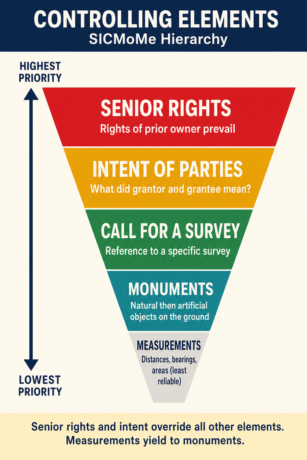
The controlling elements, in order of priority from highest to lowest:
| Priority | Element | Mnemonic | Description |
|---|---|---|---|
| 1 | Senior rights | S | The rights of the first grantee prevail |
| 2 | Intent of the parties | I | The paramount purpose of the deed |
| 3 | Call for a survey | C | Reference to a specific prior survey |
| 4 | Monuments | Mo | Physical objects called for in the deed |
| 5 | Measurements | Me | Distances, bearings, areas, coordinates |
1. Senior Rights (Highest Priority)
The doctrine of senior rights holds that the first party to receive a conveyance from a common grantor has the superior right. When a grantor conveys overlapping parcels, the senior grantee (first in time) prevails over the junior grantee (later in time).
Key principles:
- First in time, first in right (prior tempore, prior jure)
- The senior conveyance is measured first and the junior gets what remains
- Senior rights can only be defeated by valid unwritten rights (adverse possession, etc.)
- Senior rights apply to sequential conveyances from the same grantor
- A grantor cannot convey what has already been conveyed
Example: Owner X sells the north 100 feet to A on January 1, then sells the north 120 feet to B on March 1. A has the senior right to the north 100 feet. B gets only the 20-foot strip between A's boundary and the 120-foot line (if it exists).
2. Intent of the Parties
The intent of the parties at the time of the conveyance is the paramount consideration in deed interpretation (subject only to senior rights and valid unwritten rights). Intent is determined from:
- The deed language as a whole (not isolated phrases)
- The surrounding circumstances at the time of the conveyance
- The purpose of the transaction
- The conduct of the parties after the conveyance
Critical rules regarding intent:
- Intent is determined from the four corners of the deed when the language is clear
- When the language is ambiguous, extrinsic evidence may be considered
- The intent must be the intent at the time of the conveyance, not later intentions
- Intent controls over specific measurements when they conflict
- Specific intent controls over general intent
Example: A deed conveys "the Smith farm" and also gives a metes and bounds description. If the metes and bounds description excludes a portion of what was historically known as the Smith farm, the intent to convey the entire farm (as identified by the general description) may control over the specific measurements.
3. Call for a Survey
A call for a survey is a reference in the deed to a specific survey, plat, or map. When a deed references "as shown on the plat of Green Acres subdivision recorded in Book 5, Page 23," the plat becomes part of the deed and its details (monuments, dimensions, lot lines) are incorporated by reference.
Why calls for surveys rank high:
- They incorporate detailed information (monuments, measurements, relationships) that the deed itself may not contain
- They represent the parties' agreement to be bound by the survey
- They typically predate the deed and represent the foundation of the conveyance
- The plat shows relationships between lots that individual deed descriptions may not capture
Types of calls for surveys:
| Type | Example |
|---|---|
| Reference to recorded plat | "Lot 5 as shown on the plat recorded in Book 10, Page 50" |
| Reference to specific survey | "As surveyed by John Smith, PLS, in October 1965" |
| Reference to government survey | "The NW 1/4 of Section 12, T3N, R4W" |
| Reference to prior deed | "Being the same parcel conveyed to Jones by deed dated..." |
4. Monuments
Monuments are physical objects on the ground that are called for in the deed description. They are the primary means by which the written description is connected to the physical world. Monuments rank above measurements because they are fixed, tangible references that the parties could see and agree upon, while measurements are subject to error.
Three Requirements for a Controlling Monument
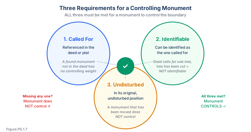
A monument controls only when it meets all three requirements:
- Called for -- The monument must be referenced in the deed or plat
- Identifiable -- The monument must be identifiable as the one called for
- Undisturbed -- The monument must be in its original, undisturbed position
If any one of these requirements is not met, the monument does not control:
| Scenario | Called For? | Identifiable? | Undisturbed? | Controlling? |
|---|---|---|---|---|
| Deed calls for iron pipe, found in place | Yes | Yes | Yes | Yes |
| Iron pipe found but not mentioned in deed | No | N/A | N/A | No |
| Deed calls for oak tree, tree has been cut | Yes | No | N/A | No |
| Deed calls for iron pipe, pipe found but moved | Yes | Yes | No | No |
| Deed calls for stone monument, matching stone found | Yes | Yes | Presumed yes | Probably yes |
Natural vs. Artificial Monuments
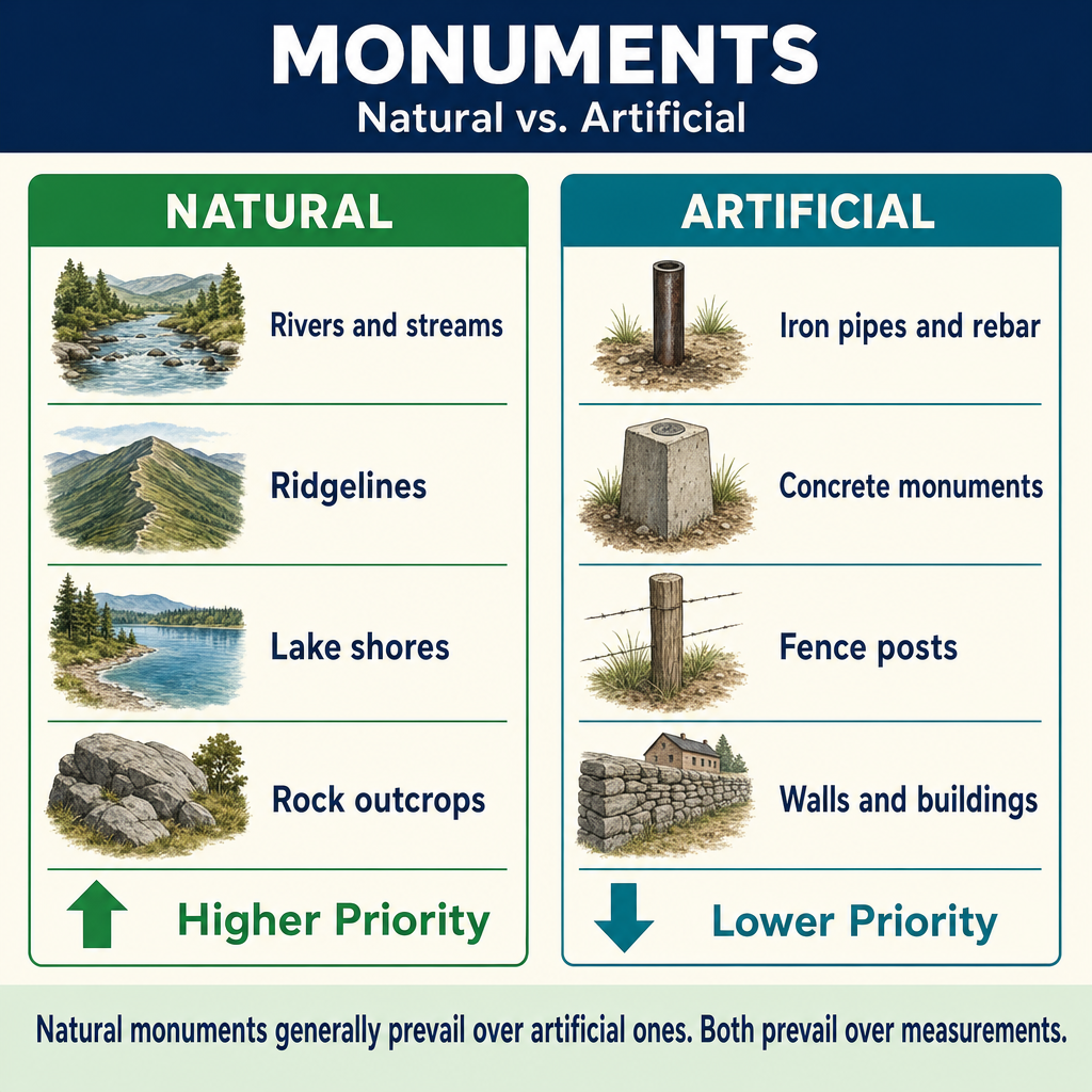
Within the monument category, natural monuments generally control over artificial monuments:
| Natural Monuments | Artificial Monuments |
|---|---|
| Rivers and streams | Iron pipes and rebar |
| Lakes and shorelines | Stone monuments |
| Ridgelines and hilltops | Fence posts and corners |
| Rock outcrops and boulders | Building corners |
| Trees (bearing/witness) | Road intersections |
| Bluffs and escarpments | Railroad markers |
Why natural monuments rank higher:
- They are more permanent and less likely to be disturbed
- They are more easily identifiable over long periods
- They are less susceptible to human tampering
- They provide unmistakable reference points
Exception: When the intent of the parties clearly refers to an artificial monument, the artificial monument may control over a nearby natural monument. The hierarchy is a guideline, not an absolute rule, and intent always plays a mediating role.
Record Monuments vs. Physical Monuments
A record monument is one that appears on the plat or in the deed but has no physical manifestation on the ground (or the physical monument has been destroyed). A physical monument is the actual object on the ground.
When a monument has been destroyed, the surveyor must attempt to recover its position through:
- Testimony of witnesses who saw it
- Relationships to other monuments
- Original survey measurements
- Photographs and prior survey records
5. Measurements (Lowest Priority)
Measurements are the lowest-ranking controlling element because they are the most susceptible to error. Note that the full evidence hierarchy also recognizes adjoiners (calls for adjoining properties) as a distinct category between monuments and measurements — see Topic 2.6 for the expanded hierarchy including adjoiners.
Within the measurement category, there is a sub-hierarchy:
| Priority | Measurement Type | Rationale |
|---|---|---|
| 1 | Direction (bearing/course) | Angular measurements are generally more reliable than linear measurements |
| 2 | Distance | Subject to chain/tape errors, slope corrections, temperature effects |
| 3 | Area | Computed from other measurements; circular dependency |
| 4 | Coordinates | Most recent addition; least historically reliable |
Why directions generally outrank distances (per Brown's Boundary Control, the majority-jurisdiction rule):
- Bearings define the direction of a line, which is less susceptible to cumulative error than chaining
- Distance measurements historically suffered from chain sag, slope errors, temperature effects, and broken-chain errors
- While magnetic bearings are subject to declination, the relative ranking reflects the majority of case law decisions
- In some specific historical surveys, the relative reliability may differ — but the general rule favors courses over distances
Why area ranks lowest among measurements:
- Area is computed from distances and directions, so it incorporates all their errors
- Area was historically approximated ("more or less")
- Area calls in deeds are often rounded or estimated
- Changing one boundary line changes the area, so area depends on the other elements
Coordinates traditionally rank lowest because:
- They are a relatively modern addition to deed descriptions
- They are derived from measurements and thus incorporate measurement errors
- They can be misidentified (wrong datum, wrong zone, transcription errors)
- Historical coordinates may reference superseded datums
Note: While coordinates traditionally rank lowest, modern geodetic coordinates referenced to well-defined datums (e.g., NAD 83, NATRF2022) are highly reliable. The traditional ranking reflects the historical unreliability of coordinates in older deeds, not a judgment about the quality of modern coordinate measurements.
When the Hierarchy May Be Modified
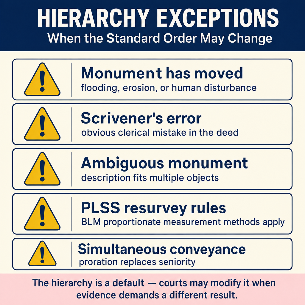
The hierarchy is not absolute. Courts have modified the standard order when:
- Clear intent of the parties indicates a different priority
- A monument has been disturbed or destroyed (dropping it from the hierarchy)
- The description contains a latent ambiguity that requires reanalysis
- Unwritten rights (adverse possession, acquiescence) override the written elements
- A gross error is apparent in a higher-ranking element
- The description was obviously prepared by someone who made a mistake in a specific call
The fundamental principle: The hierarchy exists to determine what the parties intended at the time of the conveyance. If applying the hierarchy mechanically would produce a result that is clearly contrary to the parties' intent, courts may adjust the application.
Common wrong path — giving an uncalled monument controlling weight. A classic exam trap: a scenario describes a rebar or stone found on the ground at an apparent boundary corner, but the deed does not reference any monument. Students' instinct is to treat found objects as monuments. That's wrong. A monument controls only when it is called for in the deed (or the plat incorporated by reference). An uncalled rebar is at best evidence of occupation or a prior surveyor's opinion — it may be useful corroboration but it has no hierarchical priority. The three-test rule is always: (1) called for, (2) identifiable, (3) undisturbed. Fail any one and the monument drops out of the hierarchy entirely; the boundary is then controlled by the next-available element (measurement, typically).
Quick retrieval check — try before reading on.
▶A 1890 metes-and-bounds deed calls for "N 60° E, 500 ft to a pine tree marked with three blazes." Today you find: (a) a stump of an old pine within 3 ft of the expected position with weathered blaze marks, (b) a rebar exactly 500.00 ft from the POB at precisely N 60° E. Which controls?
The stump. It satisfies all three monument tests — called for (the pine tree), identifiable (old pine + blaze marks match the deed), and undisturbed (it's in place, and the position falls within historical tolerance for an 1890 chain-and-compass survey). Under SICMoMe, monuments rank above measurements, so the stump controls over the measured bearing/distance even though those are more precise today. The rebar was not called for in the 1890 deed, so it has no monument priority — it's almost certainly a later surveyor's attempt to perpetuate the corner from the deed measurements, and if it lands 3 ft from the original stump, it's in the wrong place by monument control. Note your conclusion on the plat; document the stump as the controlling monument and explain your reasoning.
Practical Application
When a surveyor encounters conflicting calls in a deed, the resolution process is:
- Identify all calls in the deed description
- Classify each call by type (monument, measurement, etc.)
- Check for senior rights that might affect the boundary
- Determine the parties' intent from the deed as a whole
- Look for a called-for survey that might resolve the conflict
- Evaluate monuments -- are they called for, identifiable, and undisturbed?
- Fall back to measurements only when higher elements do not resolve the conflict
- Apply the measurement sub-hierarchy (distance > direction > area > coordinates)
- Document your reasoning for the resolution chosen
Exam Tips
- SICMoMe -- memorize this mnemonic and be able to apply it to any scenario
- Monuments MUST be: (1) called for, (2) identifiable, (3) undisturbed to control
- Natural monuments outweigh artificial monuments, but intent can override this
- Direction (bearing) generally outweighs distance under the majority-jurisdiction rule (Brown's Boundary Control); however, in federal/GLO surveys, distance often controls for original PLSS corners — know which regime governs the question before applying the rule
- Senior rights are the HIGHEST controlling element -- first in time, first in right
- The hierarchy determines intent, not the other way around -- but when the hierarchy produces an absurd result, intent may modify the application
- Area is almost never controlling -- it is the weakest measurement call
- A monument that is not called for in the deed has no controlling weight as a monument (though it may be evidence of something else)
- Look for exam questions that give you conflicting calls and ask which controls -- apply SICMoMe systematically
- Remember: the hierarchy exists to resolve conflicts. When elements agree, there is no conflict to resolve
Related Test Topics
- Searching and Evaluating Evidence (Topic 1.1)
- Parol Evidence (Topic 1.2)
- Sequential and Simultaneous Conveyances (Topic 1.8)
- Legal Descriptions (Topic 1.9)
- PLSS Perpetuation (Topic 1.10)
Further Reading
Authoritative sources for deeper study
Brown's Boundary Control and Legal Principles (7th Ed.), chapters on evidence hierarchy and weighing of conflicting calls.
Evidence and Procedures for Boundary Location (Robillard, Wilson, & Brown, 7th Ed.) — Practical treatise on collecting, weighing, and applying boundary evidence.
Wattles, Writing Legal Descriptions (1976) — Gold-standard reference on metes-and-bounds, sectional, and combination descriptions.
Clark, A Treatise on the Law of Surveying and Boundaries — Long-standing legal reference on boundary disputes and surveyor liability.
Last updated: 2026-04-17