PS Exam Preparation
Comprehensive preparation for the NCEES Principles and Practice of Surveying (PS) exam. 5 modules covering all 5 exam domains with 50 in-depth topics.
Module 1: Legal Principles
Module 2: Professional Survey Practices
Module 3: Standards & Specifications
Module 4: Business Practices
Module 5: Areas of Practice
Client & Interdisciplinary Communication
Learning Objectives
After completing this topic, you should be able to:
- Communicate survey findings effectively to clients with varying levels of technical knowledge
- Coordinate surveying services with engineers, architects, attorneys, and other professionals
- Prepare clear and complete survey reports, certifications, and professional opinions
- Manage client expectations throughout the project life cycle
- Communicate with the public about surveying matters
- Handle disagreements and difficult conversations professionally
Overview
Communication is the skill that connects technical competence to client satisfaction. A surveyor who performs flawless fieldwork but cannot explain the results clearly, coordinate effectively with design professionals, or manage client expectations will struggle professionally. The PS exam tests your understanding of professional communication principles -- not just what to communicate, but how, when, and to whom.
Surveying sits at the intersection of law, engineering, and property rights. The surveyor must communicate across all these disciplines, translating technical findings into language that attorneys, engineers, architects, title companies, government agencies, and property owners can understand and act upon.
Client Relations
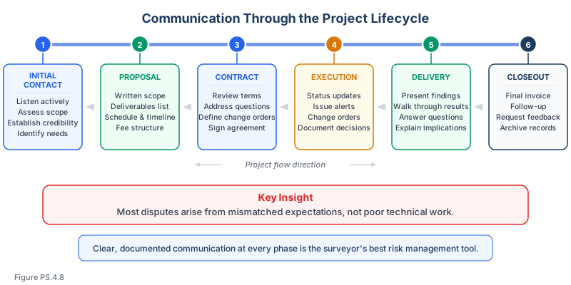
The Client Relationship Life Cycle
Effective client communication follows the project from first contact through closeout:
| Phase | Communication Goals | Key Activities |
|---|---|---|
| Initial contact | Understand client needs, establish credibility | Listen actively, ask clarifying questions, assess scope |
| Proposal | Clearly define what will be provided | Written scope, deliverables, schedule, fee |
| Contract execution | Establish mutual understanding of terms | Review contract together, address questions, sign |
| Project execution | Keep client informed of progress and issues | Status updates, change order discussions, milestone reports |
| Delivery | Present findings clearly, address questions | Deliver work product, walk through results, answer questions |
| Closeout | Ensure satisfaction, build long-term relationship | Final invoice, follow-up, request feedback |
Managing Client Expectations
Expectation management is perhaps the most important communication skill. Disputes often arise not from poor work, but from mismatched expectations:
| Situation | Poor Communication | Effective Communication |
|---|---|---|
| Boundary dispute discovered | Deliver plat showing conflict without explanation | Contact client immediately, explain the findings, discuss options before preparing the plat |
| Schedule delay | Deliver late with no advance notice | Notify client as soon as delay is anticipated, explain cause, provide revised schedule |
| Additional work needed | Perform extra work and send a surprise invoice | Contact client, explain the need, provide cost estimate, obtain written authorization |
| Unexpected findings | Bury unfavorable information in technical notes | Discuss findings directly, explain implications, recommend next steps |
Communicating Technical Information to Non-Technical Clients
Most clients are not surveyors. Effective communication requires:
Principles:
- Use plain language, not jargon
- Explain what the findings mean for the client, not just what they are
- Use visual aids (marked-up maps, annotated photographs, diagrams)
- Anticipate questions and address them proactively
- Provide context for technical terms when they must be used
Example -- Explaining a Boundary Discrepancy:
Poor: "The proportioned position of the northeast corner based on the GLO plat, as double-proportioned from the found section corners to the north and south and the found quarter corners to the east and west, differs from the position indicated by the record bearing and distance from the found southeast corner by 2.3 feet."
Better: "We found that the northeast corner of your property is about 2.3 feet from where the deed description would place it. This happens because the government survey corners have shifted slightly from their original positions over the past 150 years. We used the standard method for recalculating the corner position based on the corners we found still in place. The practical effect is that your north property line is about 2 feet further south than the deed distance suggests."
Written Communication
| Document Type | Purpose | Audience |
|---|---|---|
| Proposal / scope letter | Define services, fees, and terms | Client |
| Status report | Update on progress, issues, and schedule | Client, project team |
| Transmittal letter | Accompany deliverables with summary of findings | Client |
| Survey report | Detailed narrative of research, methods, findings, and opinions | Client, attorneys, title companies |
| Certification | Formal statement of survey compliance with specified standards | Title companies, lenders, regulatory agencies |
| Professional opinion letter | Expert opinion on a specific survey-related question | Attorneys, courts, regulatory agencies |
Survey Reports
Purpose and Audience
A survey report is a narrative document that accompanies the survey plat or map. It provides the context, reasoning, and professional judgment that the plat alone cannot convey.
Reports may be read by:
- Property owners (need plain-language explanations)
- Attorneys (need precise legal reasoning)
- Title companies (need boundary certainty assessment)
- Other surveyors (need technical methodology details)
- Judges (need clear, authoritative expert explanation)
Elements of a Complete Survey Report
| Section | Content |
|---|---|
| Introduction | Client, property identification, purpose of survey, date of services |
| Authorization | Contract reference, scope of services performed |
| Research summary | Documents reviewed, sources consulted, findings |
| Field procedures | Equipment used, methods, datum, control points |
| Evidence found | Monuments, occupation lines, improvements, discrepancies |
| Analysis | Application of boundary law principles, resolution of conflicts |
| Conclusions | Professional opinion on boundary locations, areas, and other findings |
| Recommendations | Suggested actions (record survey, boundary agreement, further research) |
| Qualifications and limitations | Scope limitations, assumptions, standard of care |
| Certification | Professional statement, signature, and seal |
| Appendices | Supporting documents, calculations, photographs |
Writing Standards for Reports
- Write in the first person ("I performed..." or "Our firm performed...") or third person ("The surveyor performed...") -- be consistent
- State facts and opinions separately; clearly identify which is which
- Support conclusions with evidence and citations to applicable law or standards
- Define technical terms when first used
- Use maps, diagrams, and photographs to supplement text
- Be complete but concise -- do not pad reports with unnecessary information
- Ensure consistency between the report narrative and the survey plat
Interdisciplinary Coordination
Working with Engineers
Surveyors and engineers collaborate frequently. Key coordination points:
| Activity | Surveyor's Role | Engineer's Role |
|---|---|---|
| Site design | Provide topographic survey data, boundary information | Design site improvements, grading plan |
| Construction layout | Stake design positions in the field | Provide design coordinates and elevations |
| As-built documentation | Survey constructed conditions | Compare to design, assess compliance |
| Right-of-way | Establish property boundaries and easement limits | Design improvements within right-of-way |
| Subdivision | Determine parent parcel boundary, monument lots | Design infrastructure (roads, utilities, drainage) |
Common coordination issues:
- Datum inconsistencies between survey control and design files
- Scale factor differences between ground and grid coordinates
- Design coordinates that do not match field staking positions
- Unclear responsibility for checking design against property limits
Working with Architects
| Activity | Surveyor's Role | Architect's Role |
|---|---|---|
| Site survey | Provide boundary, topographic, and utility data | Use data for building design and site planning |
| Building location | Stake building corners and setback lines | Provide building footprint and setback requirements |
| Foundation survey | Verify foundation position against design | Confirm compliance with design intent |
| Zoning compliance | Provide boundary and setback measurements | Confirm building design meets zoning requirements |
Working with Attorneys
Surveyors interact with attorneys in several contexts:
| Context | Communication Need |
|---|---|
| Boundary disputes | Explain survey findings, provide opinions on boundary location, distinguish between legal and survey questions |
| Title issues | Identify discrepancies between recorded documents and field conditions |
| Expert witness testimony | Present findings clearly in court, withstand cross-examination |
| Easement interpretation | Locate easements on the ground based on recorded descriptions |
| Legal description review | Evaluate descriptions for accuracy, completeness, and ambiguity |
Key principle: The surveyor provides factual findings and professional opinions on survey matters. The attorney provides legal advice. The surveyor should not offer legal opinions, and the attorney should not dictate survey conclusions.
Working with Title Companies
Title companies rely on surveys for:
- Confirming property boundaries match deed descriptions
- Identifying encroachments, overlaps, and gaps
- Verifying access to public rights-of-way
- Locating recorded easements on the ground
- ALTA/NSPS survey certifications
Communication requirements:
- Title commitment or report must be reviewed before completing the survey
- Exceptions identified in the title commitment must be addressed on the plat
- The surveyor must communicate any discrepancies between title and field conditions
- Certification language must conform to current ALTA/NSPS standards
Working with Government Agencies
| Agency Type | Interaction |
|---|---|
| Planning departments | Subdivision applications, zoning compliance, variance requests |
| Public works | Right-of-way surveys, encroachment permits, improvement plans |
| Recording offices | Filing survey plats, maps, and legal descriptions |
| Regulatory agencies | Wetland delineation surveys, floodplain surveys, environmental surveys |
| Geodetic agencies | Control network coordination, data sharing |
Public Communication
Explaining Surveying to the Public
Property owners often do not understand what a surveyor does or why surveying services are needed. Effective public communication:
- Explains the purpose of the survey in terms the owner understands
- Describes what the owner will receive and how they can use it
- Clarifies the difference between a survey and a fence, a survey and a deed, or a survey and a tax map
- Addresses common misconceptions (such as "the deed says it, so that's where the line is")
- Explains why monuments are being set and their legal significance
Right of Entry Communication
When surveying requires entry onto neighboring properties:
- Explain who you are and what you are doing
- Carry identification and your license card
- Explain the property owner's legal right of entry provisions (where applicable)
- Be courteous and professional
- Minimize disruption to the property
- If the owner objects, do not escalate -- leave and consult with your client
Media and Public Forums
When communicating publicly (social media, public meetings, media):
- Speak only within your area of competence
- Distinguish between facts and opinions
- Do not disclose confidential client information
- Represent the profession positively
- Do not make exaggerated claims about surveying capabilities
Common wrong path — giving legal advice when explaining findings. When clients ask what the survey findings "mean," they often want legal advice disguised as a clarification question: "Does this mean my neighbor owns this strip?" "Can I build a fence here now?" "Do I need to sue them?" A surveyor who answers these questions directly is practicing law without a license and exceeding the scope of professional competence. The correct response is always to describe the facts the survey revealed, explain the boundary-law consequences within the surveyor's professional scope, and refer title and legal questions to an attorney. Students sometimes answer "explain what it means" without qualification — the correct nuance is that a surveyor explains survey findings, not legal conclusions. Legal advice is the attorney's domain.
Quick retrieval check — try before reading on.
▶Your boundary survey shows that your client's fence is 4 ft inside the neighbor's property. The client asks: "Does that mean the neighbor owns that strip? What should I do — move the fence, or can I keep it there because of adverse possession?" How do you respond?
Describe what the survey shows; refer legal questions to the client's attorney.
"The survey shows the fence is located 4 feet inside the neighbor's record property line, as established by the recorded deed description and field evidence. Whether this occupation has ripened into any kind of unwritten right — adverse possession, acquiescence, or practical location — is a legal determination that depends on the elements required by your state's law and on facts about how long the fence has been there, whether permission was given, whether taxes were paid on the strip, and other legal considerations. Those questions are in the lawyer's scope, not mine. I can document the current physical condition (which I have done on the plat), and I can explain the boundary-law principles generally, but the decision about whether to move the fence, file a boundary line agreement, or pursue an adverse-possession claim requires an attorney's advice. I'd recommend you share the survey with a real estate attorney who can advise on the legal options."
The surveyor's answer describes the physical facts, acknowledges the legal framework, and redirects to the proper professional. A surveyor who answers "yes, the neighbor owns it, you need to move the fence" is overstepping — adverse possession may apply. A surveyor who answers "you can keep it because of adverse possession" is practicing law. Stay within the survey scope.
Handling Difficult Conversations
Delivering Unfavorable Results
Surveyors sometimes must deliver results that clients do not want to hear:
| Situation | Approach |
|---|---|
| Boundary encroachment by client | Present facts objectively, explain the surveyor's obligation to report accurate findings, discuss the client's options |
| Property smaller than expected | Explain the basis for the determination, show how the boundaries were established, provide documentation |
| Prior survey in error | Explain the analysis that revealed the discrepancy, present the evidence, recommend filing appropriate records |
| Additional cost required | Explain what changed, why additional work is needed, provide written estimate before proceeding |
Responding to Client Pressure
When a client pressures the surveyor to reach a predetermined conclusion:
- Acknowledge the client's concern or preference
- Explain the surveyor's professional obligation to report accurate findings
- Present the evidence and analysis objectively
- Offer legitimate options (such as obtaining a second opinion from another surveyor)
- Document the conversation and the client's requests
- Do not compromise professional integrity
Disagreements with Other Professionals
When survey findings conflict with another professional's work:
- Verify your own work thoroughly before raising the issue
- Contact the other professional directly when appropriate
- Discuss the discrepancy professionally, seeking to understand their basis
- If the disagreement cannot be resolved, document both positions
- Do not disparage the other professional to the client
Exam Tips
- Communication questions on the PS exam often present scenarios where the surveyor must choose between telling the client what they want to hear and telling them the truth -- always choose professional honesty
- Know the elements of a complete survey report and when reports are appropriate
- Understand the surveyor's role relative to other professionals -- surveyors do not give legal advice, engineers do not determine boundaries
- Right of entry and neighbor communication questions test your knowledge of professional and courteous conduct
- Expectation management questions test whether you proactively communicate issues rather than surprises
- ALTA/NSPS certification and title company coordination are frequently tested topics
- The correct answer always involves clear, documented, professional communication
Related Test Topics
- Project Planning and Management (Topic 4.1)
- Costs, Budgets, and Contracts (Topic 4.2)
- Professional Conduct and Ethics (Topic 4.7)
- Risk Management (Topic 4.6)
Further Reading
Authoritative sources for deeper study
- NCEES Model Rules of Professional Conduct (Aug 2025) — Model ethics, competence, and licensure rules adopted by most state boards.
Last updated: 2026-04-17