PS Exam Preparation
Comprehensive preparation for the NCEES Principles and Practice of Surveying (PS) exam. 5 modules covering all 5 exam domains with 50 in-depth topics.
Module 1: Legal Principles
Module 2: Professional Survey Practices
Module 3: Standards & Specifications
Module 4: Business Practices
Module 5: Areas of Practice
Public & Private Record Sources
Learning Objectives
After completing this topic, you should be able to:
- Identify the primary public record sources used in boundary survey research
- Explain the role of county recorder, assessor, and surveyor offices
- Describe private record sources including title companies and utility providers
- Understand local indexing systems and how records are organized
- Determine what constitutes a thorough records search for a boundary survey
- Distinguish between recorded and unrecorded documents relevant to surveys
Overview
Every professional survey begins with records research. Before a single measurement is taken in the field, the surveyor must develop a thorough understanding of the history, conveyances, and prior surveys affecting the property. The quality of the records search directly determines the quality of the boundary opinion.
Records research is not a passive activity. The surveyor must actively pursue all available sources, cross-reference findings, evaluate the reliability of each document, and identify gaps that may require additional investigation. An incomplete records search is a leading cause of professional liability claims.
Key Concepts
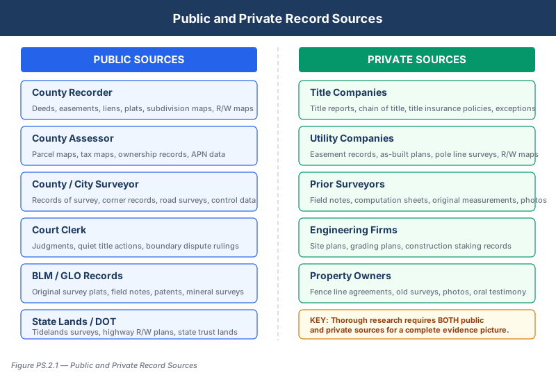
Public Record Sources
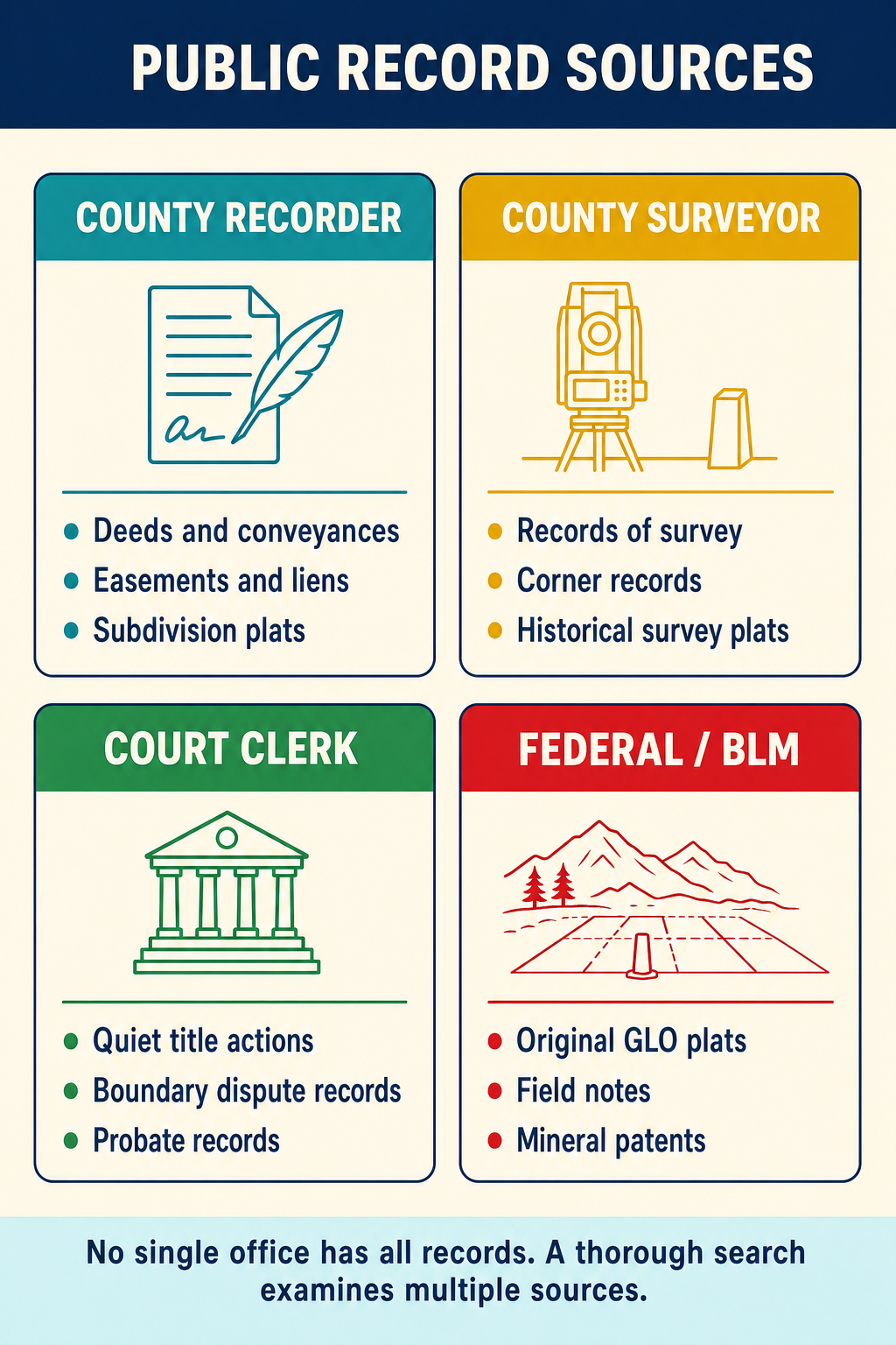
County Recorder's Office
The county recorder maintains the official record of all instruments affecting real property within the county. These are the primary documents a surveyor seeks:
| Document Type | Purpose in Survey |
|---|---|
| Deeds (grant, quitclaim, trust) | Establish chain of title and conveyance history |
| Subdivision maps | Show lot lines, dimensions, monuments, and dedications |
| Records of survey | Document prior survey work and monument evidence |
| Corner records | Describe monument conditions and references |
| Easement documents | Define encumbrances and rights affecting property |
| Liens and encumbrances | Identify restrictions or claims on property |
| Covenants, conditions, and restrictions (CC&Rs) | Establish development and use restrictions |
Indexing systems vary by county. Most use a grantor-grantee index, organized alphabetically by the names of parties. Some counties maintain a tract index that organizes records geographically by subdivision or section. The tract index is generally more useful for surveyors because it groups related documents by location rather than by party name.
County Assessor's Office
The assessor maintains property tax records, which provide:
- Assessor parcel numbers (APNs) -- the standard reference for identifying parcels
- Parcel maps showing assessed boundaries (note: these are tax maps, not survey documents)
- Ownership records including current and historical owners
- Property characteristics such as area, improvements, and use classification
Assessor maps should never be relied upon for boundary positions. They are administrative documents created for tax purposes, not survey-accurate representations of property lines.
County Surveyor's Office
The county surveyor (where this office exists) maintains:
- Records of survey filed within the county
- Corner records documenting public land survey corners and property corners
- Road survey records for county roads and rights-of-way
- Subdivision map checking notes and correspondence
- Historical survey control data
In many jurisdictions, the county or state surveyor reviews and accepts records of survey and corner records before they are filed with the recorder. The county surveyor's files often contain information not available elsewhere, including informal notes, correspondence, and working documents from prior surveys.
Court Records
Court records become essential when boundary disputes, quiet title actions, or partition suits have affected the property. Relevant court documents include:
- Quiet title judgments that may establish or modify boundaries
- Partition decrees that divide property among co-owners
- Condemnation proceedings where government takes property
- Adverse possession rulings affecting boundary positions
- Probate records transferring property through estates
Government Land Office (GLO) / Bureau of Land Management (BLM)
For properties with origins in the public domain, the surveyor must research:
- Original GLO plats showing the Public Land Survey System layout
- Field notes from original government surveys
- Patent records showing initial transfer from government to private ownership
- Mineral survey plats for mining claims
- Dependent resurvey plats and supplemental plats
These records are available through the BLM General Land Office Records website and establish the foundational survey system for much of the western United States.
State and Federal Agencies
Additional public sources include:
| Agency | Records Available |
|---|---|
| State highway department | Right-of-way plans, highway survey data |
| Army Corps of Engineers | Navigation and flood control surveys, mean high water data |
| USGS / NGS | Geodetic control points, benchmark data, topographic maps |
| FEMA | Flood insurance rate maps (FIRMs) |
| State lands commission | Tidelands, navigable waterway boundaries |
| Forest service | National forest boundaries and survey data |
Private Record Sources
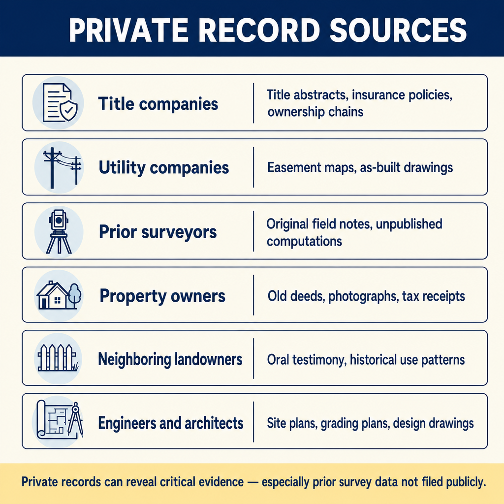
Title Companies
Title companies compile title reports and preliminary title reports that summarize the chain of title and identify encumbrances. For the surveyor, title reports provide:
- A summary of recorded documents affecting the property
- Identification of easements, liens, and restrictions
- The legal description currently of record
- Names of parties in the chain of title for further research
- Exception items that may affect the survey
The surveyor should always request copies of the underlying documents referenced in the title report, not just the summary. Title companies may miss documents or summarize them inaccurately.
Common wrong path — treating the title report as the complete record. A title report summarizes the documents the title company's researcher found relevant to issuing insurance. It is not a complete record of all documents affecting the property, and it is not a substitute for independent records research. Title reports routinely miss: unrecorded easements (especially old utility easements), corner records, prior surveys that weren't tied to title exceptions, and documents indexed under predecessor parties' names. Students on the exam sometimes answer "review the title report" as the complete records-research step; that's insufficient. The correct research includes the title report plus independent searches at the county recorder, county surveyor, GLO/BLM records, utility company records, and prior surveyors' files. A surveyor who relies only on the title report will miss information that a competent colleague would find — and that gap is a liability exposure when the missed document surfaces later.
Quick retrieval check — try before reading on.
▶You receive a title report listing 12 exceptions affecting the subject property. You review all 12 documents. Is your records research complete? What additional sources should you check, and why?
No — the title report is a starting point, not a complete search. Additional sources to check:
- County recorder (independently) — search the grantor-grantee index (or tract index) for documents the title researcher may have missed, including documents indexed under the wrong name, mis-indexed deeds, or documents that affect adjoining properties and therefore affect your subject property.
- County surveyor's office — for corner records, records of survey, and checking notes that may not appear in the title report because they don't constitute "encumbrances" on the property in the insurance-law sense.
- GLO/BLM — original survey plats and field notes for any property with PLSS origins.
- Utility companies — directly contact major utility providers (electric, gas, water, sewer, telecom) for facility maps and easement locations that may be unrecorded or recorded elsewhere.
- Adjoining owners' title chains — check the chains of adjacent properties to identify senior/junior rights and shared boundary history.
- Prior surveyors — contact any surveyor who has worked on this property or in the area; their field notes and opinions may not be in any public record.
- Court records — for any litigation affecting the property or its predecessors.
The title report is the starting point; the thorough search is the complete picture. Failing to go beyond the title report is a common cause of liability claims when undiscovered encumbrances surface post-delivery.
Utility Companies
Utility providers maintain records of their facilities that may constitute easements or affect property use:
- Electric and gas utilities -- pole lines, underground conduits, pipeline easements
- Telephone and cable companies -- overhead and underground facilities
- Water and sewer districts -- mains, laterals, and easement locations
- Irrigation districts -- canal rights-of-way and water rights documentation
Some utility easements are unrecorded, existing only in the utility company's internal files. The surveyor should contact relevant utility providers directly.
Private Survey Files
Prior surveyors who worked in the area may retain field notes, computations, and working documents not reflected in recorded instruments. Professional ethics require sharing survey data that may assist in boundary determination, though the form and extent of this sharing varies by jurisdiction and circumstance.
Conducting a Thorough Records Search
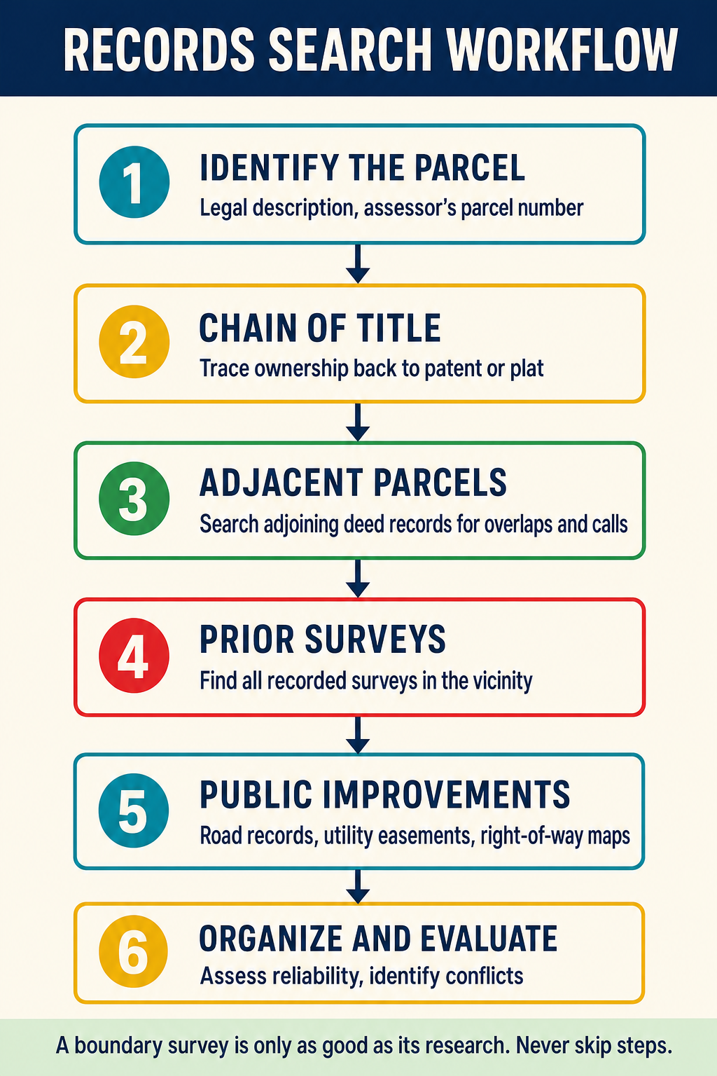
A professional records search follows a systematic process:
- Define the search area -- include the subject property and all adjoining properties, and potentially properties in the surrounding area that share common origins
- Obtain the title report and copies of all referenced documents
- Research the county recorder for deeds, maps, records of survey, and corner records affecting the property and its neighbors
- Check the county surveyor's files for corner records, survey checking notes, and filed records of survey
- Research GLO/BLM records if the property traces to the public domain
- Contact utility companies for easement and facility information
- Check court records if disputes or litigation are indicated
- Contact prior surveyors to obtain field notes and working documents
- Review the chain of title back to a common source (government patent or original grant)
- Compile and analyze all findings, noting discrepancies or gaps
Evaluating Record Quality
Not all records carry equal weight. The surveyor must evaluate each document for:
- Date and context -- older records closer to the original survey may carry more weight
- Author qualifications -- was the document prepared by a licensed professional?
- Internal consistency -- do the measurements and descriptions close mathematically?
- Consistency with other records -- does this document agree with or contradict other evidence?
- Legal status -- is this a recorded instrument, an unrecorded document, or an informal record?
- Completeness -- does the document contain sufficient information for its purpose?
Exam Tips
- The exam frequently tests whether you know which office holds specific types of records (county recorder vs. county surveyor vs. assessor)
- Assessor parcel maps are administrative documents and should never be used as survey-grade boundary evidence
- A thorough records search extends beyond the subject property to include adjoining and nearby parcels
- GLO/BLM records are essential for any property with origins in the Public Land Survey System
- Title reports are a starting point, not a substitute for independent records research
- Unrecorded easements (such as utility easements) may still affect property rights
Related Test Topics
- Chain of title research and analysis
- Public Land Survey System records
- Boundary evidence hierarchy
- Professional liability and standard of care
- Monument evidence documentation
- Legal descriptions interpretation
Further Reading
Authoritative sources for deeper study
Evidence and Procedures for Boundary Location (Robillard, Wilson, & Brown, 7th Ed.) — Practical treatise on collecting, weighing, and applying boundary evidence.
Brown's Boundary Control and Legal Principles (7th Ed., Robillard & Wilson) — Standard textbook on boundary law, evidence hierarchy, and retracement.
Wattles, Writing Legal Descriptions (1976) — Gold-standard reference on metes-and-bounds, sectional, and combination descriptions.
Last updated: 2026-04-17