PS Exam Preparation
Comprehensive preparation for the NCEES Principles and Practice of Surveying (PS) exam. 5 modules covering all 5 exam domains with 50 in-depth topics.
Module 1: Legal Principles
Module 2: Professional Survey Practices
Module 3: Standards & Specifications
Module 4: Business Practices
Module 5: Areas of Practice
Horizontal & Vertical Datums for FEMA
Learning Objectives
After completing this topic, you should be able to:
- Explain the difference between NAVD88 and NGVD29
- Determine which datum is referenced on a FIRM and apply it correctly
- Perform datum conversions between NGVD29 and NAVD88 using VERTCON
- Describe the vertical control requirements for Elevation Certificates
- Identify common datum-related errors in FEMA compliance work
- Explain why datum consistency is critical for flood insurance determination
Overview
Vertical datums are the foundation of every elevation measurement on a FEMA Elevation Certificate. A surveyor who reports building elevations in one datum while the Base Flood Elevation is referenced to another has produced a useless -- and potentially dangerous -- document. An error of even one or two feet in the reported relationship between a building and the BFE can mean the difference between affordable flood insurance and prohibitively expensive premiums, or between a property that appears compliant and one that is actually below the flood level.
The PS exam tests your understanding of the two primary vertical datums used in FEMA work (NAVD88 and NGVD29), how to identify which datum applies, and how to convert between them when necessary.
Key Concepts
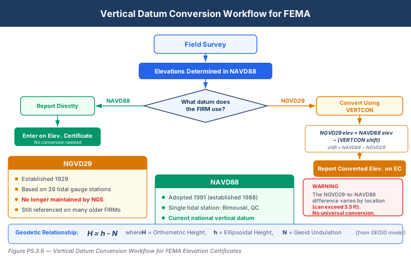
The Two Vertical Datums
National Geodetic Vertical Datum of 1929 (NGVD29):
- Established in 1929 as the national vertical control datum
- Originally called the "Sea Level Datum of 1929" (renamed in 1973)
- Based on a network of 26 tidal gauges along the Atlantic and Pacific coasts and the Gulf of Mexico
- Defined mean sea level (MSL) at those 26 stations as zero elevation
- All other elevations derived from leveling surveys tied to those tidal stations
- No longer maintained or supported by the National Geodetic Survey (NGS) for new work
North American Vertical Datum of 1988 (NAVD88):
- The current national vertical datum, adopted in 1991
- Based on a single tidal station at Father Point/Rimouski, Quebec, Canada
- Incorporates over 600,000 km of releveling data across North America
- Accounts for crustal motion, subsidence, and other geodynamic effects that NGVD29 did not
- Supported by NGS and used for all new vertical control work
Why Both Datums Still Matter
Despite NAVD88 replacing NGVD29 over three decades ago, both datums remain relevant in FEMA work because:
- Older FIRMs reference NGVD29. Many communities still have effective FIRMs that show BFEs in NGVD29. Until FEMA converts these maps, the BFE is officially in NGVD29.
- Newer FIRMs reference NAVD88. Communities that have undergone map modernization have FIRMs with BFEs in NAVD88.
- The FIRM datum controls. Regardless of which datum the surveyor uses in the field, the Elevation Certificate must report elevations in the datum shown on the FIRM.
This means the surveyor must:
- Identify the datum on the applicable FIRM
- Survey building elevations in the field (typically using NAVD88 benchmarks)
- Convert to NGVD29 if the FIRM is referenced to NGVD29
- Report all values in the FIRM datum on the Elevation Certificate
Datum Difference Between NGVD29 and NAVD88
The difference between NGVD29 and NAVD88 varies by geographic location. There is no single conversion factor that applies everywhere. Typical differences:
| Region | Approximate Difference (NAVD88 minus NGVD29) |
|---|---|
| East Coast (New England) | -0.1 to -0.3 ft |
| Southeast (Florida, Gulf Coast) | -0.5 to -1.5 ft |
| Midwest | -0.2 to -0.5 ft |
| Mountain West | +0.5 to +3.5 ft |
| Pacific Northwest | +2.5 to +3.5 ft |
| Alaska | Varies widely |
Critical Point: The sign and magnitude of the difference depend entirely on location. In some areas, NAVD88 elevations are higher than NGVD29; in others, they are lower. Using the wrong conversion or assuming a flat offset is a serious professional error.
VERTCON: The Conversion Tool
The National Geodetic Survey provides VERTCON, a software tool and dataset that computes the conversion between NGVD29 and NAVD88 for any location in the conterminous United States.
How VERTCON works:
- Input: Geographic coordinates (latitude, longitude) and the elevation in one datum
- Output: The elevation in the other datum
- VERTCON uses a grid of modeled datum offsets computed from the national leveling network
- The conversion is specific to the geographic location -- it is NOT a constant
Using VERTCON in practice:
- Survey building elevations using NAVD88 benchmarks (standard modern practice)
- Determine the FIRM datum for the property
- If the FIRM uses NGVD29, obtain the VERTCON conversion factor for the property location
- Apply the conversion: NGVD29 elevation = NAVD88 elevation - VERTCON shift (where the shift is NAVD88 minus NGVD29)
- Report the converted elevation on the Elevation Certificate with a note indicating the conversion was performed
Example:
A surveyor in coastal Florida measures a building's lowest floor at elevation 8.42 ft NAVD88. The FIRM for this location shows BFEs in NGVD29. VERTCON gives a shift of -1.15 ft (NAVD88 minus NGVD29) at this location.
NGVD29 elevation = 8.42 - (-1.15) = 8.42 + 1.15 = 9.57 ft NGVD29
The surveyor reports 9.57 ft NGVD29 on the Elevation Certificate.
Vertical Control Requirements
To produce accurate elevations for an Elevation Certificate, the surveyor must establish reliable vertical control in the field.
Benchmark Sources:
| Source | Description | Typical Accuracy |
|---|---|---|
| NGS Published Benchmarks | National network of vertical control monuments maintained by NGS | First-order: +/- 0.005 m per km; Second-order: +/- 0.008 m per km |
| Local Control | City or county benchmarks tied to the national network | Varies; verify calibration and datum |
| GPS-Derived Elevations | Elevations computed from GNSS observations using a geoid model | Depends on geoid model accuracy and observation quality |
| Assumed Datum | An arbitrary elevation reference | NOT acceptable for Elevation Certificates |
Important Rules:
- An Elevation Certificate must be based on an established vertical datum (NAVD88 or NGVD29), not an assumed datum
- The surveyor must identify the benchmark(s) used, including designation, PID, and published elevation
- If using GPS-derived elevations, the geoid model used must be documented (e.g., GEOID18)
- Level loops should be closed to verify accuracy; the allowable misclosure depends on the survey order
GPS-Derived Elevations for FEMA Work
Modern surveyors frequently use GNSS (GPS) to determine elevations. However, GNSS directly measures ellipsoidal height, not orthometric (datum-based) height. Converting between the two requires a geoid model.
The relationship:
Orthometric Height (H) = Ellipsoidal Height (h) - Geoid Height (N)
Where:
- H = the elevation referenced to NAVD88 (what goes on the Elevation Certificate)
- h = the height above the GRS80 ellipsoid (what GPS measures)
- N = the geoid undulation at that location (from a geoid model like GEOID18)
Quality Considerations for GPS-Derived Elevations:
- Use the current NGS geoid model (GEOID18 as of this writing)
- Static or RTK observations should meet appropriate accuracy standards
- Verify GPS-derived elevations against a published benchmark when possible
- Document the geoid model and observation methodology on the survey
- Some communities or states may not accept GPS-derived elevations for Elevation Certificates -- verify local requirements
Common wrong path — applying a fixed NAVD88-NGVD29 offset across all jurisdictions. Students sometimes learn a "typical" offset (say, −0.8 ft) from one study problem and apply it to any FEMA conversion question. This produces wrong answers more often than right ones because the NAVD88−NGVD29 offset is not a constant — it varies geographically from about −1.5 ft (Gulf Coast, coastal FL) to +3.5 ft (Pacific NW, Mountain West). Applying a coastal-Florida offset to a Colorado project would produce a 4-ft elevation error. The correct procedure always requires VERTCON (or an equivalent location-specific model); no single offset works across states. Exam questions test this by giving a scenario in one region and asking you to identify the conversion; if you answer with a generic offset, you'll likely pick the wrong answer. Always use the location-specific VERTCON value or a stated local shift.
Quick retrieval check — try before reading on.
▶A building in Phoenix, Arizona has a measured lowest floor elevation of 1,245.30 ft NAVD88. The FIRM for the property shows BFEs in NGVD29. VERTCON indicates a local offset of +2.6 ft (NAVD88 minus NGVD29). What is the NGVD29 elevation to report on the Elevation Certificate?
NGVD29 = NAVD88 − (NAVD88 − NGVD29 shift) = 1,245.30 − 2.6 = 1,242.70 ft NGVD29.
Interpretation: NAVD88 elevations are higher than NGVD29 elevations in this region (the shift of +2.6 ft is NAVD88 − NGVD29, meaning NAVD88 reads higher). To report in NGVD29, subtract the shift. If you had used a Gulf Coast offset (say −0.8 ft) instead, you would have reported 1,245.30 − (−0.8) = 1,246.10 ft — about 3.4 ft too high. That error would make the building appear well above the BFE when it may actually be at or below, producing incorrect insurance rating and compliance determinations. The correct practice always queries VERTCON for the specific location; never substitute a generic offset.
Common Datum Errors
The PS exam may present scenarios involving these typical mistakes:
Error 1: Datum Mismatch Reporting building elevations in NAVD88 when the FIRM BFE is in NGVD29, or vice versa. This produces an incorrect relationship between the building and the BFE.
Error 2: Using a Constant Offset Applying a single conversion factor from one project to all projects, regardless of location. The NGVD29-to-NAVD88 difference varies geographically.
Error 3: Ignoring the Geoid Using GPS ellipsoidal heights directly on the Elevation Certificate without applying a geoid model. Ellipsoidal heights are NOT orthometric heights.
Error 4: Using Destroyed or Unstable Benchmarks Tying vertical control to a benchmark that has been disturbed, destroyed, or affected by subsidence without verifying its current elevation.
Error 5: Assumed Datum Using an arbitrary or assumed datum for an Elevation Certificate. FEMA requires all elevations to reference NAVD88 or NGVD29.
Future Datum Considerations
The National Geodetic Survey is developing the North American-Pacific Geopotential Datum of 2022 (NAPGD2022), which will replace NAVD88. Key points for the PS exam:
- NAPGD2022 will be a geoid-based datum, meaning GPS-derived elevations will be directly referenced to the new datum through an updated geoid model
- FEMA will eventually transition FIRMs to the new datum, but this process will take years
- During the transition, surveyors will need to manage conversions between NAVD88 and NAPGD2022 in addition to the ongoing NGVD29 legacy
- As of this writing, NAVD88 remains the official datum for all FEMA work
Exam Tips
- Always check the FIRM to determine the datum -- NGVD29 on older maps, NAVD88 on newer maps; the Elevation Certificate must match the FIRM datum
- VERTCON is location-specific -- there is no universal conversion factor between NGVD29 and NAVD88; the difference varies by geographic location
- The difference between NAVD88 and NGVD29 can be positive or negative depending on location -- never assume a direction
- GPS measures ellipsoidal height, not orthometric height -- a geoid model is required to convert; know the formula H = h - N
- Assumed datums are NEVER acceptable on Elevation Certificates -- only NAVD88 or NGVD29
- If an exam question describes a scenario where the BFE is in NGVD29 and the surveyor measured in NAVD88, the answer involves VERTCON conversion
- The current geoid model is GEOID18 -- this may appear in questions about GPS-derived elevations
- Benchmark verification is essential: always close level loops or verify against independent control
- Some exam questions test whether you know that NGVD29 was originally called "Sea Level Datum of 1929"
- In coastal Florida and the Gulf Coast, the NAVD88-NGVD29 difference can exceed 1.5 feet -- large enough to dramatically affect flood insurance premiums
Related Test Topics
- FEMA Specifications and Flood Zones (Topic 3.4)
- FEMA Elevation Certificates (Topic 3.5)
- GNSS observations and coordinate systems (Module 5)
- Leveling procedures and vertical control (Module 5)
- ALTA/NSPS Standards and precision requirements (Topic 3.2)
Further Reading
Authoritative sources for deeper study
FEMA Elevation Certificate (Form FF-206) — Official form and instructions for NFIP elevation certifications.
NOAA Manual NOS NGS 5 — State Plane Coordinate System of 1983 — Definitive NGS reference for SPCS83 zone constants, projections, and conversions.
NGS Geodetic Glossary (1986, NOAA repository) — Authoritative definitions for geodetic, GNSS, and surveying terms.
Last updated: 2026-04-17