PS Exam Preparation
Comprehensive preparation for the NCEES Principles and Practice of Surveying (PS) exam. 5 modules covering all 5 exam domains with 50 in-depth topics.
Module 1: Legal Principles
Module 2: Professional Survey Practices
Module 3: Standards & Specifications
Module 4: Business Practices
Module 5: Areas of Practice
Consultation Services
Learning Objectives
After completing this topic, you should be able to:
- Describe the surveyor's role as a consultant in land development and real estate transactions
- Explain site analysis and development feasibility assessments
- Identify how topography, access, and environmental constraints affect development
- Describe floodplain analysis, FEMA regulations, and the surveyor's responsibilities
- Explain zoning analysis and variance procedures from the surveyor's perspective
- Understand the surveyor's role as an expert witness in legal proceedings
- Identify the types of consulting engagements common in surveying practice
Overview
Beyond traditional measurement and mapping services, professional land surveyors provide consultation services that leverage their spatial expertise, legal knowledge, and understanding of land development processes. Consultation may include site analysis for development feasibility, floodplain and environmental assessment, zoning compliance review, boundary dispute resolution, and expert testimony in legal proceedings.
The PS exam tests your understanding of the surveyor's consulting role because it represents the highest level of professional practice -- applying integrated knowledge to solve complex, multi-disciplinary problems.
Key Concepts
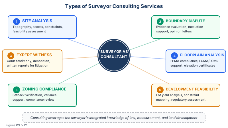
The Surveyor as Consultant
The surveyor's unique combination of skills positions them as a valuable consultant:
- Spatial expertise -- Understanding of terrain, distances, areas, and three-dimensional relationships
- Legal knowledge -- Familiarity with property law, zoning, easements, and regulatory frameworks
- Record research ability -- Skill in finding and interpreting deeds, plats, and public records
- Technical measurement -- Ability to precisely determine positions, elevations, and alignments
- Regulatory familiarity -- Knowledge of local, state, and federal land use regulations
Consultation services differ from traditional survey services in that the client is typically seeking professional judgment and analysis rather than a measured survey product.
Site Analysis and Development Feasibility
Site analysis evaluates whether a parcel of land is suitable for a proposed development:
Topographic factors:
- Terrain slope and its impact on grading costs
- Drainage patterns and stormwater management requirements
- Soil conditions affecting foundation design and utility installation
- Existing vegetation and tree preservation requirements
- Natural features that constrain development (rock outcrops, steep slopes, water features)
Access and circulation:
- Existing road access and adequacy for the proposed use
- Required sight distance at access points
- Traffic generation and capacity of surrounding roads
- Internal circulation requirements (fire access, parking, loading)
- Pedestrian and bicycle access requirements
Utility availability:
- Proximity to public water and sewer
- Capacity of existing utility systems to serve the development
- Cost of extending utilities to the site
- On-site wastewater treatment suitability (soil percolation tests)
- Electric, gas, and communications service availability
Regulatory constraints:
- Zoning classification and permitted uses
- Dimensional requirements (setbacks, height, coverage, FAR)
- Environmental regulations (wetlands, endangered species, stormwater)
- Historical preservation requirements
- Planned infrastructure improvements that may affect the site
Yield analysis:
- Maximum number of lots or units the site can support given all constraints
- Buildable area after deducting for setbacks, easements, floodplains, and slopes
- Comparison of development potential under different zoning scenarios
- Preliminary cost-benefit analysis for development feasibility
Floodplain Analysis
Floodplain consulting is a significant area of surveying practice:
FEMA Flood Insurance Program:
- The National Flood Insurance Program (NFIP) maps flood hazards throughout the United States
- Flood Insurance Rate Maps (FIRMs) delineate Special Flood Hazard Areas (SFHAs)
- Properties in SFHAs with federally backed mortgages must carry flood insurance
- Development in SFHAs is regulated by local floodplain ordinances
Flood zone designations:
| Zone | Description |
|---|---|
| Zone A | 1% annual chance flood (100-year), no BFE determined |
| Zone AE | 1% annual chance flood, BFE determined |
| Zone AH | 1% annual chance shallow flooding (1-3 ft), BFE determined |
| Zone AO | 1% annual chance sheet flow flooding, depths determined |
| Zone V, VE | Coastal high hazard areas with wave action |
| Zone X (shaded) | 0.2% annual chance flood (500-year) |
| Zone X (unshaded) | Areas outside the 500-year floodplain |
Surveyor's role in floodplain work:
- Determine whether a property is within a Special Flood Hazard Area
- Prepare Elevation Certificates documenting building elevations relative to BFE
- Support Letter of Map Amendment (LOMA) applications to remove properties from the SFHA
- Support Letter of Map Revision (LOMR) applications to modify the flood map
- Provide topographic data for flood studies and hydraulic modeling
- Prepare as-built surveys documenting flood-proofing measures
LOMA process:
- A property owner may apply for a LOMA if the natural ground elevation is at or above the BFE
- Requires a surveyor's certification of the property elevation
- If successful, FEMA removes the property from the SFHA
- Does not require a physical map revision -- it is a letter determination
Zoning Analysis and Variance Support
Zoning compliance analysis:
- Determine the zoning classification of the property
- Identify all applicable dimensional and use requirements
- Measure setbacks, lot coverage, building height, and other regulated dimensions
- Compare existing or proposed conditions to zoning requirements
- Document any nonconformities
Variance and special exception support:
- Prepare exhibits showing the property conditions that justify a variance
- Provide testimony at zoning board hearings
- Prepare site plans showing existing conditions and proposed development
- Document the "hardship" or "practical difficulty" that supports the variance request
- Note: the surveyor provides factual testimony and spatial analysis, not legal argument
Boundary Dispute Consultation
Surveyors frequently consult on boundary disputes:
Pre-litigation consulting:
- Research records and perform field investigation
- Prepare a boundary analysis report explaining the surveyor's opinion
- Identify areas of agreement and disagreement between parties
- Recommend resolution approaches (negotiation, boundary line agreement, quiet title action)
Mediation support:
- Present factual findings to a mediator
- Prepare demonstrative exhibits showing the disputed area
- Explain technical aspects in non-technical terms
- Help parties understand the basis for different boundary positions
Expert Witness Testimony
The surveyor may be called to testify as an expert witness in legal proceedings:
Qualifying as an expert:
- Education, licensing, and professional credentials
- Years of experience in the relevant area of practice
- Publications, teaching, and professional involvement
- Previous expert witness experience
Types of testimony:
- Boundary dispute cases (most common for surveyors)
- Easement disputes
- Land use and zoning matters
- Construction defect cases
- Environmental contamination cases (spatial extent)
- Accident reconstruction (measurements and mapping)
Expert witness standards:
- Opinions must be based on sufficient facts and data
- Opinions must be the product of reliable principles and methods
- The expert must have reliably applied the principles to the facts of the case
- The Daubert standard (federal courts) or Frye standard (some state courts) governs admissibility
Common wrong path — offering opinions outside the surveyor's expert qualification. An expert witness can testify on matters within their area of qualification; they are not authorized to opine on everything about the case. A surveyor qualified as an expert on boundary location is not automatically qualified to testify on topics like soil mechanics, hydrology, appraisal, or legal title. Students sometimes answer "the expert can testify on all issues" on exam questions about the scope of expert testimony — that's wrong. A court may exclude testimony that exceeds the expert's demonstrated qualifications. For surveyors: stick to survey-related opinions (boundary location, monument interpretation, record research, compliance with standards), and defer to other experts on questions outside your competence. This narrow-scope discipline protects both the surveyor and the client — straying into unqualified opinions can lead to impeachment on cross-examination and loss of credibility on the topics where the surveyor is qualified.
Quick retrieval check — try before reading on.
▶You are retained as an expert witness in a boundary dispute. During trial, opposing counsel asks you: "In your opinion, has my client's use of the disputed strip ripened into adverse possession under state law?" How should you respond?
Decline to answer the question as a legal conclusion; offer to describe the factual findings within your expert scope.
"I'm qualified as an expert on land surveying — boundary determination, monument interpretation, record research, and application of surveying standards. Whether an occupation has legally 'ripened into adverse possession' requires a legal determination: evaluation of the statutory elements of adverse possession under this state's law (hostility, continuity, open and notorious use, exclusivity, payment of taxes if required, etc.) and application to the specific facts of the case. That is a legal opinion that is outside my expert qualification. I can testify to the physical facts I observed during my survey — the location of the fence, evidence of occupation and cultivation, the duration indicated by aerial photography — but whether those facts satisfy the legal elements of adverse possession is for the court to decide based on testimony from a property-law expert or counsel's legal argument."
A surveyor who answers "yes, the use constitutes adverse possession" is practicing law and likely to be impeached on cross-examination. The disciplined answer keeps the surveyor within their expert scope and preserves credibility on the boundary-location opinions where their expertise actually applies.
Preparing for testimony:
- Review all relevant records, surveys, and documents
- Prepare clear, professional exhibits (maps, diagrams, photographs)
- Anticipate cross-examination questions
- Be prepared to explain methodology and reasoning
- Distinguish between fact testimony and opinion testimony
- Maintain objectivity -- the expert serves the court, not the hiring party
Key rules for expert testimony:
- Answer only the question asked
- Acknowledge limitations of your analysis
- Never overstate the certainty of your opinions
- Explain technical concepts in plain language
- Do not advocate for one party -- present objective professional analysis
Types of Consulting Engagements
| Engagement Type | Description |
|---|---|
| Due diligence review | Review existing surveys and documents for a real estate transaction |
| Feasibility study | Evaluate a site for proposed development |
| Boundary analysis | Research and analyze boundary evidence without performing a full survey |
| Peer review | Review another surveyor's work product for accuracy and compliance |
| Regulatory support | Prepare applications and exhibits for zoning, floodplain, or environmental permits |
| Expert testimony | Testify in court or at hearings on surveying-related matters |
| Right-of-way consultation | Analyze and value right-of-way needs for public projects |
| Title review | Review title documents for survey-related issues |
Exam Tips
- The surveyor as consultant provides professional judgment and analysis, not just measurements -- this is a higher level of service
- LOMA applications remove properties from the Special Flood Hazard Area based on natural ground elevation at or above the BFE
- Zone AE indicates a 1% annual chance (100-year) flood area with Base Flood Elevations determined
- Expert witnesses must maintain objectivity and serve the court, not the hiring party
- The Daubert standard evaluates whether expert testimony is based on reliable methodology, not just the expert's qualifications
- Site feasibility analysis considers topography, access, utilities, regulations, and environmental constraints as an integrated assessment
- The surveyor provides factual testimony and spatial analysis in zoning hearings but does not make legal arguments
- Floodplain Elevation Certificates require the surveyor to document building elevations relative to the Base Flood Elevation
Related Test Topics
- ALTA surveys and zoning (Topic 5.1, Table A Items 3, 6)
- Condominiums, zoning, and deed restrictions (Topic 5.10)
- Boundary surveys and evidence evaluation (Topic 5.5)
- Topographic mapping for site analysis (Topic 5.7)
- As-built surveys for elevation certificates (Topic 5.11)
- Professional ethics and standards of care (Module 3)
- Business practices and engagement management (Module 4)
Further Reading
Authoritative sources for deeper study
NCEES Model Rules of Professional Conduct (Aug 2025) — Model ethics, competence, and licensure rules adopted by most state boards.
Brown's Boundary Control and Legal Principles (7th Ed., Robillard & Wilson) — Standard textbook on boundary law, evidence hierarchy, and retracement.
Last updated: 2026-04-17