PS Exam Preparation
Comprehensive preparation for the NCEES Principles and Practice of Surveying (PS) exam. 5 modules covering all 5 exam domains with 50 in-depth topics.
Module 1: Legal Principles
Module 2: Professional Survey Practices
Module 3: Standards & Specifications
Module 4: Business Practices
Module 5: Areas of Practice
Boundary Surveys & Reconciliations
Learning Objectives
After completing this topic, you should be able to:
- Describe the process of searching for and evaluating physical evidence of boundaries
- Explain how to reconcile conflicting evidence from different sources
- Understand historical measurement accuracy and its impact on retracement surveys
- Apply legal principles governing boundary location and retracement
- Describe the hierarchy of evidence in boundary determination
- Explain the concept of following in the footsteps of the original surveyor
- Identify common sources of boundary disputes and their resolution
Overview
Boundary surveying is the core practice area that distinguishes a professional land surveyor from other measurement professionals. The boundary surveyor's task is not merely to measure distances and angles but to determine the location of property boundaries based on the available evidence -- physical, documentary, and testimonial. This requires the integration of legal knowledge, field investigation skills, historical awareness, and professional judgment.
The PS exam tests boundary surveying heavily because it synthesizes legal principles (Module 1), professional practices (Module 2), and fieldwork into the definitive act of the surveying profession: locating the boundary on the ground.
Key Concepts
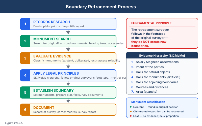
Physical Evidence of Boundaries
The first and most important step in a boundary survey is the search for physical evidence. Physical evidence includes:
Original monuments:
- Stone markers, iron pipes, iron rods, concrete monuments
- Bearing trees, witness trees, mound and pit markers
- Natural monuments (rivers, ridges, shorelines, rock outcrops)
- Called-for monuments (objects specifically described in the deed or plat)
Accessory evidence:
- Fence lines (may indicate long-standing boundary occupation)
- Walls and hedgerows
- Occupation lines (mowed areas, maintained boundaries)
- Witness corners and reference monuments
- Survey markers set by previous surveyors
Improvements and use patterns:
- Building locations relative to described boundaries
- Driveways, sidewalks, and paved areas
- Agricultural use patterns (crop rows, field edges)
- Utility alignments that follow property boundaries
Evidence Evaluation and Hierarchy
The surveyor must evaluate evidence within a legal framework. The general hierarchy of controlling elements (from most to least authoritative) is:
- Natural monuments -- Rivers, lakes, ridges, trees called for as corners
- Artificial monuments -- Iron pipes, stones, stakes set by the original surveyor
- Adjoiners and record boundaries -- Boundaries of adjacent properties
- Courses (bearings/directions) -- Direction calls in the deed
- Distances -- Distance calls in the deed
- Area -- Acreage calls (least controlling)
This hierarchy is not absolute. The weight given to each type of evidence depends on the specific facts of the survey. A well-established artificial monument may control over a poorly defined natural feature.
Reconciliation of Conflicting Evidence
Boundaries rarely close perfectly. The surveyor must reconcile:
Record vs. measured:
- Deed calls may not match current measurements due to original surveyor's methods, instrument accuracy, or changes in the physical landscape
- The surveyor must determine whether discrepancies are within the range of the original measurement accuracy or indicate a genuine problem
Monument vs. measurement:
- When a monument is found that does not agree with the called-for distance or bearing, the monument generally controls (absent evidence that it is not the original monument)
- The surveyor must evaluate whether the monument is original, undisturbed, and properly identified
Adjoining surveys vs. subject survey:
- Boundaries common to adjacent properties must be consistent
- Senior rights (earlier conveyances) generally prevail over junior rights
- Overlaps and gaps between descriptions must be resolved using the rules of construction
Multiple deed calls:
- When a deed contains conflicting calls, the hierarchy of controlling elements guides resolution
- Specific calls control over general calls
- Definite calls control over indefinite calls
Historical Measurement Accuracy
Understanding the accuracy of historical surveys is critical to proper retracement:
| Era | Instruments | Typical Accuracy |
|---|---|---|
| Colonial (1600s-1700s) | Chain, compass | Bearings: 1-2 degrees; Distances: 1:50 to 1:100 |
| Early American (1800s) | Improved compass, Gunter's chain | Bearings: 30 minutes; Distances: 1:100 to 1:300 |
| Transit era (1850s-1950s) | Transit, steel tape | Bearings: 1-5 minutes; Distances: 1:3,000 to 1:10,000 |
| Modern (1950s-present) | Theodolite, EDM, total station | Bearings: 1-10 seconds; Distances: 1:10,000 to 1:100,000+ |
| GPS/GNSS (1990s-present) | GNSS receivers | Sub-centimeter to centimeter |
Why this matters:
- A deed from 1850 calling for a bearing of N 45 E may have been measured with a compass accurate to only one degree
- The retracing surveyor must not reject a found monument simply because it does not fall on the exact bearing called in the deed, if the discrepancy is within the accuracy range of the original instrument
- Holding a modern measurement to exactly match a historical call may produce an incorrect boundary
Retracement Principles
A retracement survey follows these fundamental principles:
Follow the footsteps of the original surveyor:
- The retracing surveyor's job is to locate the boundary where the original surveyor placed it, not to establish a new boundary
- If the original monuments can be found, they control regardless of whether the modern measurement matches the record call
Do not create new boundaries:
- A retracement surveyor has no authority to establish new boundaries
- Only the property owner (through agreement or conveyance) or a court can change a boundary
- The surveyor renders a professional opinion about where the boundary is located
Give effect to the intent of the parties:
- The boundary should be located where the original parties intended it to be
- Intent is gathered from the deed language, the physical evidence, and the surrounding circumstances
Evaluate all available evidence:
- No single piece of evidence should be accepted or rejected without considering all other evidence
- The surveyor must weigh each piece of evidence according to its reliability and relevance
Common Boundary Disputes
Encroachments:
- A structure or improvement that crosses the boundary onto neighboring property
- Surveyors identify encroachments; courts resolve them
- The surveyor should document the encroachment's location, extent, and apparent age
Gaps and overlaps:
- Occur when adjacent deed descriptions do not align
- Gaps: A strip of land not described in any deed
- Overlaps: The same strip described in two or more deeds
- Resolution depends on senior/junior rights, original intent, and unwritten rights
Ambulatory boundaries:
- Water boundaries that move with accretion, erosion, or reliction
- The boundary moves with gradual natural changes but not with sudden changes (avulsion)
Common wrong path — treating a retracement as a redesign. The retracing surveyor's only job is to locate the boundary where the original surveyor placed it. That means following original monuments, applying rotation/scale corrections derived from found monuments, and using proportioning only as a last resort for truly lost corners. Students with engineering-or-construction instincts sometimes "improve" the original by applying modern precision to correct bearings or distances — in effect, creating a new boundary that is mathematically more precise but legally wrong. The original survey, regardless of its precision, created the property; the retracement merely locates it. Exam questions bait this trap by showing a found monument 1.5 ft from the calculated position and asking what controls — the answer is always the monument, provided it is called for, identifiable, and undisturbed. Modern measurements do not correct the original surveyor; they describe the present position of the original corner in modern coordinates.
Quick retrieval check — try before reading on.
▶An 1875 deed calls "N 45° 00' E, 800 feet to an iron post." The post is found, clearly original (matching character, weathered, with bearing-tree stump nearby). Your measurement from the POB gives N 45° 42' E, 803.20 ft to the post. What do you report as the bearing and distance of this line on your plat?
Report the measured values (N 45° 42' E, 803.20 ft) — not the record values — because the monument controls. The bearing and distance on the plat reflect what you actually measured; the record call is shown separately in a "record vs measured" table or in parentheses. The 42' bearing variation and 3.2 ft distance variation are within expected 1875 compass-and-chain accuracy, so the monument is almost certainly original and controls. You should NOT report N 45° 00' E / 800.00 ft — that would misrepresent your measurements. And you should NOT split the difference or adjust — the monument defines the line.
Unwritten rights:
- Adverse possession, prescriptive easements, boundary by acquiescence, and practical location can modify written boundaries
- The surveyor should be aware of potential unwritten rights but typically cannot make the legal determination
Boundary Survey Deliverables
A boundary survey typically produces:
- Survey plat/map showing boundaries, monuments, bearings, distances, and area
- Legal description (if new or revised)
- Boundary analysis narrative explaining the surveyor's reasoning and evidence evaluation
- Monument records documenting what was found, set, and referenced
- Title report review noting any exceptions that were or could not be plotted
Exam Tips
- The hierarchy of controlling elements (natural monuments, artificial monuments, adjoiners, courses, distances, area) is one of the most tested concepts on the PS exam
- Remember: the retracing surveyor follows the footsteps of the original surveyor -- you are finding an existing boundary, not creating a new one
- Historical measurement accuracy matters: do not reject a found monument because it does not match a historical call to modern precision
- Natural monuments control over artificial monuments, which control over courses, which control over distances, which control over area
- When deed calls conflict, specific calls control over general calls, and definite calls control over indefinite calls
- The surveyor renders an opinion about the boundary location; only a court can establish a boundary when parties disagree
- Senior rights (first in time) generally prevail over junior rights in overlap situations
- Ambulatory water boundaries move with gradual natural changes but not with sudden avulsive changes
Related Test Topics
- Legal principles of boundary law (Module 1, all topics)
- ALTA/NSPS surveys (Topic 5.1)
- Controlling elements and evidence hierarchy (Module 1, Topic 1.5)
- Easement rights and unwritten rights (Module 1, Topics 1.3, 1.4, 1.6)
- Legal descriptions (Module 1, Topic 1.9)
- PLSS perpetuation (Module 1, Topic 1.10)
Further Reading
Authoritative sources for deeper study
Brown's Boundary Control and Legal Principles (7th Ed., Robillard & Wilson) — Standard textbook on boundary law, evidence hierarchy, and retracement.
Evidence and Procedures for Boundary Location (Robillard, Wilson, & Brown, 7th Ed.) — Practical treatise on collecting, weighing, and applying boundary evidence.
Wattles, Writing Legal Descriptions (1976) — Gold-standard reference on metes-and-bounds, sectional, and combination descriptions.
2021 ALTA/NSPS Land Title Survey Standards — Current minimum standard detail requirements for ALTA/NSPS land title surveys.
Last updated: 2026-04-17