PS Exam Preparation
Comprehensive preparation for the NCEES Principles and Practice of Surveying (PS) exam. 5 modules covering all 5 exam domains with 50 in-depth topics.
Module 1: Legal Principles
Module 2: Professional Survey Practices
Module 3: Standards & Specifications
Module 4: Business Practices
Module 5: Areas of Practice
As-Built/Record Drawing Surveys
Learning Objectives
After completing this topic, you should be able to:
- Explain the purpose and scope of as-built surveys
- Distinguish between as-built surveys and record drawings
- Describe the field techniques used for as-built data collection
- Identify what elements must be measured and documented in an as-built survey
- Explain how as-built data is compared to design plans
- Describe tolerance and acceptance criteria for constructed improvements
- Understand the legal and contractual significance of as-built documentation
Overview
As-built surveys and record drawings document the actual position, elevation, and dimensions of constructed improvements after completion. While construction surveys (Topic 5.4) establish design positions before and during construction, as-built surveys verify what was actually built and how it compares to the design. This documentation serves as the permanent record of the constructed project and is essential for facility management, future design, regulatory compliance, and legal protection.
Key Concepts
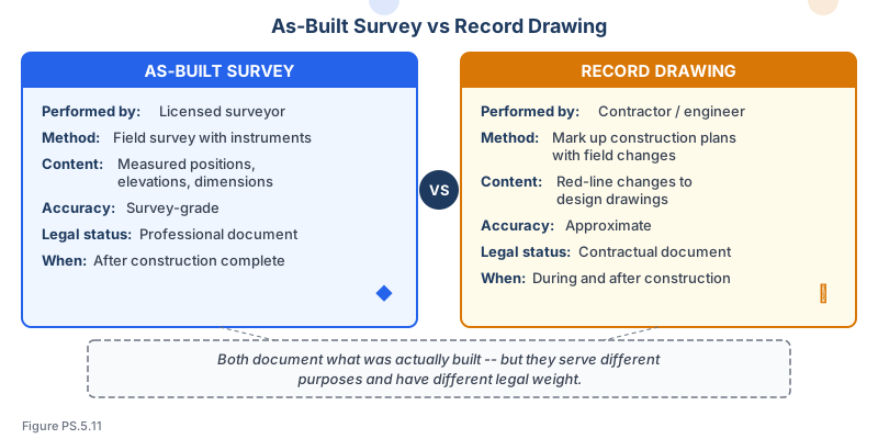
As-Built Surveys vs. Record Drawings
These terms are related but distinct:
As-built survey:
- A field survey performed after construction to measure and document the actual positions, elevations, and dimensions of constructed features
- Performed by a surveyor using survey instruments
- Produces measured data that can be compared to design plans
- May be required at multiple stages of construction (foundation, underground utilities, finish grade)
Record drawings (as-built drawings):
- Construction plans that have been updated to reflect actual constructed conditions
- Typically prepared by the contractor or engineer by marking up the original design plans with field-measured deviations
- May incorporate data from the surveyor's as-built survey
- Become the permanent construction record for the owner and facility manager
Key distinction: An as-built survey is a measured survey product from a licensed surveyor. Record drawings are modified design plans that may incorporate survey data along with contractor field notes and inspector records.
Purpose of As-Built Documentation
Regulatory compliance:
- Municipalities require as-built surveys to verify that construction matches approved plans
- Floodplain administrators require elevation certificates to verify compliance with flood regulations
- Utility departments require as-built surveys of underground utilities before backfilling
Contractual obligations:
- Verify that the contractor built the project to specifications
- Document deviations from the design for change order purposes
- Establish the basis for final payment and project acceptance
Facility management:
- Record the actual locations of buried utilities for future maintenance and repair
- Document building positions relative to property lines for future development
- Provide baseline data for future renovations and additions
Legal protection:
- Protect the surveyor by documenting what was actually staked versus what was built
- Protect the owner by documenting compliance with zoning, setbacks, and other requirements
- Protect the contractor by documenting that work was performed to specification
Elements Typically Documented
Site improvements:
- Building corners and foundation positions relative to property lines
- Finished floor elevations
- Finished grade elevations at key points
- Parking areas, driveways, sidewalks, and curb locations
- Retaining wall positions and top/bottom elevations
- Stormwater management facilities (detention ponds, inlets, outlet structures)
Underground utilities:
- Pipe invert elevations at manholes, inlets, and connections
- Pipe sizes, materials, and slopes
- Horizontal positions of pipes, conduits, and cables
- Manhole rim elevations
- Valve locations and depths
- Service connection points
Building elements (when required):
- Foundation dimensions and positions
- Steel column locations
- Floor slab elevations
- Structural element positions for multi-story construction
- Elevator shaft positions
- Building height
Roadway and site grading:
- Centerline alignment and profile
- Edge of pavement positions and elevations
- Curb and gutter positions
- Ditch and swale inverts
- Top and toe of embankment slopes
Field Techniques
Horizontal positioning:
- Total station measurements from project control
- GNSS (RTK) positioning for exterior features
- Tape measurements for close-range details
- Offsets from known reference lines
Vertical measurements:
- Differential leveling for precise elevations (utility inverts, floor elevations)
- Trigonometric leveling from total station for general features
- GNSS-derived elevations for site features where appropriate
- Rod readings into manholes and inlets for invert elevations
Timing considerations:
- Underground utilities must be surveyed before backfilling (critical window)
- Foundation surveys occur before framing (to verify position before vertical construction proceeds)
- Final as-built occurs after all site improvements are complete
- Some features can only be measured at specific construction stages
Common wrong path — as-built = as-staked. Two related but distinct deliverables: as-staked records document what the surveyor staked in the field (design position, cut/fill information, layout coordinates). As-built records document what the contractor actually built. The two are not the same thing, and both are important for different reasons. An as-staked record protects the surveyor — it shows that the correct design position was marked in the field. An as-built record documents deviations from the design for the owner, engineer, and future facility manager. Students on the exam sometimes conflate them, answering "the surveyor's as-built survey" when the question is really about the as-staked layout from construction stakeout (which is preconstruction documentation, not post-construction). The key distinction: as-staked happens before construction (shows design); as-built happens after (shows reality). If the question describes the surveyor's obligation to document what they staked, that's as-staked. If the question describes documenting what the contractor built, that's as-built. They're both valuable, but they're different documents with different purposes.
Quick retrieval check — try before reading on.
▶Your crew staked a new sewer line along a design alignment with invert elevation 120.50 ft at STA 10+00. Three weeks later, the contractor completed construction and requested a final survey before acceptance. You measure the sewer invert at 120.43 ft. Which deliverable documents this difference, and what should you do with the data?
The as-built survey documents this — the actual constructed invert is 120.43 ft, 0.07 ft below design. Compare to the as-built tolerance for gravity sewer invert (typically ±0.01–0.02 ft). The deviation of 0.07 ft exceeds typical tolerance, so flag it as a potential issue on the deviation report.
Report the data to the owner and engineer with the comparison against design, but do NOT decide whether the deviation is acceptable — that's the engineer's or owner's call, based on whether the 0.07 ft drop affects the gravity flow design or introduces a backflow risk. Separately, document that the as-staked layout was at design position (120.50 ft at STA 10+00) as shown in your original stakeout records — that separates "was it staked correctly" (yes, per as-staked) from "was it built correctly" (no, per as-built), allowing responsibility to be assigned clearly. The construction record should preserve both documents for the permanent project file.
Plan Comparison and Deviation Reporting
The core deliverable of an as-built survey is the comparison between design and actual construction:
Comparison methods:
- Overlay as-built positions on the design plans
- Compute horizontal and vertical deviations at each measured point
- Prepare a deviation report listing all points that exceed tolerances
- Color-code or symbol-code the drawing to highlight areas of concern
Typical deviation reporting format:
| Feature | Design Position | As-Built Position | Deviation | Tolerance | Status |
|---|---|---|---|---|---|
| Bldg NE Corner | N 1000.00, E 2000.00 | N 1000.05, E 1999.97 | 0.06 ft | 0.10 ft | Pass |
| MH-1 Rim | 425.50 | 425.43 | -0.07 ft | 0.05 ft | Fail |
| Sewer Inv MH-1 | 420.25 | 420.28 | +0.03 ft | 0.02 ft | Fail |
Acceptance Criteria and Tolerances
Tolerances for as-built surveys depend on the project specifications and the type of improvement:
| Improvement | Typical Horizontal Tolerance | Typical Vertical Tolerance |
|---|---|---|
| Building position | 0.10 ft | 0.02 ft (floor elev) |
| Road centerline | 0.05 ft | 0.02 ft |
| Gravity sewer invert | 0.10 ft | 0.01-0.02 ft |
| Storm drain invert | 0.10 ft | 0.02-0.05 ft |
| Water main | 0.10 ft | 0.10 ft |
| Finish grade | 0.20 ft | 0.05-0.10 ft |
| Curb and gutter | 0.05 ft | 0.02 ft |
When tolerances are exceeded:
- The surveyor documents the deviation
- The engineer or owner decides whether the deviation is acceptable
- Remedial action (reconstruction, redesign, or acceptance with conditions) is determined by the project team
- The surveyor does not make the acceptance decision -- the surveyor provides the data
Elevation Certificates
A specialized form of as-built survey for flood zone compliance:
- Required for buildings in FEMA-designated Special Flood Hazard Areas
- Documents the lowest floor elevation, machinery/equipment elevations, and flood openings
- Compared to the Base Flood Elevation (BFE) shown on the Flood Insurance Rate Map (FIRM)
- Must be prepared by a licensed surveyor or engineer
- Used for flood insurance rating and regulatory compliance
- Required both pre-construction (foundation) and post-construction (finished)
Documentation Standards
As-built survey deliverables typically include:
- As-built survey drawing showing all measured positions and elevations
- Deviation report comparing as-built to design
- Surveyor's certification of accuracy
- Control information and datum references
- Date of survey and equipment used
- Digital data files (CAD, GIS) when specified
Record drawing standards:
- Must clearly indicate which information is as-built versus as-designed
- All revisions must be dated and initialed
- Underground utility depths and materials must be clearly labeled
- Final record drawings are typically delivered in both hard copy and digital format
Exam Tips
- Underground utilities must be surveyed before backfilling -- this is the most time-critical as-built survey element
- As-built surveys are measured data from a licensed surveyor; record drawings are modified design plans that may incorporate survey data
- Gravity sewer inverts require the tightest vertical tolerances because flow depends on precise grade
- The surveyor documents deviations but does not decide whether they are acceptable -- that decision belongs to the engineer or owner
- Elevation certificates are a specific type of as-built survey required for flood zone compliance
- Know the difference between an as-built survey performed during construction versus a final as-built at project completion
- As-built data becomes the permanent record for facility management -- errors in as-built documentation can cause problems decades later when utilities are located for future work
- As-staked records (from construction staking, Topic 5.4) protect the surveyor by showing what was staked; as-built surveys show what was actually constructed
Related Test Topics
- Construction surveys and staking (Topic 5.4)
- Topographic mapping for existing conditions (Topic 5.7)
- Control networks for project control (Topic 5.2)
- Consultation services -- floodplain analysis (Topic 5.12)
- ALTA surveys for existing improvements (Topic 5.1)
- Professional documentation and records (Module 2, Topic 2.10)
Further Reading
Authoritative sources for deeper study
Kavanagh, Surveying with Construction Applications (7th Ed.) — Combined surveying and construction-layout reference.
Wolf & Ghilani, Elementary Surveying — An Introduction to Geomatics (13th+ Ed.) — Comprehensive surveying text covering instruments, field procedures, and computations.
FGDC Geospatial Positioning Accuracy Standards — National standard for positional accuracy reporting (NSSDA).
Last updated: 2026-04-17