PS Exam Preparation
Comprehensive preparation for the NCEES Principles and Practice of Surveying (PS) exam. 5 modules covering all 5 exam domains with 50 in-depth topics.
Module 1: Legal Principles
Module 2: Professional Survey Practices
Module 3: Standards & Specifications
Module 4: Business Practices
Module 5: Areas of Practice
ALTA/NSPS Land Title Surveys
Learning Objectives
After completing this topic, you should be able to:
- Explain the purpose and legal significance of an ALTA/NSPS Land Title Survey
- Identify the minimum standard detail requirements for ALTA/NSPS surveys
- Describe the Relative Positional Precision (RPP) requirement and how it is computed
- List and explain the optional Table A items and when they apply
- Describe the surveyor's responsibilities regarding title commitments and legal documents
- Explain how zoning compliance and underground utilities relate to ALTA surveys
- Understand the certification requirements and their implications
Overview
The ALTA/NSPS Land Title Survey is the highest standard of boundary survey in commercial real estate practice in the United States. Jointly developed by the American Land Title Association (ALTA) and the National Society of Professional Surveyors (NSPS), these standards provide a uniform national framework for surveys that support commercial real estate transactions, title insurance, and lending decisions.
The current standards were adopted in 2021 and replace all previous versions. Every PS exam candidate must know the ALTA standards in detail because they integrate boundary law, measurement standards, title examination, zoning analysis, and professional certification into a single deliverable.
Key Concepts
Purpose of ALTA/NSPS Surveys
ALTA surveys serve several critical functions in commercial real estate:
- Title insurance underwriting -- Provide the spatial information title companies need to insure against survey-related defects
- Lender due diligence -- Banks and lenders rely on ALTA surveys to confirm that improvements are within boundaries and that no encroachments exist
- Transaction support -- Buyers, sellers, and attorneys use the survey to understand the physical and legal condition of the property
- Encumbrance identification -- Locate and show easements, encroachments, rights of way, and other matters affecting the property
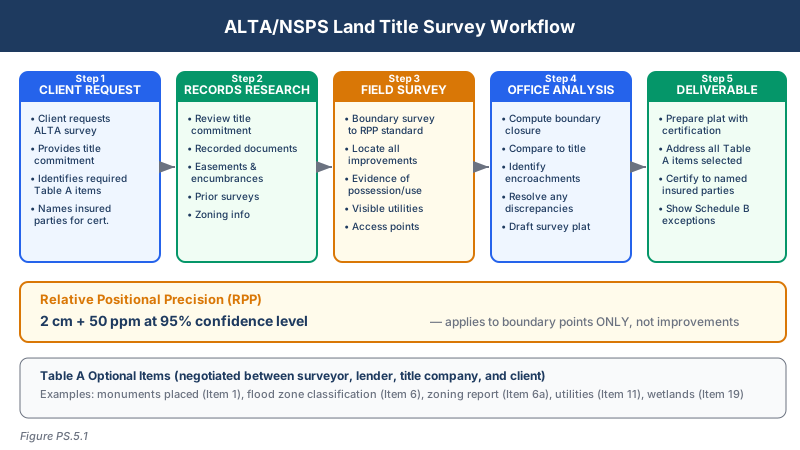
Minimum Standard Detail Requirements
The 2021 ALTA/NSPS standards establish the following minimum requirements:
Boundary determination:
- Research deeds, relevant recorded documents, and applicable court records
- Locate boundary lines and corners based on the legal description in the title commitment
- Show all monuments found, set, or to be set
- Present measured and record distances along all boundary lines
Improvements and features:
- All buildings, structures, and improvements on the surveyed property
- Visible evidence of use by other than the owner (encroachments)
- Driveways, alleys, and private roads
- All walls, fences, and hedges on or within five feet of the boundary
- Evidence of water features affecting the property
Easements and encumbrances:
- Plot all easements, servitudes, and rights of way referenced in the title commitment
- Identify visible evidence of easements not referenced in the title commitment
- Show utilities serving the property
Survey plat requirements:
- North arrow, graphic scale, and legend
- Basis of bearings
- Street names and route numbers
- Certificate of survey with signature, seal, date, and professional license number
Relative Positional Precision (RPP)
The RPP concept was introduced in the 2011 standards under the name "Relative Positional Precision," replacing the older "Relative Positional Accuracy" from the 2005 standards, and was retained in the 2016 and 2021 updates. RPP applies only to boundary points, not improvements or other features.
The RPP Standard:
| Component | Value |
|---|---|
| Standard | 2 cm + 50 ppm |
| Confidence level | 95% |
| Applies to | Boundary points only |
How RPP is calculated:
RPP = 0.02 m + 50 ppm of the distance between any two boundary points
For a property with a 500-meter frontage:
- RPP = 0.02 + (500 x 0.000050) = 0.02 + 0.025 = 0.045 m (4.5 cm)
For a property with a 100-meter frontage:
- RPP = 0.02 + (100 x 0.000050) = 0.02 + 0.005 = 0.025 m (2.5 cm)
Key exam points about RPP:
- RPP describes the uncertainty in the position of any boundary point relative to any other boundary point on the survey
- It does NOT apply to improvements, topographic features, or other non-boundary elements
- The surveyor must state the RPP achieved on the survey plat
- RPP is a positional tolerance, not an angular or distance tolerance
Table A Optional Items
Table A contains optional survey responsibilities that a client may select in addition to the minimum requirements. The surveyor must negotiate these items before beginning fieldwork.
| Item | Description |
|---|---|
| 1 | Monuments placed or to be placed at all major boundary corners |
| 2 | Address(es) of the surveyed property |
| 3 | Flood zone designation with FIRM community/panel number and date |
| 4 | Gross land area (and other areas if requested) |
| 5 | Vertical relief with source of benchmark and datum |
| 6 | (a) Current zoning classification with setback requirements; (b) Zoning compliance determination |
| 7 | (a) Exterior dimensions of all buildings at ground level; (b) Square footage of all buildings; (c) Building heights above grade |
| 8 | Substantial visible features within 5 feet of each side of boundary (walls, fences, buildings) |
| 9 | Location of utilities on or serving the surveyed property from field observations and utility records |
| 10 | Governmental agency survey-related requirements as specified by the client |
| 11 | Location of wetland areas as delineated by qualified specialist |
| 12-20 | Additional optional items for specific situations |
Title Commitments and Legal Documents
The surveyor must review the title commitment (or title report) to identify:
- Legal description -- The boundary the survey must depict
- Schedule B-II exceptions -- Easements, restrictions, and other matters that must be plotted
- Record documents -- Deeds, plats, and other instruments referenced in the commitment
The surveyor is not expected to render a legal opinion on the title but must plot the spatial extent of each exception that can be located from the record documents or field evidence.
Zoning and Setback Requirements
When Table A Item 6 is selected:
Item 6(a) requires the surveyor to report:
- Current zoning classification
- Applicable setback requirements (front, side, rear)
- Height and floor area ratio (FAR) requirements, if available
Item 6(b) requires the surveyor to determine:
- Whether the current use complies with the zoning classification
- Whether existing improvements comply with dimensional requirements
- The surveyor reports findings but does not render a legal opinion
Underground Utilities
Table A Item 9 requires utility location from:
- Field observations -- Visible evidence of utilities (manholes, valve boxes, meters, transformers, pedestals, overhead lines)
- Utility records -- Information obtained from utility companies and public records
- Underground utility locating -- When requested, utility locates per ASCE 38 standards (Quality Levels A through D)
The surveyor must clearly distinguish between observed utilities, record utilities, and located utilities on the plat.
Certification
The ALTA/NSPS certification is a formal statement by the surveyor that the survey was performed in accordance with the minimum standard detail requirements. The certification:
- Must be signed and sealed by the surveyor
- Must identify the applicable Table A items that were included
- Names the parties who may rely on the survey (insured, lender, title company)
- Constitutes a professional representation that creates legal liability
- Must reference the 2021 standards specifically
The certification language is prescribed by the standards and should not be materially modified without consultation with the client and title company.
Common wrong path — rendering legal opinion on title matters. The ALTA survey requires the surveyor to plot the spatial extent of every Schedule B-II exception that can be located from record documents. It does not require — or permit — the surveyor to opine on whether an easement is valid, whether a restriction is enforceable, or whether a deed of trust has been satisfied. Exam questions sometimes frame this as "the surveyor notices that one of the recorded easements appears to have been abandoned — should they exclude it from the plat?" The answer is no. Plot what the title commitment instructs you to plot. Legal effect is for the title company and the parties' attorneys. The surveyor's scope is spatial, not juridical. This is the single biggest liability trap for new ALTA-survey practitioners, and the exam tests it directly.
Quick retrieval check — try before reading on.
▶Your title commitment lists "Exception B-17: 30-ft drainage easement recorded in Book 452, Page 123." On site, you find no physical drainage feature — no ditch, no pipe, no swale — and the adjoining property owner tells you the easement "was never built and is expired." How do you treat this on the ALTA plat?
Plot the easement from the recorded dimensions and location. You do not render an opinion on whether it is valid, abandoned, or expired — those are legal questions. Show the easement as a dashed or hatched area with the book/page reference and a note identifying it as Exception B-17 from the title commitment. You may add a surveyor's note: "Easement plotted per record; no physical evidence of drainage improvements observed at the time of survey." That factual statement is within your scope; any conclusion about validity is not. The title company and the parties' attorneys decide what to do with the exception. Your job is to depict it accurately so they have the spatial information needed to decide.
Exam Tips
- The RPP formula (2 cm + 50 ppm at 95% confidence) is one of the most frequently tested values on the PS exam -- memorize it and know how to apply it
- Remember that RPP applies to boundary points only, not to improvements or other features
- Table A items are optional -- the surveyor is not required to perform them unless specifically requested
- The surveyor reviews title documents to identify what must be plotted, but does not render a legal opinion on title
- The 2021 ALTA/NSPS standards supersede all previous versions -- if an exam question references an older standard, the 2021 requirements control
- Understand the difference between Table A Item 6(a) (reporting zoning) and 6(b) (determining compliance)
- Know that ASCE 38 governs subsurface utility engineering quality levels when underground locating is requested
Related Test Topics
- Boundary surveys and legal descriptions (Topic 5.5)
- Datums and reference frames for vertical requirements (Topic 5.3)
- Map accuracy standards (Topic 5.13)
- Professional standards of care (Module 3)
- Easements, encroachments, and property rights (Module 1)
- Zoning and deed restrictions (Topic 5.10)
Further Reading
Authoritative sources for deeper study
2021 ALTA/NSPS Land Title Survey Standards — Current minimum standard detail requirements for ALTA/NSPS land title surveys.
Brown's Boundary Control and Legal Principles (7th Ed., Robillard & Wilson) — Standard textbook on boundary law, evidence hierarchy, and retracement.
Wattles, Writing Legal Descriptions (1976) — Gold-standard reference on metes-and-bounds, sectional, and combination descriptions.
Last updated: 2026-04-17