PS Exam Preparation
Comprehensive preparation for the NCEES Principles and Practice of Surveying (PS) exam. 5 modules covering all 5 exam domains with 50 in-depth topics.
Module 1: Legal Principles
Module 2: Professional Survey Practices
Module 3: Standards & Specifications
Module 4: Business Practices
Module 5: Areas of Practice
Surveys for New Parcels & Subdivisions
Learning Objectives
After completing this topic, you should be able to:
- Describe the different types of subdivisions and their regulatory frameworks
- Explain the platting process from concept through final recording
- Identify lot design standards including minimum area, frontage, and access requirements
- Describe the surveyor's role in the subdivision approval process
- Explain regulatory compliance requirements at local, state, and federal levels
- Understand the relationship between subdivision plats and legal descriptions
- Describe monumentation requirements for subdivisions
Overview
Subdivision surveys divide existing parcels of land into smaller lots or tracts for sale, development, or other purposes. Subdivision is one of the most regulated areas of surveying practice, involving local ordinances, state statutes, and sometimes federal requirements. The surveyor plays a central role in the subdivision process -- from initial feasibility analysis through final plat preparation and monumentation.
The PS exam tests your understanding of subdivision types, platting requirements, lot design standards, and the regulatory framework governing the creation of new parcels.
Key Concepts
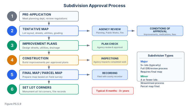
Types of Subdivisions
Major subdivision:
- Creation of a specified number of lots (varies by jurisdiction, often 5 or more)
- Requires full regulatory review (planning commission, governing body)
- Typically requires construction of public improvements (roads, utilities, drainage)
- Subject to environmental review requirements
- Requires preliminary and final plat approval
Minor subdivision (lot split):
- Creation of a small number of lots (typically fewer than 5)
- Simplified review process
- May not require public improvements
- Often requires only a final plat or survey
- Subject to zoning and dimensional requirements
Planned Unit Development (PUD):
- Flexible zoning that allows mixed land uses and varied lot configurations
- May include common areas, open space, and shared facilities
- Reviewed as a unified development plan
- Often permits higher density in exchange for open space preservation
- Development plan becomes a binding legal document
Metes and bounds subdivision:
- Division of land described by metes and bounds rather than a recorded plat
- Permitted in some jurisdictions for minor splits
- Does not create a subdivision plat of record
- May create title problems and is generally discouraged
The Platting Process
Phase 1: Feasibility and concept
- Preliminary site investigation (topography, utilities, access, environmental constraints)
- Zoning review (permitted uses, density, dimensional requirements)
- Concept plan showing general lot layout, road alignment, and open space
- Coordination with planning staff for initial feedback
Phase 2: Preliminary plat
- Detailed lot layout with dimensions, areas, and street design
- Utility layout (water, sewer, storm drainage, electric)
- Grading and drainage plan
- Environmental features (wetlands, floodplains, steep slopes)
- Traffic analysis and access design
- Submission to planning commission for review and public hearing
- Conditional approval with required modifications
Phase 3: Construction
- Build required public improvements (roads, utilities, drainage structures)
- Construct stormwater management facilities
- Install erosion and sediment controls
- Staking and inspection of improvements during construction
Phase 4: Final plat
- Boundary survey of the entire subdivision and each lot
- Monumentation of all lot corners, street intersections, and curve points
- Preparation of the final plat for recording
- Certification by the surveyor
- Approval signatures from planning commission, governing body, and other authorities
- Recording in the county land records
Plat Requirements
A subdivision plat must typically include:
Boundary information:
- Perimeter boundary of the subdivision with bearings, distances, and curve data
- Tie to section corners, PLSS, or other reference system
- Basis of bearings statement
- Relationship to adjacent subdivisions and parcels
Lot information:
- Lot numbers and block numbers
- Lot dimensions (bearings, distances, curve data for all lot lines)
- Lot areas (in square feet or acres)
- Building setback lines
- Easement locations and dimensions
Street information:
- Street names and right-of-way widths
- Centerline geometry (tangents, curves, with full curve data)
- Cul-de-sac dimensions
- Intersection details
Other required elements:
- North arrow, graphic scale, and legend
- Title block with subdivision name, location, owner, and surveyor information
- Dedication of streets, easements, and other public areas
- Certification by the surveyor (accuracy, compliance with standards)
- Approval blocks for planning commission, governing body, and utilities
- Monumentation schedule (type and location of monuments set)
- Flood zone designation
- Reference to any covenants, conditions, and restrictions (CC&Rs)
Lot Design Standards
Lots must comply with zoning and subdivision ordinance requirements:
Dimensional requirements:
| Standard | Typical Requirement |
|---|---|
| Minimum lot area | Varies by zoning (e.g., 5,000 SF to 5+ acres) |
| Minimum lot width | Measured at front building line (e.g., 50-200 feet) |
| Minimum lot frontage | Required road frontage (e.g., 25-150 feet) |
| Minimum lot depth | Rear building line to front building line |
| Maximum lot depth-to-width ratio | Typically 3:1 or 4:1 |
| Flag lots | Minimum access strip width (e.g., 20-50 feet) |
Design considerations:
- Lots should be rectangular or regular in shape when possible
- Side lot lines should be approximately perpendicular to the street
- On curves, lot lines should be radial to the curve
- Corner lots often require additional width to accommodate side-street setbacks
- Double-frontage lots (fronting two parallel streets) are generally avoided
- Lots should be designed to drain properly without adverse impact on neighbors
Access and Street Design
Street hierarchy:
- Arterial -- Major routes carrying through traffic
- Collector -- Connect local streets to arterials
- Local -- Provide direct access to lots; low traffic volume
- Cul-de-sac -- Dead-end streets with turnaround; limited to maximum length
Key design parameters:
- Right-of-way width (typically 50-80 feet for local streets)
- Pavement width
- Horizontal and vertical alignment (minimum sight distance, maximum grade)
- Intersection spacing and geometry
- Cul-de-sac radius (typically 50-60 feet to property line)
Easements
Subdivisions typically include multiple types of easements:
- Utility easements -- For water, sewer, gas, electric, and communications (typically 10-20 feet wide along lot lines)
- Drainage easements -- For stormwater conveyance (width varies with drainage requirements)
- Access easements -- For shared driveways or access to landlocked parcels
- Conservation easements -- Protecting environmental features
- Pedestrian easements -- For walkways and trails
Monumentation Requirements
Subdivision ordinances typically require monuments at:
- All exterior boundary corners of the subdivision
- All lot corners
- Street centerline curve points (PC, PT, PI)
- Street intersections
- Points of change in direction on lot lines
- Beginning and end of easement lines along boundaries
Monument types:
- Iron pipes or rods (typically 1/2 to 1 inch diameter)
- Concrete monuments at primary corners
- Survey caps or tags stamped with surveyor's license number
- Brass or aluminum disks in concrete or asphalt for centerline control
Common wrong path — side lot lines parallel to the street on a curve. On a straight street, side lot lines typically run perpendicular to the street centerline — essentially parallel to each other and to the neighbors'. Students sometimes extend this rule to curved street frontage: "side lot lines should be parallel to each other on a curve." That's wrong. On a curve, side lot lines should be radial — each side line points back toward the center of the curve. If drawn parallel instead, the lots would either overlap (inside of curve) or leave triangular gaps (outside of curve), neither of which is platable. Exam questions test this with a scenario showing a cul-de-sac or a curved collector street and asking which lot-line orientation is correct. Answer: radial to the curve, not parallel to adjacent lot lines and not perpendicular to the chord.
Quick retrieval check — try before reading on.
▶A subdivision has four lots along a curving street (R = 300 ft, I = 60°, arc = 314.16 ft). Each lot has 78.54 ft of frontage along the arc. If the side lot lines are drawn radial to the curve, what is the angle (at the lot corner on the street) between the street frontage arc and the side lot line?
90° — because a radial line by definition is perpendicular to the tangent of the curve at any point. The side lot line, being radial, strikes the curve at a right angle to the tangent at that point. This is why radial lot lines on curves are the default: they produce a "tangent-perpendicular" corner geometry consistent with perpendicular-side-line geometry on straight streets. Note that the chord of the 78.54-ft arc is about 78.32 ft (barely shorter than the arc for this 15°-per-lot central angle), and the chord is not the tangent — radial lot lines are perpendicular to the tangent, not to the chord, so they do NOT bisect the chord unless the curve is infinitely gentle.
Regulatory Compliance
Local requirements:
- Zoning ordinance (uses, density, dimensional standards)
- Subdivision ordinance (design standards, improvement requirements, plat format)
- Engineering standards (road design, utility design, drainage)
- Health department (on-site septic suitability, if applicable)
State requirements:
- State subdivision statutes (varies by state)
- Professional licensing and survey standards
- Environmental regulations (wetlands, stormwater, erosion control)
- State highway department approval (if accessing state roads)
Federal requirements:
- Clean Water Act (Section 404 wetlands permitting)
- National Flood Insurance Program (floodplain development requirements)
- Endangered Species Act (if applicable)
- Archaeological and historical preservation requirements
Exam Tips
- Know the difference between major and minor subdivisions and their approval processes
- Lot design: side lot lines should be perpendicular to the street; on curves, they should be radial
- Final plats must include complete curve data (radius, arc length, chord bearing, chord distance, central angle) for all curves
- Monuments are required at all lot corners, boundary corners, and curve points -- memorize this list
- Cul-de-sac lots have narrow frontage and wide rear lines (pie-shaped); corner lots need extra width for side setbacks
- The surveyor certifies the plat but does not approve it -- approval comes from the planning commission and governing body
- Understanding the difference between a preliminary plat (for review) and a final plat (for recording) is important
- Flag lots require a minimum access strip width specified by the local ordinance
- Easements shown on the plat become appurtenant to the subdivision and cannot be easily removed after recording
Related Test Topics
- Condominiums, zoning, and deed restrictions (Topic 5.10)
- Boundary surveys for parent tract and lot lines (Topic 5.5)
- Route surveys for street design (Topic 5.6)
- Construction surveys for subdivision improvements (Topic 5.4)
- Legal descriptions for subdivided parcels (Module 1, Topic 1.9)
- Professional standards for plat preparation (Module 3)
Further Reading
Authoritative sources for deeper study
2021 ALTA/NSPS Land Title Survey Standards — Current minimum standard detail requirements for ALTA/NSPS land title surveys.
Wattles, Writing Legal Descriptions (1976) — Gold-standard reference on metes-and-bounds, sectional, and combination descriptions.
Brown's Boundary Control and Legal Principles (7th Ed., Robillard & Wilson) — Standard textbook on boundary law, evidence hierarchy, and retracement.
Kavanagh, Surveying with Construction Applications (7th Ed.) — Combined surveying and construction-layout reference.
Last updated: 2026-04-17