PS Exam Preparation
Comprehensive preparation for the NCEES Principles and Practice of Surveying (PS) exam. 5 modules covering all 5 exam domains with 50 in-depth topics.
Module 1: Legal Principles
Module 2: Professional Survey Practices
Module 3: Standards & Specifications
Module 4: Business Practices
Module 5: Areas of Practice
FEMA Elevation Certificates
Learning Objectives
After completing this topic, you should be able to:
- Explain the purpose and regulatory basis of the Elevation Certificate
- Identify the sections of the Elevation Certificate (A through H) and who completes each
- Describe the building elevation measurements required in Section C
- Select and apply the correct building diagram for the structure type
- Explain the certification requirements in Sections D and E
- Understand when an Elevation Certificate is required and who prepares it
Overview
The FEMA Elevation Certificate (FEMA Form 086-0-33) is the administrative tool used to document a building's elevation relative to the Base Flood Elevation (BFE). It serves three critical purposes in the National Flood Insurance Program:
- Determining proper flood insurance premium rates -- Insurance premiums are based on the relationship between the building's lowest floor elevation and the BFE
- Supporting requests for Letters of Map Amendment (LOMA) -- Property owners seeking removal from the SFHA must provide elevation data
- Documenting compliance with community floodplain management ordinances -- Communities use Elevation Certificates to verify that new construction meets or exceeds BFE requirements
For land surveyors, the Elevation Certificate is one of the most common FEMA-related deliverables. The PS exam tests your understanding of the form's structure, the measurements required, and the surveyor's certification responsibilities.
Key Concepts
When an Elevation Certificate is Required
An Elevation Certificate is typically required in the following situations:
- New construction in an SFHA: Most communities require an Elevation Certificate for any new building or substantial improvement in a flood zone
- Insurance rating: Lenders and insurance agents need elevation data to determine flood insurance premiums
- LOMA applications: The property owner must demonstrate that the building or lot is above the BFE
- Community compliance: Floodplain administrators use Elevation Certificates to verify that construction meets local floodplain ordinances
Who Prepares the Elevation Certificate
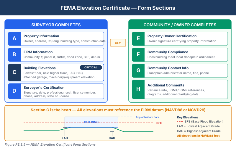
The form has multiple sections completed by different parties:
- Sections A, B, and C -- Completed by a licensed land surveyor, registered professional engineer, or registered architect (varies by state; many states restrict Section C to licensed surveyors)
- Section D -- Surveyor's certification (signature, seal, license number)
- Section E -- Building owner's certification (if community requires it)
- Sections F, G, and H -- Completed by the community floodplain administrator
For the PS exam, focus on Sections A through D -- these are the surveyor's responsibility.
Section A: Property Information
Section A captures identifying information about the property and building:
- Property owner's name and address
- Building street address (including city, state, ZIP)
- Property description (legal description or tax parcel number)
- Building use (residential or non-residential)
- Latitude and longitude of the building
- Original date of construction or substantial improvement
- Whether the building is in a Coastal Barrier Resources System (CBRS) area
Key Detail: The latitude and longitude must be the actual coordinates of the building, not the property centroid or a mailing address point. The surveyor determines these coordinates during the field survey.
Section B: Flood Insurance Rate Map Information
Section B documents the FIRM data applicable to the property:
- NFIP community name and community number
- Map panel number and suffix
- FIRM effective date or preliminary date
- Flood zone designation
- Base Flood Elevation (if available)
- Whether the building is in the floodway
- Datum used for the BFE on the FIRM
Critical Rule: The BFE datum shown in Section B must match the datum shown on the FIRM. If the FIRM references NGVD29, the BFE is in NGVD29. The surveyor must then ensure that the building elevations in Section C are referenced to the same datum, or convert appropriately (see Topic 3.6).
Section C: Building Elevation Information
Section C is the heart of the Elevation Certificate and contains the measured building elevations. This is where the surveyor's field work is documented.
Required Elevation Measurements:
| Line | Measurement | Description |
|---|---|---|
| C2.a | Top of bottom floor (including basement, crawlspace, or enclosure) | The elevation of the finished floor of the lowest level |
| C2.b | Top of the next higher floor | The elevation of the first floor above the lowest level |
| C2.c | Bottom of the lowest horizontal structural member (V zones only) | Required in coastal zones; determines wave action clearance |
| C2.d | Attached garage (top of slab) | The floor elevation of any attached garage |
| C2.e | Lowest elevation of machinery/equipment | HVAC, electrical, plumbing serving the building |
| C2.f | Lowest adjacent grade (LAG) | The lowest ground elevation immediately adjacent to the building |
| C2.g | Highest adjacent grade (HAG) | The highest ground elevation immediately adjacent to the building |
Adjacent Grade Measurements:
LAG and HAG are measured at the building perimeter, not at the property boundary. These measurements determine the ground-to-floor relationship and are used in insurance rating.
- Lowest Adjacent Grade (LAG): The lowest point of the ground surface immediately next to the building foundation. This is the most critical grade measurement because it represents the point where floodwater would first reach the structure.
- Highest Adjacent Grade (HAG): The highest point of the ground surface immediately next to the building foundation.
Datum Requirement: All elevations in Section C must reference the same datum as the BFE shown on the FIRM. If the FIRM is referenced to NAVD88, all Section C elevations must be in NAVD88. If the FIRM is referenced to NGVD29, the surveyor must either survey in NGVD29 or convert NAVD88 field elevations to NGVD29.
Building Diagrams
The Elevation Certificate includes a set of standardized building diagrams that illustrate different foundation types and construction configurations. The surveyor must select the diagram that best represents the subject building. The diagram number is recorded on the form.
Common Building Diagram Types:
| Diagram | Foundation Type | Key Feature |
|---|---|---|
| 1 | Slab-on-grade (no basement/crawlspace) | Simplest configuration; lowest floor is the slab |
| 2 | Basement (floor below grade on all sides) | Lowest floor is the basement floor |
| 3 | Split-level (floor partially below grade) | Multiple lowest-floor elevations may apply |
| 4 | Elevated on piles/columns (no enclosure) | Common in coastal V zones; measure bottom of lowest structural member |
| 5 | Elevated on piles/columns with enclosure below | Enclosure below BFE used for parking, storage, or access only |
| 6 | Elevated on crawlspace (with flood vents) | Crawlspace below BFE with proper flood openings |
| 7 | Manufactured (mobile) home on foundation | Special considerations for manufactured housing |
| 8 | Elevated on piles/columns with enclosure below (alternative) | Variation of Diagram 5 for specific configurations |
| 9 | Building over water (V zone) | Structure built on piles/columns over open water |
Selecting the Correct Diagram:
The surveyor must physically inspect the building to determine the correct diagram. Key considerations:
- Is there a basement (floor below grade on all sides)?
- Is there a crawlspace? Are flood openings (vents) present?
- Is the building elevated on piles, piers, columns, or posts?
- Is there an enclosure below the elevated building?
- What is the enclosure used for (parking, storage, access, or habitable space)?
The diagram selection affects which elevation measurements are required and how insurance premiums are calculated.
Section D: Surveyor's Certification
Section D is where the surveyor certifies the accuracy of the information provided in Sections A through C. The certification includes:
- Statement that the information is correct and that elevations were obtained using standard surveying practices
- Surveyor's printed name, license number, and state
- Telephone number and email address
- Signature and date
- Professional seal/stamp
Important: The surveyor is certifying the accuracy of the elevation measurements and the property/FIRM information. The surveyor is NOT certifying compliance with floodplain regulations -- that determination is made by the community floodplain administrator in Sections F through H.
Section E: Property Owner Certification
Some communities require the property owner to sign Section E, acknowledging that the information is correct. This section is not completed by the surveyor.
Sections F, G, and H: Community Use
These sections are reserved for the local floodplain administrator:
- Section F: Community information and determination of compliance
- Section G: Community contact information
- Section H: Additional comments
The surveyor does not complete these sections but should be aware that the community will review the Elevation Certificate for compliance purposes.
Common Errors and Quality Control
Frequent errors on Elevation Certificates that the PS exam may test:
- Datum mismatch: Building elevations in NAVD88 when the FIRM references NGVD29, or vice versa, without conversion
- Wrong FIRM panel: Using an outdated or incorrect FIRM panel; the effective date must be current
- Incorrect diagram selection: Choosing the wrong building diagram, which affects which measurements are required
- Missing measurements: Failing to measure all required elevations (especially LAG/HAG and machinery/equipment)
- Coordinate error: Latitude/longitude that does not match the building location
- Zone misidentification: Incorrectly identifying the flood zone, especially when zone boundaries cross the property
Common wrong path — mixing datums between the FIRM and field measurements. The single most common error on real Elevation Certificates is datum mismatch. Field surveys today are almost always in NAVD88; older FIRMs may still reference NGVD29. If the FIRM's BFE is 12.5 ft (NGVD29) and your field work produces an LAG of 13.2 ft (NAVD88), you cannot compare the two directly — the datum difference (which varies spatially, typically 0–1 ft in CONUS) must be applied. The correct procedure: (1) check the FIRM for datum; (2) either survey in that datum using a benchmark referenced to it, or (3) survey in NAVD88 and apply NGS's VERTCON to convert. Reporting NAVD88 elevations on a certificate whose BFE is in NGVD29 — without noting the conversion — produces an apparent "freeboard" of 0.7 ft that doesn't actually exist, and may mis-rate insurance or fail floodplain compliance. The certificate explicitly requires the same datum throughout; enforce it yourself.
Quick retrieval check — try before reading on.
▶A FIRM in effect shows BFE = 24.5 ft referenced to NGVD29. Your GNSS survey measures the LAG at 25.8 ft (NAVD88). At this location, NAVD88 − NGVD29 = +1.1 ft (NAVD88 elevations are numerically higher than NGVD29 by 1.1 ft). Does the LAG sit above the BFE?
Convert the field measurement into the FIRM's datum (NGVD29) before comparing: LAG(NGVD29) = LAG(NAVD88) − 1.1 = 25.8 − 1.1 = 24.7 ft NGVD29. That's 0.2 ft above the 24.5 ft BFE — a narrow margin. If you had compared the raw NAVD88 value (25.8) to the NGVD29 BFE (24.5) without converting, you'd report a 1.3 ft clearance — about six times too high, producing a misleading insurance rating and potentially a compliance failure. On the certificate, record the datum used, report the converted elevation, and note the conversion method in the comments. NGS's VERTCON tool provides grid-based conversions; many state DOTs publish regional conversion factors as well.
Elevation Certificate vs. Flood Zone Determination
These are different deliverables:
| Feature | Elevation Certificate | Flood Zone Determination |
|---|---|---|
| Purpose | Document building elevations relative to BFE | Determine which flood zone a property is in |
| Requires field survey | Yes (elevation measurements) | Not necessarily (can be determined from FIRM) |
| Form | FEMA Form 086-0-33 | No standard form; may be a letter or notation |
| Who prepares | Licensed surveyor, PE, or architect | Surveyor, insurance agent, or title company |
| ALTA/NSPS Table A Item 3 | Not directly triggered | This is what Table A Item 3 requests |
Exam Tips
- The surveyor completes Sections A through D; the community completes Sections F through H; the owner may complete Section E
- All elevations in Section C must be in the same datum as the BFE on the FIRM -- if the FIRM uses NGVD29, you must report in NGVD29
- LAG and HAG are measured at the building perimeter, not the property boundary
- Know the building diagrams by foundation type: slab (1), basement (2), crawlspace with vents (6), elevated on piles (4-5), manufactured home (7)
- The surveyor certifies the accuracy of elevations; the community determines compliance with floodplain ordinances
- Bottom of lowest horizontal structural member (C2.c) is required in V zones only (coastal velocity zones)
- An Elevation Certificate is NOT the same as a flood zone determination -- the EC requires field elevation measurements; a flood zone determination can sometimes be done from the FIRM alone
- If the exam describes a situation where FIRM BFE is in NGVD29 but the surveyor measured in NAVD88, the surveyor must convert before completing the certificate
- The latitude and longitude on the form must be for the building, not the parcel centroid
Related Test Topics
- FEMA Specifications and Flood Zones (Topic 3.4)
- Datums for FEMA Compliance (Topic 3.6)
- ALTA/NSPS Standards and Table A Item 3 (Topic 3.2)
- Vertical control and leveling procedures (Module 5)
- Professional certification and liability (Module 2)
Further Reading
Authoritative sources for deeper study
FEMA Elevation Certificate (Form FF-206) — Official form and instructions for NFIP elevation certifications.
NOAA Manual NOS NGS 5 — State Plane Coordinate System of 1983 — Definitive NGS reference for SPCS83 zone constants, projections, and conversions.
NGS Geodetic Glossary (1986, NOAA repository) — Authoritative definitions for geodetic, GNSS, and surveying terms.
Last updated: 2026-04-17