PS Exam Preparation
Comprehensive preparation for the NCEES Principles and Practice of Surveying (PS) exam. 5 modules covering all 5 exam domains with 50 in-depth topics.
Module 1: Legal Principles
Module 2: Professional Survey Practices
Module 3: Standards & Specifications
Module 4: Business Practices
Module 5: Areas of Practice
Control Networks & Geodetic Surveys
Learning Objectives
After completing this topic, you should be able to:
- Describe the purpose and design of horizontal and vertical control networks
- Explain triangulation, trilateration, and precise traversing methods
- Understand the role of the National Geodetic Survey (NGS) and its control network
- Describe CORS, OPUS, and other NGS positioning services
- Identify the classification and order of geodetic control stations
- Explain network adjustment methods and accuracy reporting
- Distinguish between local, regional, and national control frameworks
Overview
Control networks provide the spatial framework upon which all surveying measurements are referenced. A geodetic control network consists of precisely positioned horizontal and vertical control stations whose coordinates and elevations have been determined to known accuracies. These stations serve as the foundation for boundary surveys, construction projects, topographic mapping, and engineering design.
The National Geodetic Survey (NGS) maintains the National Spatial Reference System (NSRS), which defines the official coordinate system for the United States. Professional surveyors must understand how to access, evaluate, and extend geodetic control networks for their projects.
Key Concepts
Purpose of Control Networks
Control networks serve several essential functions:
- Spatial reference -- Provide a consistent coordinate framework for all survey measurements in a project area
- Accuracy propagation -- Transfer known positions from higher-order control to project-specific points
- Quality assurance -- Enable checking and verification of survey measurements through redundancy
- Legal reference -- Establish the coordinate basis for boundary surveys, plats, and legal descriptions
- Multi-project coordination -- Allow different surveys and projects to be combined on a common framework
Types of Control Surveys
Horizontal control establishes positions (latitude/longitude or northing/easting):
| Method | Description | Typical Use |
|---|---|---|
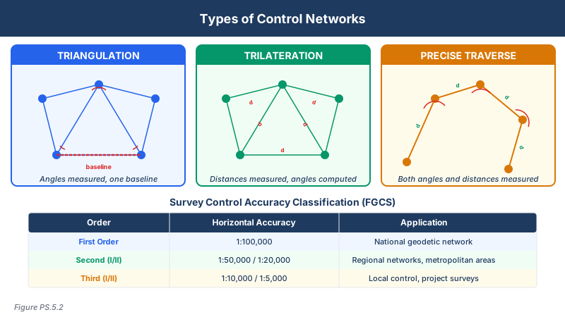
| Triangulation | Measure angles in a network of triangles from known baselines | Classical first-order control |
| Trilateration | Measure distances between stations using EDM | Post-1960s control densification |
| Precise traversing | Sequential angle and distance measurements through a connected series of stations | Urban and corridor control |
| GPS/GNSS | Satellite-based positioning using carrier phase observations | Modern control establishment |
Vertical control establishes elevations (orthometric heights):
| Method | Description | Typical Use |
|---|---|---|
| Differential leveling | Precise measurement of elevation differences using a level and rods | Primary vertical control |
| Trigonometric leveling | Elevation differences from vertical angles and distances | Secondary control, rough terrain |
| GNSS-derived heights | Ellipsoid heights converted using geoid models | Supplement to leveling |
Triangulation
Triangulation was the primary method for establishing horizontal control from the 1800s through the mid-1900s. The method uses:
- A precisely measured baseline (the only distance measured directly)
- Angles measured at each station in a network of interconnected triangles
- Computation of all other distances using the sine rule
- Progressive extension of the network from the baseline outward
Strengths of triangulation:
- Only required precise distance measurement for the baseline
- Angular measurements were less affected by terrain than distance measurements
- Well-suited to establishing regional and national networks
Limitations:
- Required intervisibility between stations, often on hilltops or towers
- Strength of figure depended on triangle geometry (equilateral triangles are strongest)
- Less efficient than modern methods for local control
Trilateration
Trilateration emerged with the development of Electronic Distance Measurement (EDM) instruments in the 1960s:
- All distances in the network are measured directly
- Positions are computed from the intersection of distance arcs
- No angular measurements required (though they may be included for redundancy)
- Well-suited to networks where EDM equipment is available
Precise Traversing
Precise traversing is a sequential method:
- Traverse stations are connected in an open or closed path
- Both angles and distances are measured at each station
- Closure checks (angular and positional) detect errors
- Closed traverses (returning to the starting point or closing on another known station) are required for control work
Traverse types:
- Closed loop -- Returns to the starting point; provides full closure check
- Closed on known points -- Begins and ends on stations with known coordinates
- Open traverse -- No closure; unacceptable for control work
National Geodetic Survey (NGS)
NGS is the federal agency responsible for defining and maintaining the NSRS. Key responsibilities include:
- Establishing and maintaining the national horizontal and vertical datums
- Publishing coordinates and descriptions of geodetic control stations
- Operating the CORS network and OPUS processing service
- Developing geoid models (GEOID18, etc.) for converting ellipsoid heights to orthometric heights
- Publishing standards for geodetic control surveys
NGS Control Station Classification
Control stations are classified by accuracy standards:
| Order | Horizontal Accuracy | Vertical Accuracy | Typical Use |
|---|---|---|---|
| First Order (Class I, II) | 1:100,000 | 0.5 mm/km (Class I), 0.7 mm/km (Class II) | National framework, scientific studies |
| Second Order (Class I, II) | 1:50,000 (I), 1:20,000 (II) | 1.0 mm/km (I), 1.3 mm/km (II) | Metropolitan area control, large engineering projects |
| Third Order (Class I, II) | 1:10,000 (I), 1:5,000 (II) | 2.0 mm/km | Local control, small engineering projects |
Vertical accuracy values above are standard error per kilometer of leveling used for station classification. For allowable loop misclosure tolerances (3.0/4.0/6.0/8.0/12.0 mm√K), see the QA/QC Methods topic.
CORS (Continuously Operating Reference Stations)
The CORS network consists of permanently installed GNSS receivers that:
- Operate 24/7 collecting satellite observations
- Provide data for post-processing of GNSS surveys
- Support real-time positioning through RTN (Real-Time Networks)
- Are managed by NGS in cooperation with partners
- Have precisely determined coordinates in the NSRS
Using CORS data:
- Download observation files from the NGS CORS website
- Process baselines from CORS stations to project points
- Achieve centimeter-level positioning for control surveys
- Establish direct ties to the NSRS without occupying passive control monuments
OPUS (Online Positioning User Service)
OPUS is a free NGS service that processes GNSS data:
- Upload a RINEX observation file from a single receiver
- NGS computes the position relative to three nearby CORS stations
- Returns NAD 83 coordinates and NAVD 88 orthometric height (via geoid model)
- Requires a minimum of 2 hours of static data (OPUS-S) or 15 minutes (OPUS-RS for rapid static)
- Peak-to-peak differences between the three CORS solutions indicate quality
Common wrong path — overconstraining a network without first checking it. When adjusting a control network, the temptation is to fix every published NGS coordinate and let the observations bend to fit. This is wrong. If one of the "known" stations has been disturbed, has outdated coordinates from a superseded datum, or has a large inherent uncertainty, a fully constrained adjustment will smear that error through the entire network and hide real measurement problems. The correct sequence is: (1) run a free adjustment (minimum constraints — usually one station + one azimuth) to evaluate the observations on their own merits; (2) inspect residuals and error ellipses for blunders and systematic issues; (3) then run a constrained adjustment that fixes only control stations whose published uncertainties are consistent with your observations' quality. Exam questions test this by presenting a scenario with large residuals on a constrained station; the correct answer is always "run a free adjustment first and re-evaluate which stations to hold."
Quick retrieval check — try before reading on.
▶You run a free least-squares adjustment on a 12-station GNSS network. The chi-square test passes, the largest standardized residual is 1.8, and all error ellipses are small and similarly sized. You then run a fully constrained adjustment fixing all four NGS control stations, and suddenly three of the free-network stations show standardized residuals above 3.0. What does this likely tell you, and what would you do next?
The observations themselves are clean (free adjustment passed cleanly). The blowup on constraining is almost certainly caused by a problem with one or more of the held NGS control stations — likely disturbed, renamed, referenced to a superseded datum (NAD 83(1986) vs. NAD 83(2011), for example), or with published coordinates that have much larger uncertainty than your observations. Next steps: (1) hold only one NGS station and a single azimuth to reorient the free network into the NSRS; (2) compare the resulting published-vs-adjusted coordinates at the other three held stations; (3) identify which specific station is the outlier; (4) either exclude that station from the held set or verify with NGS records whether its coordinates have been superseded. Do not simply accept the fully constrained adjustment — it is mixing bad control into good observations.
Network Adjustment
Control networks are adjusted using least squares methods:
- Free adjustment -- Holds only the minimum constraints needed to define the coordinate system; used to evaluate internal network quality
- Constrained adjustment -- Holds one or more control stations fixed; used to fit the network into an existing coordinate framework
- Minimally constrained -- Holds only one station and one azimuth; recommended for evaluating the network before applying full constraints
Key adjustment outputs:
- Adjusted coordinates and elevations for all stations
- Standard deviations (uncertainty) for each adjusted value
- Relative error ellipses between station pairs
- Standardized residuals for identifying blunders
- Chi-square test for overall network quality
FGDC Standards for Control Surveys
The Federal Geographic Data Committee (FGDC) publishes accuracy standards for geodetic control:
- Accuracy is reported at the 95% confidence level
- Horizontal accuracy is expressed as a circular error at 95% confidence
- Vertical accuracy is expressed as a linear error at 95% confidence
- Standards are tied to the NSRS through appropriate datum connections
Exam Tips
- Know the difference between triangulation (angles from baseline), trilateration (distances only), and precise traversing (angles and distances sequentially)
- NGS classification of control: First Order is the most accurate (1:100,000); Third Order is least (1:5,000 to 1:10,000)
- OPUS requires at least 2 hours of static data for OPUS-S; quality is assessed by peak-to-peak spread of the three CORS solutions
- Free adjustments evaluate internal network quality; constrained adjustments fit the network to existing control
- CORS stations provide direct ties to the NSRS without needing to occupy passive monuments
- Open traverses are never acceptable for control work -- always close on a known point
- The strength of a triangulation network depends on the geometry of the triangles (equilateral is strongest)
- Least squares is the standard adjustment method for geodetic control networks
Related Test Topics
- Datums and reference frames (Topic 5.3)
- GPS/GNSS methods (Module 2, Topic 2.4)
- Surveying computations and adjustments (Module 2, Topic 2.5)
- Geospatial accuracy standards (Topic 5.14)
- Map accuracy standards (Topic 5.13)
- Construction surveys (Topic 5.4)
Further Reading
Authoritative sources for deeper study
FGDC Geospatial Positioning Accuracy Standards — National standard for positional accuracy reporting (NSSDA).
Wolf & Ghilani, Elementary Surveying — An Introduction to Geomatics (13th+ Ed.) — Comprehensive surveying text covering instruments, field procedures, and computations.
NGS Geodetic Glossary (1986, NOAA repository) — Authoritative definitions for geodetic, GNSS, and surveying terms.
Allan, Principles of Geospatial Surveying (Ethernet Edu mirror) — Survey of geospatial principles, instruments, and adjustment.
Last updated: 2026-04-17