PS Exam Preparation
Comprehensive preparation for the NCEES Principles and Practice of Surveying (PS) exam. 5 modules covering all 5 exam domains with 50 in-depth topics.
Module 1: Legal Principles
Module 2: Professional Survey Practices
Module 3: Standards & Specifications
Module 4: Business Practices
Module 5: Areas of Practice
Documentation & Supervision
Learning Objectives
After completing this topic, you should be able to:
- Explain the concept of responsible charge and its requirements for supervision
- Describe proper field note documentation practices and record-keeping standards
- Identify the supervisory obligations of a licensed professional land surveyor
- Understand document retention requirements and their purpose
- Distinguish between direct supervision, general supervision, and responsible charge
- Apply quality management principles to survey documentation
- Describe the requirements for interim vs. final survey documents
Overview
Documentation and supervision are inseparable aspects of professional surveying practice. Every measurement, observation, decision, and analysis must be documented in a manner that supports the survey's conclusions and withstands scrutiny. Simultaneously, the licensed surveyor must exercise meaningful supervision over all aspects of the work, ensuring that subordinates perform their duties competently and that the final product meets professional standards.
The PS exam tests these concepts because they go to the heart of professional responsibility. A surveyor who cannot demonstrate adequate documentation and supervision exposes the client, the public, and the profession to risk.
Key Concepts
Responsible Charge
Responsible charge is the legal standard defining the level of control and direction that a licensed surveyor must exercise over surveying work. While specific statutory language varies by state, the core concept is consistent: the licensed surveyor must exercise independent control and direction, using initiative, skill, and independent judgment.
Elements of Responsible Charge
| Element | Description |
|---|---|
| Independent control | The licensed surveyor makes the technical decisions, not someone else |
| Direction | The surveyor directs how the work is performed, not just reviews it after |
| Initiative | The surveyor proactively identifies issues and determines solutions |
| Skill | The work requires the application of professional knowledge and training |
| Independent judgment | The surveyor exercises professional judgment, not just following orders |
What Responsible Charge Is Not
| Misconception | Reality |
|---|---|
| Merely reviewing completed work | Must be involved throughout the process |
| Signing and sealing another's work | Must have directed the work, not just endorsed it |
| Financial responsibility | The legal concept is about technical control, not financial liability |
| Physical presence at all times | Does not require being in the field at every moment |
| Delegating all technical decisions | Cannot delegate the exercise of professional judgment |
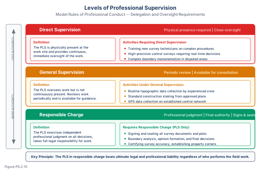
Levels of Supervision
Professional surveying recognizes different levels of supervision appropriate to different situations:
Direct Supervision
The licensed surveyor is personally present and actively directing the work. This level is appropriate for:
- Complex boundary determinations requiring real-time professional judgment
- Training new crew members on critical procedures
- Situations where immediate technical decisions are needed
- Work in areas with significant liability exposure
General Supervision
The licensed surveyor assigns work with instructions and reviews results, but is not continuously present. Appropriate for:
- Experienced crew performing routine measurements under established procedures
- Topographic surveys following standard protocols
- Construction staking from computed plans
- Data collection by trained technicians using approved methods
Responsible Charge Without Physical Presence
A surveyor can maintain responsible charge of work being performed at a remote location if:
- Clear, detailed instructions are provided before the work begins
- Communication is maintained during the work (phone, radio)
- The surveyor reviews and evaluates results before they are finalized
- The surveyor makes all professional judgments about the work
- The surveyor is available to respond to field questions and issues
Common wrong path — signing and sealing work you did not direct. A licensed surveyor cannot sign and seal a document based on another person's work — even another licensed surveyor's — unless the sealing surveyor exercised responsible charge over that work. "Responsible charge" requires actual direction and judgment, not just review of completed work. This rule most commonly appears when: (a) a license-holder is asked to "sign a plat prepared by [another licensee who has since left the firm]"; (b) a license-holder plans to seal work performed under a prior employer's supervision; (c) a license-holder wants to seal work done by an unlicensed subordinate with no direction from the licensee. All three are violations of most state surveying practice acts. The seal represents a professional warranty that the work was performed under the licensee's responsible charge. Exam questions test this by describing a scenario where a surveyor is asked to sign another's work; the correct response is to decline unless the signer actually directed the work.
Quick retrieval check — try before reading on.
▶A colleague at your firm was the surveyor of record for a boundary survey completed last month. They just left the firm and did not seal the final plat. The client is calling to ask for their sealed plat. The firm asks you, also a licensed surveyor, to sign and seal the plat since you're the only licensee available. Can you do so?
No — you cannot seal work you did not supervise. Even though you are a licensed surveyor and the work was performed by another licensed surveyor at your firm, you were not in responsible charge of the survey. Signing and sealing the plat would be a violation of the state surveying practice act and of professional ethics.
Professional options: (1) Ask the former employee to seal the plat before leaving the firm (typically the simplest solution); (2) personally redo the relevant portions of the survey under your own responsible charge — review the records, inspect the field evidence, verify the monumentation — before sealing; (3) perform a full peer-review equivalent redoing the work from scratch; (4) engage another surveyor (possibly the former employee as a subcontractor) to seal the work. Just slapping your seal on another's work to satisfy the client is a clear violation that exposes your license. If the firm pressures you to seal regardless, decline in writing and escalate to the appropriate authority within the firm or, if necessary, report the pressure to the state board. Your license is worth more than any single client relationship.
Field Documentation
Field Notes -- Fundamental Principles
Field notes are the contemporaneous record of observations made during survey work. They serve legal, technical, and historical purposes. The fundamental principles of field note keeping are:
| Principle | Application |
|---|---|
| Contemporaneous | Record observations at the time they are made, not later from memory |
| Complete | Include all information needed to reconstruct the survey |
| Accurate | Record exactly what was observed, not what was expected |
| Permanent | Use permanent media (ink, not pencil); never erase or destroy |
| Clear | Organized, legible, and understandable to other professionals |
| Objective | Record facts and observations, not unsupported conclusions |
Essential Field Note Content
| Category | Items to Document |
|---|---|
| Administrative | Date, weather, crew members, project name/number |
| Equipment | Instrument make/model/serial number, calibration date |
| Setup | Station description, instrument height, backsight reference |
| Observations | Raw angles, distances, rod readings, GPS data |
| Evidence | Monument descriptions (type, size, condition, markings), occupation evidence |
| Sketches | Sufficient detail to reconstruct the survey layout and feature relationships |
| Anomalies | Discrepancies, damaged monuments, unexpected conditions |
| Decisions | Choices made in the field and the reasoning behind them |
Monument Descriptions
Monument descriptions in field notes should include:
- Type and material (iron pipe, rebar, concrete, stone, etc.)
- Size (diameter, length)
- Condition (in place, tilted, broken, bent, loose)
- Cap or tag information (license number, name, designation)
- Surface features (flush, above grade, below grade, in pavement)
- References to nearby features (distances and directions to stable objects)
- Whether the monument was found, set, reset, replaced, or could not be found
Electronic Field Records
Modern data collectors store observations electronically. Documentation requirements for electronic records include:
| Requirement | Implementation |
|---|---|
| Backup | Daily download and backup of all data files |
| File naming | Consistent naming convention (project-date-crew-sequence) |
| Point numbering | Systematic numbering scheme documented in field book |
| Code list | Feature codes defined and provided to all crew members |
| Supplemental notes | Written field notes for evidence, descriptions, and sketches not captured electronically |
| Data integrity | Verify data completeness before leaving the field |
Office Documentation
Project Files
A complete project file should contain:
| Document | Purpose |
|---|---|
| Contract/proposal | Scope of work, client expectations, fee arrangement |
| Records research | Copies of recorded documents, title reports, prior surveys |
| Control data | Published and established control coordinates, datums |
| Field notes | Original field books, data collector downloads, backup copies |
| Computations | Traverse closures, adjustments, area calculations, coordinate computations |
| Correspondence | Letters, emails, and communications related to the project |
| Working maps | Draft versions showing development of the boundary opinion |
| Quality checks | Documentation of checks, reviews, and verification procedures |
| Final deliverables | Maps, plats, reports, legal descriptions issued to the client |
Computation Records
All computations should be documented to allow verification:
- Input data clearly identified
- Computation method stated
- Software used (name, version) documented
- Intermediate results shown
- Final results clearly stated
- Checks applied and documented
- Person performing computations identified
- Person checking computations identified (when applicable)
Record Retention
Surveying records must be retained for specified periods. Requirements vary by jurisdiction, but common standards include:
| Record Type | Typical Retention Period |
|---|---|
| Original field notes | Permanently (or as long as the firm exists) |
| Computations | Minimum 10 years (varies by jurisdiction) |
| Final maps and plats | Permanently |
| Correspondence | Minimum 5-10 years |
| Electronic data | Same as the paper equivalent |
Many professional liability policies require retention of records for the duration of the statute of limitations for professional negligence claims, which varies by jurisdiction but may extend 10 years or more from the date of discovery of an alleged error.
Disposition of Records
When a surveyor retires, dies, or closes a practice, the disposition of survey records is a matter of professional and often legal obligation:
- Records should be transferred to another licensed surveyor or professional entity
- Some jurisdictions require notification to the licensing board
- Records may be deposited with the county surveyor or other public repository
- Destruction of records before the retention period expires may constitute professional misconduct
Quality Management
Review Procedures
Professional quality management for survey documents includes:
| Review Type | Description |
|---|---|
| Self-review | The person who performed the work reviews it before passing it forward |
| Independent check | A second person verifies computations and evaluates results |
| Technical review | A senior surveyor reviews methodology, evidence analysis, and conclusions |
| Final review | The surveyor in responsible charge reviews and approves the final product |
Common Documentation Errors
| Error | Prevention |
|---|---|
| Missing monument descriptions | Use a checklist for each monument visited |
| Incomplete instrument information | Record equipment details at start of each session |
| Undocumented decisions | Note the reason for every field decision in real time |
| Insufficient sketches | Sketch before leaving each setup |
| Missing atmospheric data | Record temperature and pressure with each EDM setup |
| Inconsistent units | Establish unit convention at project start and document it |
Interim vs. Final Documents
The distinction between interim and final survey documents is important for both legal and practical reasons.
Interim Documents
- Marked "PRELIMINARY," "DRAFT," "FOR REVIEW ONLY," or similar notation
- Do not bear the surveyor's seal
- Used for internal review, client discussion, or agency review
- Subject to change based on review comments or additional information
- Should not be relied upon for legal, construction, or boundary purposes
Final Documents
- Bear the surveyor's seal, signature, and date
- Represent the surveyor's professional opinion at the time of issuance
- Suitable for recording, construction, legal proceedings, and reliance by third parties
- Must comply with all applicable standards, regulations, and professional requirements
- Cannot be modified without formal revision procedures (new seal, signature, date)
Exam Tips
- Responsible charge requires independent control and direction, not just review of completed work
- Field notes must be contemporaneous -- recorded at the time observations are made
- Monument descriptions in field notes should include type, size, condition, markings, and references
- Never erase or destroy original field notes; make corrections by striking through with a single line
- Electronic field data requires the same backup and documentation standards as paper records
- The surveyor in responsible charge must review and approve all final documents before sealing
- Interim documents must be clearly marked as preliminary and should not bear the surveyor's seal
- Record retention periods vary by jurisdiction but typically require permanent retention of field notes and final maps
- Quality management includes self-review, independent check, technical review, and final review
Related Test Topics
- Professional ethics and responsible charge (Module 1)
- Field techniques and measurement (Topic 2.2)
- Data collection and quality control (Topic 2.3)
- Maps, plats, and reports (Topic 2.8)
- Field communication (Topic 2.11)
- Record of survey requirements (Module 1)
Further Reading
Authoritative sources for deeper study
NCEES Model Rules of Professional Conduct (Aug 2025) — Model ethics, competence, and licensure rules adopted by most state boards.
Evidence and Procedures for Boundary Location (Robillard, Wilson, & Brown, 7th Ed.) — Practical treatise on collecting, weighing, and applying boundary evidence.
Wolf & Ghilani, Elementary Surveying — An Introduction to Geomatics (13th+ Ed.) — Comprehensive surveying text covering instruments, field procedures, and computations.
Last updated: 2026-04-17