PS Exam Preparation
Comprehensive preparation for the NCEES Principles and Practice of Surveying (PS) exam. 5 modules covering all 5 exam domains with 50 in-depth topics.
Module 1: Legal Principles
Module 2: Professional Survey Practices
Module 3: Standards & Specifications
Module 4: Business Practices
Module 5: Areas of Practice
Survey Maps, Plats & Reports
Learning Objectives
After completing this topic, you should be able to:
- Identify the required elements of a professional survey plat
- Describe the content and format requirements for boundary survey maps
- Explain ALTA/NSPS Land Title Survey requirements and standards
- Understand record of survey content and filing obligations
- Prepare written survey reports that document findings and opinions
- Distinguish between different map types and their purposes
- Apply proper cartographic standards for survey maps
Overview
Survey maps, plats, and reports are the primary deliverables of professional surveying. They communicate the results of field work, computations, and professional analysis to clients, agencies, attorneys, title companies, and future surveyors. The quality and completeness of these documents directly reflect the surveyor's competence and professionalism.
Each type of survey document serves a specific purpose and must meet specific content requirements. The professional surveyor must understand not only what information to include but how to present it clearly, unambiguously, and in compliance with applicable standards and regulations.
Key Concepts
Types of Survey Maps
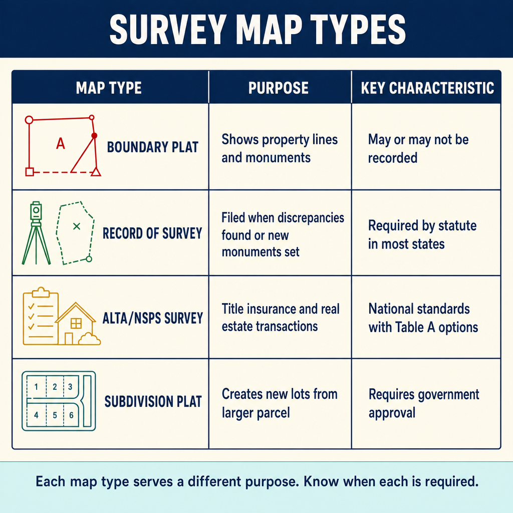
| Map Type | Purpose | Filing |
|---|---|---|
| Boundary survey plat | Depicts property boundaries, monuments, dimensions | Typically delivered to client, may trigger ROS |
| Record of survey | Documents field survey findings per statutory requirements | Filed with county surveyor/recorder |
| Subdivision map (tentative) | Proposes lot layout for agency review | Submitted to approving agencies |
| Subdivision map (final/parcel) | Creates legal subdivision, recorded document | Recorded with county recorder |
| ALTA/NSPS Land Title Survey | Comprehensive boundary/title survey for commercial transactions | Delivered to client, lender, title company |
| Topographic map | Shows ground surface configuration and features | Delivered to client, used for design |
| Construction survey plan | Shows staking and layout information | Used by construction team |
| As-built survey | Documents constructed improvements | Delivered to client and agencies |
Boundary Survey Plat Elements
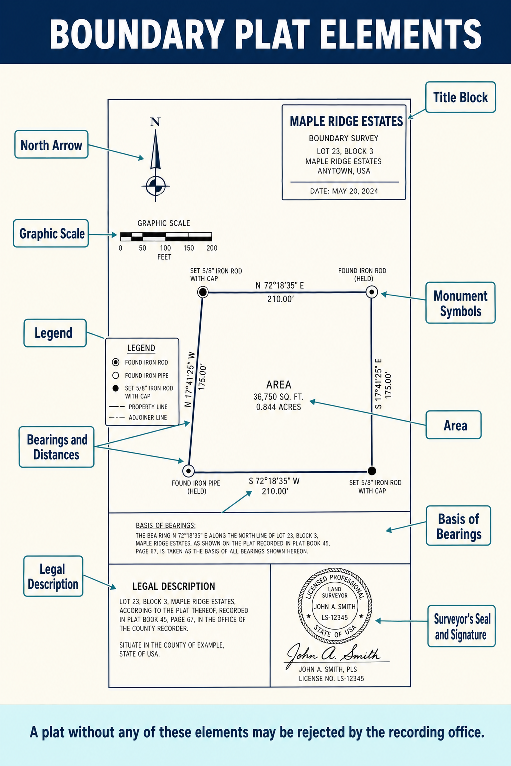
A professional boundary survey plat should contain, at minimum:
Title Block and Administrative Information
| Element | Description |
|---|---|
| Title | Clear identification of the survey type and property |
| Legal description | Complete legal description of the property surveyed |
| Client name | Name of the party who commissioned the survey |
| Surveyor information | Name, license number, seal, signature, date |
| Scale | Graphic and numeric scale |
| North arrow | Orientation reference with basis of bearings identified |
| Date of survey | Date(s) of field work |
| Sheet information | Sheet number of total sheets |
Technical Content
| Element | Description |
|---|---|
| Monuments found | Type, size, condition, and position of all monuments found |
| Monuments set | Type, size, and position of all monuments set |
| Boundary dimensions | Bearings and distances for all boundary lines |
| Curve data | Radius, arc length, chord bearing and distance, delta angle |
| Basis of bearings | Reference for all bearings shown (recorded map, GNSS, etc.) |
| Adjoining properties | Identification and relationship to adjacent parcels |
| Easements | Recorded easements affecting the property |
| Encroachments | Improvements or features crossing boundary lines |
| Area | Computed area of the property |
| Legend | Explanation of symbols used on the plat |
| Notes | Relevant information not otherwise shown graphically |
Cartographic Standards
Professional survey maps should follow accepted cartographic conventions:
| Convention | Standard |
|---|---|
| Line weights | Boundary lines heavier than topographic features; dimension lines lighter |
| Text orientation | Readable from bottom or right side of sheet |
| Monument symbols | Standardized symbols distinguishing found vs. set monuments |
| Curve data tables | Organized presentation of curve elements |
| Dimension placement | Bearing and distance along the line they describe |
| Scale selection | Sufficient to show all required detail legibly |
| Sheet size | Standard sizes per jurisdiction requirements |
ALTA/NSPS Land Title Surveys
The ALTA/NSPS Land Title Survey is governed by the jointly adopted standards of the American Land Title Association and the National Society of Professional Surveyors. These surveys serve commercial real estate transactions by providing comprehensive boundary, title, and site information.
Minimum Standard Detail Requirements
The current ALTA/NSPS standards require:
| Requirement | Description |
|---|---|
| Positional tolerance | Relative Positional Precision (RPP) of 2 cm (0.07 feet) + 50 ppm at 95% confidence for boundary points |
| Boundary | Complete boundary survey with dimensions and closure |
| Title commitment | Survey must reflect current title commitment or policy |
| Easements | All easements from the title commitment must be shown or noted |
| Evidence of possession | Fences, walls, hedges, occupation lines |
| Improvements | Buildings, structures, and other improvements on the property |
| Access | Evidence of access to public right-of-way |
| Rights of way | Adjacent streets, roads, and highways |
| Utilities | Observed utility features (poles, meters, manholes) |
| Certification | Specific certification language to named parties |
Table A Optional Items
The ALTA/NSPS standards include Table A, a list of optional items that may be requested by the client, lender, or title company. Selected examples:
| Item | Description |
|---|---|
| Zoning | Current zoning classification, setback requirements, compliance |
| Flood zone | Flood zone designation and base flood elevation |
| Parking | Number and type of parking spaces |
| Wetlands | Wetland delineation or identification |
| Offsite easements | Easements benefiting the property but located on adjacent land |
| Building areas | Gross building area, floor area |
| Height | Building height per local code definition |
| Utilities | Underground utilities from plans and/or utility locate |
| Exterior dimensions | Measured exterior building dimensions |
ALTA/NSPS Certification
The survey must contain a specific certification identifying the surveyor, the client, and any other parties to whom the survey is certified (lender, title company, etc.). The certification attests that the survey was prepared in accordance with the minimum standard detail requirements.
Record of Survey
The record of survey (ROS) is a filed document that serves the public interest by documenting survey evidence and findings. While specific requirements vary by jurisdiction, the ROS generally must show:
Content Requirements
| Element | Description |
|---|---|
| All monuments | Found, set, reset, replaced, or removed -- with type, size, and location |
| Bearing and distance | For all surveyed lines |
| Basis of bearings | Reference for directional measurements |
| Relationship to adjacent surveys | Connection to adjoining recorded maps and surveys |
| Property identification | Legal description and/or assessor parcel number |
| Date of survey | When the field work was performed |
| Surveyor seal, signature, date | Authentication by the responsible surveyor |
| Filing trigger | Statement explaining why the ROS is required |
| Coordinate system | Grid coordinates if applicable |
Filing Procedures
The typical ROS filing process:
- Surveyor prepares the map in compliance with format requirements
- Map is submitted to the county surveyor for review
- County surveyor examines the map for compliance and technical accuracy
- Corrections are made if needed
- County surveyor accepts the map (or issues certificate of acceptance)
- Map is filed with the county recorder and assigned a recording number
- A copy is retained in the county surveyor's files
Survey Reports
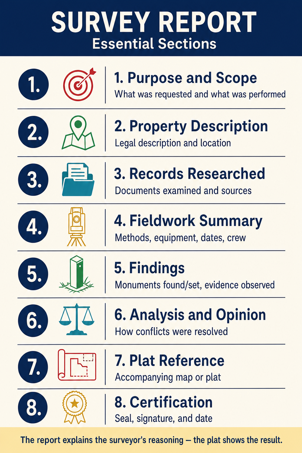
Written survey reports provide narrative documentation of the surveyor's findings, analysis, and opinions. While a map or plat conveys the graphic results, the report explains the reasoning and evidence behind the boundary determination.
Report Components
| Component | Content |
|---|---|
| Purpose and scope | What was the survey commissioned to accomplish |
| Records research | Documents examined, sources consulted, findings |
| Field evidence | Monuments found, condition, agreement with records |
| Analysis | How evidence was weighed, discrepancies resolved, boundary established |
| Opinion | The surveyor's professional opinion on boundary locations |
| Exceptions and qualifications | Limitations on the survey, unresolved issues, areas not surveyed |
| Encumbrances | Easements, encroachments, and other conditions affecting the property |
| Recommendations | Suggested actions (monument setting, further research, quiet title) |
When Reports Are Needed
Written reports are particularly valuable for:
- Complex boundary determinations with conflicting evidence
- Properties with significant encroachments or disputes
- ALTA/NSPS surveys with extensive title exceptions
- Surveys where the boundary opinion may be challenged
- Retracement surveys in areas with inadequate monumentation
- Expert witness situations where the surveyor's reasoning must be documented
Common wrong path — ALTA certification can be modified to protect the surveyor. The ALTA/NSPS certification language is prescribed by the standards and cannot be materially modified without losing the "ALTA/NSPS" label. Surveyors occasionally try to add disclaimers like "to the best of my knowledge" or "subject to verification of the title commitment" — language intended to reduce personal exposure. Those additions usually invalidate the ALTA certification: the title company won't accept it, the client won't get title insurance relying on it, and the entire point of an ALTA survey is compromised. The correct approach: meet the ALTA minimum standards, certify in the prescribed language, and manage liability through insurance (E&O) and contract (limitation of liability), NOT through certification modifications. Exam questions test this by showing a scenario where a surveyor adds disclaiming language; the correct response is that the modification defeats the purpose of the ALTA certification.
Quick retrieval check — try before reading on.
▶A client asks you to certify an ALTA/NSPS survey to them, their lender, and the title company, but specifies that the certification should state "to the best of my knowledge and belief, subject to the surveyor's assumptions regarding record data." Can you comply with this request?
No — that modification substantially weakens the certification and likely invalidates it as an ALTA/NSPS-compliant document. The prescribed ALTA/NSPS certification language is not aspirational or suggested — it is what an "ALTA/NSPS Land Title Survey" means. The title company and lender rely on that specific language to extend title insurance coverage based on the survey; adding "to the best of my knowledge and belief" converts the certification from a warranty to an opinion, and the title insurer may refuse to provide survey-related coverage.
Professional response: (1) Explain to the client that the prescribed certification is a condition of ALTA/NSPS compliance; (2) offer to perform the survey to the standards and certify in the prescribed form; (3) manage liability through your professional liability (E&O) insurance and a contractual limitation of liability clause with the client; (4) if the client insists on modified certification language, clarify that the product will not be an ALTA/NSPS survey and should not be represented as such. Changing the certification is not a compromise — it eliminates the ALTA/NSPS status of the deliverable.
Map Drafting and Presentation
Digital Drafting Standards
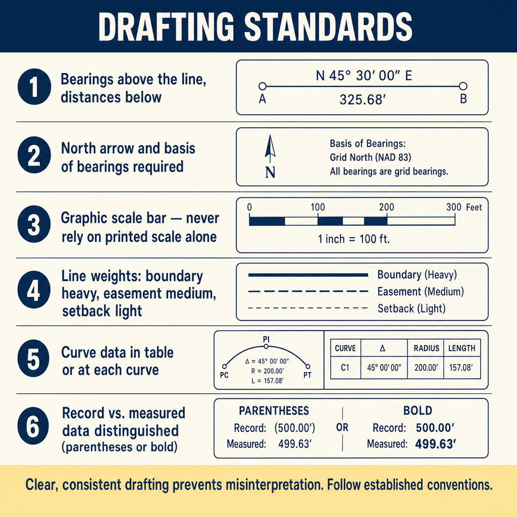
Modern survey maps are prepared digitally using CAD software. Professional standards require:
- Consistent use of layers for different types of information
- Standard line types (solid for boundaries, dashed for easements, etc.)
- Appropriate text sizes for legibility at the plotted scale
- Clean, uncluttered presentation with logical information hierarchy
- Compliance with jurisdictional format requirements (sheet size, margins, title block location)
Common Symbols
Survey maps use standardized symbols that should be defined in a legend:
| Symbol | Meaning |
|---|---|
| Solid circle | Monument found |
| Open circle | Monument set |
| Triangle | Control point |
| Square | Calculated position (not monumented) |
| Cross in circle | Section corner |
| Dashed line | Easement |
| Chain line | Centerline |
| Crosshatch | Building footprint |
Symbol conventions vary by region and firm. The critical requirement is that all symbols used on the map are defined in the legend.
Quality Control for Deliverables
Before issuing any survey document, the surveyor should verify:
- Mathematical closure of all boundary traverses
- Consistency between legal description and graphic depiction
- Agreement between dimensions on the map and computed values
- Correct identification of all monuments (found vs. set, type, and condition)
- Complete showing of all easements from the title commitment (for ALTA/NSPS)
- Proper seal, signature, and date
- Compliance with all format and content requirements
- Legibility at the plotted scale
- Correct basis of bearings and coordinate references
Exam Tips
- ALTA/NSPS surveys require a Relative Positional Precision (RPP) of 2 cm (0.07 feet) + 50 ppm at 95% confidence
- The basis of bearings must always be stated on a survey map
- Records of survey must identify why filing is required (the statutory trigger)
- Found monuments and set monuments should be clearly distinguished using different symbols
- Survey reports are essential for documenting the reasoning behind boundary opinions
- All symbols on a map must be defined in a legend
- Easements from the title commitment must be shown or addressed on an ALTA/NSPS survey
- The surveyor's seal and signature authenticate the document and represent professional responsibility
Related Test Topics
- Record of survey filing requirements (Module 1)
- Monumentation standards (Topic 2.6)
- Subdivision maps and land development (Topic 2.7)
- CAD and drafting software (Topic 2.12)
- GIS and coordinate systems (Topic 2.9)
- Documentation and supervision (Topic 2.10)
- Boundary law and evidence (Module 1)
Further Reading
Authoritative sources for deeper study
2021 ALTA/NSPS Land Title Survey Standards — Current minimum standard detail requirements for ALTA/NSPS land title surveys.
Wattles, Writing Legal Descriptions (1976) — Gold-standard reference on metes-and-bounds, sectional, and combination descriptions.
Brown's Boundary Control and Legal Principles (7th Ed., Robillard & Wilson) — Standard textbook on boundary law, evidence hierarchy, and retracement.
Wolf & Ghilani, Elementary Surveying — An Introduction to Geomatics (13th+ Ed.) — Comprehensive surveying text covering instruments, field procedures, and computations.
Last updated: 2026-04-17