PS Exam Preparation
Comprehensive preparation for the NCEES Principles and Practice of Surveying (PS) exam. 5 modules covering all 5 exam domains with 50 in-depth topics.
Module 1: Legal Principles
Module 2: Professional Survey Practices
Module 3: Standards & Specifications
Module 4: Business Practices
Module 5: Areas of Practice
National Map Accuracy Standards
Learning Objectives
After completing this topic, you should be able to:
- Explain the purpose and history of the US National Map Accuracy Standards (NMAS)
- State the horizontal accuracy requirements for large-scale and small-scale maps
- State the vertical accuracy requirement and its relationship to the contour interval
- Calculate the allowable positional error for a map at a given scale
- Describe how accuracy testing is performed under NMAS
- Explain the limitations of NMAS and why newer standards have been developed
- Distinguish between NMAS and FGDC/NSSDA accuracy standards
Overview
The United States National Map Accuracy Standards (NMAS) were established in 1947 by the U.S. Bureau of the Budget to provide a uniform set of accuracy standards for maps produced by federal agencies. Despite being over 75 years old, NMAS remains widely used in surveying practice and is one of the most frequently tested accuracy standards on the PS exam.
NMAS defines minimum accuracy requirements for both horizontal positions and vertical elevations on maps, based on the map scale and contour interval. Understanding these standards is essential for specifying map accuracy requirements, evaluating map products, and answering exam questions.
Key Concepts
Background and Purpose
History:
- Originally issued in 1941, revised in 1943 and 1947
- Published by the U.S. Bureau of the Budget (now the Office of Management and Budget)
- Established as a standard for maps produced by federal agencies
- Widely adopted by state and local governments and the private sector
- Formally titled "United States National Map Accuracy Standards"
Purpose:
- Provide a consistent definition of "accuracy" for maps
- Allow map users to understand the positional reliability of map features
- Enable comparison of maps from different sources
- Establish testing procedures for accuracy evaluation
- Create a pass/fail standard for map compliance
Horizontal Accuracy Standard
NMAS defines two horizontal accuracy thresholds based on map scale:
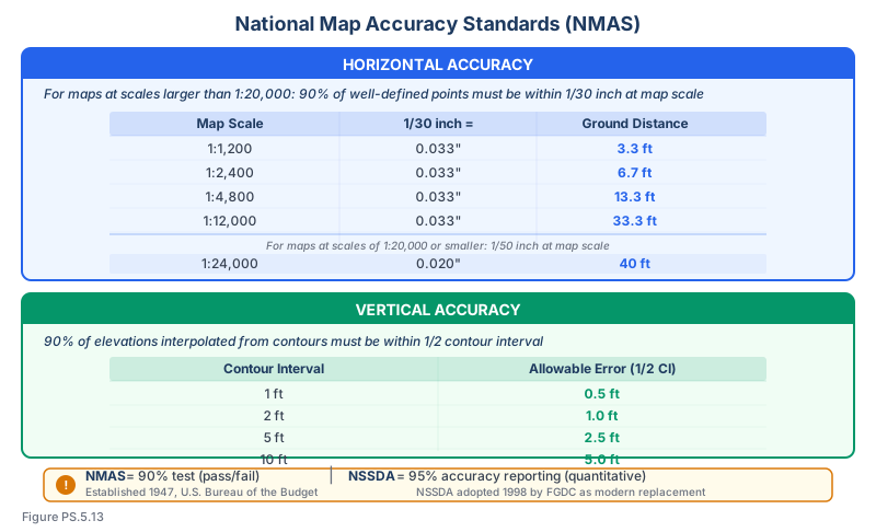
For maps at scales larger than 1:20,000 (large-scale maps):
- Not more than 10% of well-defined points tested shall be in error by more than 1/30 inch measured at publication scale
- Equivalently: 90% of well-defined points must be within 1/30 inch of their true position at map scale
For maps at scales of 1:20,000 or smaller (small-scale maps):
- Not more than 10% of well-defined points tested shall be in error by more than 1/50 inch measured at publication scale
- Equivalently: 90% of well-defined points must be within 1/50 inch of their true position at map scale
Calculating ground accuracy from map scale:
For large-scale maps (>1:20,000): Ground accuracy = (1/30 inch) x Scale denominator
For small-scale maps (1:20,000 or smaller): Ground accuracy = (1/50 inch) x Scale denominator
Example calculations for large-scale maps:
| Map Scale | 1/30 inch on map = | Ground Accuracy |
|---|---|---|
| 1 inch = 10 feet (1:120) | 0.033 inch | 0.33 feet |
| 1 inch = 20 feet (1:240) | 0.033 inch | 0.67 feet |
| 1 inch = 40 feet (1:480) | 0.033 inch | 1.33 feet |
| 1 inch = 50 feet (1:600) | 0.033 inch | 1.67 feet |
| 1 inch = 100 feet (1:1,200) | 0.033 inch | 3.33 feet |
| 1 inch = 200 feet (1:2,400) | 0.033 inch | 6.67 feet |
| 1 inch = 400 feet (1:4,800) | 0.033 inch | 13.33 feet |
| 1 inch = 1,000 feet (1:12,000) | 0.033 inch | 33.33 feet |
Example calculations for small-scale maps:
| Map Scale | 1/50 inch on map = | Ground Accuracy |
|---|---|---|
| 1:20,000 | 0.020 inch | 33.33 feet |
| 1:24,000 (USGS 7.5-min quad) | 0.020 inch | 40.00 feet |
| 1:50,000 | 0.020 inch | 83.33 feet |
| 1:100,000 | 0.020 inch | 166.67 feet |
Vertical Accuracy Standard
The NMAS vertical accuracy standard:
- Not more than 10% of elevations tested shall be in error by more than one-half the contour interval
- Equivalently: 90% of elevation points tested must be within 1/2 of the contour interval of their true elevation
Example calculations:
| Contour Interval | Maximum Error (90% of points) |
|---|---|
| 1 foot | 0.5 feet |
| 2 feet | 1.0 feet |
| 5 feet | 2.5 feet |
| 10 feet | 5.0 feet |
| 20 feet | 10.0 feet |
| 40 feet | 20.0 feet |
Important notes about the vertical standard:
- Applies to well-defined points (not interpolated contour positions)
- Testing is performed at points where elevation can be independently verified
- The standard applies to the terrain surface, not to contour line positions directly
- Heavily vegetated or obscured areas may require relaxed criteria
Testing Procedures
How NMAS accuracy is tested:
- Select a representative sample of well-defined points on the map
- Determine the "true" positions of these points using methods at least three times more accurate than the map standard
- Compare the map positions to the true positions
- Count the number of points exceeding the accuracy threshold
- If 10% or fewer points exceed the threshold, the map passes
"Well-defined points":
- Points that can be precisely identified on both the map and the ground
- Examples: road intersections, building corners, property corners, survey monuments
- Excludes features with ambiguous boundaries (edge of vegetation, approximate shorelines)
Testing sample size:
- NMAS does not specify a minimum sample size
- Common practice: minimum 20 points for meaningful statistical evaluation
- Points should be distributed across the map area, not concentrated in one location
Scale and Accuracy Relationship
A fundamental principle: larger scale maps have higher ground accuracy.
This is counterintuitive because "larger scale" means a larger representative fraction (1:100 is larger than 1:10,000), which means the map shows a smaller area in more detail.
| Comparison | Scale | Detail | Ground Accuracy (1/30 inch) |
|---|---|---|---|
| Larger scale | 1:600 (1 in = 50 ft) | More detail | 1.67 feet |
| Smaller scale | 1:12,000 (1 in = 1,000 ft) | Less detail | 33.33 feet |
Limitations of NMAS
NMAS has several limitations that led to the development of newer standards:
Binary pass/fail:
- A map either passes or fails -- there is no graduated reporting of accuracy
- A map that barely passes and one that greatly exceeds the standard receive the same designation
No confidence level:
- The 90% threshold does not correspond to a standard statistical confidence level
- Modern standards use the 95% confidence level, which is the standard in geodetic practice
No positional uncertainty reporting:
- NMAS does not require reporting the actual accuracy achieved
- Users cannot determine whether a passing map is accurate to 1/30 inch or 1/100 inch
No methodology for digital data:
- NMAS was written for paper maps
- Digital mapping and GIS products require different accuracy assessment methods
- The concept of "publication scale" is less meaningful for digital data that can be displayed at any zoom level
Circular error assumption:
- NMAS treats horizontal error as circular (same in all directions)
- Actual errors may be directional (elliptical), which the standard does not capture
Common wrong path — "larger scale" and "larger area" in the same sentence. Map scale terminology confuses students routinely. Larger scale = smaller representative fraction denominator = less area covered per inch = more detail. So 1:600 is a larger scale than 1:24,000, even though 1:600 shows a smaller area. Students who conflate "larger scale" with "covers more area" or "shows more ground" reverse the relationship. When the exam asks about accuracy at a "larger scale" map, it is asking about the more detailed (higher accuracy) map. The test: if scale A has denominator 1,200 and scale B has denominator 24,000, scale A (1:1,200) is larger. NMAS accuracy at 1:1,200 is 3.33 ft ground; at 1:24,000 it is 40 ft ground. The larger-scale map is more accurate. Always parse the denominator first before claiming which scale is larger.
Quick retrieval check — try before reading on.
▶You have two maps of the same area: Map A at 1:2,400 and Map B at 1:12,000. Which map has better ground accuracy under NMAS, and what is the ground accuracy of each?
Map A (1:2,400) has better ground accuracy. It is the larger scale (smaller denominator → more detail per inch of map).
Both are large-scale maps (>1:20,000), so the 1/30 inch threshold applies:
- Map A: 1/30 inch × 2,400 = 80 inches = 6.67 ft ground accuracy
- Map B: 1/30 inch × 12,000 = 400 inches = 33.33 ft ground accuracy
Map A is 5× more accurate on the ground than Map B — because Map A covers a smaller area at a more detailed scale. Students sometimes answer "Map B, because it's bigger" (meaning it shows more area) — wrong. The "large" in "large scale" refers to the scale number, not the area shown. This terminology is counterintuitive but universal in cartography and surveying.
NMAS vs. NSSDA
The National Standard for Spatial Data Accuracy (NSSDA), published by FGDC, addresses many NMAS limitations:
| Characteristic | NMAS | NSSDA |
|---|---|---|
| Year | 1947 | 1998 |
| Confidence level | 90% (informal) | 95% |
| Reporting | Pass/fail | Actual accuracy value |
| Basis | Map scale | Ground units |
| Method | Percent exceeding threshold | RMSE-based |
| Digital data | Not addressed | Designed for digital and analog |
| Still widely used | Yes (surveying industry) | Yes (federal agencies, GIS) |
See Topic 5.14 for detailed coverage of FGDC and NSSDA standards.
Exam Tips
- Memorize the core NMAS thresholds: Large scale (>1:20,000): 90% within 1/30 inch; Small scale: 90% within 1/50 inch; Vertical: 90% within 1/2 contour interval
- The scale break point is 1:20,000 -- at exactly 1:20,000 and smaller, use 1/50 inch; larger than 1:20,000, use 1/30 inch
- Be able to quickly calculate ground accuracy: multiply 1/30 inch (0.0333 inch) by the scale denominator and convert to feet
- For a 1:1,200 scale map: 0.0333 x 1,200 = 40 inches = 3.33 feet
- For USGS 7.5-minute quadrangle maps (1:24,000): 0.020 x 24,000 = 480 inches = 40 feet
- Vertical accuracy: if the contour interval is 2 feet, 90% of tested elevations must be within 1 foot
- NMAS is pass/fail; NSSDA reports actual accuracy values at 95% confidence
- Testing requires independent measurements at least 3 times more accurate than the standard
- "Well-defined points" must be clearly identifiable on both the map and the ground
- Larger scale (e.g., 1:600) means higher accuracy and more detail; smaller scale (e.g., 1:24,000) means lower accuracy and less detail
Related Test Topics
- Geospatial accuracy standards -- NSSDA and FGDC (Topic 5.14)
- Topographic and planimetric mapping (Topic 5.7)
- Control networks for mapping accuracy (Topic 5.2)
- ALTA/NSPS survey accuracy -- RPP (Topic 5.1)
- Hydrographic and remote sensing surveys (Topic 5.8)
- Construction surveys and tolerance requirements (Topic 5.4)
Further Reading
Authoritative sources for deeper study
FGDC Geospatial Positioning Accuracy Standards — National standard for positional accuracy reporting (NSSDA).
Snyder, USGS Bulletin 1532 — Map Projections Used by the USGS — Mathematical treatment of common map projections (Lambert Conformal Conic, Transverse Mercator, etc.).
Wolf & Ghilani, Elementary Surveying — An Introduction to Geomatics (13th+ Ed.) — Comprehensive surveying text covering instruments, field procedures, and computations.
Last updated: 2026-04-17