PS Exam Preparation
Comprehensive preparation for the NCEES Principles and Practice of Surveying (PS) exam. 5 modules covering all 5 exam domains with 50 in-depth topics.
Module 1: Legal Principles
Module 2: Professional Survey Practices
Module 3: Standards & Specifications
Module 4: Business Practices
Module 5: Areas of Practice
Riparian, Littoral & Sovereign Rights
Learning Objectives
After completing this topic, you should be able to:
- Distinguish between riparian and littoral rights
- Define accretion, erosion, reliction, and avulsion and their effects on property boundaries
- Explain the doctrine of navigability and its importance to boundary location
- Identify when the thread of the stream versus the bank is the boundary
- Describe sovereign (public trust) rights in navigable waters
- Understand eminent domain and its relationship to property rights
- Apply water boundary principles to survey scenarios
Overview
Water boundaries present some of the most complex legal issues in surveying. Unlike fixed boundaries defined by monuments and measurements, water boundaries are ambulatory -- they move with the water. The doctrines governing water boundaries have developed over centuries of common law and vary significantly between jurisdictions, between navigable and non-navigable waters, and between gradual and sudden changes.
The surveyor working with water boundaries must understand not only the physical behavior of water features but also the legal doctrines that determine who owns what when water and land interact. These principles affect property rights along rivers, streams, lakes, oceans, and tidal waters.
Key Concepts
Riparian vs. Littoral Rights
These terms describe the rights of landowners whose property borders water:
| Term | Water Type | Examples | Boundary Location |
|---|---|---|---|
| Riparian | Flowing water | Rivers, streams, creeks | Thread of the stream (non-navigable) or bank/high-water mark (navigable) |
| Littoral | Standing/tidal water | Lakes, oceans, seas, tidal areas | High-water mark or meander line |
Riparian rights include:
- Right to access the water from the adjacent land
- Right to reasonable use of the water (domestic, irrigation, etc.)
- Right to accretions (gradual additions to the bank)
- Right to undiminished water flow (in riparian doctrine states)
- Right to wharf out to navigable depth (in some jurisdictions)
Littoral rights include:
- Right to access the water
- Right to accretions formed along the shore
- Right to relicted land (exposed by gradual recession)
- Right to reasonable use of the adjacent waters
The Four Doctrines of Water-Caused Land Changes
1. Accretion
Accretion is the gradual and imperceptible addition of soil to the bank of a river or shore of a lake or ocean by natural causes (water current, wave action, wind-blown sediment). The deposited soil is called alluvion.
Legal effect: The accreted land becomes the property of the riparian or littoral owner. The boundary moves with the accretion.
Key requirements:
- The deposit must be gradual and imperceptible (not the result of a sudden event)
- The deposit must be by natural causes (not artificial fill)
- The deposit must be on the owner's bank or shore
- The accretion must be permanent or semi-permanent
Why the law awards accretion to the riparian owner: The principle is one of fairness. The riparian owner bears the risk of erosion (losing land gradually), so the law compensates by awarding accretion. Additionally, denying the accretion to the riparian owner would create a gap between the owner's land and the water, severing the valuable riparian access right.
2. Erosion
Erosion is the gradual wearing away of soil by the action of water, wind, or other natural forces.
Legal effect: The owner loses title to the eroded land. The boundary moves landward with the erosion. There is no compensation for the loss.
Key characteristics:
- Must be gradual and imperceptible
- Operates as the inverse of accretion
- The former owner has no claim to recover the lost soil
- The boundary follows the changed bank or shoreline
3. Reliction (Dereliction)
Reliction is the gradual recession or withdrawal of water, uncovering land that was formerly submerged. This can occur due to natural changes in water level, course changes, or climate effects.
Legal effect: The exposed land becomes the property of the riparian or littoral owner, similar to accretion.
Requirements:
- The recession must be gradual (not sudden)
- The recession must appear permanent (not seasonal fluctuation)
- The water must have been the boundary
Example: A lake gradually recedes over decades, exposing a strip of dry land along its former shore. The littoral owners along that shore acquire title to the newly exposed land, extending their boundary to the new water's edge.
4. Avulsion
Avulsion is a sudden and perceptible change in the course of a river or the position of a shoreline, caused by flood, storm, earthquake, or other violent natural event.
Legal effect: The boundary does NOT move. The boundary remains at the location of the former bank or shoreline before the avulsion occurred.
This is the critical distinction:
| Change | Speed | Boundary Effect |
|---|---|---|
| Accretion | Gradual | Boundary moves with the accretion |
| Erosion | Gradual | Boundary moves with the erosion |
| Reliction | Gradual | Boundary moves to the new waterline |
| Avulsion | Sudden | Boundary stays at the old location |
Why avulsion differs: The law distinguishes between gradual and sudden changes because gradual changes allow the surveyor and the parties to track the boundary over time. A sudden change -- a river jumping its channel overnight during a flood, for example -- would instantly redistribute vast amounts of property if the boundary moved with it. The law avoids this injustice by holding the boundary at the pre-avulsion location.
After avulsion, the affected owner has:
- A reasonable time to reclaim the land (in river course changes)
- The right to the land at the former boundary location
- No automatic loss or gain from the sudden change
Navigability and Its Importance
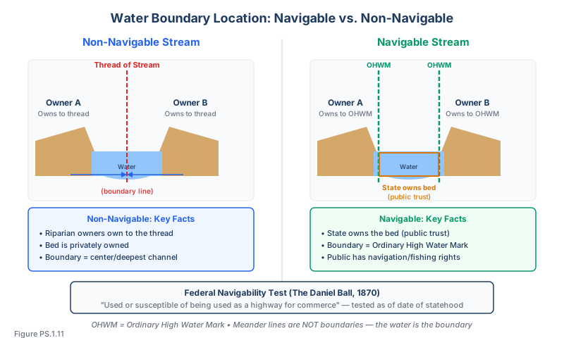
The concept of navigability is critical to water boundary law because it determines:
- Who owns the bed of the waterway (the state or the riparian owner)
- Where the boundary is located (thread of the stream or bank/high-water mark)
- What public rights exist (navigation, fishing, recreation)
Federal Test of Navigability
Under the federal test (established in The Daniel Ball, 1870), a waterway is navigable if it is:
"Used, or susceptible of being used, in its ordinary condition, as a highway for commerce over which trade and travel are or may be conducted in the customary modes of trade and travel on water."
Key aspects:
- The test is applied as of the date of statehood
- The waterway need not have been actually used for commerce -- susceptibility is sufficient
- Log floating counts as commerce in many jurisdictions
- Recreational use alone may not establish navigability under the federal test
State Tests of Navigability
States may have broader definitions of navigability for purposes of state law. Some states declare waters navigable if they are:
- Capable of floating a log or canoe
- Used for recreational boating
- Subject to tidal influence
- Large enough to support fish or wildlife habitat
Ownership of the Bed
| Water Type | Bed Ownership | Boundary Location |
|---|---|---|
| Navigable river | State (public trust) | Ordinary high-water mark |
| Non-navigable river | Riparian owners (to the thread) | Thread of the stream |
| Navigable lake | State (public trust) | Ordinary high-water mark or meander line |
| Non-navigable lake | Littoral owners (to center in some states) | Varies by jurisdiction |
| Tidal waters | State (below mean high tide) | Mean high-tide line |
| Ocean | State/Federal | Mean high-tide line |
Thread of the Stream
The thread of the stream may refer to either the thalweg (line of deepest channel) or the medial line (equidistant between banks). These are often different lines, especially in meandering streams. Jurisdictions vary on which definition applies. For non-navigable streams where the riparian owner holds to the thread, this line is the boundary between properties on opposite banks.
Determining the thread:
- Follow the deepest channel (thalweg) where determinable
- Use the equidistant line between the banks as a practical alternative
- The thread moves with gradual changes in the stream course
- Islands in the stream are allocated to the owner on whose side they fall
Sovereign Rights and the Public Trust Doctrine
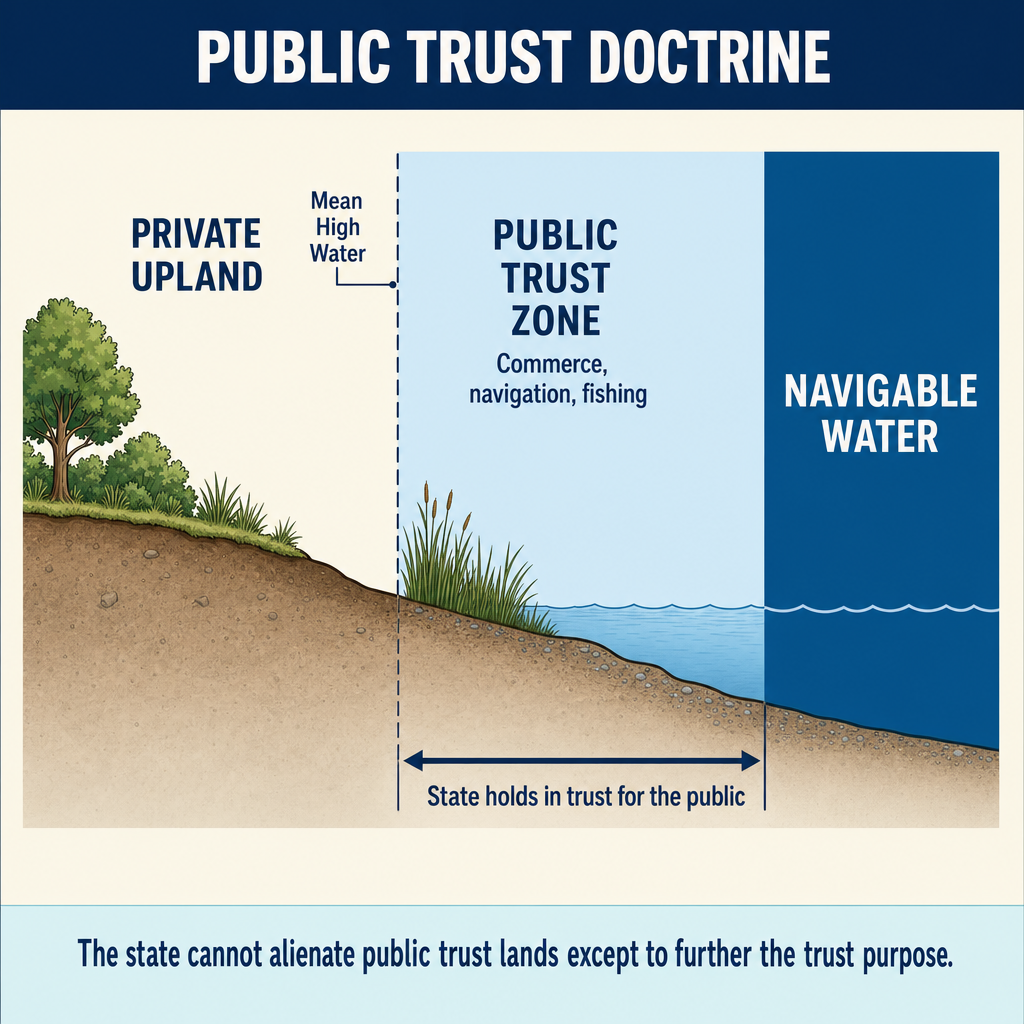
The public trust doctrine holds that the state holds title to the beds of navigable waters and tidal lands in trust for the public. This doctrine limits private property rights along navigable waterways.
Public trust rights include:
- Navigation
- Commerce
- Fishing
- Recreation (in most modern interpretations)
Implications for surveyors:
- The boundary of private property along navigable waters is the ordinary high-water mark, not the water's edge
- The state owns the bed and submerged lands below the ordinary high-water mark
- Private landowners cannot exclude the public from navigable waters
- Filled lands in navigable waters may still be subject to the public trust
Eminent Domain
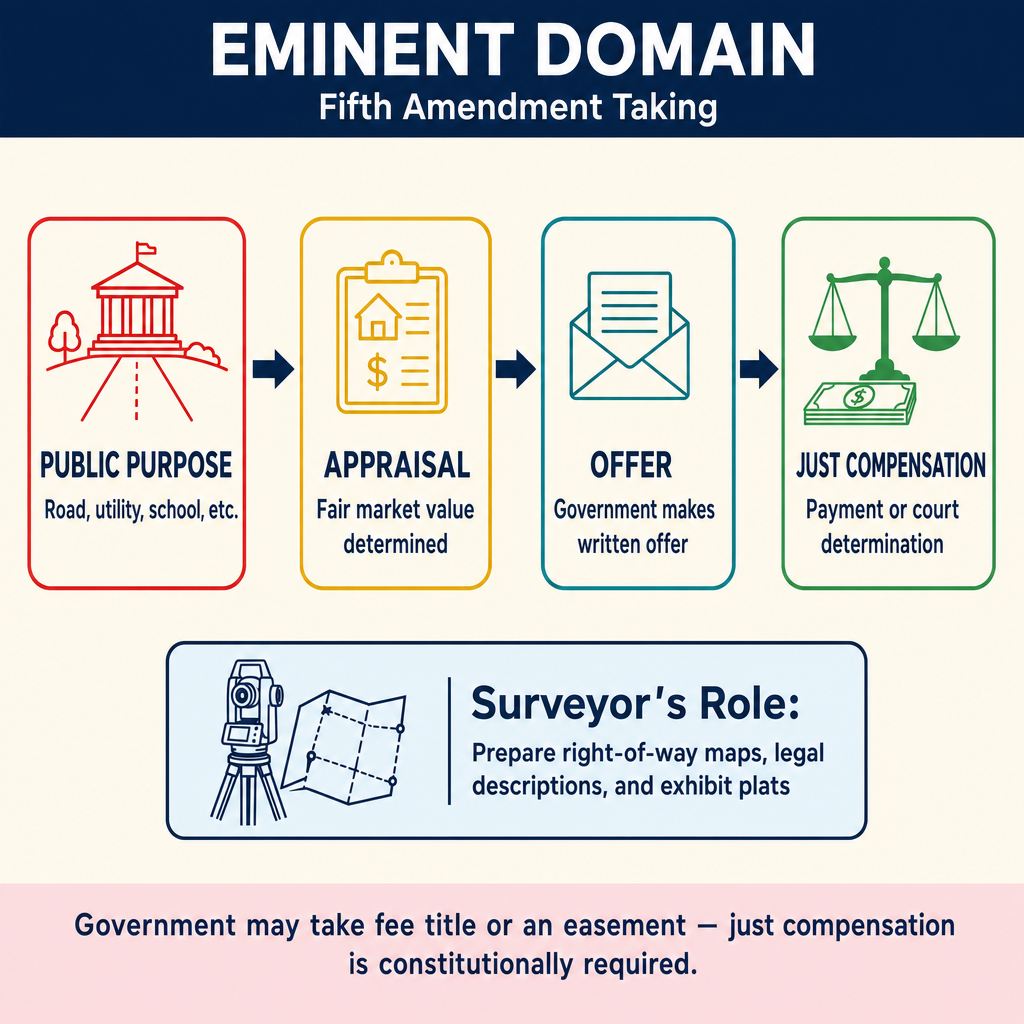
Eminent domain is the government's power to take private property for public use upon payment of just compensation. While not exclusively a water boundary concept, it is closely related because:
- Governments frequently condemn easements for flood control, navigation, and water management
- Riparian and littoral rights may be taken or modified through eminent domain
- Navigational servitudes may allow government action without compensation in some cases
Requirements for eminent domain:
- The taking must be for a public use (broadly defined)
- Just compensation must be paid
- Due process must be followed
- The power extends to all interests in land (fee title, easements, water rights)
Inverse condemnation occurs when government action effectively takes property without formal condemnation proceedings. The owner must sue to recover compensation.
Meander Lines in Government Surveys
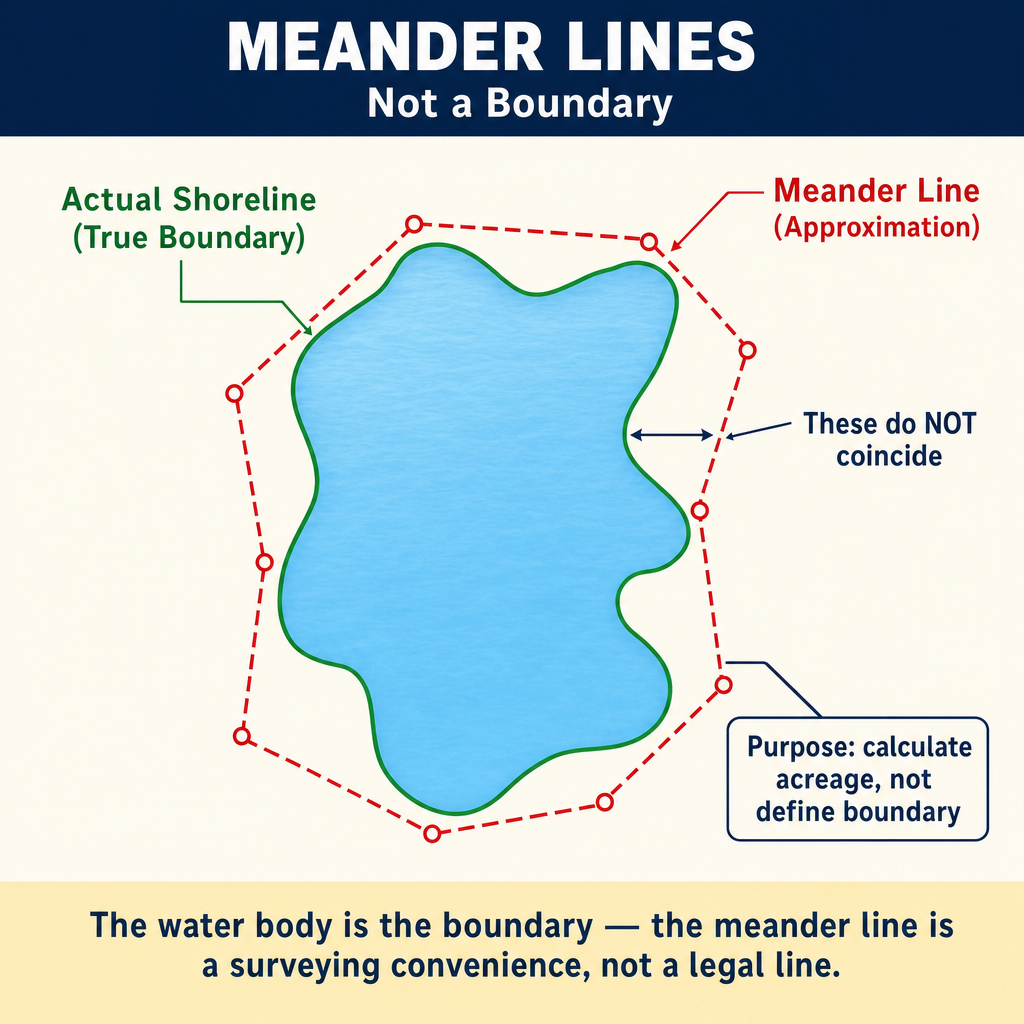
Meander lines were run by the original GLO surveyors along the banks of navigable rivers and lakes. These lines are not boundaries -- they are approximations of the water's edge used for calculating areas.
Critical rule: The meander line is not the boundary. The water itself is the boundary. The meander line merely approximates where the water was at the time of the survey. If the water has moved gradually, the boundary moves with it. If the water has moved suddenly (avulsion), the boundary remains at the former position.
Exception: When the meander line and the actual water boundary are so far apart that the omitted lands between them constitute a separate parcel, courts have sometimes held the meander line as the boundary. This is the doctrine of omitted lands and it applies in very limited circumstances.
Common wrong path — swapping thread and high-water mark. Two different boundary rules coexist for waterways, and the exam mercilessly tests which one applies:
- Non-navigable stream → riparian owners hold to the thread of the stream (centerline or thalweg). The state does NOT own the bed.
- Navigable waterway → the state owns the bed in trust for the public; private ownership extends only to the ordinary high-water mark. No one holds "to the thread" on a navigable river.
Students often apply "thread of the stream" to all rivers, or "high-water mark" to all waters. Neither is right. The correct answer always depends first on navigability under the applicable test (federal, for federal land disputes; state, for many state-law boundary cases). Determine navigability, then apply the matching boundary rule. Getting this wrong inverts the answer — putting the state's bed interest on a private owner's parcel, or vice versa.
Quick retrieval check — try before reading on.
▶A 1962 deed describes property "bounded on the west by the east bank of the Willow River." The river was non-navigable under both federal and state tests at the time of statehood. Over 60 years of gradual erosion, the east bank has retreated 40 ft. Where is the western boundary now?
Since the Willow River is non-navigable, the riparian owner holds to the thread of the stream — not to the bank. The deed's language "east bank of the Willow River" appears to describe the east bank as the boundary, but as a matter of law for non-navigable streams in most jurisdictions, the true boundary extends to the thread (or thalweg) — the deed's bank language is interpreted as a reference to where the water was, with the legal boundary at the centerline. Because the erosion was gradual, the boundary moves with the water: the new thread (after 40 ft of east-bank retreat) is now farther west than the original thread. The owner's property has grown by half the erosion distance (about 20 ft, assuming the west bank didn't also move). This is a classic exam trap — candidates often stop at "the east bank moved 40 ft, so the boundary moved 40 ft," forgetting that for non-navigable streams the boundary is the thread, not the bank. Note: if the river had been navigable, the bank/OHWM would be the correct boundary and erosion would reduce the owner's land by the full 40 ft.
Subsurface and Mineral Rights
Water rights are not the only rights that can be severed from the surface estate. The mineral estate may be split from the surface by a grant of the minerals alone or by a reservation in a deed that conveys the surface but retains the minerals. Once severed, the mineral estate is a distinct interest in real property that can be sold, leased, and inherited separately — and the surveyor must expect the record chain for the minerals to diverge from the chain for the surface. A reservation of mineral rights, like any reservation in a grant, is generally interpreted in favor of the grantor who made it — the reverse of the usual rule favoring the grantee.
On mining claims located under federal mining law, ownership of a vein is not confined to vertical planes at the claim boundaries. An extralateral right is "the right to follow the downward course of a vein, with certain limitations, to the end of its depth" (Brown's Boundary Control and Legal Principles, 7th Ed., §7.29). The limitations are:
- The apex of the vein must lie within the boundaries of the claim
- Only the dip (downward course) of the vein may be followed — not its strike
- The direction followed must stay within the end lines of the claim extended vertically and outward
- The vein must travel through land open to location
The practical effect is striking: the owner of a lode claim may mine a vein far beyond the claim's side lines — beneath a neighbor's land — so long as the vein's apex is inside the claim. Mineral surveys of lode claims are among the special surveys of the public lands, and retracing them requires understanding these rights.
Practical Application for Surveyors
When surveying properties along water:
- Determine navigability -- this controls ownership of the bed and boundary location
- Identify the type of water body -- river, lake, tidal, ocean
- Locate the ordinary high-water mark -- for navigable waters and tidal boundaries
- Determine the thread -- for non-navigable streams
- Investigate historical changes -- was the change gradual (accretion/erosion/reliction) or sudden (avulsion)?
- Research meander lines -- for PLSS lands, the meander line is not the boundary
- Document current conditions with photographs and measurements
- Note the date of the survey -- water conditions on the survey date are relevant
Exam Tips
- Accretion = gradual deposit = boundary moves; Avulsion = sudden change = boundary stays
- Riparian refers to flowing water (rivers/streams); littoral refers to standing/tidal water (lakes/oceans)
- The thread of the stream is the boundary for non-navigable streams where the riparian owner holds to the center
- For navigable waters, the state owns the bed, and the boundary is the ordinary high-water mark
- Meander lines are NOT boundaries -- the water is the boundary
- Erosion causes the owner to lose land (the boundary retreats); accretion causes the owner to gain land (the boundary advances)
- Reliction = water recedes gradually = owner gains the exposed land
- The navigability test is applied as of the date of statehood (federal test)
- Government cannot adversely possess, but it can take by eminent domain with just compensation
- Know the distinction between gradual and sudden -- this determines whether the boundary moves
- Public trust doctrine gives the public rights in navigable waters (navigation, fishing, commerce, recreation)
Related Test Topics
- Controlling Elements (Topic 1.5)
- Legal Descriptions (Topic 1.9)
- PLSS Perpetuation (Topic 1.10)
- Searching and Evaluating Evidence (Topic 1.1)
- Easement Rights (Topic 1.6)
Further Reading
Authoritative sources for deeper study
Shalowitz & Reed, Shore and Sea Boundaries (Vols. 1–3, NOAA) — Definitive U.S. reference on water-boundary law and tidal datums.
Brown's Boundary Control and Legal Principles (7th Ed., Robillard & Wilson) — Standard textbook on boundary law, evidence hierarchy, and retracement.
Clark, A Treatise on the Law of Surveying and Boundaries — Long-standing legal reference on boundary disputes and surveyor liability.
Last updated: 2026-04-17