PS Exam Preparation
Comprehensive preparation for the NCEES Principles and Practice of Surveying (PS) exam. 5 modules covering all 5 exam domains with 50 in-depth topics.
Module 1: Legal Principles
Module 2: Professional Survey Practices
Module 3: Standards & Specifications
Module 4: Business Practices
Module 5: Areas of Practice
Monumentation Standards & Types
Learning Objectives
After completing this topic, you should be able to:
- Distinguish between natural and artificial monuments and their evidentiary weight
- Identify common monument types used in professional surveying
- Explain the legal hierarchy of boundary evidence as it relates to monuments
- Describe monument setting standards including materials, marking, and placement
- Understand perpetuation requirements for existing monumentation
- Apply the doctrine of monuments over other boundary evidence
- Determine when monument rehabilitation or replacement is appropriate
Overview
Monumentation is the physical manifestation of surveying work on the ground. While computations exist on paper and coordinates exist in databases, monuments are the tangible markers that property owners, future surveyors, and the public rely upon to identify boundary locations. The professional surveyor must understand not only the technical standards for setting monuments but also the legal principles that govern their evidentiary weight.
The treatment of monuments in law reflects centuries of property jurisprudence. Courts have consistently held that physical monuments on the ground carry greater weight than written dimensions, courses, or areas in resolving ambiguities in property descriptions. This principle, while subject to important exceptions, is fundamental to boundary law and survey practice.
Key Concepts
Natural vs. Artificial Monuments
The distinction between natural and artificial monuments is one of the most important concepts in boundary surveying.
Natural Monuments
Natural monuments are physical features that exist in nature, not placed by human hands for survey purposes. Examples include:
| Natural Monument | Characteristics |
|---|---|
| Rivers and streams | Ambulatory (may shift over time); thalweg or thread of stream |
| Lakes and ponds | Water's edge at ordinary high or low water |
| Ridgelines | Topographic divides between drainage basins |
| Rock outcrops | Permanent, identifiable geological features |
| Trees (witness/bearing) | Specifically identified trees called for in descriptions |
| Bays, harbors, shorelines | Subject to tidal and erosion changes |
| Springs | Point features, relatively stable |
| Cliffs and bluffs | Prominent topographic features |
Natural monuments are generally given the highest evidentiary weight because they are considered the most reliable indicators of the grantor's intent. They were visible at the time of the original conveyance and presumably influenced the parties' understanding of the property boundaries.
However, natural monuments can be problematic:
- Ambulatory boundaries (rivers, streams) may shift over time through accretion or avulsion
- Destruction by natural forces or human activity may eliminate the monument
- Ambiguity in identifying the specific feature called for in the description
Artificial Monuments
Artificial monuments are physical objects placed by human hands. They fall into two categories:
Monuments placed as survey markers:
| Monument Type | Material | Typical Use |
|---|---|---|
| Iron pipe/rod | Iron, steel, rebar | Property corners, lot corners |
| Cap and tag | Brass, aluminum, or plastic cap on pipe/rod | Identification with surveyor's license number |
| Concrete monument | Concrete with embedded marker | Section corners, major boundaries |
| Stone monument | Cut stone or natural stone with markings | Historical surveys, GLO corners |
| Nail and shiner | Masonry nail with aluminum disc | Corners in pavement |
| Axle | Old vehicle axle | Older surveys, section corners |
| P-K nail | Brass or aluminum nail | Property corners in hard surfaces |
| Railroad spike | Steel spike | Temporary or rural markers |
Monuments of occupation and improvement:
| Feature | Evidentiary Role |
|---|---|
| Fence lines | May indicate practical boundary location or acquiescence |
| Walls | Stone walls, retaining walls as boundary evidence |
| Buildings | Corners or edges called for as boundary reference |
| Roads and streets | Centerline, edge, or right-of-way as boundary reference |
| Hedgerows | Living fence lines as evidence of boundary location |
| Irrigation ditches | Channels as boundary features |
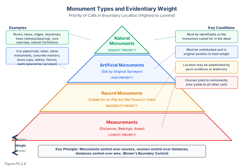
Legal Hierarchy of Boundary Evidence
Courts have established a general hierarchy for resolving conflicts in boundary descriptions. While the hierarchy varies somewhat by jurisdiction and circumstance, the generally accepted order from highest to lowest priority is:
- Natural monuments -- rivers, lakes, ridges, marked trees
- Artificial monuments -- stakes, pipes, stones, and other markers called for in the description
- Adjoiners and adjoining boundaries -- references to neighboring properties
- Courses (bearings/directions) -- the directions of boundary lines
- Distances -- the lengths of boundary lines (some authorities rank distances above directions — the relative priority depends on the survey methods used and the jurisdiction; see Topic 1.5)
- Area (quantity) -- the stated acreage or square footage
This hierarchy is a guideline for resolving ambiguities, not an absolute rule. The fundamental principle is to determine the intent of the parties at the time of the original conveyance. If a lower-priority element more clearly reflects the parties' intent, it may prevail over a higher-priority element.
Monuments and Deed Interpretation
Monuments Set Prior to Deed
When monuments are set before a deed is written and the deed refers to those monuments, the monuments are considered part of the deed. The deed describes the monuments as they exist on the ground, and the physical position of the monuments controls over written dimensions that may conflict.
This is a critical principle: a monument set prior to the deed and referenced in the deed is presumed superior to courses and distances that conflict with it. The theory is that the grantor intended to convey the land as delineated by the monuments the parties observed, not as might be computed from imperfect written measurements.
Monuments Set After Deed
When monuments are set after a deed is written (such as when a surveyor later stakes a boundary based on the deed description), these monuments do not carry the same evidentiary weight. They represent one surveyor's interpretation of the written description, not the original grantor's intent. They are presumed subordinate to the deed language they purport to interpret.
Common wrong path — giving "set after deed" monuments full hierarchy weight. Not every found monument earns the top of the evidence hierarchy. The rule is: monuments called for in the deed AND set contemporaneously (before or at the time of the original conveyance) take priority over measurements. Monuments set later — by a subsequent surveyor retracing the deed — are interpretations, not original evidence. They can be wrong, they can be displaced, they can reflect flawed reasoning by the later surveyor. Students sometimes treat every rebar or iron pipe on the property as a controlling monument; the exam tests this by describing a "found monument" whose pedigree is unclear or whose date of placement post-dates the deed. Check monument age, pedigree, and whether the deed references it — without that linkage, it is evidence of occupation or of a prior surveyor's opinion, not of the original boundary.
Quick retrieval check — try before reading on.
▶An 1890 deed calls for "N 45° E, 500 ft to a stone post" between two parcels. You find three objects near the expected corner: (a) a weathered stone post that matches the description, (b) a 1975 rebar with a PLS tag, and (c) a 2015 iron pipe with a cap noting "corrected position." Which controls?
The stone post (a) — it is the monument called for in the 1890 deed and matches the description. Its pedigree traces to the original conveyance. Under the hierarchy, an original called-for monument controls over measurements and over any subsequently set monument. The 1975 rebar (b) is almost certainly a later surveyor's attempt to perpetuate or reinterpret the corner; it has no independent authority beyond whatever evidence it documented. The 2015 pipe (c) is explicitly labeled as "corrected" — meaning the placing surveyor believed the existing monuments were wrong and asserted a new position. That unilateral assertion does not override the original evidence. If the stone post is undisturbed and clearly the called-for monument, it controls; the rebar and pipe should be documented on your plat as found (with dates and ownership) but treated as subordinate. Only if the stone post's pedigree or condition is in doubt do the later monuments become relevant.
However, monuments set after a deed can gain evidentiary significance through:
- Long acquiescence -- when property owners treat the monumented line as the boundary for an extended period
- Subsequent conveyances -- when later deeds reference the monuments
- Estoppel -- when parties have relied on the monumented position to their detriment
Lost and Obliterated Monuments
The distinction between lost and obliterated monuments has significant legal consequences:
| Classification | Definition | Treatment |
|---|---|---|
| Obliterated | Monument no longer visible but its position can be recovered from related evidence (witnesses, measurements, accessories) | Position is restored from available evidence |
| Lost | Monument whose position cannot be determined from any evidence | Position must be reestablished by proportionate measurement or other legal method |
For GLO/PLSS corners, the BLM Manual of Surveying Instructions provides detailed procedures for restoring obliterated corners and reestablishing lost corners, including single and double proportionate measurement.
Monument Setting Standards
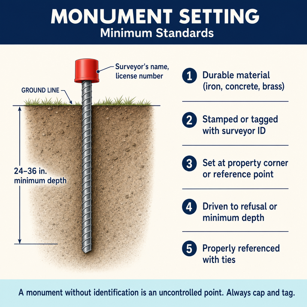
Materials and Durability
Professional monuments must be:
- Durable -- resistant to corrosion, weathering, and physical damage
- Stable -- not subject to displacement by frost heave, settlement, or disturbance
- Identifiable -- clearly marked as survey monuments
- Recoverable -- capable of being found by future surveyors
Modern standards generally require:
| Standard | Requirement |
|---|---|
| Material | Iron pipe, rebar, or equivalent durable material |
| Minimum size | Typically 1/2-inch to 1-inch diameter (varies by jurisdiction) |
| Minimum length | Typically 18-30 inches (varies by jurisdiction) |
| Marking | Identification cap with surveyor's license number |
| Setting depth | Sufficient to resist displacement (typically below frost line) |
Cap and Tag Requirements
Most jurisdictions require that monuments set by a licensed surveyor bear a cap or tag with:
- The surveyor's license number preceded by "LS" or "PLS" (or equivalent state designation)
- The surveyor's name or firm name (in some jurisdictions)
- The designation "PLS" or similar professional title
Most state surveying practice acts require that any monument set by a licensed land surveyor be permanently and visibly marked or tagged with the surveyor's license number and professional designation (e.g., "PLS" or "LS").
Placement Criteria
Monuments should be set at:
- All property corners
- All angle points in the boundary
- Points of curvature and tangency on curved boundaries
- Intersections of boundaries with roads, easements, and other features
- Sufficient intermediate points along long lines to facilitate future recovery
Placement considerations:
| Factor | Guidance |
|---|---|
| Visibility | Place where reasonably findable by future surveyors |
| Stability | Avoid fill areas, unstable slopes, construction zones |
| Protection | Consider surface markers, guard stakes, or witness monuments |
| Accessibility | Balance between security and recoverability |
| Depth | Below frost line in cold climates, below typical disturbance depth |
Perpetuation of Monuments
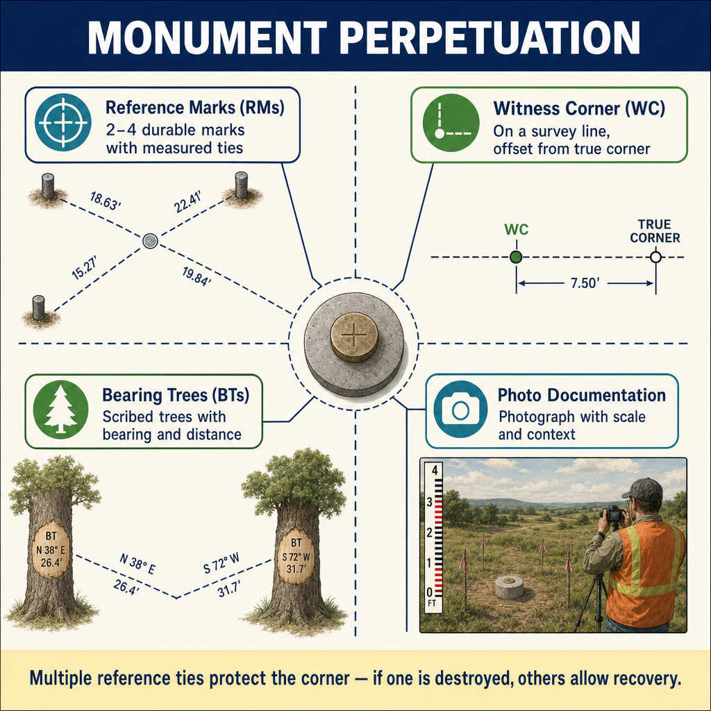
The obligation to perpetuate existing monumentation is both a legal requirement and a professional responsibility.
Pre-Construction Reference
Before any construction activity that may disturb or destroy monuments, the surveyor must:
- Locate all existing monuments in the project area
- Reference each monument to stable features outside the construction zone
- File a corner record or record of survey documenting the references
- Replace or reset monuments after construction is complete
- File documentation of the replacement
This requirement applies to all types of construction, including road work, utility installation, grading, and building construction.
Witness Monuments
When a monument cannot be set at the exact boundary position (due to an obstruction, pavement, or other impediment), a witness monument is set nearby. The witness monument must:
- Be clearly marked as a witness monument (not the actual corner)
- Have a documented relationship to the actual corner position (bearing and distance)
- Be placed where it is reasonably secure from disturbance
Reference Points
Reference points (sometimes called ties or accessories) are measurements from a monument to nearby stable features that help in relocating the monument if it becomes obscured or disturbed. Standard practice is to:
- Reference each monument to at least two stable features
- Record references as bearing and distance
- Select features that are likely to remain stable (buildings, utility structures, large trees)
- Include references on the record of survey or corner record
Monument Rehabilitation
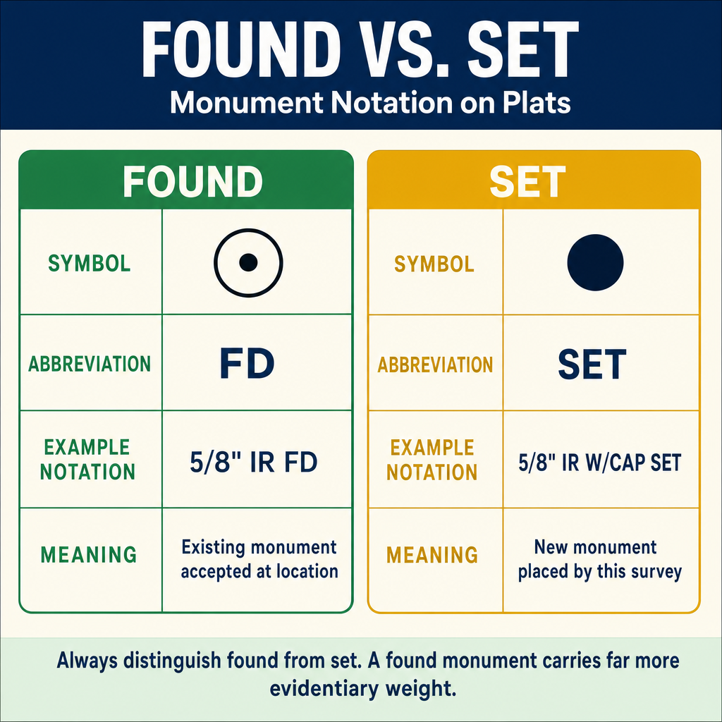
When a surveyor finds an existing monument that is damaged, tilted, partially exposed, or otherwise compromised, the decision to rehabilitate, reset, or replace it requires careful judgment:
| Condition | Action | Documentation |
|---|---|---|
| Undisturbed, in good condition | Leave in place, reference | Corner record |
| Tilted but at original position | May straighten carefully, reference | Corner record noting condition |
| Displaced from original position | Do not use as control; reset based on evidence | Record of survey |
| Partially destroyed but identifiable | Reference, protect, consider replacement | Corner record or record of survey |
| Missing but position recoverable | Reset monument at recovered position | Record of survey |
Exam Tips
- Natural monuments are generally given higher evidentiary weight than artificial monuments in boundary disputes
- Monuments set prior to a deed and referenced in it are considered part of the deed
- Monuments set after a deed represent the surveyor's interpretation and are subordinate to the deed language
- The hierarchy of boundary evidence (monuments, adjoiners, courses, distances, area) is a guide to determine intent, not an absolute rule
- An obliterated monument can be restored from evidence; a lost monument must be reestablished
- Most states require monuments to be marked with the surveyor's license number and professional designation
- Pre-construction monument referencing and post-construction replacement are mandatory obligations
- Witness monuments are used when the actual corner position cannot be monumented
Related Test Topics
- Boundary law principles and evidence hierarchy (Module 1)
- Record of survey requirements (Module 1)
- Corner records and documentation (Topic 2.10)
- Field techniques for monument search (Topic 2.2)
- Public Land Survey System monument standards
- Legal descriptions and calls to monuments
Further Reading
Authoritative sources for deeper study
BLM Manual of Surveying Instructions (2009), Ch. III — Standards for execution of public-land surveys.
Brown's Boundary Control and Legal Principles (7th Ed., Robillard & Wilson) — Standard textbook on boundary law, evidence hierarchy, and retracement.
Evidence and Procedures for Boundary Location (Robillard, Wilson, & Brown, 7th Ed.) — Practical treatise on collecting, weighing, and applying boundary evidence.
Last updated: 2026-04-17