PS Exam Preparation
Comprehensive preparation for the NCEES Principles and Practice of Surveying (PS) exam. 5 modules covering all 5 exam domains with 50 in-depth topics.
Module 1: Legal Principles
Module 2: Professional Survey Practices
Module 3: Standards & Specifications
Module 4: Business Practices
Module 5: Areas of Practice
Types of Surveys & Scope of Services
Learning Objectives
After completing this topic, you should be able to:
- Identify the major types of land surveys and their defining characteristics
- Determine the appropriate survey type for a given client need
- Prepare a scope of services document for various survey types
- Recognize site features that influence scope and methodology
- Select appropriate equipment based on project requirements
- Distinguish between surveys requiring a licensed surveyor and those that do not
Overview
Professional surveyors perform a wide variety of survey types, each with distinct purposes, standards, deliverables, and client expectations. Understanding these differences is critical for writing accurate proposals, managing client expectations, and delivering appropriate work products. The PS exam tests your ability to match survey types to client needs, define complete scopes of service, and identify the equipment and methods suited to each type.
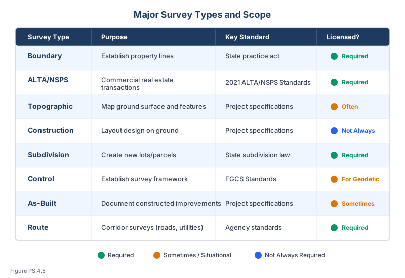
Major Survey Types
Boundary Surveys
Purpose: Establish or reestablish the location of property boundaries on the ground.
Key Characteristics:
- Requires licensed surveyor in all jurisdictions
- Based on legal principles, not just measurement
- Involves research, field evidence collection, and professional judgment
- Results in monuments set at boundary corners
- May require filing of a survey plat or map with the appropriate authority
Typical Deliverables:
- Survey plat showing found and set monuments
- Bearing and distance of all boundary lines
- Basis of bearings
- Area calculation
- Adjoining owner information
- Notes regarding encroachments, overlaps, or gaps
- Filed survey map (Record of Survey, plat, or equivalent)
When Required:
- Property transfers requiring certainty of boundaries
- Fence line disputes
- Construction near property lines
- Subdivision of land
- Adverse possession or boundary line agreement documentation
ALTA/NSPS Land Title Surveys
Purpose: Provide title insurance companies and lenders with a survey that meets the minimum standard detail requirements adopted jointly by ALTA and NSPS.
Key Characteristics:
- Must comply with the current ALTA/NSPS Minimum Standard Detail Requirements
- Includes boundary determination plus additional items
- Requires coordination with the title commitment or report
- Surveyor must certify compliance with the standards
- Client specifies optional "Table A" items
Standard Requirements (beyond a boundary survey):
- All buildings, structures, and visible improvements
- Evidence of utilities (above and below ground)
- Recorded easements shown or noted
- Access to a public right-of-way
- Zoning classification with setback requirements (if Table A Item 6 selected)
- Flood zone determination (if Table A Item 8 selected)
- Relationship between boundary and possession lines
Table A Optional Items (selected examples):
| Item | Description |
|---|---|
| 1 | Monuments placed or to be placed at all major boundary corners |
| 2 | Address(es) of surveyed property |
| 3 | Flood zone designation with FIRM community/panel number and date |
| 5 | Vertical relief with source of benchmark and datum |
| 6 | (a) Current zoning classification with setback requirements; (b) Zoning compliance |
| 8 | Substantial visible features within 5 feet of each side of boundary |
| 11 | Location of wetland areas as delineated by qualified specialist |
| 19 | Professional liability insurance disclosure |
Topographic Surveys
Purpose: Map the physical features of a site including elevation data for use in engineering design.
Key Characteristics:
- Focused on existing conditions, not legal boundaries
- Contour lines at specified interval (typically 1-foot or 2-foot)
- Spot elevations at critical features
- Location of all visible improvements
- Tree locations with species and size (when specified)
- Utility features (manholes, valves, poles, meters)
Typical Parameters to Define in Scope:
| Parameter | Options |
|---|---|
| Contour interval | 0.5-foot, 1-foot, 2-foot, 5-foot |
| Accuracy | Based on ASPRS or project-specific standards |
| Extent | Property limits, specified area, or offset from centerline |
| Feature level | Basic improvements only, detailed utilities, vegetation inventory |
| Datum | NAVD 88, local, project-specific |
| Deliverable format | Hard copy, CAD file, GIS file, LiDAR point cloud |
Construction Surveys
Purpose: Translate design plans into physical positions in the field for construction.
Types of Construction Surveys:
| Type | Application |
|---|---|
| Layout/staking | Marking proposed positions of structures, roads, or utilities |
| Grade staking | Providing cut/fill information for earthwork |
| As-built surveys | Documenting constructed conditions vs. design |
| Monitoring | Tracking movement or settlement during construction |
| Machine control | Providing 3D surface models for automated equipment |
Key Considerations:
- Accuracy requirements vary by construction type
- Coordination with contractor schedules is essential
- Staking may need to be repeated if disturbed
- As-built surveys document deviations from design
Control Surveys
Purpose: Establish a network of precisely positioned reference points for subsequent surveys and mapping.
Key Characteristics:
- Provides the framework on which all other surveys are based
- Requires higher accuracy than most project surveys
- Tied to national datums (NAD 83, NAVD 88) or state coordinate systems
- May involve static GNSS observations, precise leveling, or both
Accuracy Standards:
| Order | Horizontal (1 sigma) | Vertical (1 sigma) | Typical Use |
|---|---|---|---|
| First Order | 1:100,000 | 0.5 mm x sqrt(km) | National geodetic network |
| Second Order, Class I | 1:50,000 | 1.0 mm x sqrt(km) | Regional control, large projects |
| Third Order | 1:10,000 | 2.0 mm x sqrt(km) | Local project control |
Subdivision Surveys
Purpose: Divide a parent parcel into two or more smaller parcels in compliance with applicable regulations.
Key Characteristics:
- Subject to local subdivision regulations and state law
- Requires boundary determination of the parent parcel
- Lot design must meet zoning, setback, and access requirements
- Requires filing of a subdivision plat or map
- May require coordination with planning, engineering, and legal professionals
Common Requirements:
- Lot dimensions and areas
- Street widths and alignments
- Utility easements
- Drainage easements
- Monument placement at all lot corners
- Compliance with local plat standards
Route Surveys
Purpose: Survey along a linear corridor for transportation, utility, or pipeline projects.
Key Characteristics:
- Alignment defined by horizontal and vertical curves
- Cross-sections at regular intervals
- Right-of-way boundaries may need to be established
- May require extensive easement research
- Often involves coordination with multiple property owners and agencies
Hydrographic Surveys
Purpose: Map the bottom of water bodies for navigation, dredging, or engineering purposes.
Key Characteristics:
- Uses specialized equipment (echo sounders, multibeam sonar)
- Tidal or river stage corrections required
- Accuracy standards per USACE or IHO specifications
- May require vessel positioning via GNSS
- Results in bathymetric contour maps
Scope of Services Documents
Writing an Effective Scope
A well-written scope of services answers five questions:
- What will be done (tasks and deliverables)
- Where the work will be performed (property identification)
- How the work will be performed (methods and standards)
- When the work will be completed (schedule)
- What is excluded (limitations and assumptions)
Common Scope Pitfalls
| Pitfall | Consequence | Prevention |
|---|---|---|
| Vague deliverables | Client expects more than intended | List deliverables specifically |
| Missing exclusions | Client assumes items are included | State exclusions explicitly |
| No standards reference | Dispute over quality | Reference applicable standards |
| Open-ended site features | Scope expands to cover unforeseen items | Define feature collection limits |
| No change process | Unauthorized scope additions | Include change order procedure |
Site Features That Influence Scope
The following site conditions should be evaluated during scope development:
| Feature | Impact on Scope |
|---|---|
| Terrain | Steep or heavily vegetated sites require more field time and may limit equipment choices |
| Access | Restricted access may require special arrangements, permits, or additional mobilizations |
| Existing improvements | Dense improvements increase data collection time |
| Vegetation | Heavy canopy affects GNSS availability; dense brush requires clearing |
| Utilities | Complex utility networks add significant data collection time for topographic surveys |
| Water features | Streams, ponds, and wetlands require specialized methods |
| Hazardous conditions | Contaminated sites require special safety measures |
Equipment Selection
Equipment by Survey Type
| Survey Type | Primary Equipment | Support Equipment |
|---|---|---|
| Boundary | Total station, GNSS RTK | Prism poles, range poles, iron pipe detector |
| ALTA/NSPS | Total station, GNSS RTK | Same as boundary plus utility locator |
| Topographic | GNSS RTK, total station, scanner | Data collector, UAV (for large sites) |
| Construction | Total station, GNSS RTK | Machine control systems, laser levels |
| Control | GNSS static, digital levels | Forced centering equipment, calibrated rods |
| Hydrographic | Echo sounder, multibeam | GNSS positioning, tide gauge |
Equipment Selection Factors
When selecting equipment for a project, consider:
- Accuracy requirements -- Does the project require sub-centimeter positioning or is decimeter sufficient?
- Site conditions -- Is there clear sky view for GNSS? Are there reflective surfaces for EDM?
- Production rate -- How many points per hour are needed to meet the schedule?
- Data format -- What format does the client or design team require?
- Availability -- Is the equipment available when needed, or does it need to be rented?
Common wrong path — accepting a "topo only" scope when boundaries are at stake. Clients sometimes request a "simple topographic survey" when what the project really needs includes boundary determination — for example, a topo for design of improvements that must meet setback requirements, or for a lot that's about to be subdivided. Accepting a topo-only scope in those circumstances exposes the surveyor to liability: the design relies on property-line positions, but the topo did not actually determine them. The professional response is to inform the client when the project's use of the topo implies a boundary determination, and scope a combined survey accordingly. Exam questions test this by describing a scope request that is labeled one way but functionally requires another type — the correct answer is to expand the scope to match the project's actual needs, not to deliver exactly what the client asked for if it's insufficient.
Quick retrieval check — try before reading on.
▶A developer asks for "just a topographic survey" of a 5-acre parcel to support design of a new building. During the initial conversation you learn the building will include zoning-required setbacks from the property lines. Can you deliver a topographic survey alone, or should the scope include boundary determination?
Include boundary determination. The building design must comply with setback requirements, which are measured from property lines. A topographic survey alone shows features and elevations but does not authoritatively determine where the property lines are — meaning the setback analysis would be based on approximate, uncertified boundary positions. If the building is later found to violate setbacks because the topo-based property lines were inaccurate, the surveyor is exposed to liability even though the delivered product was "just a topo."
The correct scope: deliver a combined boundary and topographic survey with monuments at boundary corners, certified boundary positions, topographic features, and building setback lines clearly shown. Discuss with the developer that the lower-cost "topo only" option is inappropriate given the project's intended use. Document the conversation and get the expanded scope authorized in writing. The developer may grumble about the higher fee, but the alternative is either a defective deliverable or future liability from a setback violation — neither of which serves the surveyor's or the developer's long-term interests.
Surveys Requiring a Licensed Surveyor
Generally Require a License
- Boundary surveys and retracements
- ALTA/NSPS Land Title Surveys
- Subdivision surveys and plats
- Any survey that determines property boundaries
- Surveys that will be filed as public records
- Surveys that affect property rights or interests
May Not Require a License (Varies by Jurisdiction)
- Topographic surveys for engineering design (when not establishing boundaries)
- Construction staking from engineer-provided coordinates
- Photogrammetric mapping (in some jurisdictions)
- GIS data collection for planning purposes
The distinction varies significantly by state. The Model Law provides guidance, but state practice acts govern.
Exam Tips
- Know the defining characteristics that distinguish each survey type
- ALTA/NSPS survey questions frequently appear -- know the standard requirements vs. Table A optional items
- Understand that equipment selection depends on accuracy requirements and site conditions, not just preference
- Scope of services questions test whether you can identify missing or ambiguous elements
- Construction survey questions may test your understanding of the difference between layout staking, grade staking, and as-built surveys
- Remember that boundary determination is always a licensed surveyor function
Related Test Topics
- Project Planning and Management (Topic 4.1)
- Costs, Budgets, and Contracts (Topic 4.2)
- Quality Assurance and Quality Control Methods (Topic 4.5)
- Client Communication and Interdisciplinary Coordination (Topic 4.8)
Further Reading
Authoritative sources for deeper study
2021 ALTA/NSPS Land Title Survey Standards — Current minimum standard detail requirements for ALTA/NSPS land title surveys.
Brown's Boundary Control and Legal Principles (7th Ed., Robillard & Wilson) — Standard textbook on boundary law, evidence hierarchy, and retracement.
Kavanagh, Surveying with Construction Applications (7th Ed.) — Combined surveying and construction-layout reference.
Last updated: 2026-04-17