PS Exam Preparation
Comprehensive preparation for the NCEES Principles and Practice of Surveying (PS) exam. 5 modules covering all 5 exam domains with 50 in-depth topics.
Module 1: Legal Principles
Module 2: Professional Survey Practices
Module 3: Standards & Specifications
Module 4: Business Practices
Module 5: Areas of Practice
ALTA/NSPS Land Title Survey Standards
Learning Objectives
After completing this topic, you should be able to:
- State the Relative Positional Precision (RPP) requirement and its components
- Explain what RPP applies to and what it does not apply to
- Identify the role of Table A items and who requests them
- Describe the minimum standard detail requirements for an ALTA/NSPS survey
- Explain the surveyor's certification requirements
- Distinguish between what the surveyor must show vs. what is optional
Overview
The ALTA/NSPS Land Title Survey is the gold standard for commercial real estate transactions in the United States. Jointly developed by the American Land Title Association (ALTA) and the National Society of Professional Surveyors (NSPS), the Minimum Standard Detail Requirements for ALTA/NSPS Land Title Surveys establish a uniform national standard for surveys prepared for title insurance purposes.
The current standards were adopted effective February 23, 2021. They define what must appear on every ALTA/NSPS survey, what optional items a client may request, and what precision the survey must achieve. For the PS exam, this is one of the most testable topics in Module 3.
Key Concepts
Who Requests an ALTA/NSPS Survey
A critical point that appears on exams: the client must specifically request an ALTA/NSPS Land Title Survey. A surveyor does not unilaterally decide to prepare one. The request triggers the surveyor's obligation to comply with the full set of minimum standards.
The client (typically the lender, buyer, or title company) also specifies which Table A optional items are required. The surveyor must be provided with:
- A current title commitment or title report with legal description
- The identity of the insured (for the certification)
- The specific Table A items requested
Without these, the surveyor cannot complete the survey to standard.
Relative Positional Precision (RPP)
The RPP requirement is the most quantitative and testable element of the ALTA/NSPS standards.
The Formula:
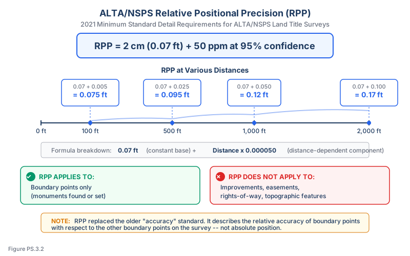
Relative Positional Precision = 2 cm (0.07 ft) + 50 ppm at 95% confidence level
Breaking this down:
- 2 cm (0.07 ft): The constant component -- a fixed error allowance regardless of distance
- 50 ppm: The proportional component -- 50 parts per million of the distance between any two points (equivalent to 0.05 ft per 1,000 ft)
- 95% confidence: Strictly, 95% confidence corresponds to 1.96 standard deviations (often rounded to "2 sigma" for convenience). In practice, the distinction between 1.96σ (95.0%) and 2σ (95.45%) is negligible for survey work
- Relative: The precision is between any two points on the survey, not relative to an external control network
What RPP Applies To:
RPP applies ONLY to the boundary of the surveyed property. Specifically, it applies to the relative position of any two boundary points on the survey, including monuments found or set.
What RPP Does NOT Apply To:
- Improvements (buildings, fences, walls)
- Easements shown on the survey
- Rights-of-way
- Topographic features
- Any feature other than boundary points
This distinction is heavily tested. A surveyor who achieves RPP on boundary points has met the standard even if improvements are located with lesser precision.
Example Calculation:
For two boundary corners 500 feet apart:
RPP = 0.07 ft + (500 ft x 50/1,000,000) = 0.07 + 0.025 = 0.095 ft
The relative position of those two corners must be known to within 0.095 feet at 95% confidence.
For two corners 1,000 feet apart:
RPP = 0.07 ft + (1,000 ft x 50/1,000,000) = 0.07 + 0.05 = 0.12 ft
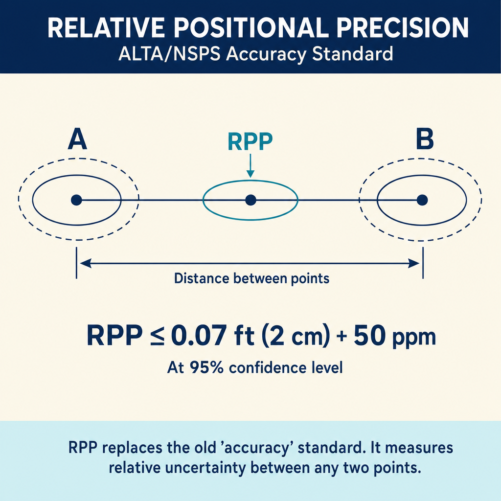
Common wrong path — applying RPP to improvements. The RPP specification (2 cm + 50 ppm) applies only to boundary points — corners, monuments, and the relative position of any two boundary features. It does not apply to buildings, fences, walls, utilities, topographic features, or anything else on the surveyed property. Exam questions test this by describing a scenario where an improvement (say, a building corner) is located with coarse precision but the boundary is to RPP standard, then asking whether the survey complies. It does. The surveyor is free to locate non-boundary features with whatever precision the scope requires — RPP is only the yardstick for boundary relationships. This is also why Table A Item 7(a) is written the way it is: when the client needs precise building dimensions, they request Item 7, not RPP.
Quick retrieval check — try before reading on.
▶An ALTA/NSPS survey shows two boundary corners 2,500 ft apart. What is the allowable RPP between them, and does it matter whether the surveyor measured from an external RTK base 3 miles away?
Allowable RPP = ft — about 2.3 inches at 95% confidence. And no, the 3-mile base distance does not matter for RPP, because RPP is relative — between the two boundary points, not between either point and an external control station. If the surveyor's RTK baseline produced a 0.3-ft absolute positioning error but the two corners are measured with 0.15-ft relative precision between them, the survey still complies with RPP. This is a frequent exam trap — candidates worry about absolute positioning when the standard only cares about the relative geometry of the boundary.
Minimum Standard Detail Requirements
Every ALTA/NSPS Land Title Survey must include, at minimum:
Boundary:
- All boundary lines with dimensions (bearings and distances)
- All corners, with description of monuments found or set
- Basis of bearings
- Closure precision (mathematical closure of the boundary)
- Gross land area
Title Elements:
- All easements, servitudes, and rights-of-way identified in the title commitment that are evidenced on the ground or in recorded plats/maps
- All encroachments, overlaps, and gaps along the boundary
- Evidence of possession or use inconsistent with the title (fences, walls, hedges)
Improvements:
- All buildings and other improvements on the surveyed property
- Measured distances from improvements to boundary lines (setback distances)
- Building footprints with dimensions where accessible
Access:
- Evidence of access to a public right-of-way
- The nature of the access (public road, private easement, etc.)
Utilities:
- Evidence of utilities serving the property (poles, manholes, meters, transformers)
- Underground utilities are shown only if evidence is visible or if Table A Item 11 is requested
Other Required Elements:
- Name and address of the surveyor
- Surveyor's certification
- Date of field work and date of plat preparation
- Scale (graphic and written)
- North arrow with basis of bearings
- Legend
Table A Optional Items
Table A contains optional items that the client must specifically request. The surveyor is not required to perform these unless requested. The 2021 standards include 19 categories of optional items (some with sub-items).
Key Table A items frequently referenced on the PS exam:
| Item | Description | Key Detail |
|---|---|---|
| 1 | Monuments placed | Monuments (or reference monument/witness) at all major corners of the surveyed boundary, unless already marked or referenced by existing monuments in close proximity |
| 2 | Address(es) | Address(es) of the surveyed property if disclosed in documents provided to the surveyor or observed during fieldwork |
| 3 | Flood zone classification | Depicted by scaled map location and graphic plotting only — based on federal FIRM or state/local equivalent |
| 4 | Gross land area | Plus other areas if specified by the client |
| 5 | Vertical relief | Source of information (ground survey, aerial map, etc.), contour interval, datum, originating benchmark when appropriate |
| 6(a)/(b) | Zoning | (a) full zoning classification, setbacks, height, FAR, parking — listed from a client-provided zoning report; (b) graphical depiction of setback requirements where no surveyor interpretation is required |
| 7(a)/(b)/(c) | Buildings | (a) exterior dimensions of all buildings at ground level; (b) square footage of footprints / other client-specified areas; (c) measured height above grade at a client-specified location |
| 8 | Substantial observed features | In addition to base-standard features (parking lots, billboards, signs, swimming pools, landscaping, refuse, etc.) |
| 9 | Parking spaces | Number and type of clearly identifiable spaces; striping of identifiable spaces in surface lots |
| 10 | Division/party walls | Relationship and location of division or party walls with respect to adjoining properties, as designated by the client |
| 11(a)/(b) | Underground utilities | Evidence determined by (a) plans/reports provided by client, or (b) markings coordinated by the surveyor via a private utility locate request — combined with observed evidence per §5.E.iv |
| 12 | Governmental agency survey requirements | E.g., HUD surveys, BLM lease surveys; client supplies the relevant requirements |
| 13 | Names of adjoining owners | Per current tax records ("et al." for multiple owners) |
| 14 | Distance to nearest intersecting street | As specified by the client |
| 15 | Rectified orthophotography / remote sensing | Photogrammetric, LiDAR, mobile-scan products as basis for showing non-boundary features when ground measurement is not necessary; surveyor must discuss ramifications and note source/date/precision on plat |
| 16 | Evidence of recent earth moving / construction | Observed during fieldwork |
| 17 | Proposed changes in street ROW | If made available by the controlling jurisdiction; plus evidence of recent street/sidewalk construction |
| 18 | Plottable offsite (appurtenant) easements | Disclosed in documents provided to or obtained by the surveyor |
| 19 | Professional liability insurance | Client-specified minimum amount; certificate furnished on request; not addressed on the plat |
| 20 | Negotiated additional items | 20(a), 20(b), etc. — engineering design surveys go here, not Items 5/11 |
Important Notes on Table A:
- The client requests the items, not the surveyor
- If a Table A item is not requested, the surveyor has no obligation to investigate or show that information
- Some items require the client to provide documents (e.g., zoning reports, utility records, proposed improvement plans)
- The surveyor should confirm Table A selections in writing before beginning work
Zoning
The 2021 standards address zoning as follows:
- If the client provides a zoning report or zoning letter from the local authority, the surveyor graphically depicts the zoning classification and building setback lines on the survey
- The surveyor is not required to interpret zoning regulations
- If no zoning report is provided and Table A Item 6(a) is not requested, the surveyor has no zoning obligation
- The surveyor does not opine on zoning compliance
Certification
The surveyor must include a certification on the plat. The certification is addressed to specific parties -- typically the buyer, lender, and title company -- as identified by the client. Key elements of the certification:
- Statement that the survey was prepared in accordance with the 2021 ALTA/NSPS standards
- Identification of Table A items included
- Reference to the title commitment used
- Effective date
- Surveyor's signature, seal, and license number
The certification language cannot be modified to reduce the surveyor's obligations under the standards. The surveyor certifies to the parties named -- the survey cannot be relied upon by unnamed parties.
Underground Utilities and Limitations
The standards are explicit about underground utility limitations:
- The surveyor shows evidence of underground utilities observed during the survey (manholes, cleanouts, valve boxes)
- If Table A Item 11 is requested, the surveyor plots information obtained from utility company records
- The surveyor does NOT guarantee the completeness or accuracy of underground utility information
- A note must appear on the survey stating that underground utilities are shown from available records and observed evidence only
Exam Tips
- The RPP formula (2 cm + 50 ppm at 95% confidence) applies ONLY to boundary points -- this is the single most tested fact about ALTA/NSPS standards
- The client must request the ALTA/NSPS survey and specify Table A items -- the surveyor cannot decide to do one unilaterally
- Table A items are optional until requested; once requested, they are mandatory
- 95% confidence ≈ 1.96 sigma (often approximated as 2 sigma) -- if the exam gives you a 1-sigma value, multiply by 1.96 (or 2.0 for quick estimation)
- Underground utilities are never guaranteed, even with Table A Item 11
- The surveyor shows zoning graphically only if a zoning report is provided -- no interpretation required
- The 2021 standards are the current version -- do not confuse with the 2016 or earlier versions
- The certification is addressed to specific named parties -- unnamed parties cannot rely on the survey
- Remember that RPP applies to monuments found OR set -- it is the relative precision between boundary points, not just set monuments
Related Test Topics
- State boundary survey statutes (Topic 3.3)
- FEMA flood zone determination and Table A Item 3 (Topic 3.4)
- Professional liability and standard of care (Module 2)
- Evidence evaluation for boundary determination (Module 1)
- Easement identification and depiction (Module 1, Topic 1.6)
Further Reading
Authoritative sources for deeper study
2021 ALTA/NSPS Land Title Survey Standards — Current minimum standard detail requirements for ALTA/NSPS land title surveys.
Brown's Boundary Control and Legal Principles (7th Ed., Robillard & Wilson) — Standard textbook on boundary law, evidence hierarchy, and retracement.
Wattles, Writing Legal Descriptions (1976) — Gold-standard reference on metes-and-bounds, sectional, and combination descriptions.
Last updated: 2026-04-17