FS Exam Preparation
Comprehensive preparation for the Fundamentals of Surveying (FS) exam. 7 modules covering all 7 exam domains with 60 in-depth topics.
Module 1: Surveying Processes & Methods
Module 2: Mapping Processes & Methods
Module 3: Boundary Law & Real Property
Module 4: Surveying Principles & Geodesy
Module 5: Survey Computations
Module 6: Business Concepts
Water Boundaries & Riparian Law
Learning Objectives
After completing this topic, you should be able to:
- Distinguish between riparian and littoral rights
- Define accretion, erosion, reliction, and avulsion
- Explain the difference between navigable and non-navigable waters
- Understand how water boundaries shift with natural processes
- Describe the concept of the ordinary high-water mark
- Identify the ownership implications of different water boundary changes
Overview
Water boundaries present unique legal and practical challenges for surveyors. Unlike fixed land boundaries, water boundaries can move over time as natural processes change the position of shorelines and riverbanks. The doctrines governing water boundaries -- including riparian rights, littoral rights, accretion, erosion, and avulsion -- determine how these changes affect property ownership.
The FS exam tests fundamental concepts of water boundary law, and the PS exam goes into much greater depth.
Key Concepts
Riparian vs. Littoral Rights
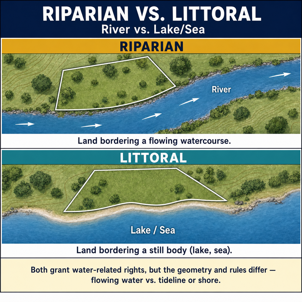
Riparian rights apply to properties that border flowing water (streams and rivers):
- The property owner has the right to reasonable use of the water
- Ownership extends to the thread of the stream (the line equidistant from the two banks; some jurisdictions instead use the thalweg or deepest part of the channel) for non-navigable waters
- For navigable waters, ownership typically extends to the ordinary high-water mark (public owns the bed)
Littoral rights apply to properties that border standing water (lakes and oceans):
- The property owner has the right of access to the water
- Ownership extends to the ordinary high-water mark for navigable lakes
- For non-navigable lakes, ownership may extend to the center of the lake (varies by jurisdiction)
Navigability
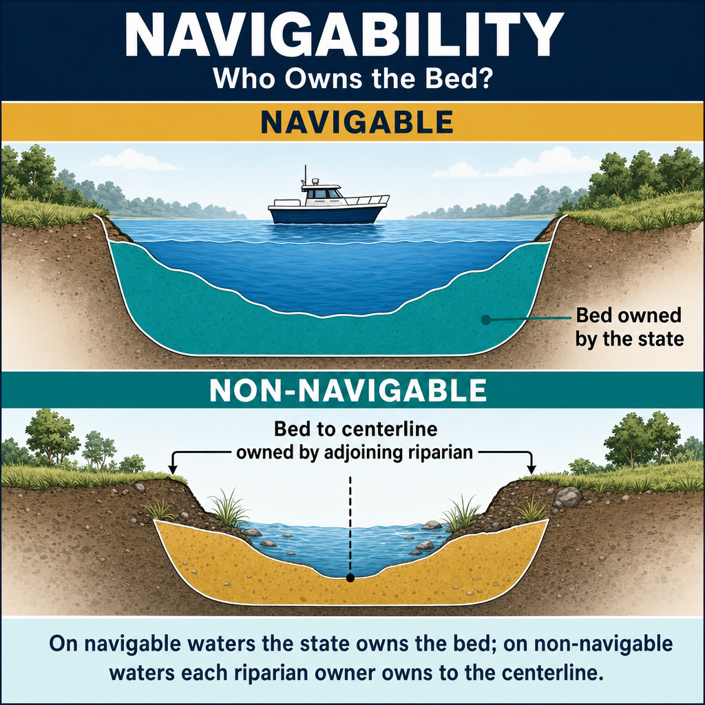
The navigability of a body of water determines who owns the bed:
Navigable waters:
- The bed is owned by the state (in trust for the public)
- Private ownership extends only to the ordinary high-water mark
- The federal test for navigability: the water body was used, or was susceptible to being used, for commerce and transportation at the time of statehood (The Daniel Ball, 77 U.S. (10 Wall.) 557 (1871); PPL Montana, LLC v. Montana, 565 U.S. 576 (2012))
Non-navigable waters:
- The bed is typically owned by the adjacent private landowners
- For streams, ownership extends to the thread of the stream (centerline)
- For small lakes, ownership may extend to the center (varies by state)
Natural Processes Affecting Water Boundaries
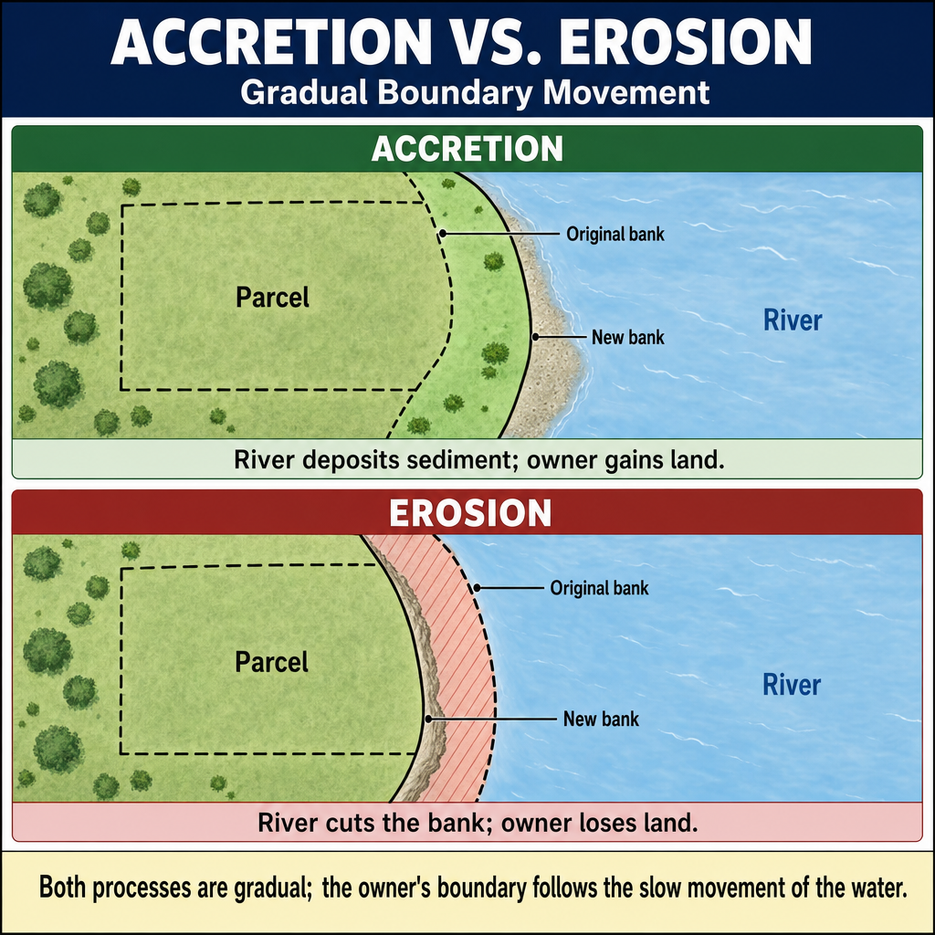
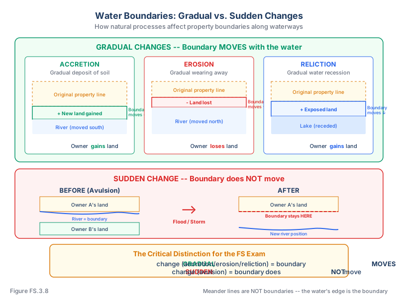
Accretion:
- The gradual and imperceptible addition of land by the deposit of soil (sediment) along a waterway
- The new land belongs to the riparian owner -- the boundary moves with the water
- Must be natural (not caused by artificial structures)
Erosion:
- The gradual and imperceptible wearing away of land by water action
- The boundary moves with the water -- the riparian owner loses land
- The counterpart of accretion
Reliction (dereliction):
- The exposure of land by the gradual and permanent recession of water
- The newly exposed land belongs to the riparian owner
- The water must recede naturally and permanently (not temporarily due to drought)
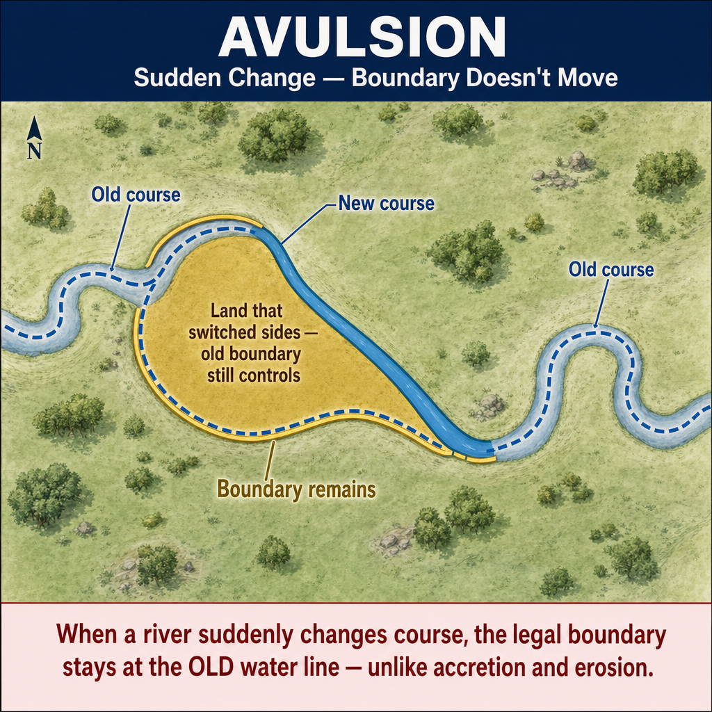
Avulsion:
- A sudden and perceptible change in the course of a waterway (flood, earthquake, storm)
- The boundary does NOT change -- it remains where it was before the avulsion
- The affected landowner retains title to the land on the original side of the boundary
- The key distinction: gradual changes move the boundary; sudden changes do not
Summary Table
| Process | Speed | Effect on Boundary | Ownership Change |
|---|---|---|---|
| Accretion | Gradual | Boundary moves with water | Riparian owner gains land |
| Erosion | Gradual | Boundary moves with water | Riparian owner loses land |
| Reliction | Gradual | Boundary moves with water | Riparian owner gains land |
| Avulsion | Sudden | Boundary does NOT move | No change in ownership |
Ordinary High-Water Mark (OHWM)
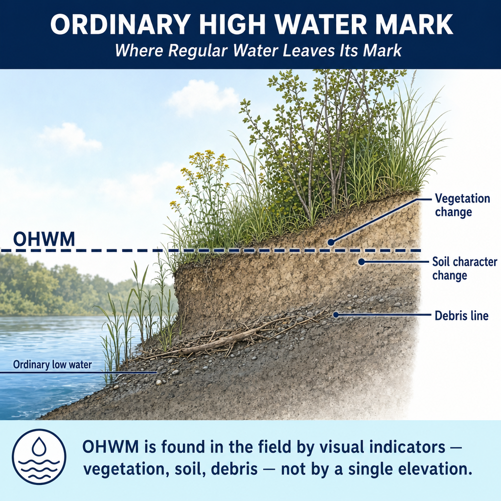
The ordinary high-water mark is the line on the bank where the water's action is so common and usual as to mark a distinct character on the soil, vegetation, or debris (paraphrasing the classic articulation in Howard v. Ingersoll, 54 U.S. (13 How.) 381 (1851)).
Indicators of OHWM:
- Change in vegetation (from aquatic to terrestrial species)
- Erosion marks and scouring on the bank
- Debris line (drift line) from typical high water
- Change in soil character (water-stained vs. dry)
- Presence of litter or wrack line
Significance:
- Defines the boundary between private and public land on navigable waters
- Determines the extent of riparian and littoral rights
- May define regulatory jurisdiction (wetlands, waterway permits)
Meander Lines
In the PLSS, meander lines are run along the banks of navigable waterways and lakes at the time of the original survey.
Critical rule: As a general rule, meander lines are not boundary lines (Brown's §9.8 Principle 8: "In most instances, meander lines do not control boundaries, but they do control area determination."). They are approximate surveys of the water's edge used for calculating the area of adjacent lots. The actual boundary is the water's edge (ordinary high-water mark), not the meander line. Narrow exceptions exist where the current water boundary cannot be located, or where the discrepancy between the meander line and the shoreline indicates intentional omission of certain lands or fraud — in those cases the meander line may be accepted as the boundary.
If accretion or reliction occurs, the boundary (at the water) moves with the water, but the meander line (shown on the original plat) does not change. The riparian owner's land grows or shrinks accordingly.
Common wrong path — treating the meander line as the boundary. Meander lines look like the boundary on the plat: they are drawn along the water, they have bearings and distances, and they are surveyed monuments of record. But they are generally not boundaries. The actual boundary is the water itself — the ordinary high-water mark on navigable bodies, or the thread of the stream on non-navigable ones. When accretion adds 200 ft of new land between the old meander line and the current shoreline, that 200 ft belongs to the riparian owner, not to the state or to some interior owner. Exam questions test this by describing a gradual accretion and asking "where is the property boundary now" — the answer is always the current water's edge (not the original meander line, not a line split between them, and not the original high-water location).
Quick retrieval check — try before reading on.
▶A 1905 PLSS plat shows a meander line along the west bank of the Missouri River. Since 1905, gradual accretion has deposited 180 ft of new shoreline west of the old meander line — the riverbank now sits 180 ft west of where the 1905 survey shows it. Who owns the new 180-ft strip, and what happens if instead the river had jumped its channel in a single 1927 flood?
Gradual accretion (given): The riparian owner gains the 180-ft strip. The boundary moves with the water; the meander line was never the legal boundary, only an approximation for area calculation in the original PLSS survey. Today's boundary is the current shoreline at the ordinary high-water mark, not the 1905 meander line.
Avulsion (alternative 1927 flood): The boundary stays where it was before the avulsion — likely at or near the 1905 meander line, subject to evidence of where the water ran between 1905 and 1927. The riparian owner does NOT gain the 180 ft, and any land on the "wrong" side of the new channel still belongs to its pre-avulsion owner. The key fact distinguishing these outcomes is gradual vs. sudden — not the amount of land involved. A 180-ft gain over 120 years is gradual; a 180-ft jump in a week is avulsion.
Exam Tips
- Gradual changes (accretion, erosion, reliction) move the boundary; sudden changes (avulsion) do not
- Accretion adds land to the riparian owner; erosion takes it away; reliction exposes new land
- Riparian = flowing water (rivers, streams); littoral = standing water (lakes, oceans)
- For navigable waters, the state owns the bed; private ownership extends to the OHWM
- For non-navigable streams, private ownership extends to the thread of the stream (center)
- Meander lines are generally NOT boundaries -- the water's edge is the boundary in most cases (narrow exceptions: water boundary cannot be located, or large discrepancy indicates fraud/intentional omission)
- The key test for avulsion vs. accretion is whether the change was sudden or gradual
- The FS exam may present a scenario describing a water change and ask whether the boundary moved
- Know the indicators of the ordinary high-water mark (vegetation change, erosion marks, debris line)
Related Test Topics
- Controlling Elements and Evidence (Topic 3.2)
- PLSS Fundamentals (Topic 3.7)
- Unwritten Rights and Adverse Possession (Topic 3.3)
- Cadastral and Boundary Surveys (Module 1, Topic 1.6)
Further Reading
Authoritative sources for deeper study
Shalowitz & Reed, Shore and Sea Boundaries (Vols. 1–3, NOAA) — Definitive U.S. reference on water-boundary law and tidal datums.
Brown's Boundary Control and Legal Principles (7th Ed., Robillard & Wilson) — Standard textbook on boundary law, evidence hierarchy, and retracement.
Clark, A Treatise on the Law of Surveying and Boundaries — Long-standing legal reference on boundary disputes and surveyor liability.
Last updated: 2026-04-17