FS Exam Preparation
Comprehensive preparation for the Fundamentals of Surveying (FS) exam. 7 modules covering all 7 exam domains with 60 in-depth topics.
Module 1: Surveying Processes & Methods
Module 2: Mapping Processes & Methods
Module 3: Boundary Law & Real Property
Module 4: Surveying Principles & Geodesy
Module 5: Survey Computations
Module 6: Business Concepts
Coordinate Transformations
Learning Objectives
After completing this topic, you should be able to:
- Explain the purpose of coordinate transformations
- Describe the parameters of a conformal (4-parameter) transformation
- Describe the parameters of an affine (6-parameter) transformation
- Understand the Helmert (7-parameter) transformation for 3D conversions
- Calculate a simple 2D rotation and translation
- Identify when each transformation type is appropriate
Overview
Coordinate transformations convert coordinates from one system to another. In surveying, transformations are needed whenever data from different sources must be combined: converting local coordinates to state plane, aligning old survey data to new control, transforming between datums, or integrating GNSS data with total station observations.
The FS exam tests your understanding of the basic transformation types and their parameters, with emphasis on 2D conformal transformations.
Key Concepts
Why Transformations Are Needed
Common situations requiring coordinate transformations:
- Localizing GNSS data: Converting WGS 84 coordinates to a local grid or state plane system
- Integrating old and new surveys: Aligning data collected on different coordinate systems or at different epochs
- Datum conversions: Transforming coordinates between NAD 27 and NAD 83, or between WGS 84 and local datums
- CAD alignment: Fitting a design drawing to survey control
- Ground-to-grid conversion: Converting measured ground coordinates to grid (state plane) coordinates
Types of 2D Transformations
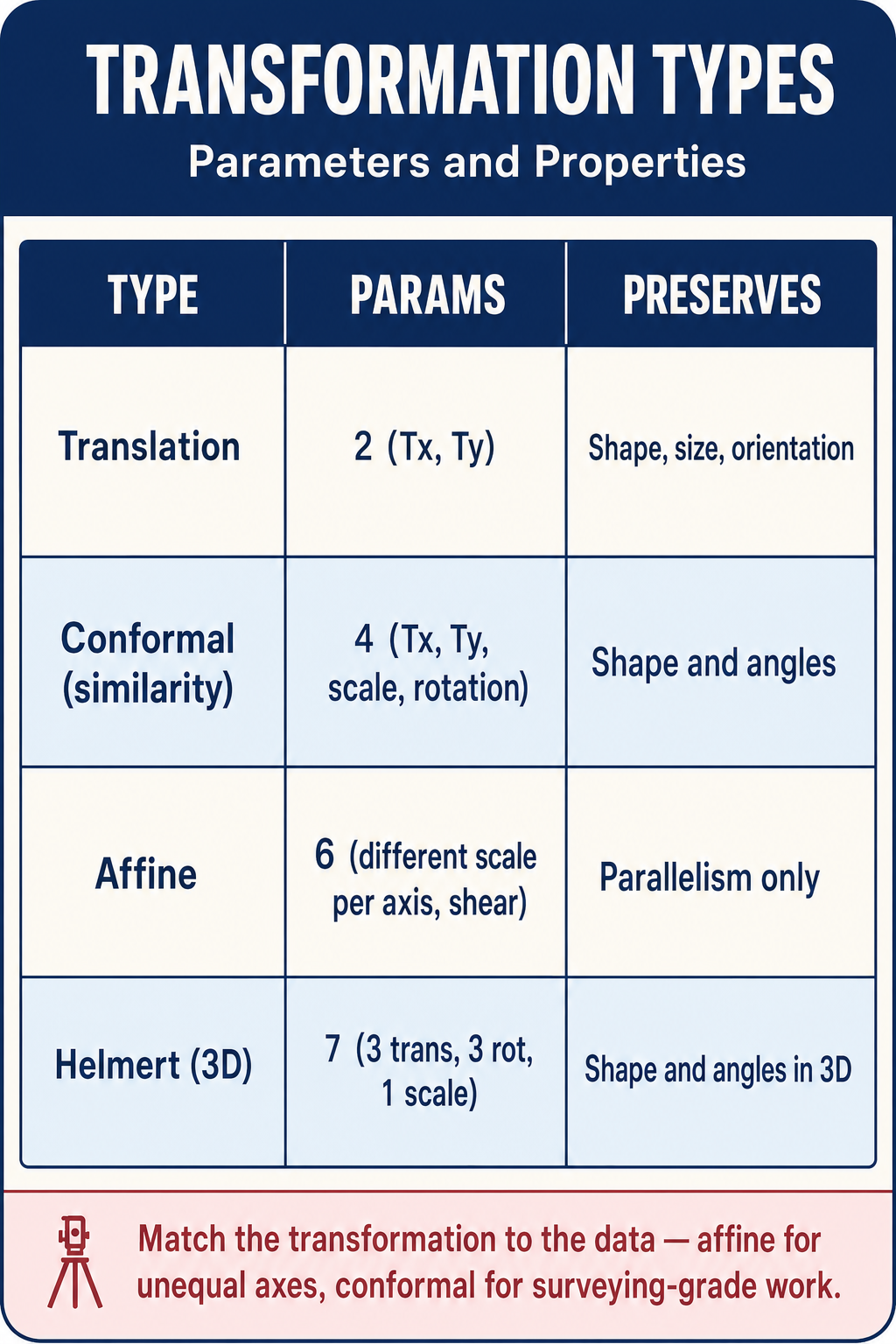
Translation (2 parameters):
- Shifts all coordinates by a constant amount in X and Y
- Parameters: delta-X (shift in X) and delta-Y (shift in Y)
- Does not change orientation or scale
Rotation (1 parameter):
- Rotates all coordinates about a specified origin by a fixed angle
- Parameter: rotation angle (theta)
Scale (1 parameter):
- Multiplies all coordinates by a constant factor
- Parameter: scale factor (s)
- Changes distances but preserves angles
Conformal Transformation (4-Parameter)
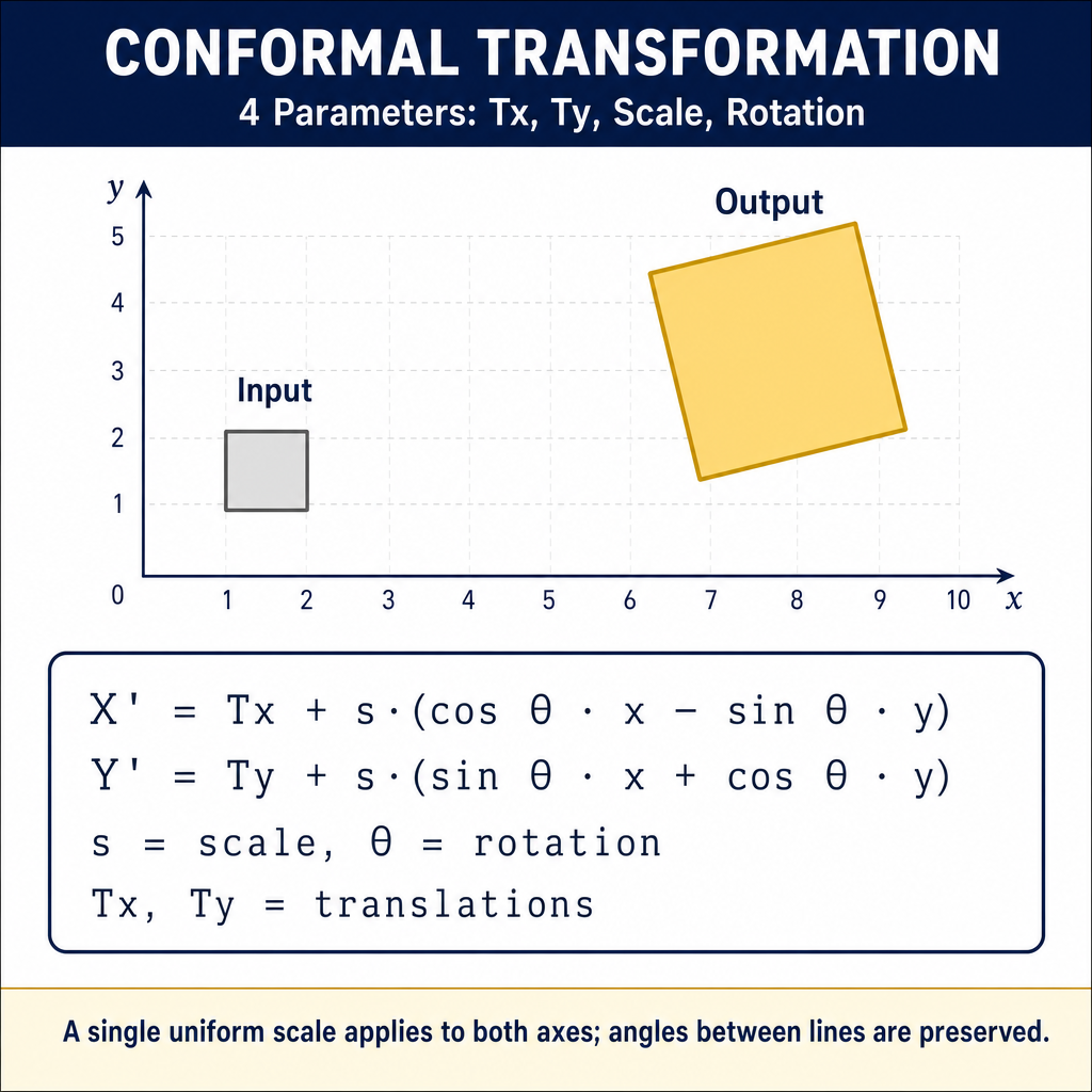
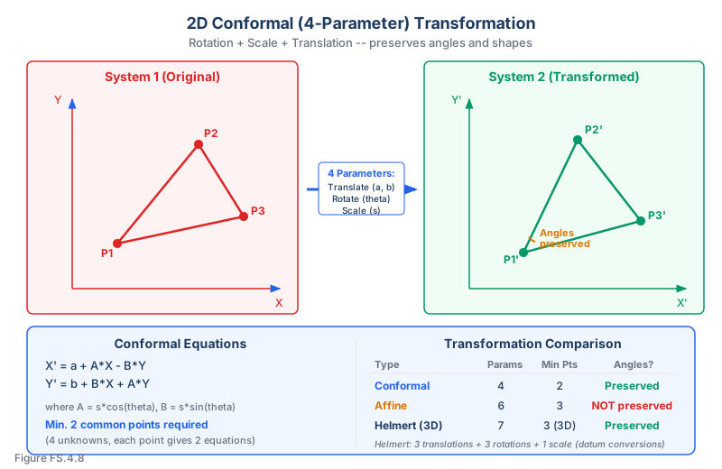
The 2D conformal (Helmert) transformation combines rotation, scale, and translation. It preserves angles and shapes while allowing changes in position, orientation, and size.
Four parameters:
- Translation in X (a)
- Translation in Y (b)
- Rotation angle (theta)
- Scale factor (s)
Equations:
Or, using combined parameters (where A = s cos theta and B = s sin theta):
Requirements: A minimum of 2 common points (known in both systems) to solve for the 4 parameters. Additional points provide redundancy and allow quality assessment.
When to use: When the data was collected with good internal consistency (low random errors) and the distortion between systems can be described by rotation, scale, and translation alone. This is the most common transformation in surveying.
Affine Transformation (6-Parameter)
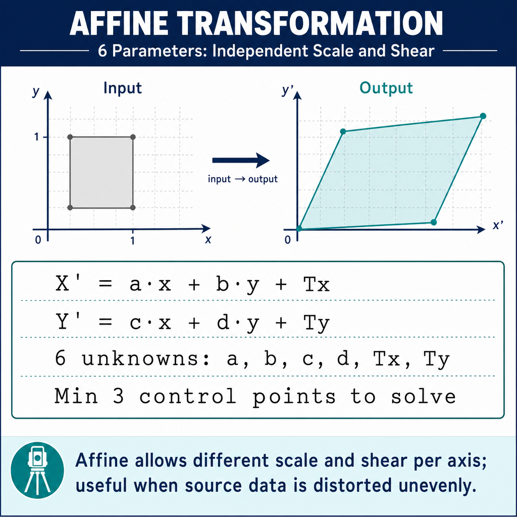
The affine transformation allows for different scale factors in the X and Y directions, as well as non-perpendicularity (skew) between axes. It is more flexible than the conformal transformation.
Six parameters:
- Translation in X
- Translation in Y
- Rotation angle
- Scale in X direction
- Scale in Y direction
- Skew (non-orthogonality)
Equations:
Requirements: A minimum of 3 common points to solve for the 6 parameters.
When to use: When there is differential scaling (distortion that differs in X and Y directions), such as when digitizing from a paper map that has shrunk or stretched unevenly, or when combining data from systems with different projection distortions.
Limitation: The affine transformation does not preserve angles (it is not conformal). This means bearings computed in the original system may differ from bearings in the transformed system.
Helmert Transformation (7-Parameter, 3D)
The 3D Helmert transformation (also called the 7-parameter similarity transformation) is used for converting between three-dimensional coordinate systems (e.g., datum transformations).
Seven parameters:
- Translation in X
- Translation in Y
- Translation in Z
- Rotation about X axis
- Rotation about Y axis
- Rotation about Z axis
- Scale factor
Equations (simplified):
Where T is the translation vector, s is the scale factor, and R is the rotation matrix.
When to use: Converting between geodetic datums (NAD 83 to WGS 84, or between ITRF realizations). The rotations are typically very small (arc seconds) and the scale factor is close to 1.
Convention note: The form above is the Bursa–Wolf (position-vector) convention used by NGS/NOAA — rotations applied to the position vector relative to the geocentric origin. A second convention, Molodensky–Badekas, places the rotations about a centroid of the network rather than the geocenter. Published NGS/NOAA transformation parameters between WGS 84 and ITRF realizations are Bursa–Wolf; verify the convention before applying parameters from other agencies.
Requirements: A minimum of 3 common points (in 3D) to solve for 7 parameters.
Residual Analysis
When more common points are used than the minimum required, the transformation produces residuals -- the differences between the transformed coordinates and the known coordinates at each control point.
Residual analysis reveals:
- The overall quality of the transformation (RMSE -- Root Mean Square Error)
- Individual points that may have errors (outliers/blunders)
- Whether the transformation model is appropriate for the data
- Systematic patterns that may indicate a model mismatch
Example: A 4-parameter conformal transformation is computed using 5 common points. The residuals (in meters) are:
| Point | Residual N | Residual E |
|---|---|---|
| 1 | +0.012 | -0.008 |
| 2 | -0.015 | +0.011 |
| 3 | +0.008 | +0.006 |
| 4 | -0.010 | -0.013 |
| 5 | +0.005 | +0.004 |
These residuals are small and show no systematic pattern, indicating a good fit.
Practical Application: GNSS Site Calibration
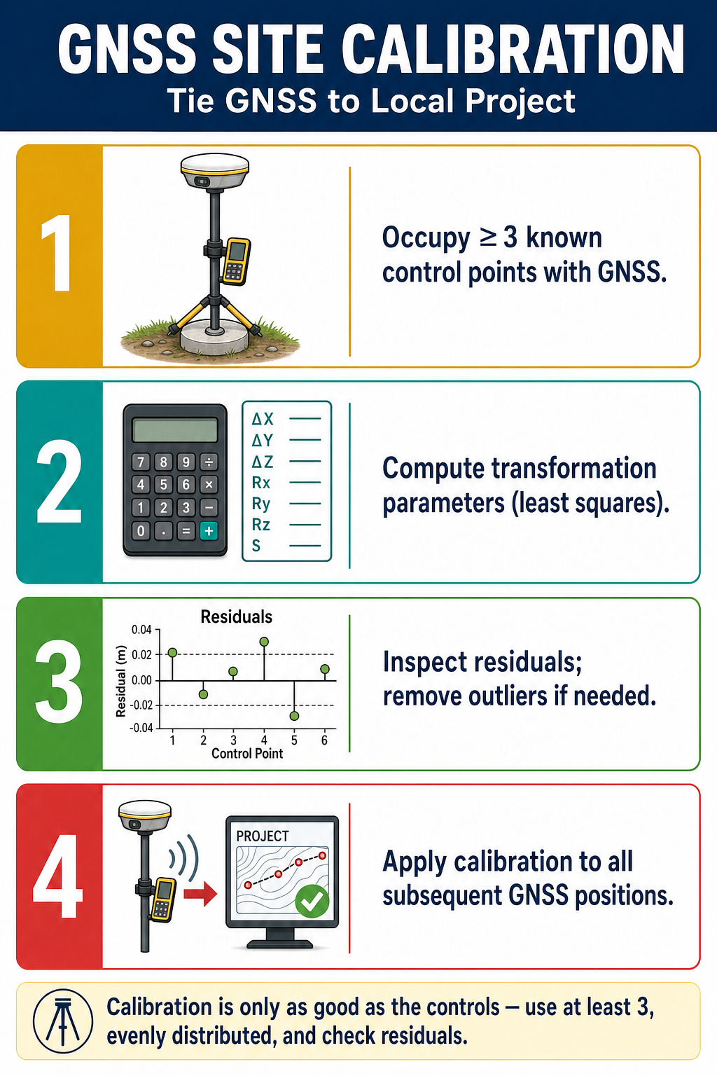
When using RTK GNSS for construction or local surveys, a site calibration (localization) is performed:
- Observe several control points with GNSS (getting WGS 84 / NAD 83 coordinates)
- Enter the known local coordinates for these same points
- The system computes a transformation (typically conformal) between the GNSS coordinates and the local system
- All subsequent GNSS observations are transformed to local coordinates in real time
- Residuals at the control points indicate the quality of the calibration
Best practice: Use at least 4 well-distributed control points; check residuals and reject any point with an anomalous residual.
Common wrong path — using affine to "fix" a conformal problem. When a 4-parameter conformal transformation produces residuals that are too large, it's tempting to switch to a 6-parameter affine transformation and watch the residuals shrink. The affine model will always fit better because it has two extra degrees of freedom — but the "better fit" may be masking a real problem (blunders in control, datum mismatch, or incorrect common-point identification) rather than correcting it. Affine transformations don't preserve angles — bearings in the transformed system will differ from bearings in the original. For boundary work and any application where angular relationships matter, conformal is the correct model; a better fit from affine is a red flag, not a success. Exam questions plant this trap by asking which transformation to use when residuals are "unacceptably large" — the correct answer is to investigate the residuals (identify outliers, verify common points, consider datum differences), not to switch to a more permissive model.
Quick retrieval check — try before reading on.
▶A GNSS site calibration uses 6 control points and a 4-parameter conformal transformation. Five points have residuals under 0.02 m; one point has a residual of 0.15 m. Switching to a 6-parameter affine transformation reduces all residuals to under 0.03 m. Which transformation should you use for the project?
Conformal — but first investigate the outlier. The anomalous 0.15 m residual on one point is a sign that something is wrong with that point: it may have been identified incorrectly, disturbed since the published coordinate was established, or had a measurement blunder in the GNSS observation. The right action is to investigate that specific point — check its identity, re-observe it, compare to other published values — and likely exclude it from the calibration. A conformal transformation with the outlier excluded should produce acceptable residuals across the remaining 5 points. Switching to affine "works" mathematically but hides the real problem, and introduces angular distortion that will cause downstream errors on any angular measurement in the project area. The affine's improvement is a symptom of the outlier, not a correct model — don't chase the smaller RMSE at the cost of adding a more permissive model with angle distortion.
Exam Tips
- A conformal (4-parameter) transformation preserves angles and requires a minimum of 2 common points
- An affine (6-parameter) transformation allows differential scaling and requires 3 common points
- A 7-parameter Helmert transformation is used for 3D datum conversions and requires 3 common 3D points
- The conformal transformation is the most commonly used in surveying -- know its equations
- Residuals measure the quality of fit; large residuals at a specific point may indicate a blunder at that point
- Conformal transformations preserve angles; affine transformations do not
- More control points than the minimum required provide redundancy and allow error detection
- Site calibration (localization) is a conformal transformation applied to align GNSS data with local control
- The FS exam may ask you to identify the parameters, compute a simple transformation, or determine the minimum number of control points
- Remember: rotation changes direction, scale changes size, translation changes position
Related Test Topics
- Horizontal Surveys and Methods (Topic 4.1)
- State Plane Coordinates (Topic 4.6)
- Datums and Conversions (Topic 4.5)
- GNSS/GPS Methods (Module 1, Topic 1.3)
Further Reading
Authoritative sources for deeper study
NOAA Manual NOS NGS 5 — State Plane Coordinate System of 1983 — Definitive NGS reference for SPCS83 zone constants, projections, and conversions.
Snyder, USGS Bulletin 1532 — Map Projections Used by the USGS — Mathematical treatment of common map projections (Lambert Conformal Conic, Transverse Mercator, etc.).
Wolf & Ghilani, Elementary Surveying — Chapter on map projections and the State Plane Coordinate System.
NGS Geodetic Glossary (1986, NOAA repository) — Authoritative definitions for geodetic, GNSS, and surveying terms.
Last updated: 2026-04-17