FS Exam Preparation
Comprehensive preparation for the Fundamentals of Surveying (FS) exam. 7 modules covering all 7 exam domains with 60 in-depth topics.
Module 1: Surveying Processes & Methods
Module 2: Mapping Processes & Methods
Module 3: Boundary Law & Real Property
Module 4: Surveying Principles & Geodesy
Module 5: Survey Computations
Module 6: Business Concepts
Datums & Datum Conversions
Learning Objectives
After completing this topic, you should be able to:
- Define a geodetic datum and its components
- Describe the major horizontal datums (NAD 27, NAD 83, WGS 84)
- Describe the major vertical datums (NGVD 29, NAVD 88)
- Explain why datum transformations are necessary
- Understand the difference between geocentric and local datums
- Describe the upcoming NSRS modernization (NATRF2022, NAPGD2022)
Overview
A datum is a reference system that defines the position of the coordinate origin, the orientation of the coordinate axes, and the shape and size of the reference surface (ellipsoid for horizontal datums, geoid for vertical datums). Every coordinate or elevation in surveying is referenced to a specific datum, and mixing datums without proper transformation is one of the most common sources of error in geospatial data.
The FS exam tests your understanding of the major datums used in the United States and the basic concepts of datum transformation.
Key Concepts
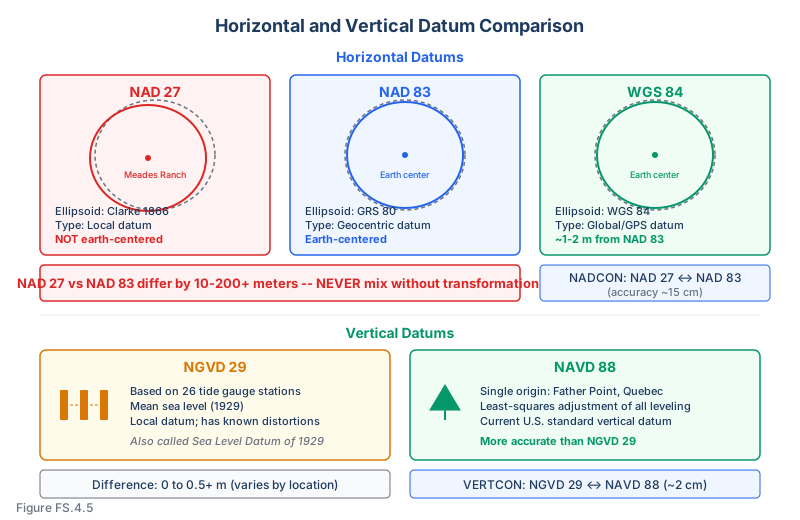
What Is a Datum?
A horizontal datum defines a reference for latitude and longitude (and horizontal coordinates):
- The ellipsoid (shape and size)
- The orientation and position of the ellipsoid relative to the earth
- The network of control points with published coordinates
A vertical datum defines a reference for elevations:
- A specific level surface (approximating mean sea level)
- The network of benchmarks with published elevations
Major Horizontal Datums
NAD 27 (North American Datum of 1927):
- Based on the Clarke 1866 ellipsoid
- Origin point: Meades Ranch, Kansas (the ellipsoid was positioned to best fit North America at this point)
- A local datum (not earth-centered)
- Coordinates were determined by classical triangulation and traverse
- Still found on many older maps, plats, and deeds
- The ellipsoid does not fit well away from the origin; distortions accumulate over large distances
NAD 83 (North American Datum of 1983):
- Based on the GRS 80 ellipsoid
- Earth-centered (geocentric) datum
- Determined by satellite (Doppler) observations and classical surveys
- The current standard horizontal datum in the United States
- Multiple realizations (adjustments): NAD 83 (1986), NAD 83 (HARN), NAD 83 (CORS96), NAD 83 (2011)
- Each realization improves the accuracy; coordinates may differ by centimeters between realizations
WGS 84 (World Geodetic System 1984):
- The GPS reference datum
- Based on the WGS 84 ellipsoid (virtually identical to GRS 80)
- Earth-centered, global datum
- Maintained by the U.S. Department of Defense
- Practically coincident with NAD 83 at the 1-2 meter level, but differs at the centimeter level
- WGS 84 is periodically refined to align with ITRF (the most accurate global reference frame)
Differences Between NAD 27 and NAD 83
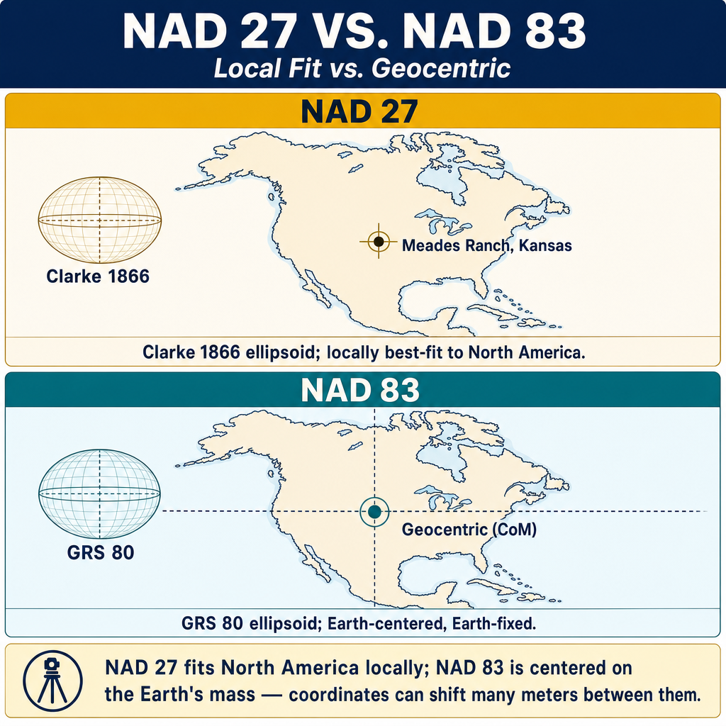
The coordinate differences between NAD 27 and NAD 83 for the same physical point can be significant:
| Parameter | Typical Difference (Conterminous U.S.) |
|---|---|
| Latitude | 0 to 2 arc seconds (0 to 60 meters) |
| Longitude | 0 to 3 arc seconds (0 to 100 meters) |
| Northing (State Plane) | 0 to 200+ meters |
| Easting (State Plane) | 0 to 200+ meters |
These are not small differences. Using NAD 27 coordinates in a NAD 83 system (or vice versa) without transformation produces significant errors.
Common wrong path — treating a NAD 83 "realization" like a datum change. NAD 83 has been adjusted several times: NAD 83(1986), NAD 83(HARN), NAD 83(CORS96), NAD 83(2011), and so on. These are realizations of the same datum, not different datums. The coordinate of a physical monument can differ by several centimeters — occasionally more than a decimeter — between realizations, which is much smaller than the 30+ meters separating NAD 27 from NAD 83, but much larger than the centimeter-level precision expected of modern GNSS control. Students sometimes answer "use NADCON" when the question is really about realization differences within NAD 83. NADCON converts between NAD 27 and NAD 83; realization differences within NAD 83 require a specific realization-to-realization transformation (e.g., HTDP from NGS, or epoch-shift via CORS). Exam questions plant this trap by quoting coordinates with realization tags — read them carefully.
Quick retrieval check — try before reading on.
▶A survey from 2008 reports coordinates on "NAD 83 (HARN)." A current survey reports coordinates on "NAD 83 (2011) epoch 2010.00." Can you directly compare the two coordinate sets for a physical monument that hasn't moved? If not, what tool applies?
No — not directly. Although both are NAD 83, the realizations differ. For a typical CONUS location, NAD 83(HARN) and NAD 83(2011) coordinates for the same monument can differ by centimeters to a decimeter. To compare the two, apply a realization-to-realization transformation. NGS's HTDP (Horizontal Time-Dependent Positioning) tool handles this: input the older realization and epoch, specify the target realization and epoch, and it outputs the adjusted coordinates. NADCON is not the right tool here — NADCON bridges NAD 27 and NAD 83, not realizations within NAD 83. If the monument has moved (tectonic motion, subsidence), even HTDP may not suffice; you'd need observations at both epochs and a model of the physical movement. On the exam, the keyword is "realization" — treat it as a subtle but real shift, not the same as the datum label.
Major Vertical Datums
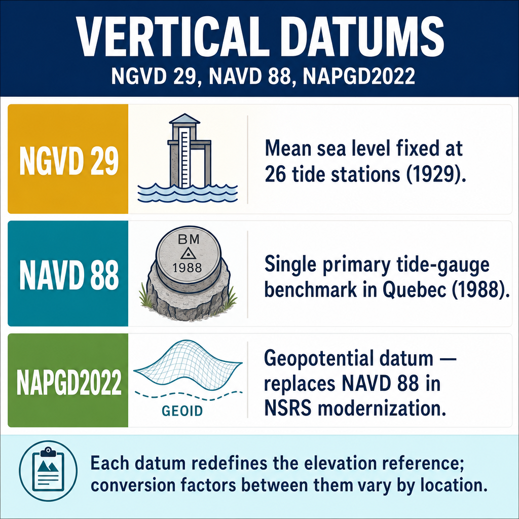
NGVD 29 (National Geodetic Vertical Datum of 1929):
- Based on mean sea level as determined at 26 tide gauge stations in North America
- Also called the Sea Level Datum of 1929
- The vertical reference for older maps, plats, and surveys
- Has known distortions because the geoid and mean sea level do not coincide perfectly
NAVD 88 (North American Vertical Datum of 1988):
- Determined by a least-squares adjustment of all leveling data in North America, then held fixed to a single tidal benchmark at Father Point/Rimouski, Quebec (rather than to the mean of 26 tidal gauges as in NGVD 29)
- The current standard vertical datum in the United States
- More accurate and internally consistent than NGVD 29
Differences between NGVD 29 and NAVD 88:
- Typically 0 to 0.5 meters across the conterminous U.S., but can be larger in some areas (NGS VERTCON documentation; Zilkoski, Results of the General Adjustment of NAVD 88, 1992)
- The difference varies by location (not a constant offset)
- Conversion requires using published datum shifts (VERTCON tool from NGS)
Datum Transformations
Horizontal transformation (NAD 27 to NAD 83):
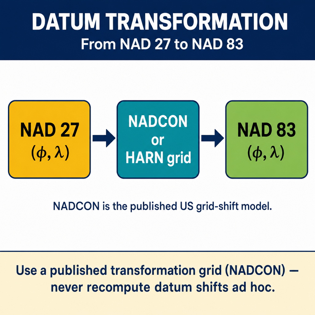
- Uses NADCON (North American Datum Conversion) from NGS
- Based on a grid of latitude and longitude shifts
- Accuracy: approximately 15 cm (NGS NADCON documentation, geodesy.noaa.gov)
Vertical transformation (NGVD 29 to NAVD 88):
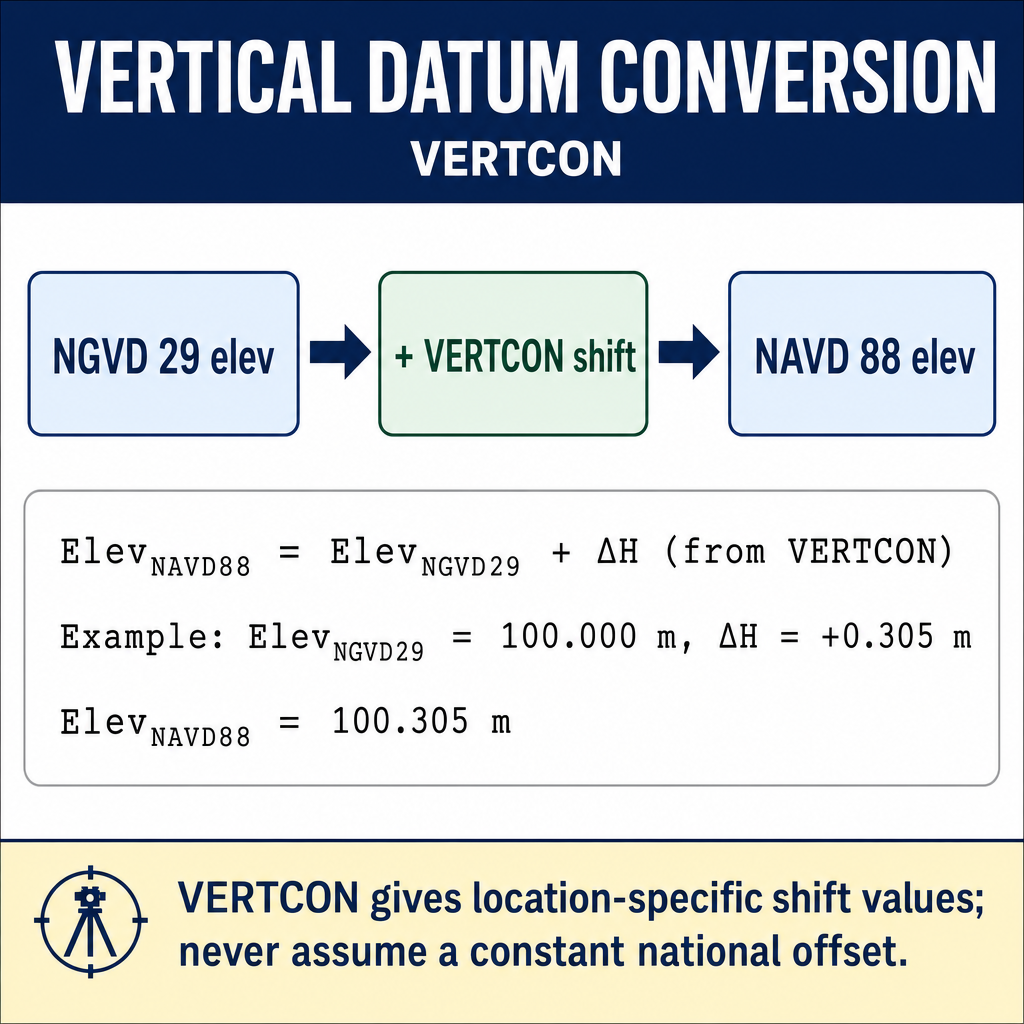
- Uses VERTCON from NGS
- Based on a grid of elevation differences
- Accuracy: approximately 2 cm (NGS VERTCON documentation, geodesy.noaa.gov)
General 3D transformations (between global frames):
- Seven-parameter (Helmert) transformation: 3 translations, 3 rotations, 1 scale factor
- Used to convert between WGS 84, NAD 83, ITRF
- The parameters are published by NGS and other agencies
NSRS Modernization
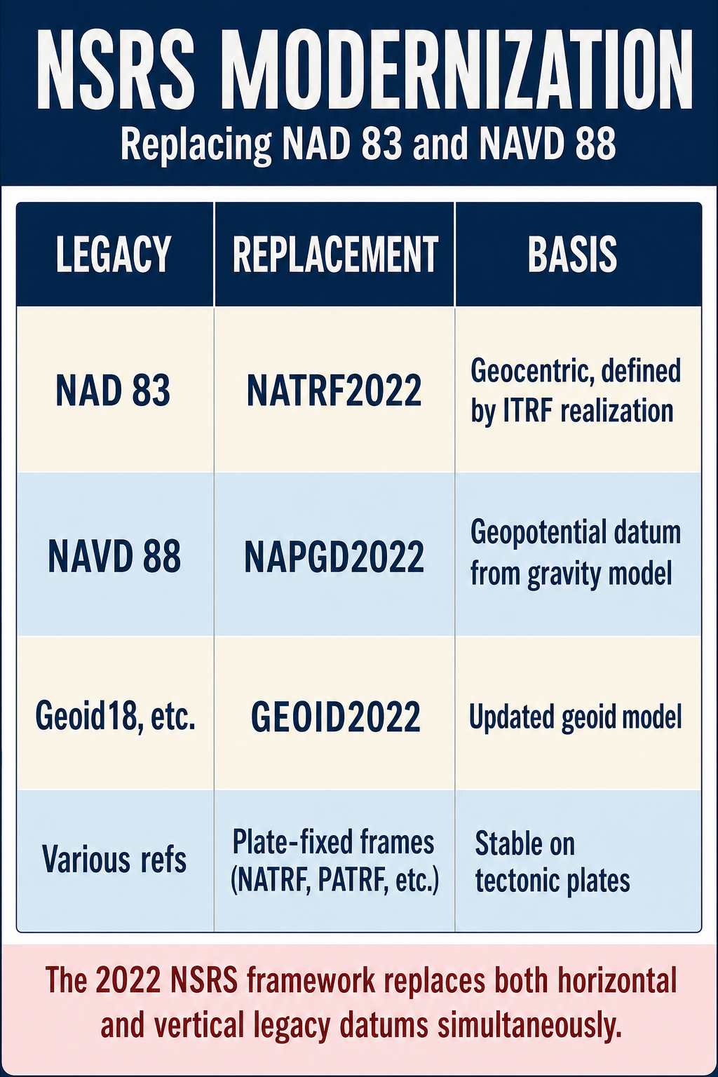
NGS is modernizing the National Spatial Reference System:
NATRF2022 (North American Terrestrial Reference Frame of 2022):
- Will replace NAD 83 as the horizontal datum
- Will be a plate-fixed, ITRF-aligned reference frame
- Coordinates will be time-dependent (velocities published for each point to account for tectonic motion)
NAPGD2022 (North American-Pacific Geopotential Datum of 2022):
- Will replace NAVD 88 as the vertical datum
- Based on a gravimetric geoid model rather than leveling
- Will allow GNSS to determine orthometric heights directly (with geoid model)
- Eliminates the need for extensive leveling networks
Exam Tips
- NAD 27 uses Clarke 1866 (local datum, Meades Ranch origin); NAD 83 uses GRS 80 (geocentric datum)
- NAD 27 and NAD 83 coordinates for the same point can differ by tens to hundreds of meters -- never mix them
- WGS 84 is practically identical to NAD 83 at the 1-2 meter level; for higher accuracy, they differ
- NGVD 29 and NAVD 88 differ by 0 to 0.5+ meters; the difference varies by location
- NADCON converts horizontal coordinates between NAD 27 and NAD 83
- VERTCON converts elevations between NGVD 29 and NAVD 88
- Every coordinate or elevation must specify its datum -- a number without a datum is meaningless
- The FS exam may ask about the characteristics of each datum, the differences between them, or why transformation is necessary
- Newer NAD 83 realizations (2011, CORS96) are more accurate than the original 1986 adjustment
- The upcoming NATRF2022 will be time-dependent to account for tectonic motion
Related Test Topics
- Geodetic Coordinates and Surfaces (Topic 4.4)
- State Plane Coordinates (Topic 4.6)
- GNSS/GPS Methods (Module 1, Topic 1.3)
- Vertical Surveys and Leveling (Topic 4.2)
Further Reading
Authoritative sources for deeper study
NGS Geodetic Glossary (1986, NOAA repository) — Authoritative definitions for geodetic, GNSS, and surveying terms.
NOAA Manual NOS NGS 5 — State Plane Coordinate System of 1983 — Definitive NGS reference for SPCS83 zone constants, projections, and conversions.
Wolf & Ghilani, Elementary Surveying — An Introduction to Geomatics (13th Ed., 2012) — Comprehensive surveying text covering instruments, field procedures, and computations.
Last updated: 2026-04-17