FS Exam Preparation
Comprehensive preparation for the Fundamentals of Surveying (FS) exam. 7 modules covering all 7 exam domains with 60 in-depth topics.
Module 1: Surveying Processes & Methods
Module 2: Mapping Processes & Methods
Module 3: Boundary Law & Real Property
Module 4: Surveying Principles & Geodesy
Module 5: Survey Computations
Module 6: Business Concepts
Public Land Survey System (PLSS)
Learning Objectives
After completing this topic, you should be able to:
- Describe the structure of the Public Land Survey System
- Identify townships, ranges, and sections from a PLSS description
- Explain how sections are subdivided into aliquot parts
- Understand the rules for restoring lost and obliterated corners
- Describe the role of the BLM Manual of Surveying Instructions
- Calculate areas of standard and fractional sections and aliquot parts
Overview
The Public Land Survey System (PLSS) is the rectangular survey system used to subdivide public domain lands in the United States. Established by the Land Ordinance of 1785, the PLSS covers 30 of the 50 states (primarily the states west of the Appalachian Mountains, excluding the original 13 colonies and a few others). The PLSS created the foundational framework upon which millions of property boundaries are based.
The FS exam heavily tests PLSS concepts because the system underlies most western U.S. property descriptions.
Key Concepts
Structure of the PLSS
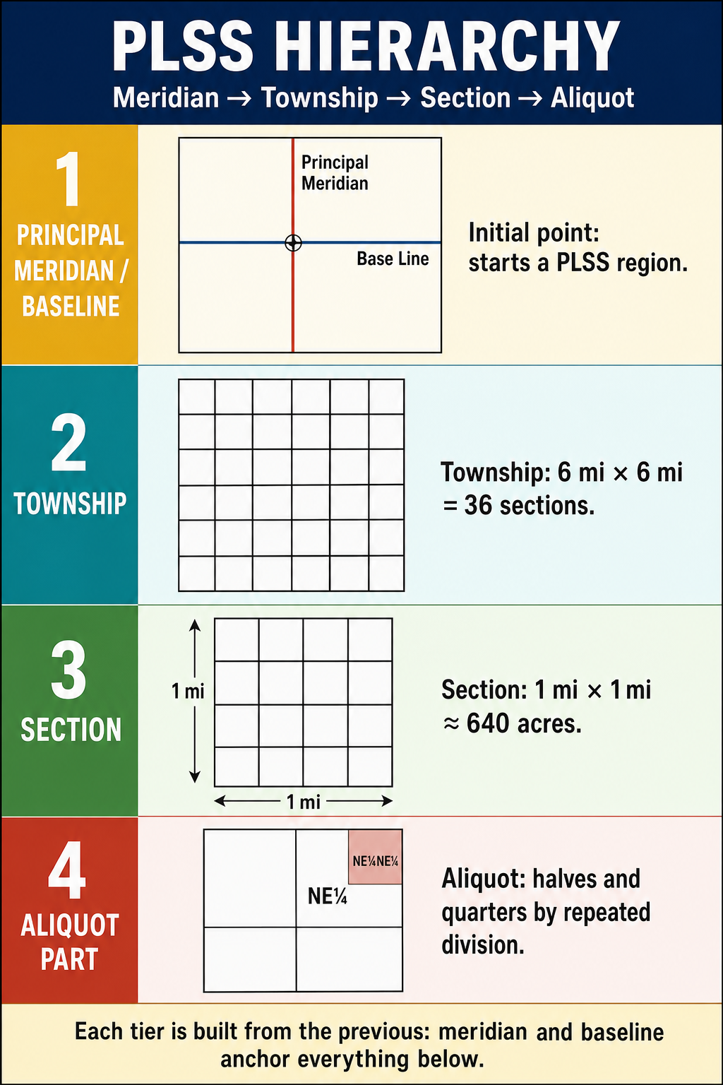
The PLSS is organized in a hierarchy:
Initial point: Each PLSS survey begins at an initial point (approximately 37 principal meridians, each anchored by an initial point), from which a principal meridian (running north-south) and a base line (running east-west) are established.
Township and range grid:
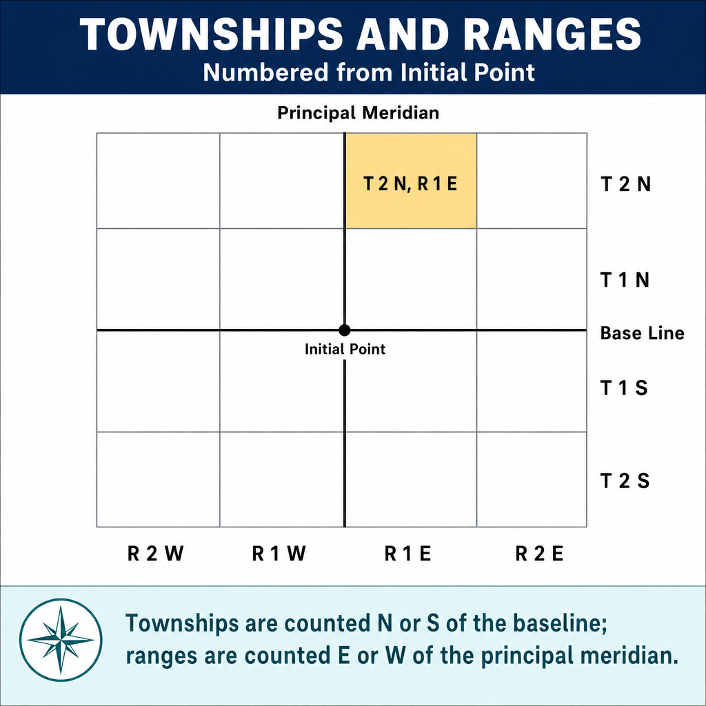
- Townships are rows of 6-mile-square blocks measured north and south of the base line (e.g., T3N = Township 3 North)
- Ranges are columns measured east and west of the principal meridian (e.g., R5W = Range 5 West)
- Each township-range combination identifies a unique 6-mile-square area
Sections:
- Each township is divided into 36 sections, each nominally 1 mile square (640 acres)
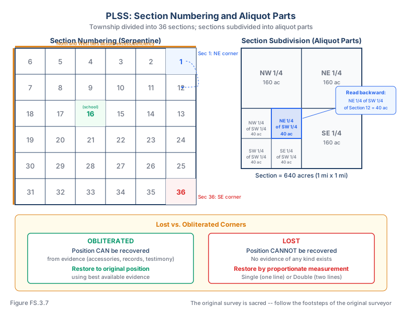
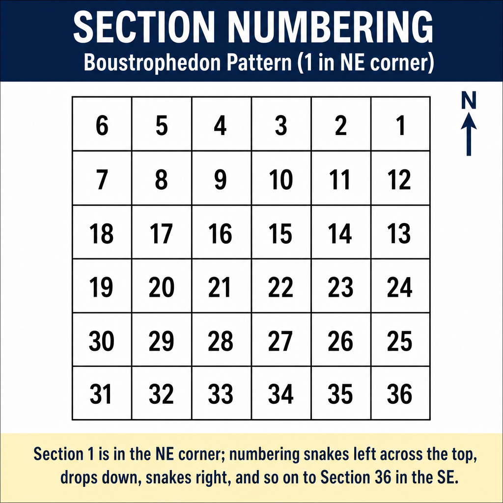
- Sections are numbered 1 through 36 in a serpentine pattern:
- Row 1 (north): 1-6 from east to west
- Row 2: 7-12 from west to east
- Row 3: 13-18 from east to west
- And so on through section 36
Section Numbering
 6 |  5 |  4 |  3 |  2 |  1
 7 |  8 |  9 | 10 | 11 | 12
18 | 17 | 16 | 15 | 14 | 13
19 | 20 | 21 | 22 | 23 | 24
30 | 29 | 28 | 27 | 26 | 25
31 | 32 | 33 | 34 | 35 | 36
Section 1 is in the northeast corner and Section 36 is in the southeast corner.
Aliquot Parts
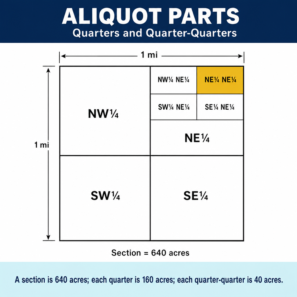
Sections are subdivided into aliquot parts (halves, quarters, and further subdivisions):
- Half section: 320 acres (e.g., N 1/2 of Section 10)
- Quarter section: 160 acres (e.g., NW 1/4 of Section 10)
- Quarter-quarter section: 40 acres (e.g., NE 1/4 of the NW 1/4 of Section 10)
- Further subdivisions are possible down to 2.5-acre parcels
Reading PLSS descriptions (read backward):
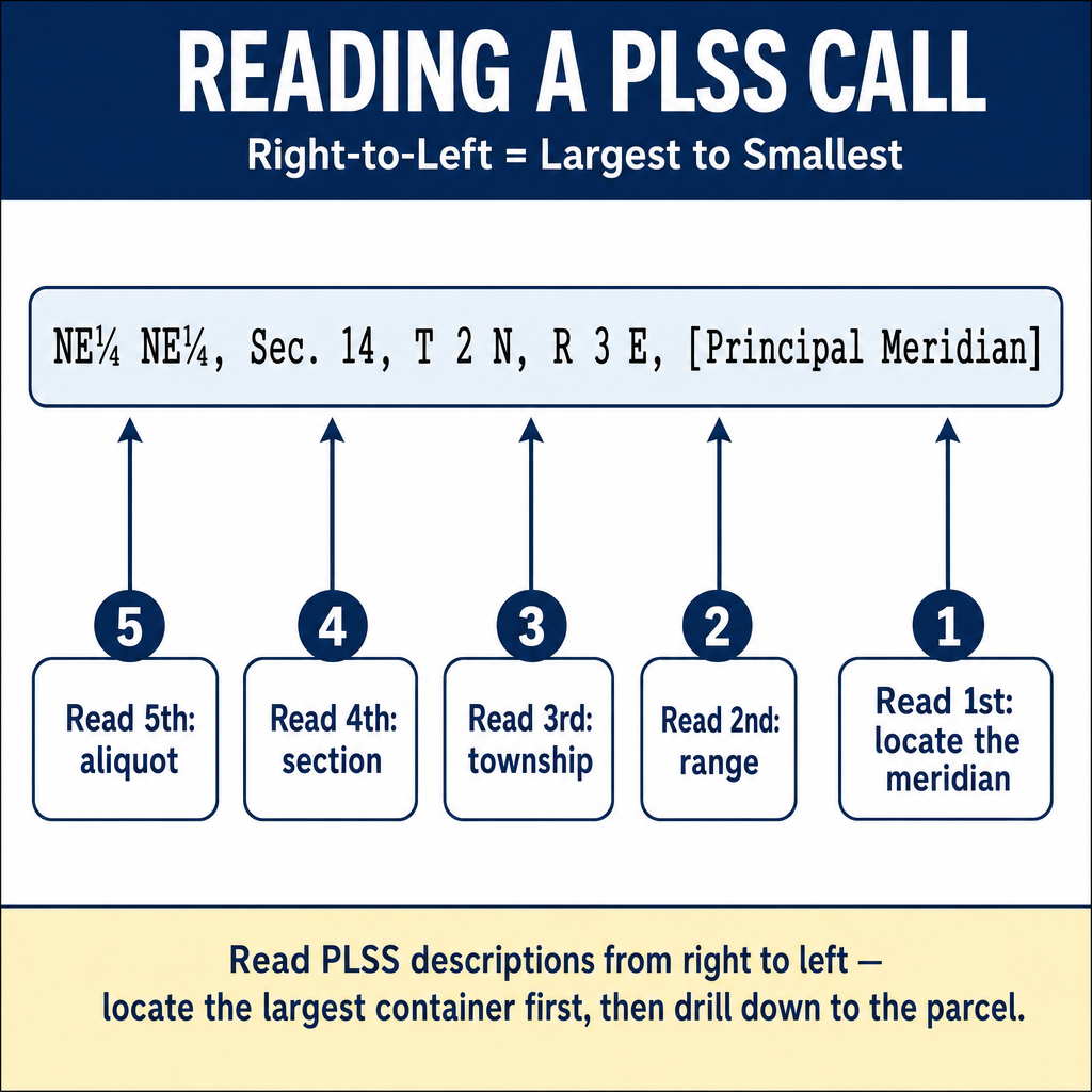
"The NE 1/4 of the SW 1/4 of Section 12, T3N, R5W, 5th Principal Meridian"
Read from the smallest division outward:
- Start with Section 12 in T3N, R5W
- Find the SW 1/4 of that section (lower left quarter)
- Find the NE 1/4 of that quarter (upper right of the SW quarter)
- This describes a 40-acre parcel
Area Calculations
Standard section: 640 acres (1 mile x 1 mile)
| Subdivision | Area |
|---|---|
| Section | 640 acres |
| Half section | 320 acres |
| Quarter section | 160 acres |
| Half of a quarter | 80 acres |
| Quarter-quarter | 40 acres |
| Half of a quarter-quarter | 20 acres |
| Quarter of a quarter-quarter | 10 acres |
Fractional sections: Sections along the north and west boundaries of a township absorb the excess or deficiency caused by the convergence of meridians. These sections may be larger or smaller than 640 acres.
Government lots: Fractional parcels that cannot be described as aliquot parts are designated as government lots and numbered on the township plat.
Common wrong path — reading the description forward. A description like "the NE 1/4 of the SW 1/4 of the SE 1/4 of Section 10" is read right to left: start with Section 10, find its SE 1/4 (a 160-acre square), then within that find the SW 1/4 (a 40-acre square in the southwest corner of the SE 1/4), then within that find the NE 1/4 (a 10-acre square in the northeast corner of that 40). Students who read left-to-right or parse the words in order of appearance often end up in the wrong quarter-quarter. A fast way to verify: the total acreage is acres. Each "1/4" quarters the previous result. The final result is always located by nesting from the outside in: the outermost division appears last in the text. Exam questions test this by giving a multi-level aliquot description and asking for area or location — practice until your brain parses right-to-left automatically.
Quick retrieval check — try before reading on.
▶What is the area of "the W 1/2 of the NW 1/4 of the NE 1/4 of Section 16," and where is it located within the section?
Area: acres. Read right-to-left: find Section 16 → find the NE 1/4 (northeast 160 acres) → within that, find the NW 1/4 (the northwest 40 acres, which sits in the north-central portion of the section, with its western edge along the section's N-S centerline) → within that, find the W 1/2 (the west 20 acres of that 40-acre square). The parcel is a 20-acre rectangle along the north edge of the section, immediately east of the section's N-S centerline (because the NE 1/4 lies east of the centerline by definition), measuring 660 ft E-W by 1,320 ft N-S (0.125 mi × 0.25 mi).
Corner Types
| Corner Type | Description |
|---|---|
| Township corner | At the intersection of township and range lines |
| Section corner | At the intersection of section lines; controls up to 4 sections |
| Quarter-section corner | Midpoint of each section line; controls the quarter-section divisions |
| Meander corner | Set where a section or township line intersects a meanderable body of water |
| Witness corner | Set on a survey line near the true corner position when the true corner cannot be monumented (e.g., falls in a lake or steep terrain) |
| Reference monument | Auxiliary monument set to aid in recovering the corner |
Lost and Obliterated Corners
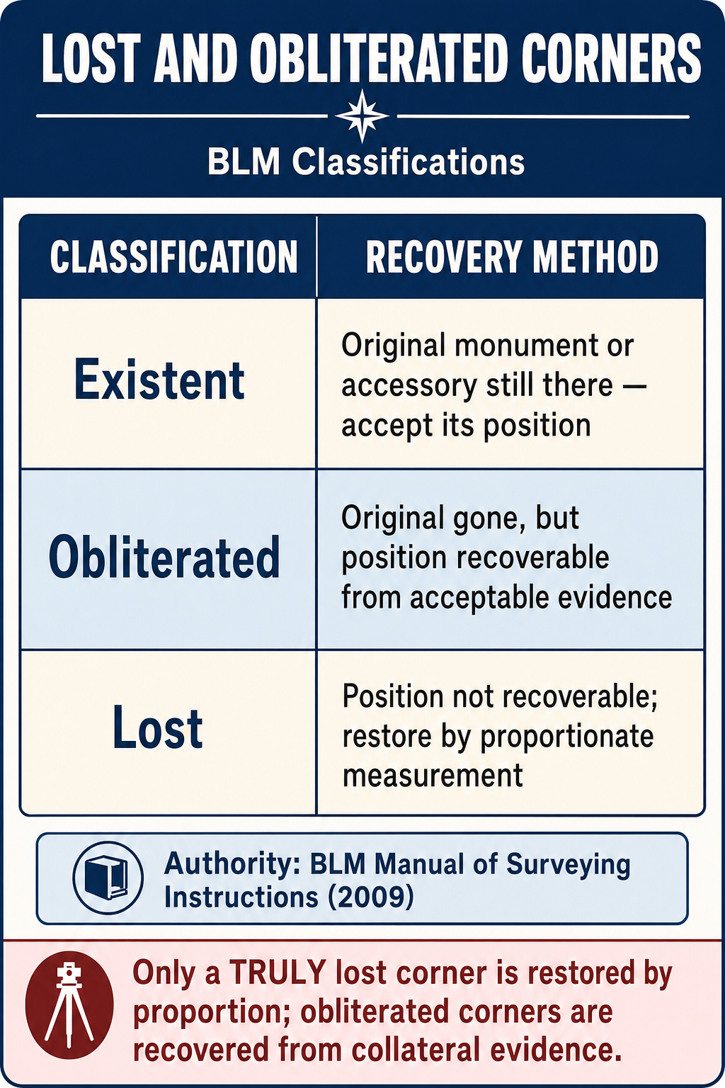
Obliterated corner: A corner whose position can be recovered from evidence of the original monument or its accessories (bearing trees, reference monuments, survey records, testimony) (BLM Manual of Surveying Instructions, 2009, §6-17).
Lost corner: A corner whose position cannot be recovered from any evidence. A corner is not considered lost if any evidence exists to establish its position (BLM Manual, 2009, §6-17).
Restoration rules (from the BLM Manual, 2009, Ch. VII):
- An obliterated corner is restored to its original position using the best available evidence
- A lost corner is restored by proportionate measurement -- distributing the difference between record and measured distances proportionally (BLM Manual §§7-8 through 7-12)
Types of proportionate measurement (BLM Manual §§7-16 ff.):
- Single proportionate measurement: Used when the lost corner is on a line between two existing corners (the distance is distributed proportionally along that line)
- Double proportionate measurement: Used when the lost corner is at the intersection of two lines (requires proportioning in two directions: north-south and east-west)
Key PLSS Principles
- The original survey controls -- the retracing surveyor follows the footsteps of the original surveyor
- Monuments control over measurements in the original survey
- Convergence of meridians causes townships to be narrower at the north than at the south
- Standard parallels (correction lines) are run every 24 miles (4 townships) to limit the accumulation of convergence
- The north and west tiers of sections in each township absorb excess or deficiency
Exam Tips
- Section 1 is in the northeast corner; section 36 is in the southeast corner; sections are numbered in a serpentine pattern
- Read PLSS descriptions from the smallest division outward (right to left in the text)
- A quarter-quarter section is 40 acres -- this is the most common FS exam calculation
- Obliterated corners can be recovered from evidence; lost corners cannot and require proportionate measurement
- Single proportionate measurement uses one line; double proportionate measurement uses two intersecting lines
- The original survey is sacred -- the retracing surveyor does not create new boundaries
- Fractional sections appear along the north and west boundaries of a township
- Government lots are fractional parcels that cannot be described as standard aliquot parts
- A witness corner is set when the true corner location is inaccessible; it is set on the survey line near the corner position
- The FS exam commonly tests section numbering, aliquot part calculations, and the distinction between lost and obliterated corners
Related Test Topics
- Controlling Elements and Evidence (Topic 3.2)
- Metes and Bounds Descriptions (Topic 3.6)
- Cadastral and Boundary Surveys (Module 1, Topic 1.6)
- Public Records and Descriptions (Topic 3.1)
Further Reading
Authoritative sources for deeper study
BLM Manual of Surveying Instructions (2009) — Federal authority on PLSS surveys, corner restoration, and rectangular system.
Mulford, Boundaries and Landmarks — Classic public-land-system boundary reference (public domain).
Robillard & Bouman, A Treatise on the Public Land Surveying System / Public Land Surveying Casebook — Application of BLM Manual principles in the field.
Last updated: 2026-04-17