FS Exam Preparation
Comprehensive preparation for the Fundamentals of Surveying (FS) exam. 7 modules covering all 7 exam domains with 60 in-depth topics.
Module 1: Surveying Processes & Methods
Module 2: Mapping Processes & Methods
Module 3: Boundary Law & Real Property
Module 4: Surveying Principles & Geodesy
Module 5: Survey Computations
Module 6: Business Concepts
Metes & Bounds Descriptions
Learning Objectives
After completing this topic, you should be able to:
- Define metes and bounds and identify the components of a description
- Interpret bearing and distance calls in a legal description
- Identify the point of beginning (POB) and its requirements
- Recognize ambiguities and defects in legal descriptions
- Understand curve descriptions in metes and bounds
- Trace a metes and bounds description on paper or in coordinates
Overview
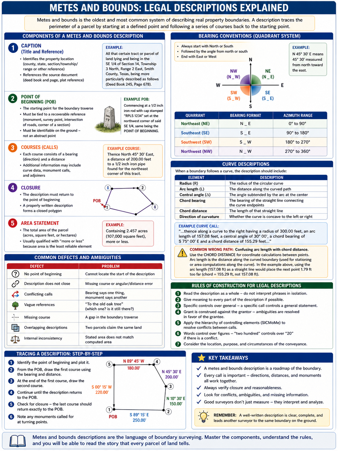
Metes and bounds is the oldest and most common system of describing real property boundaries. "Metes" refers to measurements (distances and directions), and "bounds" refers to boundaries (natural and artificial features that define the limits of the property). A metes and bounds description traces the perimeter of a parcel by starting at a defined point and following a series of courses (direction and distance pairs) back to the starting point.
Understanding metes and bounds descriptions is essential for every surveyor. The FS exam tests your ability to read, interpret, and identify issues in legal descriptions.
Key Concepts
Components of a Metes and Bounds Description
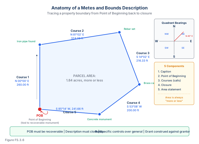
A well-written description includes:
1. Caption (title and reference):
- Identifies the property location (county, state, section/township/range or other reference)
- References the source document (deed book and page, plat reference)
2. Point of beginning (POB):
- The starting point for the boundary traverse
- Must be tied to a recoverable reference (monument, survey point, intersection of roads, corner of a section)
- Must be identifiable on the ground -- not an abstract point
3. Courses (calls):
- Each course consists of a bearing (direction) and a distance
- Additional information may include curve data, monument calls, and adjoiners
- Example: "North 45 degrees 30 minutes East, a distance of 200.00 feet to an iron pipe"
4. Closure:
- The description must return to the point of beginning
- A properly written description forms a closed polygon
5. Area statement:
- The total area of the parcel (in acres, square feet, or hectares)
- Usually qualified with "more or less" because area is the least reliable element
Bearing Conventions
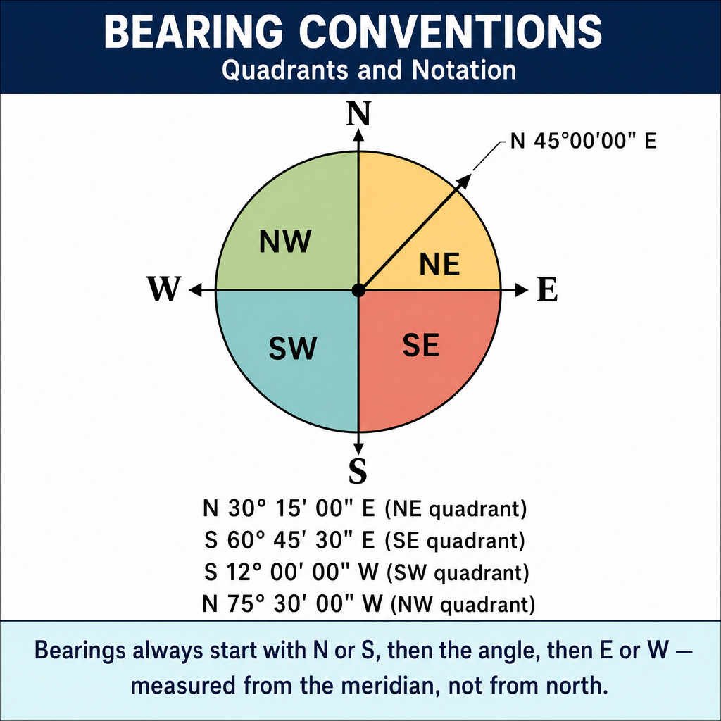
Bearings in legal descriptions use the quadrant system:
- Always start with North or South
- Followed by the angle from north or south
- End with East or West
- Example: N 45° 30' E means 45 degrees 30 minutes measured from north toward the east
The four quadrants:
| Quadrant | Bearing Format | Azimuth Range |
|---|---|---|
| Northeast | N _ E | 0 to 90 degrees |
| Southeast | S _ E | 90 to 180 degrees |
| Southwest | S _ W | 180 to 270 degrees |
| Northwest | N _ W | 270 to 360 degrees |
Curve Descriptions
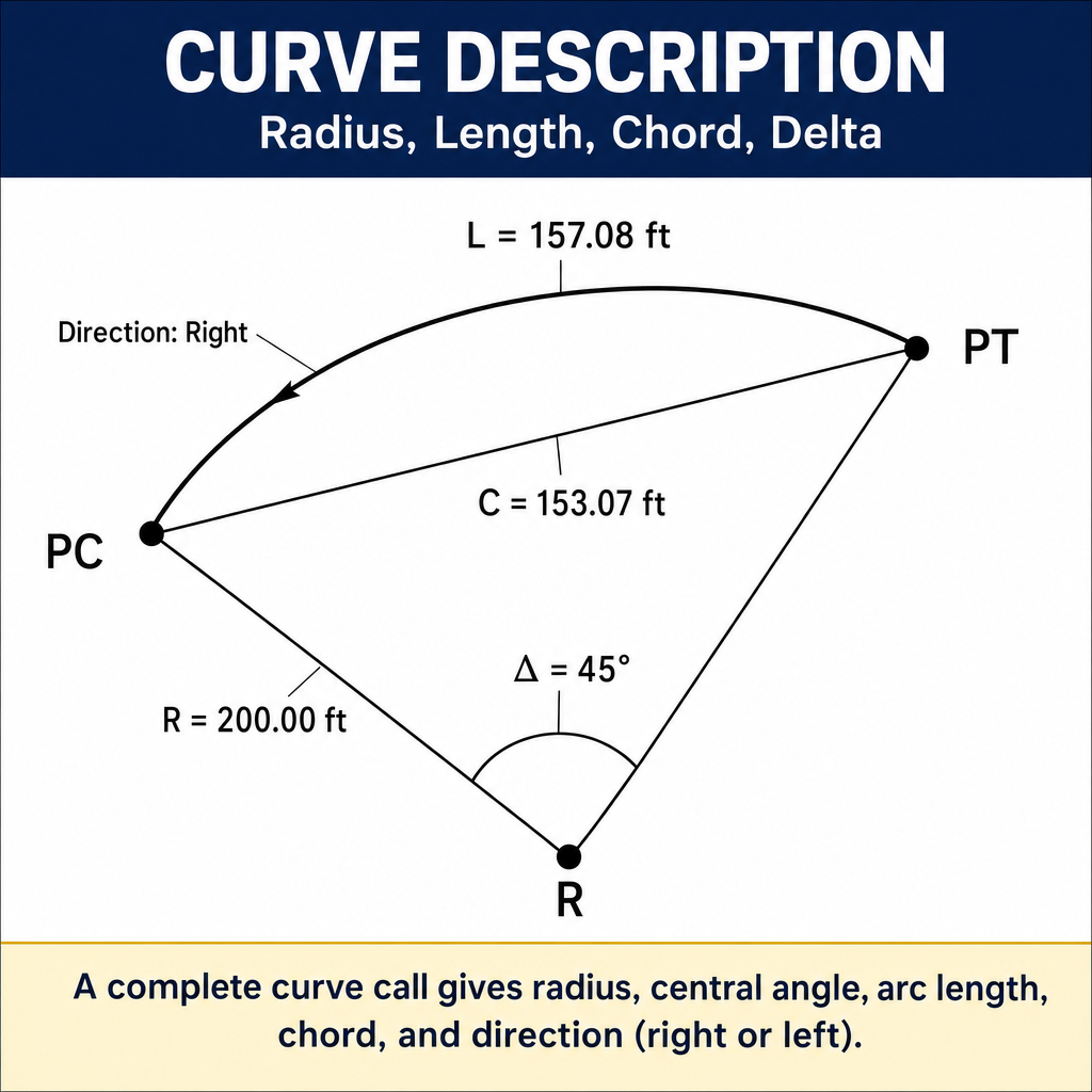
When a boundary follows a curve (common along roads and waterfront), the description should include:
| Element | Description |
|---|---|
| Radius (R) | The radius of the circular curve |
| Arc length (L) | The distance along the curved path |
| Central angle (delta) | The angle subtended by the arc at the center of the circle |
| Chord bearing | The bearing of the straight line connecting the curve endpoints |
| Chord distance | The length of that straight line |
| Direction of curvature | Whether the curve is concave to the left or right |
Example: "...thence along a curve to the right having a radius of 300.00 feet, an arc length of 157.08 feet, a central angle of 30 degrees 00 minutes, a chord bearing of S 75 degrees 00 minutes E and a chord distance of 155.29 feet..."
Common wrong path — confusing arc length with chord distance. A curve call like "along a curve having a radius of 300 ft, arc length 157.08 ft" describes a curved path. If you treat the 157.08 ft as a straight-line distance and plot it along the chord bearing, you'll position the next point 1.79 ft too far (chord = 155.29, not 157.08). Exam questions plant this trap by listing the full curve data and asking you to compute the coordinates of the next turning point — you must use the chord to go point-to-point along a straight line, and the arc only for stationing or area computations along the curve. Read the description: "thence along a curve" means you're following the curved boundary; the specific value you plug into coordinate math depends on which element you need (chord for point position, arc for length along the curve).
Quick retrieval check — try before reading on.
▶A boundary curve has R = 500 ft, delta (central angle) = 60° 00'. What are the arc length and chord length? If you used the arc length to plot the curve's endpoint from its start point, how far off would you be?
Arc length ft.
Chord ft.
Using the 523.60 ft arc length as if it were a chord places the endpoint 523.60 − 500.00 = 23.60 ft past the true endpoint. For a 60° central angle the chord is notably shorter than the arc — the difference grows with delta. For small delta (under 10°), chord and arc agree within ~1%; for large delta (above 30°), the difference is exam-relevant.
Common Defects and Ambiguities
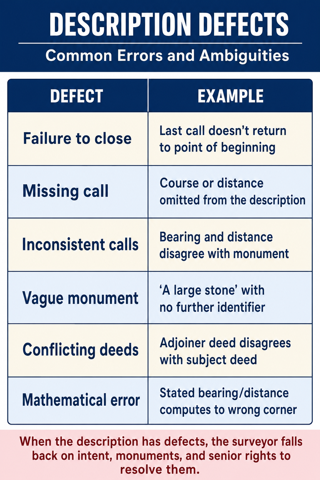
| Defect | Problem |
|---|---|
| No point of beginning | Cannot locate the start of the description |
| Description does not close | Missing course or angular/distance error |
| Conflicting calls | Bearing says one thing, monument says another |
| Vague references | "To the old oak tree" (which one? is it still there?) |
| Missing course | A gap in the boundary traverse |
| Overlapping descriptions | Two parcels claim the same land |
| Internal inconsistency | Stated area does not match computed area |
Rules of Construction for Legal Descriptions
When interpreting ambiguous or conflicting descriptions:
- Read the description as a whole -- do not interpret phrases in isolation
- Give meaning to every part of the description if possible
- Specific controls over general -- a specific call controls a general statement
- Grant is construed against the grantor -- ambiguities are resolved in favor of the grantee
- Apply the hierarchy of controlling elements (SICMoMe) to resolve conflicts between calls
- Words control over figures -- "two hundred" controls over "20" if there is a conflict
Tracing a Description
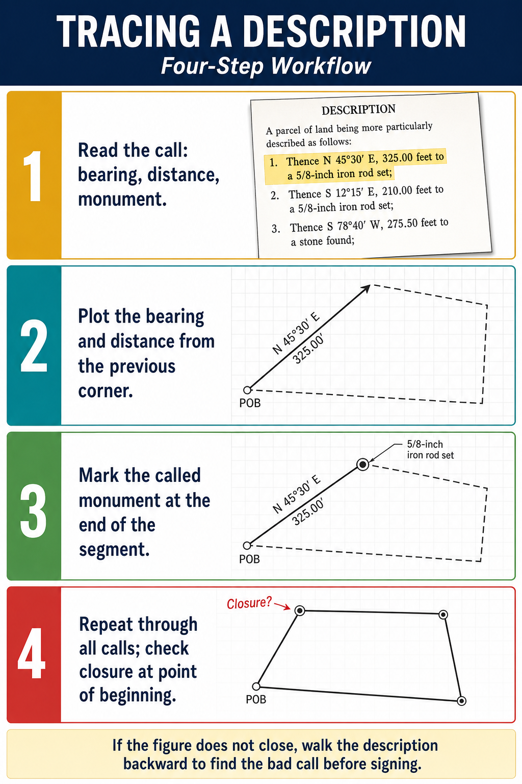
To trace a metes and bounds description:
- Identify the point of beginning and plot it
- From the POB, draw the first course using the bearing and distance
- At the end of the first course, draw the second course
- Continue until the description returns to the POB
- Check for closure -- the last course should return exactly to the POB
- Note any monuments called for at turning points
Exam Tips
- The POB must be tied to a recoverable reference -- it cannot be an undefined point in space
- Bearings use the quadrant system (N/S first, then angle, then E/W)
- A proper description closes on itself -- returning to the POB
- Area is the least reliable element and is usually qualified with "more or less"
- Curves are typically described in plats and deeds using five elements (radius, arc length, central angle, chord bearing, chord distance); geometrically only two of {R, Δ, L, C, T, E, M} are required to compute the rest, but listing several aids redundancy checking
- When deed calls conflict, apply SICMoMe to resolve (monuments over measurements, etc.)
- Grant is construed against the grantor in cases of ambiguity
- The FS exam may ask you to identify defects in a description, interpret a bearing, or trace a description to find a missing course
- Know how to convert between quadrant bearings and azimuths
Related Test Topics
- Controlling Elements and Evidence (Topic 3.2)
- PLSS Fundamentals (Topic 3.7)
- Public Records and Descriptions (Topic 3.1)
- Conveyances and Title Transfer (Topic 3.5)
Further Reading
Authoritative sources for deeper study
Wattles, Writing Legal Descriptions (1976) — Gold-standard reference on metes-and-bounds, sectional, and combination descriptions.
Brown's Boundary Control and Legal Principles (7th Ed., Robillard & Wilson) — Standard textbook on boundary law, evidence hierarchy, and retracement.
Evidence and Procedures for Boundary Location (Robillard, Wilson, & Brown, 6th Ed., 2011) — Practical treatise on collecting, weighing, and applying boundary evidence.
Last updated: 2026-04-17