FS Exam Preparation
Comprehensive preparation for the Fundamentals of Surveying (FS) exam. 7 modules covering all 7 exam domains with 60 in-depth topics.
Module 1: Surveying Processes & Methods
Module 2: Mapping Processes & Methods
Module 3: Boundary Law & Real Property
Module 4: Surveying Principles & Geodesy
Module 5: Survey Computations
Module 6: Business Concepts
GNSS/GPS Surveying Methods
Learning Objectives
After completing this topic, you should be able to:
- Describe the segments of GNSS and how satellite positioning works
- Distinguish between code-based and carrier-phase positioning
- Explain the major GNSS observation methods (static, rapid-static, RTK, PPP)
- Identify factors that affect GNSS accuracy
- Plan GNSS observations considering satellite geometry and DOP
- Understand the coordinate systems used in GNSS (WGS 84, ITRF, NAD 83)
Overview
Global Navigation Satellite Systems (GNSS) have transformed surveying by providing three-dimensional positioning anywhere on earth, at any time, without requiring line of sight between points. The term GNSS encompasses all satellite navigation systems: GPS (United States), GLONASS (Russia), Galileo (European Union), and BeiDou (China).
For the FS exam, you must understand the fundamental principles of satellite positioning, the different observation methods, and the factors that affect accuracy. GNSS is now used in virtually every branch of surveying, from control networks to machine guidance.
Key Concepts
The Three Segments of GPS
Space segment:
- 31+ operational GPS satellites (as of 2025) in six orbital planes
- Orbit altitude: approximately 20,200 km (12,550 miles)
- Orbital period: approximately 11 hours 58 minutes (half a sidereal day)
- Each satellite transmits on L1 (1575.42 MHz) and L2 (1227.60 MHz) frequencies; modernized satellites also transmit L5 (1176.45 MHz)
Control segment:
- Master control station (Schriever Space Force Base, formerly Schriever AFB, Colorado) plus monitor stations worldwide
- Tracks satellites, computes ephemerides and clock corrections
- Uploads corrected data to satellites
User segment:
- All GPS receivers on or near earth
- Receivers measure the signals from satellites and compute positions
How Satellite Positioning Works
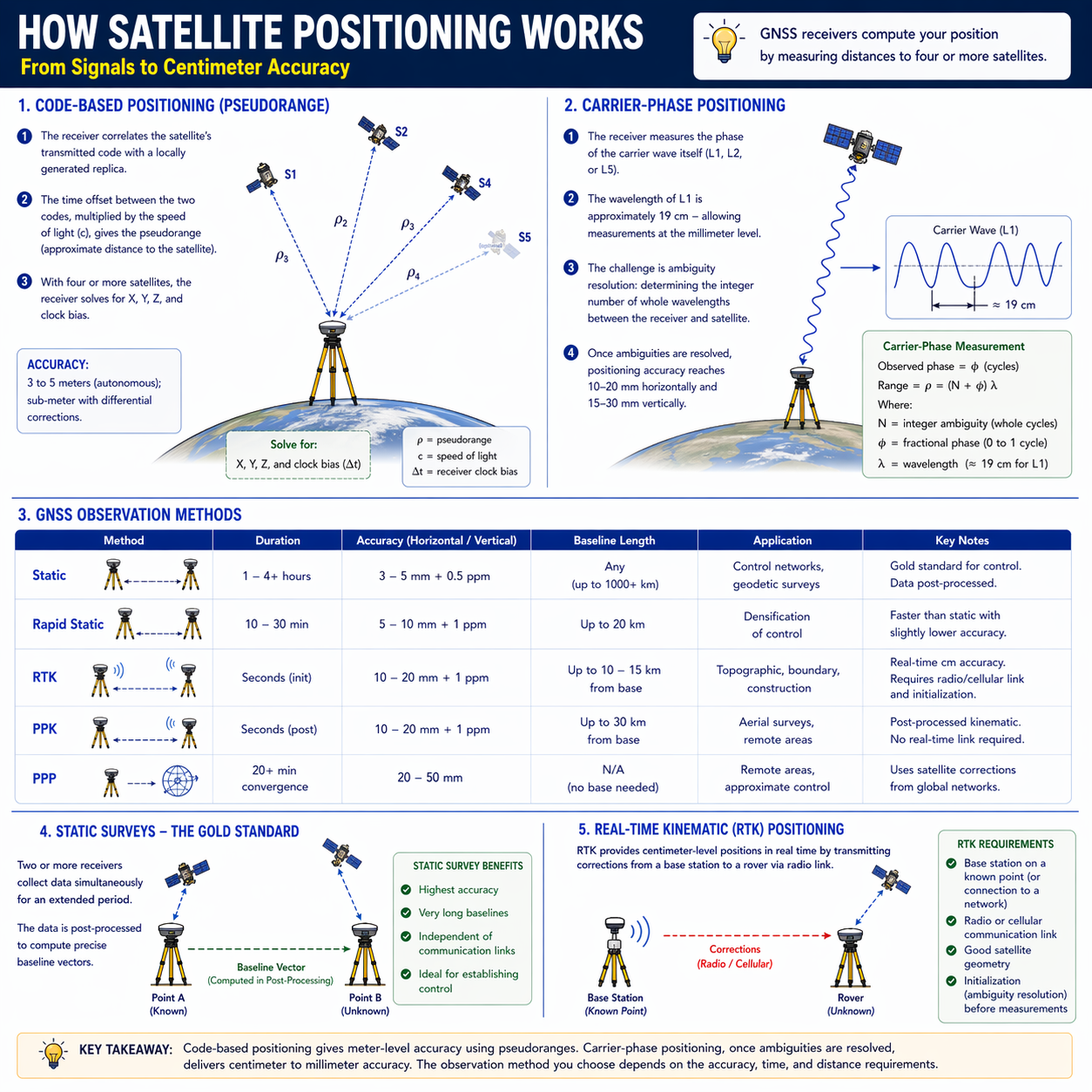
Code-based positioning (pseudorange):
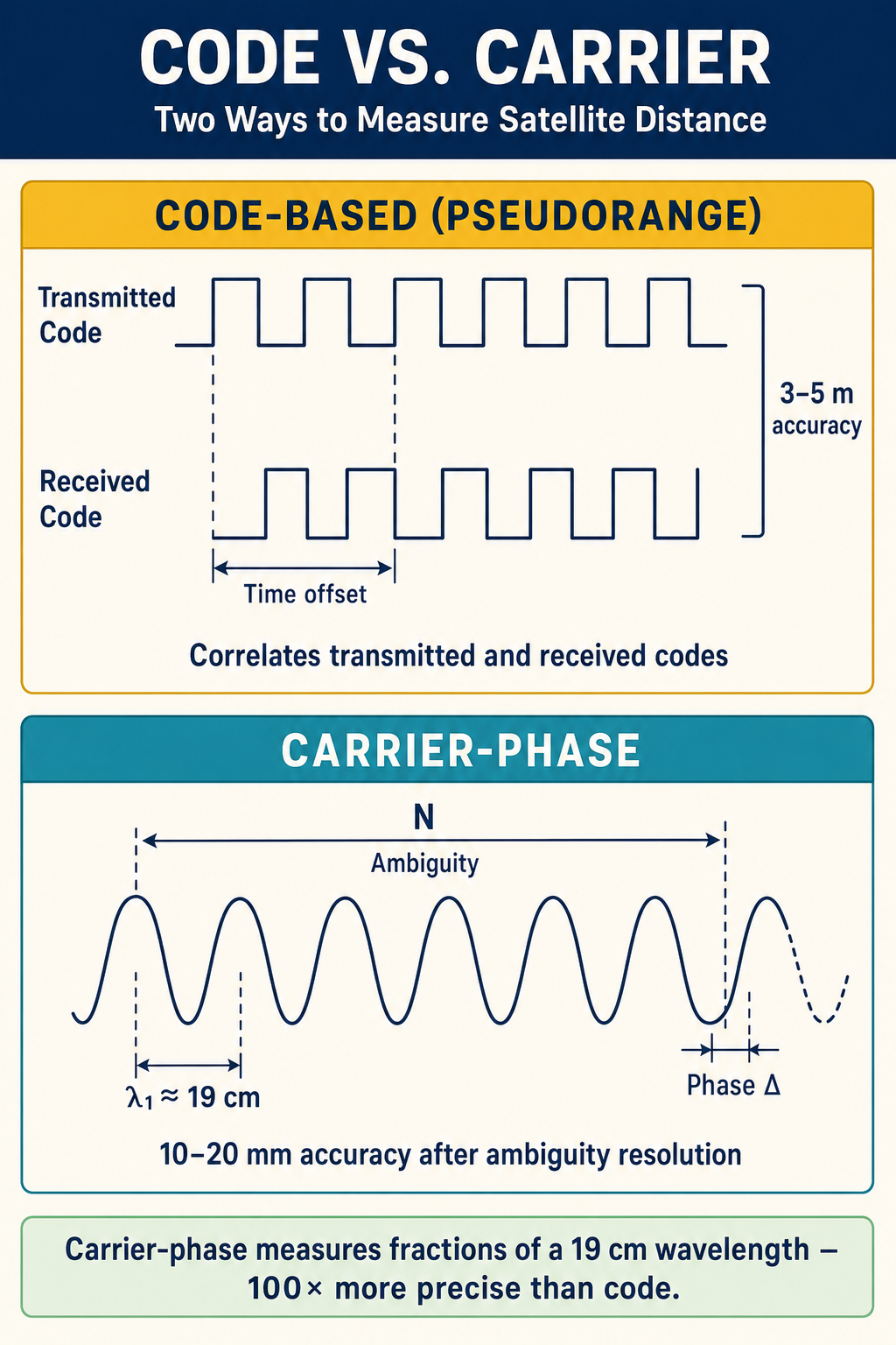
- The receiver correlates the satellite's transmitted code with a locally generated replica
- The time offset between the two codes, multiplied by the speed of light, gives the pseudorange (approximate distance to the satellite)
- With four or more satellites, the receiver solves for X, Y, Z, and clock bias
- Accuracy: 3 to 5 meters (autonomous); sub-meter with differential corrections
Carrier-phase positioning:
- The receiver measures the phase of the carrier wave itself (L1, L2, or L5)
- The wavelength of L1 is approximately 19 cm -- allowing measurements at the millimeter level
- The challenge is ambiguity resolution: determining the integer number of whole wavelengths between the receiver and satellite
- Once ambiguities are resolved, positioning accuracy reaches 10-20 mm horizontally and 15-30 mm vertically
GNSS Observation Methods
| Method | Duration | Accuracy | Baseline Length | Application |
|---|---|---|---|---|
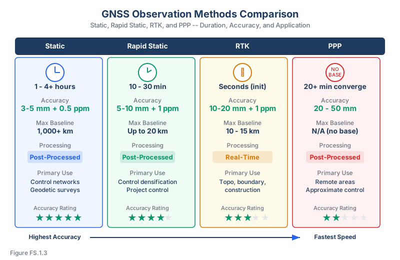
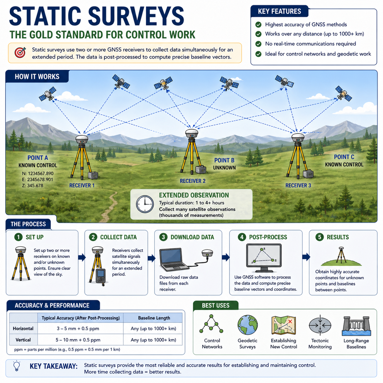
| Static | 1-4+ hours | 3-5 mm + 0.5 ppm | Any (up to 1000+ km) | Control networks, geodetic surveys |
| Rapid Static | 10-30 min | 5-10 mm + 1 ppm | Up to 20 km | Densification of control |
| RTK | Seconds (init) | 10-20 mm + 1 ppm | Up to 10-15 km from base | Topographic, boundary, construction |
| PPK | Seconds (post) | 10-20 mm + 1 ppm | Up to 30 km from base | Aerial surveys, remote areas |
| PPP | 20+ min convergence | 20-50 mm | N/A (no base needed) | Remote areas, approximate control |
Accuracy ranges are from Van Sickle, GPS for Land Surveyors (4th Ed.), Ch. 5, consistent with NGS guidance for static and kinematic GNSS surveys.
Static surveys are the gold standard for control work. Two or more receivers collect data simultaneously for an extended period. The data is post-processed to compute precise baseline vectors.
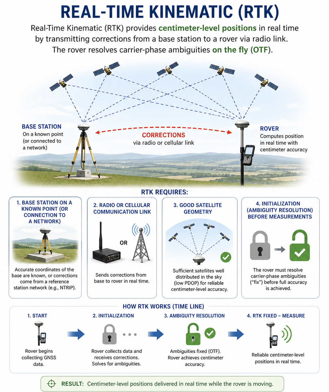
Real-Time Kinematic (RTK) provides centimeter-level positions in real time by transmitting corrections from a base station to a rover via radio link. The rover resolves carrier-phase ambiguities on the fly (OTF). RTK requires:
- A base station on a known point (or connection to a network)
- Radio or cellular communication link
- Good satellite geometry
- Initialization (ambiguity resolution) before measurements
Satellite Geometry and DOP
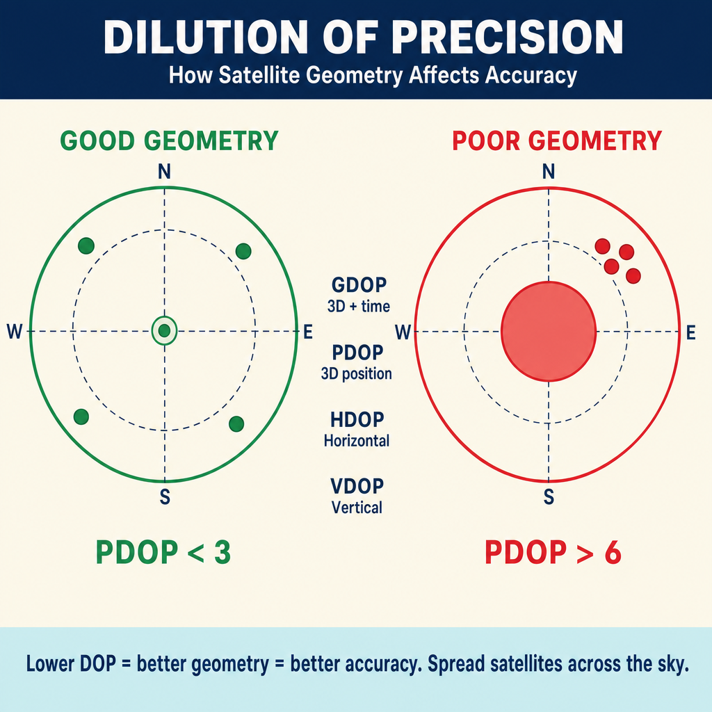
Dilution of Precision (DOP) describes how satellite geometry affects positioning accuracy. A lower DOP value indicates better geometry.
| DOP Type | Measures |
|---|---|
| GDOP | Overall 3D position + time |
| PDOP | 3D position (X, Y, Z) |
| HDOP | Horizontal position only |
| VDOP | Vertical position only |
Good geometry means satellites are spread across the sky -- not clustered together. A PDOP below 3 is considered good; above 6 is poor.
Factors that degrade geometry:
- Obstructions (buildings, trees, canyon walls) blocking satellite signals
- Low satellite count above the elevation mask
- Satellites clustered in one part of the sky
Coordinate Systems in GNSS
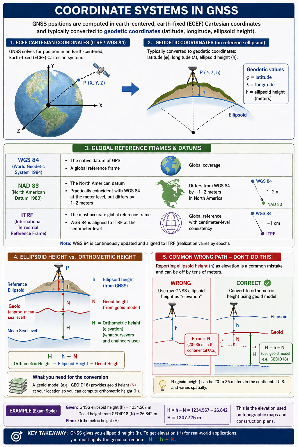
GNSS positions are computed in earth-centered, earth-fixed (ECEF) Cartesian coordinates and typically converted to geodetic coordinates (latitude, longitude, ellipsoid height).
- WGS 84 -- the native datum of GPS; a global reference frame
- NAD 83 -- the North American datum; practically coincident with WGS 84 at the meter level, but differs by 1-2 meters
- ITRF -- the International Terrestrial Reference Frame; the most accurate global reference frame; WGS 84 is aligned to ITRF at the centimeter level
Ellipsoid height vs. orthometric height:
- GNSS measures ellipsoid height (height above the reference ellipsoid)
- Surveyors and engineers need orthometric height (height above the geoid, approximating mean sea level)
- The difference is the geoid height (N): Orthometric Height = Ellipsoid Height - Geoid Height
- A geoid model (e.g., GEOID18) is required for this conversion
Common wrong path — reporting ellipsoid height as elevation. GNSS receivers natively output ellipsoid height (h). Elevation on a topographic or construction plan is almost always orthometric height (H), measured from the geoid (approximately mean sea level). The difference — geoid height N — can be 20 to 35 meters in the continental U.S. and varies spatially. A student who reads the raw GNSS ellipsoid height and reports it as "elevation" will be off by tens of meters — obviously wrong for a stakeout benchmark, but easy to overlook if the receiver output isn't labeled. The conversion: H = h − N, where N comes from a geoid model like GEOID18. Exam questions set this up by giving you a GNSS height and asking for an orthometric elevation; if you skip the geoid correction, you'll pick the wrong answer.
Quick retrieval check — try before reading on.
▶A GNSS receiver gives an ellipsoid height of +145.62 m at a control point. The geoid model reports N = −26.87 m at that location (typical for the continental U.S., where the geoid is below the ellipsoid). What is the orthometric elevation?
. When N is negative (geoid below ellipsoid), subtracting N adds its magnitude — the orthometric height is larger than the ellipsoid height. If you used H = h + N mechanically with N treated as positive (26.87), you'd get 172.49 — correct by accident in this case. But if N were positive (rare in CONUS, common elsewhere), H = h − N would give the right sign and H = h + N would be wrong. Always apply the sign: H = h − N, taking N as reported by the geoid model including its sign.
Exam Tips
- GNSS measures ellipsoid heights, not orthometric heights -- you must apply a geoid model to convert
- RTK requires a minimum of 5 satellites for reliable ambiguity resolution (though 4 is the theoretical minimum for a 3D position)
- PDOP below 3 is good; above 6 is poor -- lower is better
- Static surveys are the most accurate GNSS method; RTK trades some accuracy for speed
- Know the difference between code (pseudorange) and carrier-phase measurements
- The L1 carrier wavelength is about 19 cm; the L2 wavelength is about 24 cm
- Multipath is a major GNSS error source in urban and reflective environments
- The FS exam may ask about observation planning (satellite availability, DOP, elevation masks)
Related Test Topics
- GNSS Corrections and Networks (Topic 1.4)
- Control Surveys and Standards (Topic 1.5)
- Datums and Conversions (Module 4, Topic 4.5)
Further Reading
Authoritative sources for deeper study
Van Sickle, GPS for Land Surveyors (4th Ed.), Ch. 5 — Static, kinematic, RTK, and network methods.
Penn State GEOG 862 — GPS and GNSS for Geospatial Professionals — Free open courseware covering GNSS fundamentals, observables, RTK, and network solutions.
Leica GPS Basics (1999) — Plain-language introduction to GPS principles and field methods.
NGS Geodetic Glossary (1986, NOAA repository) — Authoritative definitions for geodetic, GNSS, and surveying terms.
Last updated: 2026-04-17