FS Exam Preparation
Comprehensive preparation for the Fundamentals of Surveying (FS) exam. 7 modules covering all 7 exam domains with 60 in-depth topics.
Module 1: Surveying Processes & Methods
Module 2: Mapping Processes & Methods
Module 3: Boundary Law & Real Property
Module 4: Surveying Principles & Geodesy
Module 5: Survey Computations
Module 6: Business Concepts
Differential & Trigonometric Leveling
Learning Objectives
After completing this topic, you should be able to:
- Compute elevations using differential leveling (BS/FS/HI method)
- Calculate elevations using trigonometric leveling
- Apply curvature and refraction corrections
- Compute loop misclosure for a level circuit
- Distribute elevation corrections based on distance or number of setups
Overview
Leveling determines the difference in elevation between points. Differential leveling uses a level instrument to read vertical distances on graduated rods, producing highly accurate elevation differences. Trigonometric leveling uses measured vertical angles and slope distances to compute elevation differences, trading some accuracy for greater range and flexibility. Both methods appear frequently on the FS exam.
Key Concepts
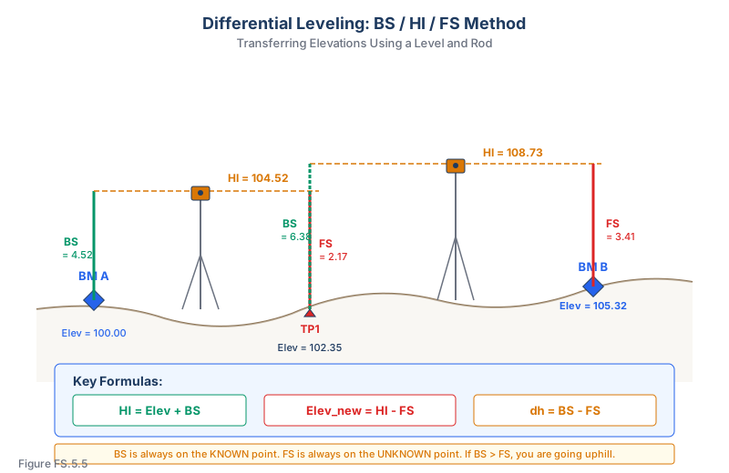
Differential Leveling
The fundamental process uses three values at each instrument setup:
- Backsight (BS): Rod reading on a point of known elevation
- Height of Instrument (HI): Elevation of the line of sight
- Foresight (FS): Rod reading on the point whose elevation is to be determined
Computations:
HI = Elevation_known + BS
Elevation_new = HI - FS
Difference in elevation:
dh = BS - FS
Turning Points
A turning point (TP) is a temporary point used to transfer elevation when the instrument must be moved. The process at each setup:
- Take a foresight (FS) on the turning point from the current setup
- Move the instrument to a new position
- Take a backsight (BS) on the same turning point from the new setup
- Compute the new HI
- Take a foresight on the next point
Level Circuit Closure
For a closed level loop (returns to the starting benchmark):
Misclosure = Final computed elevation - Known elevation
Allowable misclosure depends on the order of accuracy (Federal Geodetic Control Subcommittee, Standards and Specifications for Geodetic Control Networks, 1984):
| Order | Loop Closure (mm) | Loop Closure (ft) |
|---|---|---|
| First Order, Class I | 4 * sqrt(K) | 0.017 * sqrt(M) |
| First Order, Class II | 5 * sqrt(K) | 0.021 * sqrt(M) |
| Second Order, Class I | 6 * sqrt(K) | 0.025 * sqrt(M) |
| Second Order, Class II | 8 * sqrt(K) | 0.033 * sqrt(M) |
| Third Order | 12 * sqrt(K) | 0.050 * sqrt(M) |
Where K = one-way distance in km, M = one-way distance in miles. (Section tolerances are tighter: 3 mm * sqrt(K) for First Order Class I.)
Distributing Elevation Corrections
If the misclosure is within tolerance, distribute the error:
By distance:
Correction at point i = -(misclosure) * (distance to point i / total circuit distance)
By number of setups:
Correction at point i = -(misclosure) * (number of setups to point i / total setups)
Trigonometric Leveling
When a slope distance (S) and vertical angle (alpha) are measured:
Elevation difference:
dh = S * sin(alpha) + HI_instrument - HT_target
Where:
- S = slope distance
- alpha = vertical angle (positive above horizontal, negative below)
- HI_instrument = height of instrument above the occupied point
- HT_target = height of target/prism above the remote point
Alternatively, with zenith angle (z):
dh = S * cos(z) + HI_instrument - HT_target
Where z = zenith angle (0 at zenith, 90 at horizontal).
Curvature and Refraction
For longer sights, the effects of earth curvature and atmospheric refraction must be considered:
Combined curvature and refraction correction (Ghilani & Wolf, Elementary Surveying, 13th Ed., §4.4, Eqs. 4.3a/4.3b):
C+R = 0.0206 * M^2 (in feet, where M is distance in thousands of feet)
C+R = 0.0675 * D^2 (in meters, where D is distance in km)
The correction is added to the observed elevation difference (the earth curves away from the line of sight, making distant objects appear lower than they are).
Reciprocal Leveling
Reciprocal leveling eliminates curvature and refraction by observing from both ends of a line and averaging the results. This is used when crossing rivers, valleys, or other obstacles where the instrument cannot be placed midway between the rod positions.
dh_corrected = (dh_forward + dh_reverse) / 2
Level Notes Workflow
When the FS exam gives level notes, make a table and run these checks:
- Start with the known benchmark elevation.
- Add backsight to get HI.
- Subtract foresight to get the next elevation.
- Treat each turning point twice: first as the foresight from the old setup, then as the backsight from the new setup.
- Check arithmetic with sum(BS) - sum(FS). The result should equal the net elevation change.
- For a closed loop, compare computed ending elevation to known ending elevation.
- If closure is acceptable, distribute correction by distance or number of setups.
This sum(BS) - sum(FS) check is the fastest way to catch a missed turning point or a backsight/foresight column swap.
Differential vs. Trig Leveling
Use differential leveling when the question emphasizes precision, benchmarks, loops, rods, or balanced sight lengths. Use trigonometric leveling when the question gives slope distance, vertical/zenith angle, instrument height, and target height.
The exam often tests the method distinction. A rod-reading table is not a trig-leveling problem. A slope distance and zenith angle problem is not solved with HI = elevation + BS.
Common wrong path — confusing vertical angle and zenith angle. Trigonometric leveling formulas come in two flavors:
- Vertical angle (α) — measured from horizontal. Use . A positive α means looking up; negative α means looking down.
- Zenith angle (z) — measured from straight up. Use . z = 90° is horizontal; z < 90° is looking up; z > 90° is looking down.
Modern total stations typically report zenith angles (z), not vertical angles. Exam questions test this by giving an angle value near 90° and asking which formula applies. If the given angle is near 90° and the shot is roughly horizontal, it is zenith; use cosine. If the given angle is near 0° and the shot is roughly horizontal, it is vertical angle; use sine. Using the wrong function will flip the sign of the elevation change — a disaster for any real staking work.
Quick retrieval check — try before reading on.
▶A total station observes slope distance S = 245.32 m and zenith angle z = 87° 24' 18" to a prism. Instrument height HI = 1.582 m, prism height HT = 1.750 m. What is the elevation difference from the instrument station to the prism point? (Ignore curvature and refraction.)
Convert zenith angle to decimal: .
m.
Apply instrument and target heights: m.
The prism point is 10.94 m higher than the occupied station (rounded to 2 decimal places). The positive sign matches intuition: z < 90° means looking up, so the shot is uphill. If you'd mistakenly used (treating z as a vertical angle), you'd get m — more than 22× too large, and obviously wrong for any reasonable survey geometry. That sanity check (is my Δh of comparable magnitude to S?) usually catches the mistake.
Exam Tips
- BS - FS = rise -- if BS > FS, you are going uphill; if BS < FS, you are going downhill
- Always compute HI before computing the next elevation
- Curvature and refraction corrections are negligible for short sights (under 100 m / 300 ft) -- the exam will tell you when to apply them
- For trigonometric leveling, pay close attention to whether the problem gives a vertical angle or zenith angle -- they use different trig functions (sin vs. cos)
- Level loop problems are very common -- practice the full workflow from field notes to adjusted elevations
- Remember: BS is always on the known point, FS is always on the unknown point
- The FS exam may present field notes in tabular form -- practice reading them quickly
Related Test Topics
- Least Squares Adjustments (Topic 5.5)
- Slopes, Grades, and Interpolation (Topic 5.10)
- Measurement Accuracy and Precision (Topic 7.5)
Further Reading
Authoritative sources for deeper study
Wolf & Ghilani, Elementary Surveying — An Introduction to Geomatics (13th Ed., 2012) — Comprehensive surveying text covering instruments, field procedures, and computations.
Kavanagh, Surveying with Construction Applications (7th Ed.) — Combined surveying and construction-layout reference.
NGS Geodetic Glossary (1986, NOAA repository) — Authoritative definitions for geodetic, GNSS, and surveying terms.
Last updated: 2026-04-17