FS Exam Preparation
Comprehensive preparation for the Fundamentals of Surveying (FS) exam. 7 modules covering all 7 exam domains with 60 in-depth topics.
Module 1: Surveying Processes & Methods
Module 2: Mapping Processes & Methods
Module 3: Boundary Law & Real Property
Module 4: Surveying Principles & Geodesy
Module 5: Survey Computations
Module 6: Business Concepts
Map Projections & Grid Systems
Learning Objectives
After completing this topic, you should be able to:
- Explain why map projections are necessary
- Describe the three families of map projections (cylindrical, conic, planar)
- Understand the concept of conformal projections and why they are used in surveying
- Describe the Universal Transverse Mercator (UTM) system
- Identify the properties preserved by different projection types
- Explain distortion in map projections
Overview
A map projection is a mathematical transformation that converts positions on the curved earth (a 3D surface) to positions on a flat plane (a 2D surface -- a map or coordinate grid). No projection can represent the curved earth on a flat surface without some distortion. The choice of projection determines which properties are preserved and which are distorted.
For surveying, conformal projections (which preserve angles and local shapes) are essential. The State Plane Coordinate System (SPCS) and the Universal Transverse Mercator (UTM) system both use conformal projections.
Key Concepts
Why Projections Are Needed
The earth is approximately spherical (more precisely, an oblate spheroid). A flat map cannot perfectly represent a curved surface. This fundamental geometric impossibility means that every map projection introduces some distortion.
Properties that may be preserved (but not all simultaneously):
| Property | Name | Description |
|---|---|---|
| Shape (local) | Conformal | Angles are preserved; local shapes are correct |
| Area | Equal-area | Areas are correctly represented across the map |
| Distance | Equidistant | Distances are correct from a central point or along specific lines |
| Direction | Azimuthal | Directions from the center are correct |
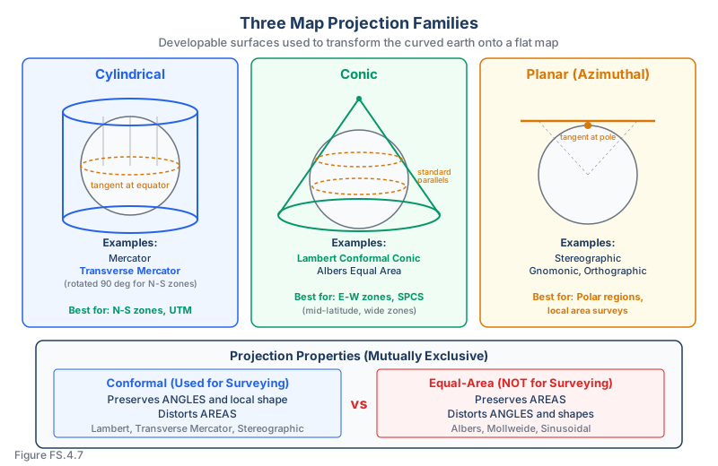
Conformal vs. equal-area: These properties are mutually exclusive. A conformal projection distorts areas; an equal-area projection distorts shapes. Surveying uses conformal projections because preserving angles is critical for bearing measurements.
The Three Projection Families
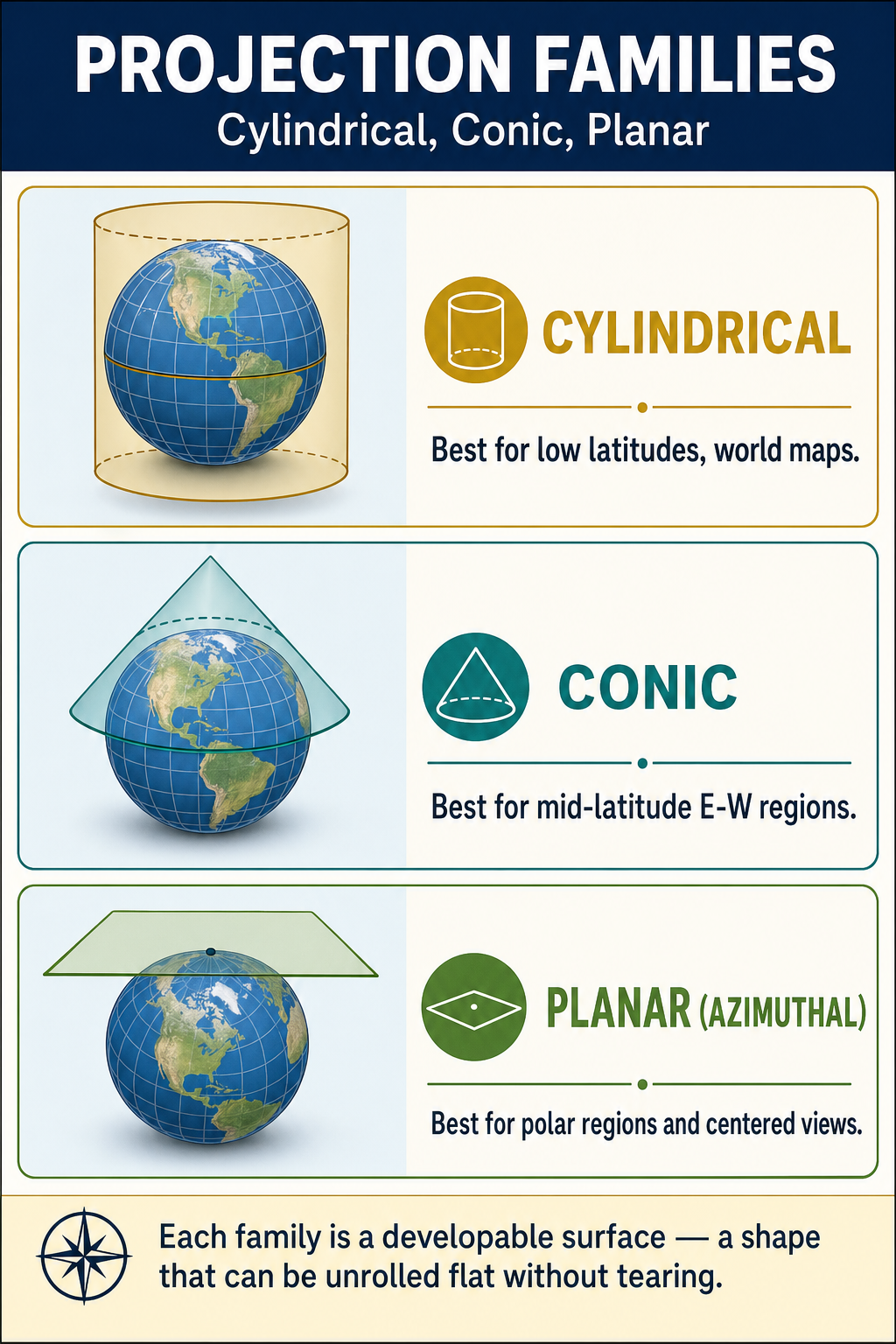
Projections are classified by the developable surface (the geometric shape used to project onto):
Cylindrical projections:
- Project onto a cylinder wrapped around the earth
- Examples: Mercator, Transverse Mercator
- Well-suited for equatorial regions (standard) or north-south zones (transverse)
Conic projections:
- Project onto a cone placed over the earth
- Examples: Lambert Conformal Conic, Albers Equal Area
- Well-suited for mid-latitude regions that extend east-west
Planar (azimuthal) projections:
- Project onto a flat plane tangent to (or secant to) the earth
- Examples: Stereographic, Gnomonic, Orthographic
- Well-suited for polar regions or local areas
Conformal Projections in Surveying
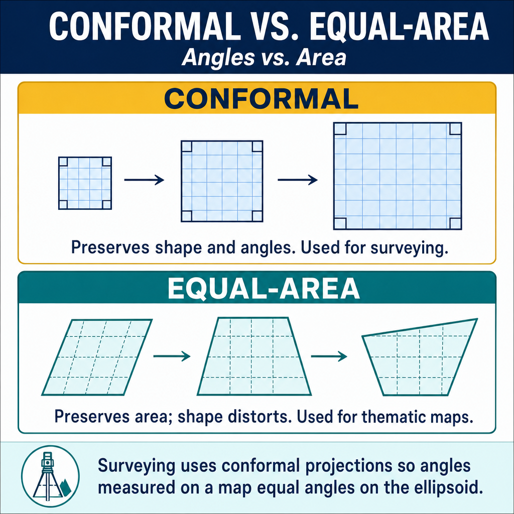
Surveying uses conformal (orthomorphic) projections because they preserve:
- Angles: An angle measured on the ground is the same on the map (critical for bearing measurements)
- Local shape: Small features maintain their correct shape
- Scale uniformity: At any given point, the scale is the same in all directions
The cost: Conformal projections distort areas -- features at different locations on the map may be shown at different scales.
Lambert Conformal Conic Projection
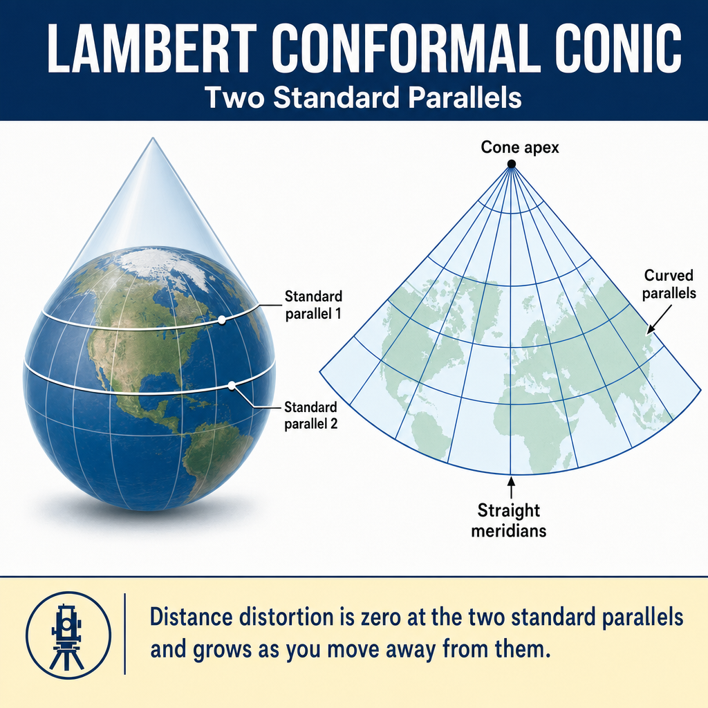
Used for SPCS zones that are wider east-west:
- The cone intersects the ellipsoid along two standard parallels
- Scale factor = 1.0 on the standard parallels
- Scale factor < 1.0 between the parallels; > 1.0 outside them
- Convergence of meridians is represented (grid north converges toward the pole)
- Well-suited for zones spanning 2-3 degrees of latitude
Transverse Mercator Projection
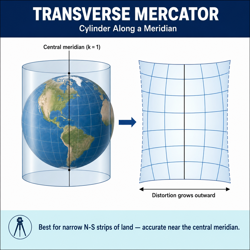
Used for SPCS zones that are longer north-south:
- The cylinder is rotated 90 degrees (axis lies in the equatorial plane)
- Scale factor = 1.0 along two lines parallel to the central meridian (secant cylinder)
- Scale factor is less than 1.0 on the central meridian and increases with distance
- Well-suited for zones spanning 2-3 degrees of longitude
Universal Transverse Mercator (UTM)
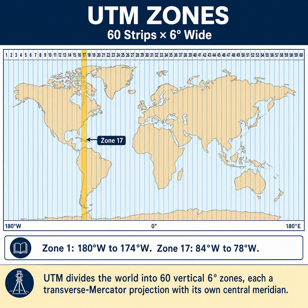
The UTM system divides the earth into 60 zones, each 6 degrees of longitude wide:
Key parameters:
- Zone numbering: 1 through 60, starting at 180 degrees west longitude
- Central meridian scale factor: 0.9996 (the cylinder is secant, reducing distortion across the zone)
- False easting: 500,000 m (at the central meridian, to ensure all eastings are positive)
- False northing: 0 m in the northern hemisphere; 10,000,000 m in the southern hemisphere
- Coverage: 84 degrees N to 80 degrees S latitude (NGA / former DMA UTM definition; Snyder, Map Projections — A Working Manual, USGS Professional Paper 1395 / Bulletin 1532)
UTM zone identification:
- Zone 10: covers 126°W to 120°W (U.S. West Coast)
- Zone 15: covers 96 W to 90 W (includes parts of Texas, Louisiana)
- Zone 17: covers 84 W to 78 W (includes parts of the eastern US)
Common wrong path — using UTM where SPCS is needed. UTM and SPCS are both Transverse Mercator-based (well, SPCS mostly is), but their distortion budgets differ by a factor of 4 or more. UTM's max distortion is ~1:2,500 (400 ppm); SPCS typically holds to ~1:10,000 (100 ppm). For a 2,000-ft lot line, the difference between these two systems is 0.8 ft vs 0.2 ft — the UTM answer is acceptable for GIS and regional mapping but too coarse for boundary surveying or construction stakeout. Exam questions test this by asking "which coordinate system is appropriate for a 1-acre commercial parcel survey" — the answer is SPCS, not UTM. UTM is for regional/international contexts; SPCS is the default for local professional surveying in the U.S.
Quick retrieval check — try before reading on.
▶A 1,200-ft boundary line is staked from UTM coordinates using a central-meridian scale factor of 0.9996. The site is near the zone boundary, where scale factor is approximately 1.0004. If the surveyor neglects to apply any scale correction, how far off will the staked line be compared to ground distance?
Scale factor at the zone boundary is ~1.0004. Ground = Grid / k = 1,200 / 1.0004 = 1,199.52 ft. The surveyor who uses 1,200.00 ft from the grid coordinates directly will overshoot the correct ground position by about 0.48 ft — a significant error for a property corner, large enough to miss an easement or setback check. The lesson: always apply the scale factor (or combined factor, if the project is above sea level) when converting between grid and ground distances. At the UTM zone center, scale factor is 0.9996 (4 ppm below 1.0); at the edges, it rises above 1.0. This is why UTM is not recommended for precise boundary work.
UTM vs. SPCS:
| Feature | UTM | SPCS |
|---|---|---|
| Zone width | 6 degrees longitude | Varies (2-4 degrees) |
| Max distortion | ~1:2,500 (400 ppm) — Snyder, USGS Bulletin 1532 | ~1:10,000 (100 ppm) — NOAA Manual NOS NGS 5 |
| Coverage | Global | United States only |
| Use | Military, international, GIS | Local surveying, engineering |
| Central meridian k | 0.9996 | Varies (typically 0.9999+) |
Map Projection Distortion
Tissot's indicatrix is a theoretical tool for visualizing distortion. At each point on the map, a small circle on the earth is shown as an ellipse on the map. The shape and size of the ellipse reveal:
- Conformal projections: The indicatrix is always a circle (angles preserved), but the circle size varies (area distorted)
- Equal-area projections: The indicatrix has constant area, but the shape changes (angles distorted)
- Equidistant projections: Distances are preserved along specific lines
Commonly Used Projections in Surveying
| Projection | Type | Preserves | Common Use |
|---|---|---|---|
| Lambert Conformal Conic | Conic | Angles, shapes | SPCS (wide zones) |
| Transverse Mercator | Cylindrical | Angles, shapes | SPCS (narrow zones), UTM |
| Mercator | Cylindrical | Angles, shapes | Navigation, web maps |
| Albers Equal Area | Conic | Area | Thematic maps, USGS |
| Stereographic | Planar | Angles, shapes | Polar regions, local surveys |
Exam Tips
- Conformal projections preserve angles and local shapes -- these are used for surveying (Lambert, Transverse Mercator)
- Equal-area projections preserve area but distort shapes -- NOT used for surveying coordinate systems
- A conformal projection and an equal-area projection cannot be the same; the properties are mutually exclusive
- UTM uses Transverse Mercator with a central meridian scale factor of 0.9996 and 60 zones of 6 degrees each
- UTM false easting = 500,000 m; false northing = 0 (north) or 10,000,000 m (south)
- Lambert is for wide (east-west) zones; Transverse Mercator is for narrow (north-south) zones
- UTM has greater distortion than SPCS because UTM zones are wider
- Know the three projection families: cylindrical, conic, planar
- The FS exam may ask which projection preserves a specific property, or which type is used for SPCS/UTM
Related Test Topics
- State Plane Coordinates (Topic 4.6)
- Datums and Conversions (Topic 4.5)
- Geodetic Coordinates and Surfaces (Topic 4.4)
- Map Concepts and Cartography (Module 2, Topic 2.1)
Further Reading
Authoritative sources for deeper study
Snyder, USGS Bulletin 1532 — Map Projections Used by the USGS — Mathematical treatment of common map projections (Lambert Conformal Conic, Transverse Mercator, etc.).
NOAA Manual NOS NGS 5 — State Plane Coordinate System of 1983 — Definitive NGS reference for SPCS83 zone constants, projections, and conversions.
Wolf & Ghilani, Elementary Surveying — Chapter on map projections and the State Plane Coordinate System.
Penn State GEOG 482 — The Nature of Geographic Information — Open courseware on map projections, datums, and geospatial data fundamentals.
Last updated: 2026-04-17