FS Exam Preparation
Comprehensive preparation for the Fundamentals of Surveying (FS) exam. 7 modules covering all 7 exam domains with 60 in-depth topics.
Module 1: Surveying Processes & Methods
Module 2: Mapping Processes & Methods
Module 3: Boundary Law & Real Property
Module 4: Surveying Principles & Geodesy
Module 5: Survey Computations
Module 6: Business Concepts
Field Documentation & Record Keeping
Learning Objectives
After completing this topic, you should be able to:
- Describe the essential elements of proper field notes
- Explain the importance of field documentation as a legal record
- Identify the types of field notes used in surveying
- Describe metadata requirements for electronic data
- Understand quality control procedures for field data
- Apply proper correction methods for field note errors
Overview
Field documentation is the permanent record of surveying observations, procedures, and conditions. Whether recorded in a traditional field book or stored in an electronic data collector, field notes are the foundation upon which all survey computations, maps, and legal opinions are built. Poor documentation can invalidate otherwise good measurements, while thorough documentation protects both the surveyor and the client.
The FS exam tests your understanding of proper documentation practices, including what information must be recorded, how errors should be corrected, and how electronic data should be managed.
Key Concepts
Purpose of Field Documentation
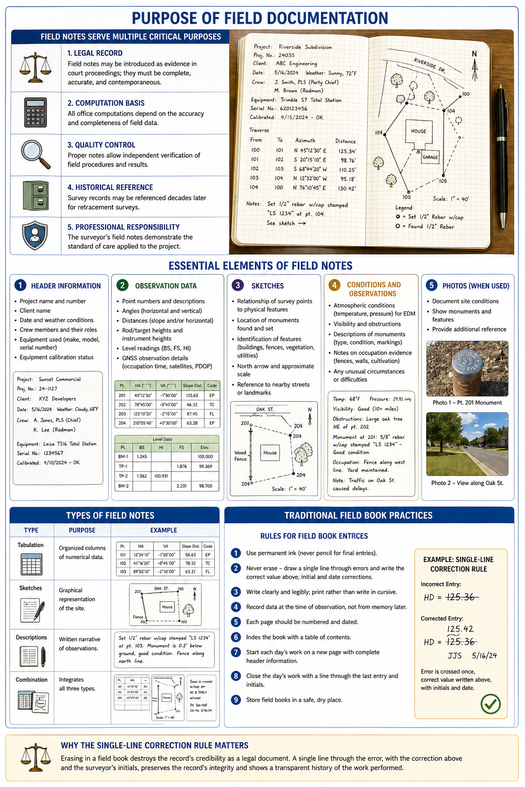
Field notes serve multiple critical purposes:
- Legal record: Field notes may be introduced as evidence in court proceedings; they must be complete, accurate, and contemporaneous
- Computation basis: All office computations depend on the accuracy and completeness of field data
- Quality control: Proper notes allow independent verification of field procedures and results
- Historical reference: Survey records may be referenced decades later for retracement surveys
- Professional responsibility: The surveyor's field notes demonstrate the standard of care applied to the project
Essential Elements of Field Notes
Every set of field notes should include:
Header information:
- Project name and number
- Client name
- Date and weather conditions
- Crew members and their roles
- Equipment used (make, model, serial number)
- Equipment calibration status
Observation data:
- Point numbers and descriptions
- Angles (horizontal and vertical)
- Distances (slope and/or horizontal)
- Rod/target heights and instrument heights
- Level readings (BS, FS, HI) for leveling
- GNSS observation details (occupation time, satellites, PDOP)
Sketches:
- Relationship of survey points to physical features
- Location of monuments found and set
- Identification of features (buildings, fences, vegetation, utilities)
- North arrow and approximate scale
- Reference to nearby streets or landmarks
Conditions and observations:
- Atmospheric conditions (temperature, pressure) for EDM
- Visibility and obstructions
- Descriptions of monuments (type, condition, markings)
- Notes on occupation evidence (fences, walls, cultivation)
- Any unusual circumstances or difficulties
Types of Field Notes
| Type | Purpose | Example |
|---|---|---|
| Tabulation | Organized columns of numerical data | Level notes, traverse angles/distances |
| Sketches | Graphical representation of the site | Topographic details, boundary evidence |
| Descriptions | Written narrative of observations | Monument condition, occupation evidence |
| Combination | Integrates all three types | Most professional field notes |
Traditional Field Book Practices
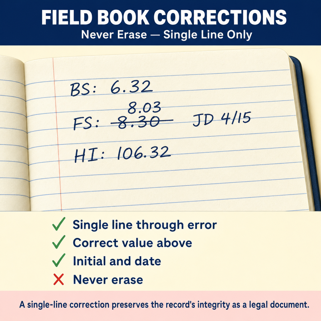
Rules for field book entries:
- Use permanent ink (never pencil for final entries)
- Never erase -- draw a single line through errors and write the correct value above; initial and date corrections
- Write clearly and legibly; print rather than write in cursive
- Record data at the time of observation, not from memory later
- Each page should be numbered and dated
- Index the book with a table of contents
- Start each day's work on a new page with complete header information
The single-line correction rule is critical: erasing in a field book destroys the record's credibility as a legal document. A single line through the error, with the correction above and the surveyor's initials, preserves the record's integrity.
Common wrong path — "fixing" electronic field data after the fact. Electronic data collectors make it tempting to "clean up" raw data before delivering it: delete blundered points, edit feature codes, re-enter a rod height that was wrong, or adjust timestamps. Do NOT modify raw data files. Raw data is the electronic equivalent of the original field book — it must be preserved unaltered as the permanent record of what was observed, not what you wish had been observed. If a point is wrong, note it in the notes and in the processing log, but leave the raw record intact. Make your corrections on a copy or in a separate processing file, and document why. Courts, boards, and auditors all expect raw field data to be preserved in its original form; evidence of post-hoc modification can invalidate the survey and expose the surveyor to discipline. The same rule that forbids erasure in a paper field book forbids editing in raw electronic data — different media, same principle.
Quick retrieval check — try before reading on.
▶Your data collector recorded a point with a rod height error (someone forgot to update from 6.56 ft to 5.45 ft on a height change). You discover this in the office. You know the correct rod height. What should you do with the raw data file?
Leave the raw data file unmodified. The raw data records what the instrument actually observed, including the rod height that was entered at the time. Do not go into the raw file and change 6.56 to 5.45 — even though you know the correct value, altering the raw file destroys its integrity as the permanent field record.
Instead: (1) note the error in a separate processing document or metadata note; (2) in your adjustment software or processing workflow, apply a height correction as a processing step on a copy of the data (most survey software allows this); (3) document the correction — who identified it, when, and the correction applied — so that a reviewer can reconstruct the processing path. The final adjusted coordinates will reflect the correct rod height, but the raw observation data will remain as observed. If a court or licensing board ever asks "what did the instrument actually record?", you can answer accurately — "the recorded rod height was 6.56 ft, which we identified as an error during processing; the corrected value of 5.45 ft was applied in the adjustment." That audit trail is exactly what professional practice expects.
Electronic Data Collection
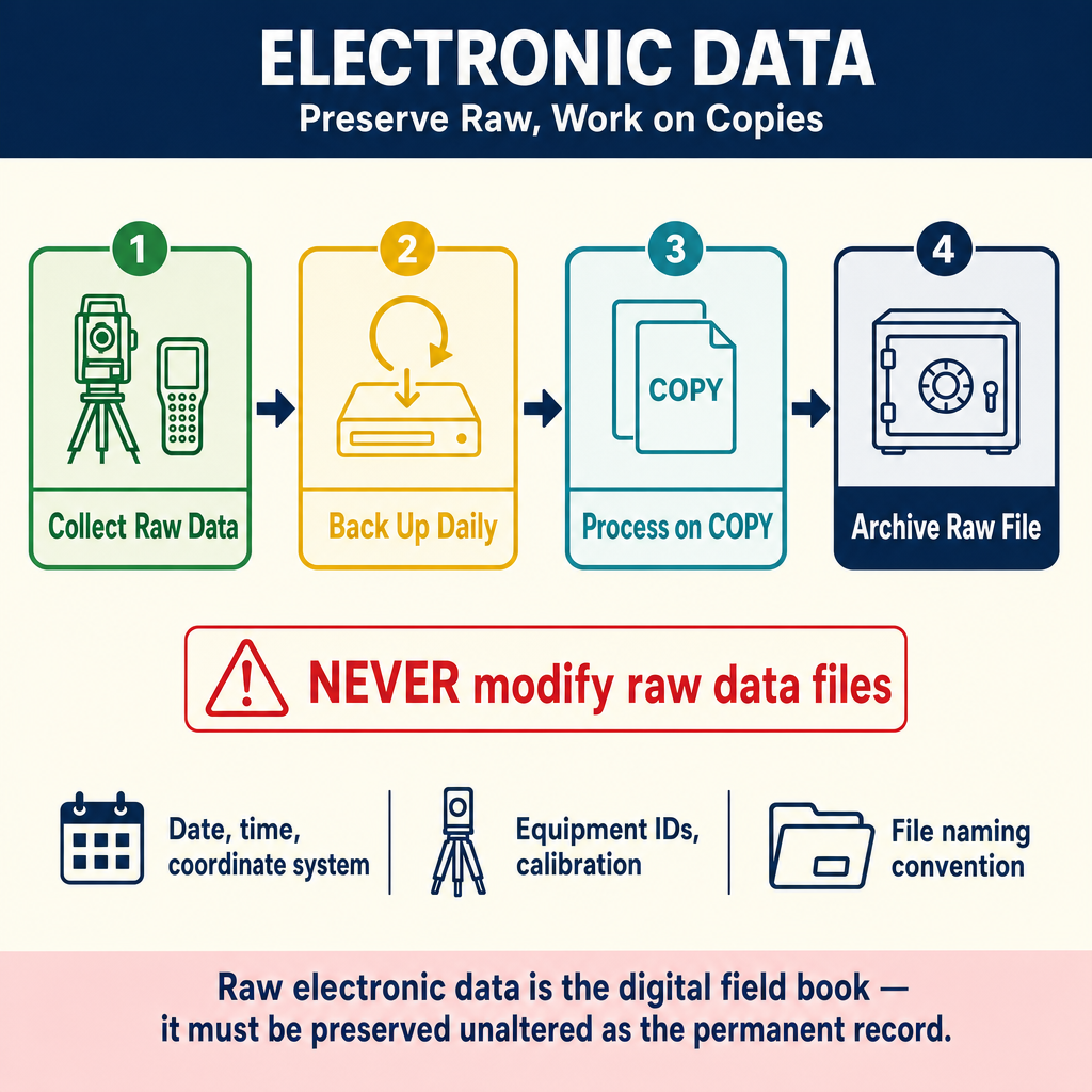
Modern surveys typically use electronic data collectors (field controllers) paired with total stations or GNSS receivers.
Advantages:
- Eliminates transcription errors
- Automatic computation of coordinates
- Feature coding for automated CAD processing
- Large data storage capacity
- Integration with office software
Documentation requirements for electronic data:
- Metadata: Date, time, project name, coordinate system, units, equipment IDs
- Control point documentation: How control was established and verified
- Calibration records: Site calibration parameters, localization residuals
- Backup procedures: Data backed up daily to a separate device
- File naming conventions: Consistent, descriptive file names
- Supplementary notes: Written notes or sketches for information not captured electronically
Quality Control in the Field
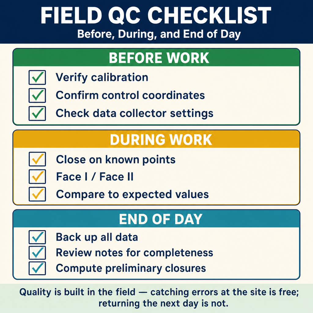
Before starting work:
- Verify instrument calibration (peg test, collimation check, EDM check)
- Confirm control point coordinates and descriptions
- Check that the data collector settings match project requirements (units, coordinate system, geoid model)
During observations:
- Close traverses on known points to check for blunders
- Take redundant measurements (Face I/Face II, multiple GNSS occupations)
- Check level circuits by closing on benchmarks
- Compare measurements to expected values
- Record any anomalies or concerns
End of day:
- Back up all electronic data
- Review field notes for completeness
- Compute preliminary closures
- Note any work remaining for the next day
Data Management
- Raw data preservation: Never modify the original raw data file; always work with copies
- File organization: Maintain a logical folder structure with project number, date, and description
- Version control: Keep track of data processing versions
- Archival: Survey records should be retained for the duration required by state law and professional standards (often 10+ years or permanently for boundary surveys)
Exam Tips
- Field notes are a legal record -- they may be introduced as evidence in court
- Never erase in a field book; use a single line through errors, write the correction above, and initial
- Electronic data must include metadata (date, coordinate system, equipment, calibration)
- Back up electronic data daily -- data loss is a serious professional and legal issue
- Raw data files should never be modified; work with copies
- Field notes should include sketches even when using electronic data collectors
- The FS exam may test proper correction procedures for field note errors
- Quality control includes: redundant measurements, closing on known points, and equipment calibration checks
- Every observation should be recorded at the time it is made, not reconstructed from memory
Related Test Topics
- Total Stations and EDM (Topic 1.1)
- Levels and Instruments (Topic 1.2)
- GNSS/GPS Methods (Topic 1.3)
- Cadastral and Boundary Surveys (Topic 1.6)
Further Reading
Authoritative sources for deeper study
Wolf & Ghilani, Elementary Surveying — An Introduction to Geomatics (13th Ed., 2012) — Comprehensive surveying text covering instruments, field procedures, and computations.
Kavanagh, Surveying with Construction Applications (7th Ed.) — Combined surveying and construction-layout reference.
Model Rules of Professional Conduct (Aug 2025) — Model ethics, competence, and licensure rules adopted by most state boards.
APWA Uniform Color Code — Standard utility-marking colors used in one-call locates.
Last updated: 2026-04-17