FS Exam Preparation
Comprehensive preparation for the Fundamentals of Surveying (FS) exam. 7 modules covering all 7 exam domains with 60 in-depth topics.
Module 1: Surveying Processes & Methods
Module 2: Mapping Processes & Methods
Module 3: Boundary Law & Real Property
Module 4: Surveying Principles & Geodesy
Module 5: Survey Computations
Module 6: Business Concepts
Route Surveying & Alignments
Learning Objectives
After completing this topic, you should be able to:
- Define the elements of a simple horizontal curve
- Calculate horizontal curve elements from given data
- Compute stations of curve points (PC, PT, PI)
- Describe vertical curve geometry and compute elevations on a vertical curve
- Explain the purpose of spiral (transition) curves
- Calculate superelevation and its purpose
Overview
Route surveying involves the design and layout of linear transportation facilities -- roads, highways, railroads, pipelines, and channels. The alignment of these facilities consists of a series of tangent sections connected by horizontal curves (in plan view) and vertical curves (in profile view).
The FS exam heavily tests horizontal and vertical curve computations. You should be comfortable with the standard formulas and able to solve problems quickly.
Key Concepts
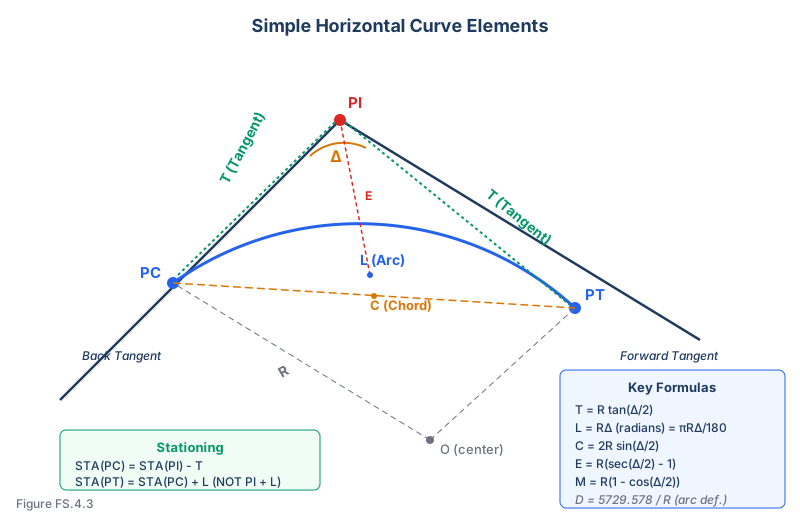
Horizontal Curves: Simple Circular Curves
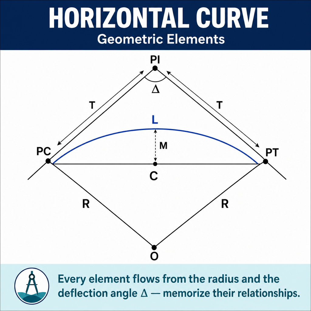
A simple curve is a circular arc that connects two tangent lines. The key elements are:
| Element | Symbol | Definition |
|---|---|---|
| Point of Intersection | PI | Where the two tangent lines meet |
| Point of Curvature | PC | Beginning of the curve (on the back tangent) |
| Point of Tangency | PT | End of the curve (on the forward tangent) |
| Radius | R | Radius of the circular curve |
| Deflection Angle | Delta / I | The angle between the two tangent lines |
| Tangent Length | T | Distance from PC to PI (or PI to PT) |
| Curve Length | L | Length of the arc from PC to PT |
| Chord Length | C | Straight-line distance from PC to PT |
| External Distance | E | Distance from PI to the midpoint of the curve |
| Middle Ordinate | M | Distance from the midpoint of the chord to the midpoint of the curve |
Horizontal Curve Formulas
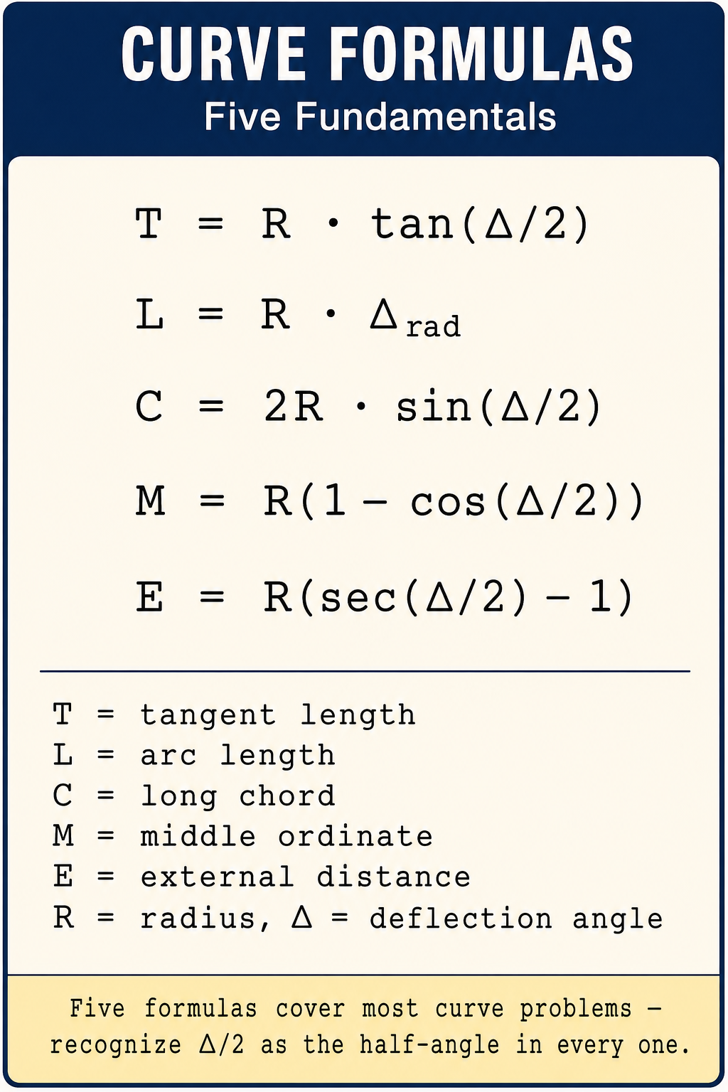
Degree of Curve
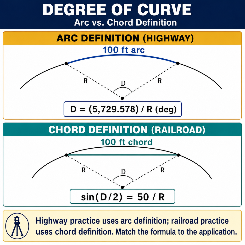
Two definitions exist:
Arc definition (highway/road):
This is the central angle subtended by a 100-foot arc. Used for highways in the U.S.
Chord definition (railroad):
This is the central angle subtended by a 100-foot chord. Used for railroads. For small D (roughly D < 2°), the chord and arc definitions agree to within ~1 ppm, but they diverge for sharper curves.
For the FS exam, the arc definition is more common.
Stationing
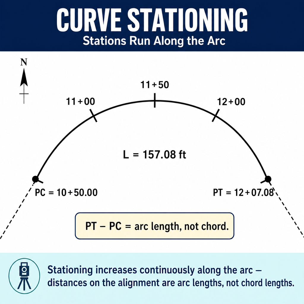
Stations measure distance along the centerline:
Important: The station of PT is computed by adding the arc length L to the PC station, NOT by adding L to the PI station.
Example: PI is at station 25+00. The deflection angle is 30 degrees, and R = 1000 ft.
Vertical Curves
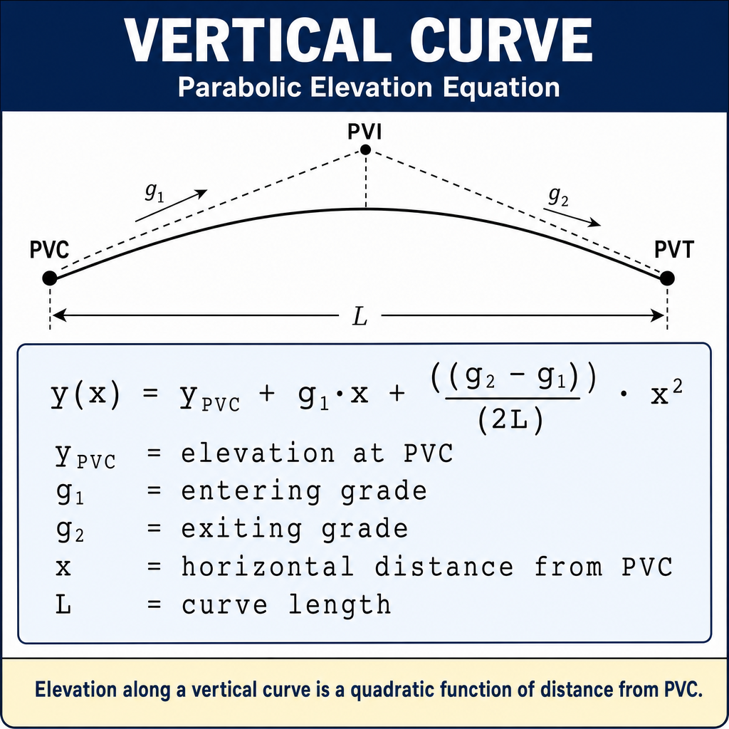
Vertical curves are parabolic arcs connecting two tangent grades. They provide smooth transitions for vehicles and ensure adequate sight distance and drainage.
Types:
- Crest curve: The grade decreases (going over a hill)
- Sag curve: The grade increases (going through a valley)
Key parameters:
- PVC: Point of Vertical Curvature (beginning)
- PVI: Point of Vertical Intersection (where tangent grades meet)
- PVT: Point of Vertical Tangency (end)
- L: Length of the vertical curve
- g1, g2: Incoming and outgoing grades (as decimals or percentages)
Elevation on a vertical curve:
Where x is the distance from the PVC and grades are expressed as decimals (e.g., +3% = 0.03).
High/low point location (for drainage or sight distance):
This gives the distance from the PVC to the high point (crest curve) or low point (sag curve).
Example: A 400-ft crest curve connects a +3% grade to a -2% grade. PVC elevation = 520.00 ft at station 10+00.
At station 12+00 (x = 200 ft):
High point: ft from PVC.
Spiral (Transition) Curves
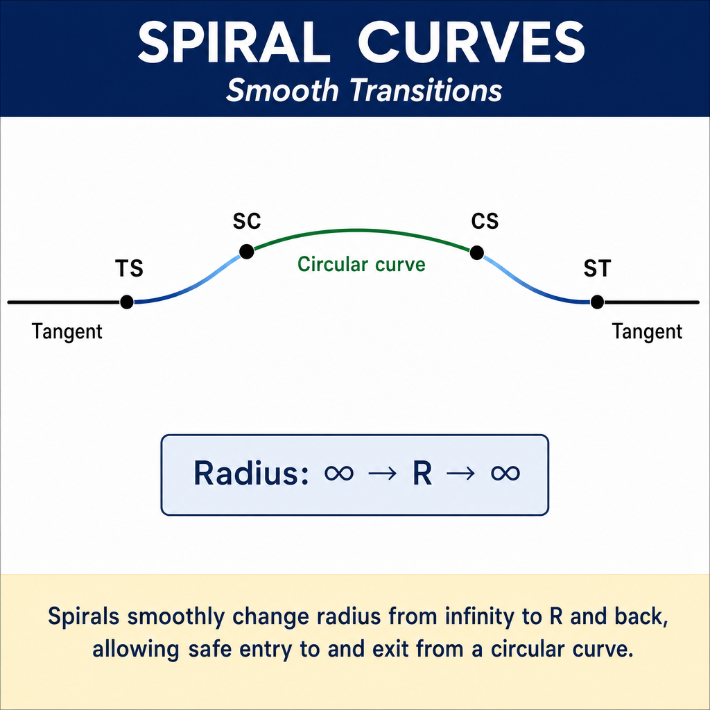
Spiral curves provide a gradual transition from a tangent (infinite radius) to a circular curve (fixed radius). The radius of a spiral varies continuously along its length.
Purpose:
- Smooth transition of centripetal acceleration for vehicles
- Gradual introduction of superelevation
- Improved rider comfort and safety
The Euler spiral (clothoid) is the most common type, defined by the property that the radius varies inversely with the distance along the spiral (Kavanagh, Surveying with Construction Applications, 7th Ed., Ch. 11; AASHTO A Policy on Geometric Design of Highways and Streets ("Green Book")).
Common wrong path — spiral layout formulas vs. simple curve formulas. Spiral curves have their own set of formulas and should not be computed with simple-curve formulas (T = R tan(Δ/2), L = R·Δ, etc.). When a highway plan shows TS, SC, CS, ST (tangent-to-spiral, spiral-to-curve, curve-to-spiral, spiral-to-tangent), you are looking at spiraled transitions — not a simple circular curve. Students sometimes take the central angle of the combined spiral-circular-spiral layout and apply R·Δ, producing a total arc length that's wrong. The spiral "consumes" part of the deflection angle at each end of the circular portion; the circular portion itself has a smaller central angle than the total PI deflection. Always check the alignment type before applying formulas: if any spiral transitions are present, use Hickerson's tables or the clothoid formulas, not the simple-curve equations.
Quick retrieval check — try before reading on.
▶A horizontal alignment has PI deflection Δ = 24° with spiral transitions at both ends. Each spiral is 100 ft long and "consumes" a central angle θs of 2°. The circular portion has R = 1,500 ft. What is the arc length of the circular portion?
Central angle of the circular portion = Δ − 2·θs = 24° − (2 × 2°) = 20°.
Arc length of the circular portion = ft.
If you had applied R·Δ to the full 24° (treating this as a simple curve), you'd get ft — about 105 ft too long. That error accumulates in stationing of subsequent alignment points. The total alignment length includes both spirals plus the circular arc: 100 + 523.6 + 100 = 723.6 ft between TS and ST.
Superelevation
Superelevation is the banking (tilting) of the roadway on a horizontal curve to counteract centrifugal force.
Where e is the superelevation rate (ft/ft or m/m), f is the side friction factor, V is the design speed, g is gravitational acceleration, and R is the curve radius. This dimensional form requires consistent SI units (V in m/s, g in m/s², R in m).
In practical engineering use (Kavanagh §11 / AASHTO Green Book), g is folded into the constant after a unit conversion, giving the more commonly tabulated forms:
In practice, maximum superelevation rates are typically 4% to 8% for highways.
Exam Tips
- T = R x tan(Delta/2) -- this is the most-used horizontal curve formula
- STA_PC = STA_PI - T and STA_PT = STA_PC + L -- do NOT add L to PI
- For vertical curves: -- use consistent units (grades as decimals)
- The high/low point of a vertical curve is at from the PVC
- The arc definition of degree of curve is used for highways:
- A larger radius means a gentler (flatter) curve; a smaller radius means a sharper curve
- Crest curves affect stopping sight distance; sag curves affect headlight sight distance
- The FS exam typically gives you two or three curve parameters and asks you to compute others
- Practice these calculations until they are fast and reliable -- they appear on nearly every FS exam
Related Test Topics
- Plan and Profile Drawings (Module 2, Topic 2.2)
- Construction Surveys and Staking (Module 1, Topic 1.8)
- Horizontal Surveys and Methods (Topic 4.1)
- Vertical Surveys and Leveling (Topic 4.2)
Further Reading
Authoritative sources for deeper study
Kavanagh, Surveying with Construction Applications (7th Ed.) — Combined surveying and construction-layout reference.
Wolf & Ghilani, Elementary Surveying — Chapters on horizontal and vertical curve computations.
MUTCD 2023 Part 6 — Temporary Traffic Control — Federal standard for work-zone traffic control devices and surveyor safety.
Last updated: 2026-04-17