FS Exam Preparation
Comprehensive preparation for the Fundamentals of Surveying (FS) exam. 7 modules covering all 7 exam domains with 60 in-depth topics.
Module 1: Surveying Processes & Methods
Module 2: Mapping Processes & Methods
Module 3: Boundary Law & Real Property
Module 4: Surveying Principles & Geodesy
Module 5: Survey Computations
Module 6: Business Concepts
Geodetic Coordinates & Surfaces
Learning Objectives
After completing this topic, you should be able to:
- Define the geoid, ellipsoid, and topographic surface
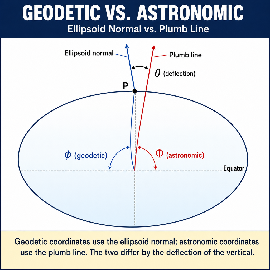
- Distinguish between geodetic and astronomic coordinates
- Explain why different reference surfaces are used in surveying
- Describe the parameters that define a reference ellipsoid
- Understand the deflection of the vertical
- Relate the three fundamental surfaces to each other
Overview
Surveying operates on a curved earth, and accurately representing positions requires understanding the mathematical surfaces used as references. The three fundamental surfaces in geodesy are the topographic surface (the actual earth), the geoid (a gravity-based equipotential surface), and the ellipsoid (a mathematical approximation of the earth's shape).
The FS exam tests your understanding of these surfaces and how they relate to coordinate systems and measurement methods.
Key Concepts
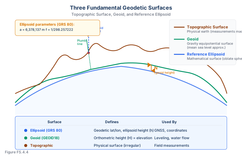
The Three Fundamental Surfaces
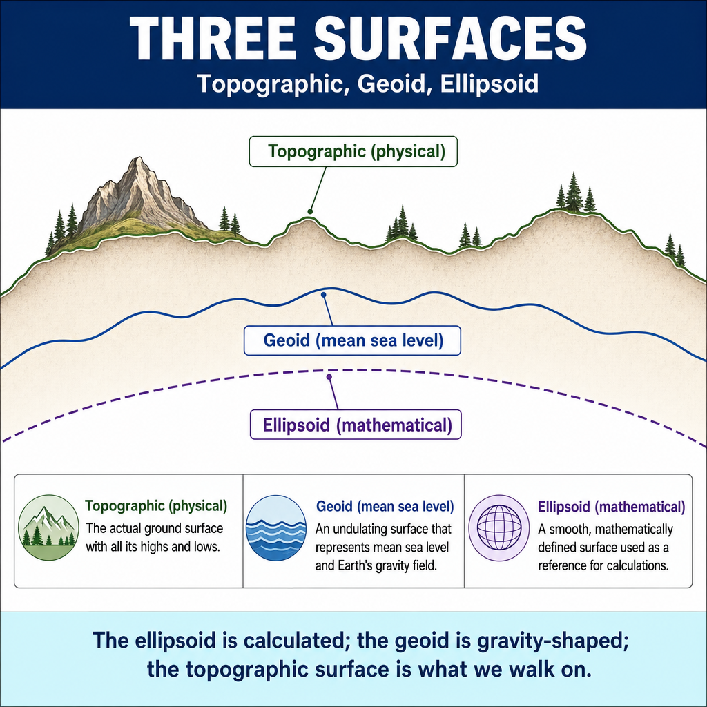
1. Topographic surface:
- The actual physical surface of the earth including mountains, valleys, oceans
- Where measurements are actually made
- Irregular and complex -- not suitable as a mathematical reference
2. Geoid:
- An equipotential gravity surface that approximates mean sea level
- The surface that water would assume if the oceans were extended through the continents via canals, subject only to gravity
- Everywhere perpendicular to the direction of gravity (a plumb line)
- Defines orthometric height (what surveyors call "elevation")
- Irregular surface influenced by the distribution of mass within the earth
- Cannot be described by a simple mathematical formula -- must be modeled (e.g., GEOID18)
3. Reference ellipsoid:
- A mathematically defined surface (an oblate spheroid) that approximates the shape of the earth
- Defined by two parameters: semi-major axis (a) and flattening (f)
- Smooth, regular, and mathematically tractable
- Used as the reference for geodetic coordinates (latitude, longitude, ellipsoid height)
- Different datums use different ellipsoids (GRS 80 for NAD 83; Clarke 1866 for NAD 27; WGS 84 ellipsoid for GPS)
Ellipsoid Parameters
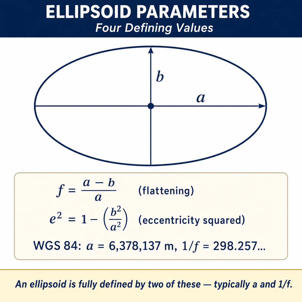
| Parameter | GRS 80 / NAD 83 | WGS 84 | Clarke 1866 / NAD 27 |
|---|---|---|---|
| Semi-major axis (a) | 6,378,137.0 m | 6,378,137.0 m | 6,378,206.4 m |
| Semi-minor axis (b) | 6,356,752.3 m | 6,356,752.3 m | 6,356,583.8 m |
| Flattening (f) | 1/298.257222101 | 1/298.257223563 | 1/294.978698 |
Note: GRS 80 and WGS 84 are practically identical (the difference in flattening is in the 8th decimal place). Clarke 1866 is noticeably different, which is why NAD 27 and NAD 83 coordinates differ.
Geodetic vs. Astronomic Coordinates
Geodetic coordinates:
- Latitude and longitude defined relative to the ellipsoid
- The geodetic latitude is the angle between the ellipsoid normal and the equatorial plane
- The geodetic longitude is the angle between the prime meridian plane and the meridian plane of the point
- Used in GNSS and modern coordinate systems
Astronomic coordinates:
- Latitude and longitude defined by the direction of gravity (the plumb line)
- Determined by observing celestial bodies (stars)
- Referenced to the geoid, not the ellipsoid
- Historically used before GNSS; now less common
Deflection of the Vertical
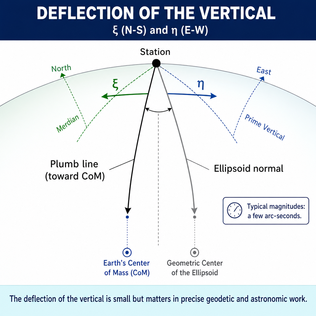
The deflection of the vertical is the angle between the plumb line direction (perpendicular to the geoid) and the ellipsoid normal (perpendicular to the ellipsoid) at a point.
Why it matters:
- Astronomic coordinates differ from geodetic coordinates by the deflection of the vertical
- In areas with significant deflection (near mountains, ocean trenches), astronomic observations cannot be directly used as geodetic coordinates
- Typical magnitude: a few arc seconds to tens of arc seconds
- Large deflections can affect precise leveling and alignment surveys
Components:
- xi (meridian component): Difference in latitude (astronomic minus geodetic)
- eta (prime vertical component): Difference in longitude (astronomic minus geodetic) multiplied by cos(latitude)
Relationship Between Surfaces
The three surfaces have the following relationships:
- The ellipsoid is a smooth mathematical surface; the geoid is an irregular physical surface
- The geoid height (N) or geoid undulation is the separation between the geoid and the ellipsoid: positive when the geoid is above the ellipsoid, negative when below
- In the conterminous United States (using NAD 83/GRS 80), the geoid is approximately 8 to 53 meters below the ellipsoid (N is negative) (NGS GEOID18 model documentation, ngs.noaa.gov)
- The topographic surface is above both the geoid and ellipsoid (except at ocean surfaces, where it approximates the geoid)
Common wrong path — confusing plumb line direction with ellipsoid normal. A plumb line (a weight on a string) points along the direction of gravity, which is perpendicular to the geoid, not to the ellipsoid. The ellipsoid is a purely mathematical surface with its own "normal" direction, which is perpendicular to the ellipsoid itself. At most points on Earth, these two directions are close but not identical — the angular difference is the deflection of the vertical. Students sometimes assume a plumb line is perpendicular to the ellipsoid (so that astronomic = geodetic latitudes), but this is only approximately true. In areas with significant mass anomalies (mountain ranges, ocean trenches), the deflection can be tens of arc seconds, producing real position differences between astronomic-based and geodetic-based coordinates. Exam questions test this by asking what a plumb line is perpendicular to; the answer is the geoid (gravity equipotential surface), not the ellipsoid.
Quick retrieval check — try before reading on.
▶At a point in a major mountain range, the deflection of the vertical has a meridian component of 10 arc seconds and a prime vertical component of 5 arc seconds. If the astronomic latitude is 38° 00' 30", what is the geodetic latitude?
The deflection of the vertical component in the meridian direction (ξ) is defined as astronomic latitude minus geodetic latitude. So:
Geodetic latitude = Astronomic latitude − ξ = 38° 00' 30" − 10" = 38° 00' 20".
Over the distance corresponding to 10 arc seconds of latitude (approximately 1,852 m × 10/60 = 309 m), this is a substantial position difference — far beyond survey-grade tolerances. A surveyor who assumed astronomic = geodetic would position the monument about 309 m south of the correct geodetic position, or 10 arc seconds away, which translates to about 1,000 ft of positioning error at this latitude. The deflection of the vertical is why astronomic observations cannot substitute for geodetic observations in precise work without correction, particularly in mountainous areas or near ocean trenches where gravity anomalies are largest.
Practical Implications for Surveying
Leveling (differential):
- Measures orthometric height differences (referenced to the geoid)
- The level instrument follows a surface perpendicular to gravity
- Elevation is height above the geoid
GNSS:
- Measures positions relative to the ellipsoid
- Gives ellipsoid height directly
- Orthometric height must be computed using a geoid model: H = h - N
Total station / EDM:
- Measures distances along the topographic surface
- Horizontal distances must be reduced to the ellipsoid or projection surface for coordinate computation
Exam Tips
- The geoid is a gravity surface (equipotential); the ellipsoid is a mathematical surface (oblate spheroid)
- The geoid defines orthometric height (elevation); the ellipsoid defines geodetic latitude and longitude
- H = h - N (orthometric height = ellipsoid height minus geoid height)
- In the conterminous U.S., the geoid is below the ellipsoid, so N is negative
- GRS 80 and WGS 84 ellipsoids are practically identical; Clarke 1866 (NAD 27) is different
- The deflection of the vertical causes astronomic and geodetic coordinates to differ
- An ellipsoid is defined by its semi-major axis (a) and flattening (f)
- The FS exam may ask about the relationship between the three surfaces or the meaning of geoid height
- A plumb line points perpendicular to the geoid, not the ellipsoid
Related Test Topics
- Datums and Conversions (Topic 4.5)
- Vertical Surveys and Leveling (Topic 4.2)
- GNSS/GPS Methods (Module 1, Topic 1.3)
- State Plane Coordinates (Topic 4.6)
Further Reading
Authoritative sources for deeper study
NGS Geodetic Glossary (1986, NOAA repository) — Authoritative definitions for geodetic, GNSS, and surveying terms.
Wolf & Ghilani, Elementary Surveying — An Introduction to Geomatics (13th Ed., 2012) — Comprehensive surveying text covering instruments, field procedures, and computations.
NOAA Manual NOS NGS 5 — State Plane Coordinate System of 1983 — Definitive NGS reference for SPCS83 zone constants, projections, and conversions.
Last updated: 2026-04-17