FS Exam Preparation
Comprehensive preparation for the Fundamentals of Surveying (FS) exam. 7 modules covering all 7 exam domains with 60 in-depth topics.
Module 1: Surveying Processes & Methods
Module 2: Mapping Processes & Methods
Module 3: Boundary Law & Real Property
Module 4: Surveying Principles & Geodesy
Module 5: Survey Computations
Module 6: Business Concepts
Supervision & Personnel Management
Learning Objectives
After completing this topic, you should be able to:
- Describe the surveyor's supervisory responsibilities
- Explain the difference between responsible charge and direct supervision
- Identify the roles within a survey crew
- Describe training and competency requirements
- Explain delegation limits for licensed and unlicensed personnel
Overview
Supervision and personnel management are core responsibilities of the licensed professional surveyor. The licensed surveyor bears ultimate responsibility for the accuracy and correctness of the survey, regardless of who performs the individual tasks. The FS exam tests your understanding of how supervision works, who can do what, and where the boundaries of delegation lie.
Key Concepts
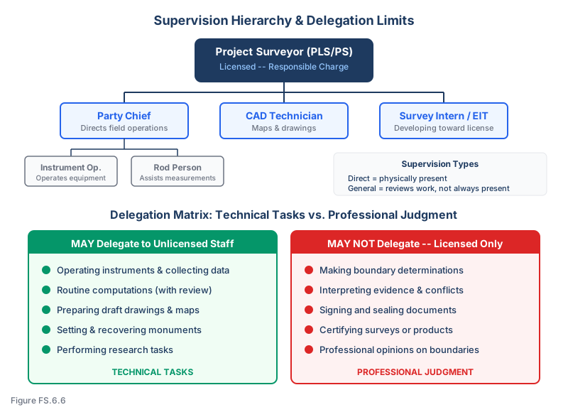
Responsible Charge
Responsible charge means the licensed surveyor exercises independent control and direction of the survey work. The surveyor in responsible charge:
- Makes or approves all professional decisions
- Reviews and accepts all work performed by subordinates
- Is personally accountable for the accuracy and correctness of the survey
- Signs and seals the final work product
Responsible charge does NOT require the surveyor to be physically present at all times in the field. It requires active engagement in the project through:
- Establishing procedures and standards for the crew
- Reviewing field data and computations
- Making judgment calls on boundary evidence and survey decisions
- Being available for consultation during fieldwork
- Personally reviewing the final product before signing and sealing
Direct Supervision vs. General Supervision
| Level | Description | When Required |
|---|---|---|
| Direct supervision | The supervisor is physically present and actively observing the work | New or inexperienced personnel; complex or critical operations |
| General supervision | The supervisor provides instructions and reviews the work but is not always present | Experienced personnel performing routine tasks |
| Responsible charge | The licensed surveyor has overall control and responsibility for the project | All survey projects that will be signed and sealed |
Survey Crew Roles
| Role | Responsibilities | License Required? |
|---|---|---|
| Project surveyor | Overall responsibility; signs and seals; makes professional decisions | Yes (PLS/PS) |
| Party chief / crew chief | Directs field operations; makes field decisions; ensures data quality | Not required, but often licensed or license-eligible |
| Instrument operator | Operates total station, GNSS, level; records observations | No |
| Rod person | Holds prism rod, level rod; assists with measurements | No |
| CAD technician | Prepares maps, plats, and drawings from survey data | No |
| Survey intern / SIT (LSIT) | Developing skills toward licensure; works under supervision | No (holds FS-pass / SIT/LSIT certificate where issued by the state) |
Training Requirements
Competency-based training should address:
- Equipment operation: Proper use and care of survey instruments
- Field procedures: Observation methods, recording standards, quality checks
- Safety: Hazard recognition, PPE use, emergency procedures
- Mathematics: Basic computation skills needed for field checks
- Professional conduct: Ethical behavior, client interaction, confidentiality
- Legal requirements: What unlicensed personnel may and may not do
Delegation Limits
The licensed surveyor may delegate technical tasks but NOT professional judgment:
May be delegated to unlicensed personnel:
- Operating instruments and collecting measurements
- Performing routine computations (with review)
- Preparing draft drawings and maps
- Setting and recovering monuments (under direction)
- Performing research tasks
May NOT be delegated to unlicensed personnel:
- Making boundary determinations
- Interpreting evidence and resolving conflicts
- Signing and sealing survey documents
- Certifying surveys or survey products
- Making professional opinions about property boundaries
Common wrong path — letting the crew chief "make the call" in the field. The crew chief has been doing boundary work for 20 years and is unquestionably competent. The crew reaches a corner where two plausible monuments exist and asks the licensed surveyor for direction. Tempted by the chief's experience and the surveyor's calendar, the surveyor says, "You've got it — use your judgment, whatever you think is right." That answer delegates professional judgment, which is precisely the thing that cannot be delegated to unlicensed personnel. The experienced chief may in fact arrive at the same answer the licensed surveyor would, but the legal responsibility — the signed, sealed opinion — rests on the license-holder, who is required by the state practice act to exercise the judgment, not merely to rubber-stamp it. "Responsible charge" does not mean physical presence, but it does mean active engagement: the surveyor takes the call, reviews the photos, looks at the deed, asks questions, and decides. Students pick the "trust the experienced chief" answer because it respects the chief's skill; the correct answer respects the licensure boundary. Technical tasks delegate freely — professional judgment does not.
Quick retrieval check — try before reading on.
▶Your senior crew chief (unlicensed, 25 years of experience) calls from the field: they have found two iron pipes 2.4 feet apart at what should be the NE corner. One has a cap reading "LS 1234" matching the record. The other is uncapped. The chief says, "I'm going to hold the capped one and move on — okay with you?" You are under a tight deadline. What is the correct professional response, and what is the response if you say "yes, go ahead"?
Correct response: Ask the chief to photograph both pipes (with scale, location shot, close-up of the cap), record the description of each in the field book, and continue with other portions of the survey that do not depend on that corner. Then you personally — even if remotely — review the photos, pull up the record plat and the LS 1234 record of survey, compare the geometry from adjacent monuments, and make the decision about which monument to hold. Communicate the decision back to the chief with a brief reasoning. Document the decision in the project file.
Why "yes, go ahead" is wrong: That answer delegates the boundary determination — which the chief identified is not a ministerial task (if both monuments are equally "called for and identifiable," resolving which one is undisturbed requires judgment). Even if the chief's instinct is correct (the capped LS 1234 monument is almost certainly the right one), the license-holder has not exercised professional judgment — they have deferred it. In a later boundary dispute, a deposition question like "Who decided which monument to hold?" is answered "the unlicensed crew chief," which is both a practice-act violation in most states and a fact pattern that defeats the "responsible charge" defense on liability.
Nuance: The rule is not that the surveyor must make every field call in real time. Many routine calls — "the rebar with the LS 1234 cap is clearly the called monument, and the nail is extraneous" — are so obviously correct that a competent chief making them is simply applying standard practice, not exercising independent professional judgment. But the moment the chief says "two plausible candidates, which one do you want me to hold," they have escalated the decision to the licensee; at that point the licensee must decide, not re-delegate. "Use your judgment" is the exact phrasing that gets licenses suspended and liability verdicts entered.
Licensure Requirements
Every state writes its own licensing statute, but most are modeled on the Model Law — the framework drafted and maintained by NCEES that proposes minimum requirements for education, experience, and examination across the U.S. The Model Law is not binding on any state, but it is the closest thing to a national licensure framework and is the structure tested on the FS exam (companion to the Model Rules of Professional Conduct, which governs ethics).
The path to professional licensure typically requires:
- Education: Accredited degree in surveying or related field (varies by state)
- Fundamentals exam: Pass the FS (Fundamentals of Surveying) exam
- Experience: Typically 4 years of progressive experience under a licensed surveyor
- Principles and Practice exam: Pass the PS exam (and state-specific exam if required)
- Application: Submit to the state licensing board
Exam Tips
- Responsible charge is the key concept -- the licensed surveyor is accountable even when not physically present
- Unlicensed personnel can collect data but cannot make professional judgments about boundaries
- The surveyor who signs and seals the work is responsible, even if someone else collected the data
- Direct supervision requires physical presence; general supervision does not
- Training is the employer's responsibility; sending untrained crews to the field is both a safety and liability problem
- The FS exam may present scenarios where delegation goes too far -- identify when professional judgment is being improperly delegated
- Every state has its own licensing laws, but the Model Law provides the general framework tested on the FS exam
Related Test Topics
- Professional Ethics (Topic 6.7)
- Liability and Insurance (Topic 6.4)
- Safety Procedures and Equipment (Topic 6.3)
- Project Planning and Resources (Topic 6.1)
Further Reading
Authoritative sources for deeper study
Model Rules of Professional Conduct (Aug 2025) — Model ethics, competence, and licensure rules adopted by most state boards.
Kavanagh, Surveying with Construction Applications (7th Ed.) — Combined surveying and construction-layout reference.
Last updated: 2026-04-17