FS Exam Preparation
Comprehensive preparation for the Fundamentals of Surveying (FS) exam. 7 modules covering all 7 exam domains with 60 in-depth topics.
Module 1: Surveying Processes & Methods
Module 2: Mapping Processes & Methods
Module 3: Boundary Law & Real Property
Module 4: Surveying Principles & Geodesy
Module 5: Survey Computations
Module 6: Business Concepts
Coordinate Geometry (COGO)
Learning Objectives
After completing this topic, you should be able to:
- Compute the distance and azimuth between two coordinate pairs (inversing)
- Convert between bearings and azimuths
- Perform coordinate translations and rotations
- Solve line-line, line-circle, and circle-circle intersections
- Apply coordinate geometry to practical surveying problems
Overview
Coordinate geometry (COGO) is the mathematical foundation for computing positions, distances, and directions from coordinate values. Every modern survey relies on coordinate-based computations, whether working in a local assumed system, state plane coordinates, or global coordinates. The FS exam tests your ability to perform these calculations accurately using fundamental trigonometric relationships.
Key Concepts
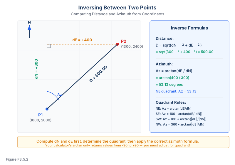
Inversing Between Two Points
Given two points P1(N1, E1) and P2(N2, E2), the inverse computes the distance and direction between them.
Distance:
D = sqrt((N2 - N1)^2 + (E2 - E1)^2)
Azimuth (from north, clockwise):
Compute the reference angle on absolute values so it is always in [0, 90 degrees]:
theta = arctan(|dE| / |dN|)
Then apply the quadrant correction based on the signs of dN and dE:
- NE quadrant (dN > 0, dE > 0): Az = theta
- SE quadrant (dN < 0, dE > 0): Az = 180 - theta
- SW quadrant (dN < 0, dE < 0): Az = 180 + theta
- NW quadrant (dN > 0, dE < 0): Az = 360 - theta
(Software function atan2(dE, dN) returns the azimuth directly, no table required. The convention above matches the inverse-azimuth tables used elsewhere in this course.)
Bearing vs. Azimuth Conversion
- Azimuth: Measured clockwise from north, 0 to 360 degrees
- Bearing: Measured from north or south toward east or west, 0 to 90 degrees
| Azimuth Range | Bearing Quadrant | Conversion |
|---|---|---|
| 0 - 90 | N __ E | Bearing = Azimuth |
| 90 - 180 | S __ E | Bearing = 180 - Azimuth |
| 180 - 270 | S __ W | Bearing = Azimuth - 180 |
| 270 - 360 | N __ W | Bearing = 360 - Azimuth |
Coordinate Translations
A translation shifts all points by the same amount without changing angles or distances:
- N' = N + dN
- E' = E + dE
This is used when converting between local and grid coordinate systems or when relocating a coordinate origin.
Coordinate Rotations
A rotation turns the coordinate system about a fixed point by angle theta:
- N' = N * cos(theta) - E * sin(theta)
- E' = N * sin(theta) + E * cos(theta)
Rotations are necessary when aligning a local survey to a grid system or when reconciling surveys performed on different reference directions.
Line-Line Intersection
Given two lines defined by points and azimuths, the intersection point can be found by solving two parametric equations simultaneously. If line 1 passes through P1 with azimuth Az1 and line 2 passes through P2 with azimuth Az2:
- N = N1 + d1 * cos(Az1) = N2 + d2 * cos(Az2)
- E = E1 + d1 * sin(Az1) = E2 + d2 * sin(Az2)
Solve for d1 (or d2), then compute the intersection coordinates.
Common wrong path — wrong arctan axis (swapping dE and dN). For a surveying azimuth (clockwise from north), the formula is — departure over latitude. Students frequently swap this to , which gives the angle measured from east (a standard math-class angle), not from north. The swap produces answers that are reflected across the 45° line, so a true azimuth of 30° comes out as 60°. Exam questions bait this error by phrasing the question in ways that invite "rise over run" instinct — remember: for azimuths, it's always east over north (ΔE over ΔN). The same relationship lives in the lat/dep equations: Latitude uses cos(Az), Departure uses sin(Az). Sin and opposite (ΔE) go together.
Quick retrieval check — try before reading on.
▶Point A is at (N=5,000.00, E=10,000.00). Point B is at (N=4,820.50, E=10,325.70). What is the azimuth from A to B?
(south), (east).
Signs: ΔN < 0, ΔE > 0 → SE quadrant (II).
.
Apply the SE-quadrant adjustment: (or S 61.14° E as a bearing).
Quick check: if you had swapped and used , you'd get garbage without clear quadrant logic. Always: (1) compute ΔN and ΔE with signs, (2) determine quadrant from signs, (3) apply arctan(|ΔE|/|ΔN|) for the reference angle, (4) apply the quadrant formula to get the final azimuth.
Computing Coordinates from Bearing and Distance
Given a starting point and a direction/distance:
- N2 = N1 + D * cos(Az)
- E2 = E1 + D * sin(Az)
This is called radiating or computing a traverse leg.
FS Problem Workflow
Most coordinate geometry misses are setup errors, not hard math errors. Use this workflow on every inverse or traverse-leg problem:
- Write coordinates in N/E order. The FS exam may give coordinate pairs in a table, a sketch, or a sentence. Label northing and easting before touching the calculator.
- Compute signed differences. Use Delta N = N2 - N1 and Delta E = E2 - E1. The signs identify the quadrant.
- Choose the direction convention. Survey azimuths are measured clockwise from north; standard math angles are measured counterclockwise from east. Do not mix them.
- Calculate the reference angle. For surveying azimuths, use arctan(|Delta E| / |Delta N|).
- Apply the quadrant rule. The calculator's arctan answer is not the final azimuth unless the line is in the NE quadrant.
- Check reasonableness. If Delta N is negative and Delta E is positive, the answer must be between 90 degrees and 180 degrees.
For forward calculations, reverse the workflow: convert the bearing to azimuth first, compute latitude with cosine, compute departure with sine, then apply signs through the azimuth.
High-Yield Mini Drill
Start at Point 1: N = 2,000.00, E = 5,000.00. Run a line 250.00 ft at azimuth 132 degrees 00 minutes 00 seconds.
- Latitude = 250 cos(132 degrees) = -167.28 ft
- Departure = 250 sin(132 degrees) = +185.79 ft
- Point 2 northing = 2,000.00 - 167.28 = 1,832.72
- Point 2 easting = 5,000.00 + 185.79 = 5,185.79
The signs make sense because 132 degrees is southeast: northing decreases and easting increases. This quick physical check catches many quadrant mistakes.
Exam Tips
- Always determine the correct quadrant before computing an azimuth from arctan -- your calculator gives values from -90 to +90
- Memorize the bearing-to-azimuth conversion table; it saves time on every problem
- When inversing, compute dN and dE first, then determine the quadrant before applying arctan
- Watch for problems that mix feet and meters -- the FS exam uses both SI and USCS
- Coordinate geometry problems often appear as part of traverse or boundary problems, not as isolated COGO questions
- Double-check your angle mode (degrees vs. radians) on your calculator before every problem
Related Test Topics
- Traverse Computations and Closure (Topic 5.2)
- Area Calculations (Topic 5.6)
- Horizontal Curves (Topic 5.7)
Further Reading
Authoritative sources for deeper study
Wolf & Ghilani, Elementary Surveying — An Introduction to Geomatics (13th Ed., 2012) — Comprehensive surveying text covering instruments, field procedures, and computations.
Kavanagh, Surveying with Construction Applications (7th Ed.) — Combined surveying and construction-layout reference.
Allan, Principles of Geospatial Surveying (Ethernet Edu mirror) — Survey of geospatial principles, instruments, and adjustment.
Last updated: 2026-04-17