FS Exam Preparation
Comprehensive preparation for the Fundamentals of Surveying (FS) exam. 7 modules covering all 7 exam domains with 60 in-depth topics.
Module 1: Surveying Processes & Methods
Module 2: Mapping Processes & Methods
Module 3: Boundary Law & Real Property
Module 4: Surveying Principles & Geodesy
Module 5: Survey Computations
Module 6: Business Concepts
GNSS Corrections & Networks
Learning Objectives
After completing this topic, you should be able to:
- Explain the concept of differential GNSS correction
- Describe CORS stations and their role in surveying
- Understand Real-Time Networks (RTN) and Virtual Reference Stations (VRS)
- Identify the major GNSS error sources and how corrections address them
- Describe OPUS and its application for post-processing
- Distinguish between broadcast, precise, and ultra-rapid ephemerides
Overview
Raw GNSS positions from a single receiver are accurate to only a few meters. To achieve the centimeter-level accuracy required for surveying, differential corrections must be applied. These corrections work on the principle that errors affecting a base station at a known location can be computed and applied to a nearby rover receiver, largely canceling the common errors.
This topic covers the correction methods and infrastructure that make precise GNSS surveying possible, including CORS networks, RTN, and post-processing services.
Key Concepts
Differential GNSS (DGNSS) Principle
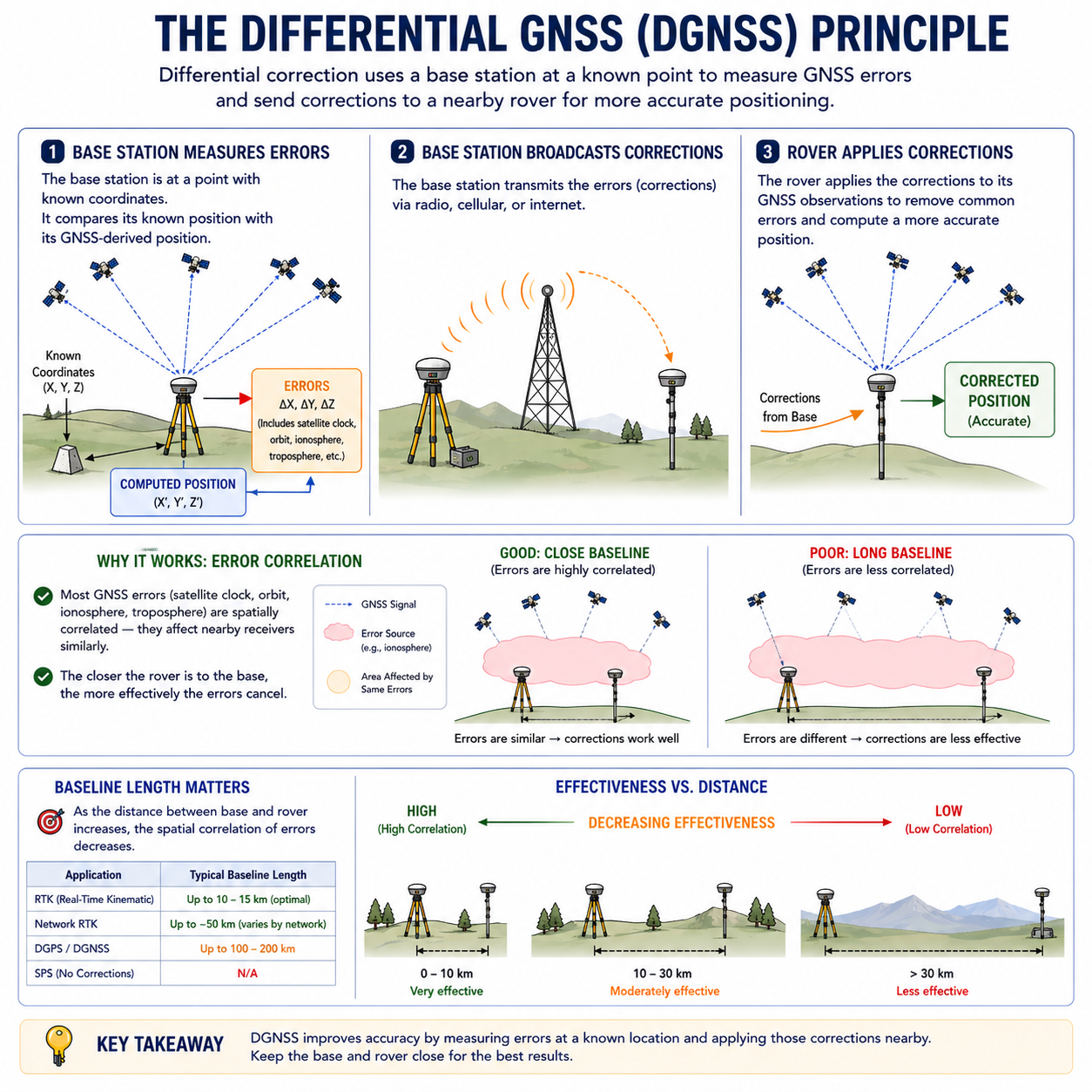
Differential correction relies on a simple concept: place a receiver (base station) on a point with known coordinates. The base station computes the difference between its known position and its GNSS-derived position. This difference represents the combined errors affecting the GNSS signals at that location and time. These corrections are then applied to the rover receiver operating nearby.
Why it works: Most GNSS errors (satellite clock, orbit, ionosphere, troposphere) are spatially correlated -- they affect nearby receivers similarly. The closer the rover is to the base, the more effectively the errors cancel.
Baseline length matters: As the distance between base and rover increases, the spatial correlation of errors decreases. For RTK, baselines are typically limited to 10-15 km for optimal performance.
GNSS Error Sources
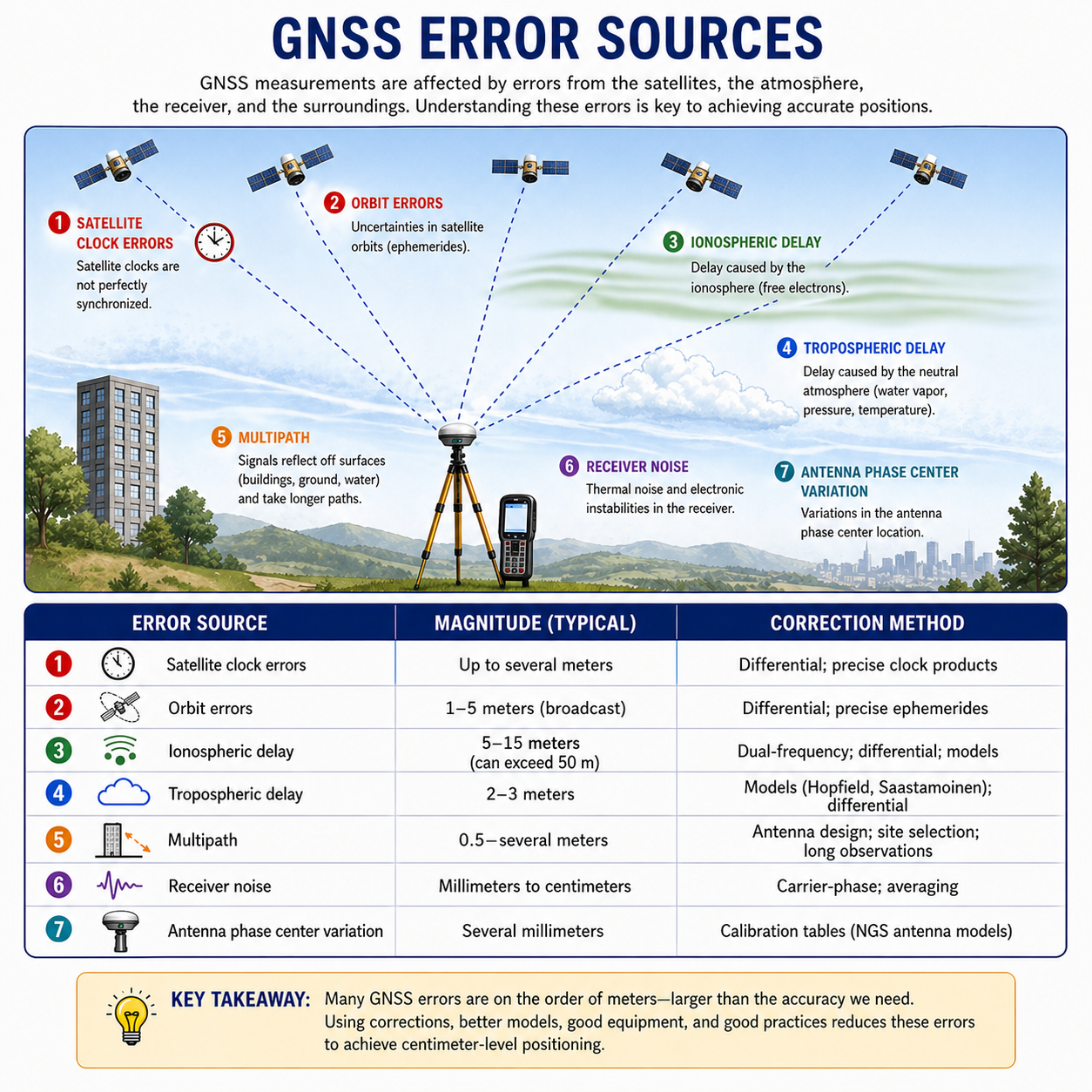
Typical error magnitudes below are drawn from Van Sickle, GPS for Land Surveyors (4th Ed.), Ch. 4, with iono/tropo ranges reflective of NGS operational guidance.
| Error Source | Magnitude | Correction Method |
|---|---|---|
| Satellite clock errors | Up to several meters | Differential; precise clock products |
| Orbit errors | 1-5 meters (broadcast) | Differential; precise ephemerides |
| Ionospheric delay | 5-15 meters (can exceed 50 m) | Dual-frequency; differential; models |
| Tropospheric delay | 2-3 meters | Models (Hopfield, Saastamoinen); differential |
| Multipath | 0.5-several meters | Antenna design; site selection; long observations |
| Receiver noise | Millimeters to centimeters | Carrier-phase; averaging |
| Antenna phase center variation | Several millimeters | Calibration tables (NGS antenna models) |
CORS -- Continuously Operating Reference Stations
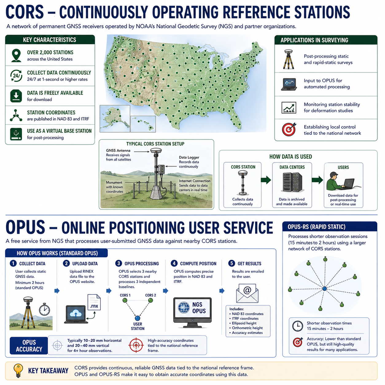
CORS is a network of permanent GNSS receivers operated by NOAA's National Geodetic Survey (NGS) and partner organizations.
Key characteristics:
- Over 2,000 stations across the United States
- Stations collect data continuously (24/7) at 1-second or higher rates
- Data is freely available for download
- Station coordinates are published in NAD 83 and ITRF
- Users can download CORS data to use as a virtual base station for post-processing
Applications in surveying:
- Post-processing static and rapid-static surveys
- Input to OPUS for automated processing
- Monitoring station stability for deformation studies
- Establishing local control tied to the national network
OPUS -- Online Positioning User Service
OPUS is a free service from NGS that processes user-submitted GNSS data against nearby CORS stations.
How it works:
- The user collects static GNSS data (minimum 2 hours for standard OPUS; 15 minutes for OPUS-RS)
- The data file (RINEX format) is uploaded to the OPUS website
- OPUS selects three nearby CORS stations and processes three independent baselines
- The results (NAD 83 and ITRF coordinates, ellipsoid height, orthometric height) are emailed to the user
OPUS accuracy: Typically 10-20 mm horizontal and 20-40 mm vertical for 4+ hour observations (NGS OPUS User Guide; Van Sickle, GPS for Land Surveyors, 4th Ed., Ch. 6).
OPUS-RS (Rapid Static): Processes shorter observation sessions (15 minutes to 2 hours) using a larger network of CORS stations. Accuracy is somewhat lower than standard OPUS.
Real-Time Networks (RTN)
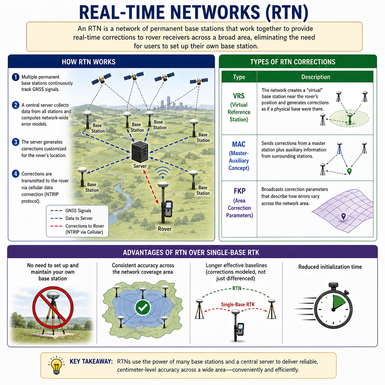
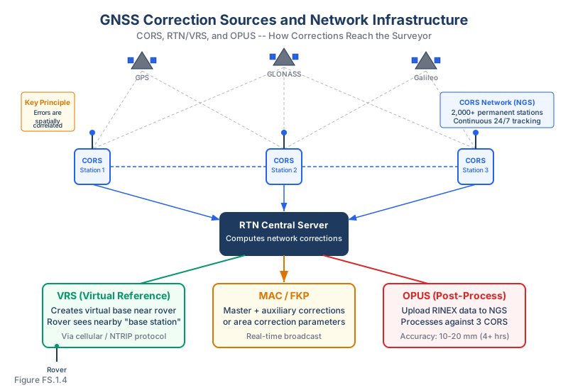
An RTN is a network of permanent base stations that work together to provide real-time corrections to rover receivers across a broad area, eliminating the need for users to set up their own base station.
How RTN works:
- Multiple permanent base stations continuously track GNSS signals
- A central server collects data from all stations and computes network-wide error models
- The server generates corrections customized for the rover's location
- Corrections are transmitted to the rover via cellular data connection (NTRIP protocol)
Types of RTN corrections:
| Type | Description |
|---|---|
| VRS (Virtual Reference Station) | The network creates a "virtual" base station near the rover's position and generates corrections as if a physical base were there |
| MAC (Master-Auxiliary Concept) | Sends corrections from a master station plus auxiliary information from surrounding stations |
| FKP (Area Correction Parameters) | Broadcasts correction parameters that describe how errors vary across the network area |
Advantages of RTN over single-base RTK:
- No need to set up and maintain your own base station
- Consistent accuracy across the network coverage area
- Longer effective baselines (corrections modeled, not just differenced)
- Reduced initialization time
Common wrong path — assuming differential correction fixes everything. Differential correction (including RTK and RTN) cancels errors that are spatially correlated between the base station and the rover — satellite clock errors, orbit errors, ionospheric and tropospheric delays at similar magnitudes. What differential correction does NOT fix: multipath (reflections are site-specific and don't correlate between base and rover), receiver noise, antenna phase-center issues, or mis-identified control points. Students often answer "differential GNSS fixes the error" for any GNSS error source on the exam; that's wrong for multipath specifically. Multipath is reduced by antenna design (choke ring), site selection (away from reflective surfaces), and longer observation times — not by differential correction. Exam questions test this by describing an RTK survey near a metal building with unexpected position scatter; the answer is multipath, and the fix is not "apply more corrections" but "move to a better location."
Quick retrieval check — try before reading on.
▶An RTK survey is being conducted near a large metal warehouse. The rover shows position scatter of 2–5 cm even though the base is only 500 m away, the fix is confirmed, and PDOP is 2.3 (excellent geometry). What is the likely cause, and what should the surveyor do?
Multipath from the metal warehouse walls. The metal surface reflects GNSS signals, creating indirect signal paths that interfere with the direct signals. Even with good geometry and a nearby base, multipath cannot be cancelled by differential correction because the reflection pattern is specific to the rover's location (not the base's). Possible fixes:
- Relocate the rover — move farther from the reflective surface if possible. Even 20–30 m from the wall may significantly reduce multipath.
- Use a choke-ring antenna — specifically designed to reject multipath from low-elevation angles.
- Observe for longer — multipath has a characteristic time signature and partially averages out over longer observations.
- Switch to conventional methods — if RTK reliability near this structure is not sufficient, set up a total station and traverse from reliable control nearby.
Increasing the number of satellites or applying additional differential corrections will not help — the problem is not the base-to-rover correction, it is the signals arriving at the rover. Knowing this distinction saves field time and produces accurate coordinates.
Ephemerides
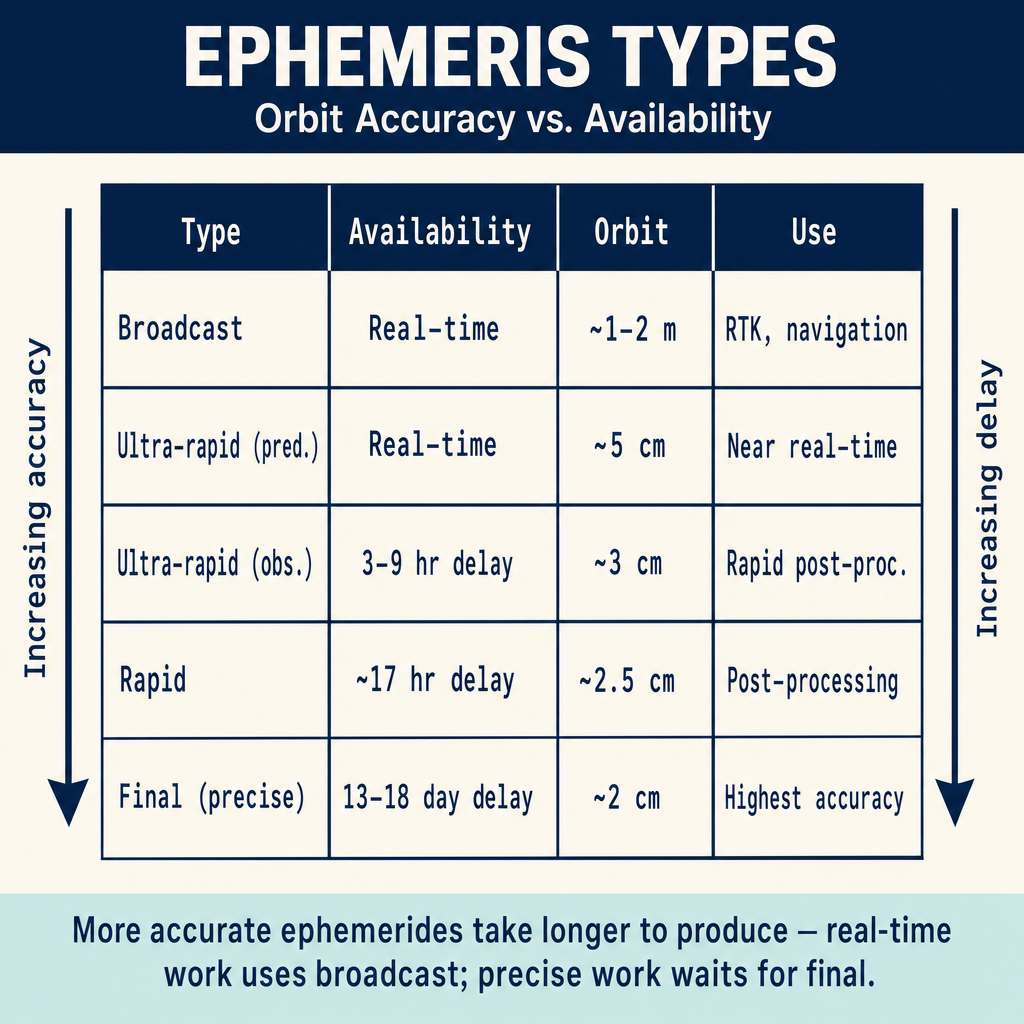
The satellite ephemeris (plural: ephemerides) describes the satellite's position as a function of time. More accurate ephemerides yield more accurate positioning.
| Ephemeris Type | Availability | Orbit Accuracy | Application |
|---|---|---|---|
| Broadcast | Real-time | ~1-2 meters | RTK, navigation |
| Ultra-rapid (predicted) | Real-time | ~5 cm | Near real-time applications |
| Ultra-rapid (observed) | 3-9 hours delay | ~3 cm | Rapid post-processing |
| Rapid | ~17 hours delay | ~2.5 cm | Post-processing |
| Final (precise) | ~13-18 days delay | ~2 cm | Highest-accuracy post-processing |
Orbit-accuracy values reflect the current IGS Products specification (igs.org/products); latencies and accuracies are periodically updated by the IGS Analysis Center Coordinator.
Exam Tips
- Differential correction works because GNSS errors are spatially correlated -- they affect nearby receivers similarly
- Ionospheric delay is the largest error source; dual-frequency receivers can largely eliminate it
- CORS data is free and publicly available from NGS
- OPUS requires a minimum of 2 hours of static data (OPUS-RS: 15 minutes)
- RTN eliminates the need for a user-operated base station; corrections come via cellular data
- VRS creates a virtual base station near the rover -- the rover "thinks" it has a nearby base
- Multipath cannot be corrected by differential methods -- it is site-specific
- Precise ephemerides are more accurate but available only after a delay; broadcast ephemerides are used for real-time work
- The FS exam may ask about which error sources are eliminated by differential correction and which are not
Related Test Topics
- GNSS/GPS Methods (Topic 1.3)
- Control Surveys and Standards (Topic 1.5)
- Datums and Conversions (Module 4, Topic 4.5)
- State Plane Coordinates (Module 4, Topic 4.6)
Further Reading
Authoritative sources for deeper study
Van Sickle, GPS for Land Surveyors (4th Ed.), Ch. 6 — CORS, OPUS, and reference networks.
Penn State GEOG 862 — GPS and GNSS for Geospatial Professionals — Free open courseware covering GNSS fundamentals, observables, RTK, and network solutions.
Leica GPS Basics (1999) — Plain-language introduction to GPS principles and field methods.
NGS Geodetic Glossary (1986, NOAA repository) — Authoritative definitions for geodetic, GNSS, and surveying terms.
Last updated: 2026-04-17