FS Exam Preparation
Comprehensive preparation for the Fundamentals of Surveying (FS) exam. 7 modules covering all 7 exam domains with 60 in-depth topics.
Module 1: Surveying Processes & Methods
Module 2: Mapping Processes & Methods
Module 3: Boundary Law & Real Property
Module 4: Surveying Principles & Geodesy
Module 5: Survey Computations
Module 6: Business Concepts
Vertical Curves
Learning Objectives
After completing this topic, you should be able to:
- Compute elevations at any point on a vertical curve
- Determine the location and elevation of the high or low point
- Distinguish between crest and sag curves
- Calculate the rate of grade change
- Solve for minimum curve length given design criteria
Overview
Vertical curves provide a smooth transition between two different grades (slopes) along a route. They are modeled as parabolic curves, which produce a constant rate of change of grade. The FS exam tests your ability to compute elevations at specific stations on a vertical curve, find the high or low point, and understand design criteria. Vertical curve problems are highly formulaic and predictable.
Key Concepts
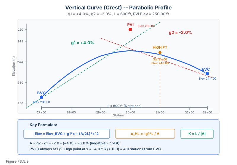
Vertical Curve Terminology
- BVC (Beginning of Vertical Curve): Also called PVC (Point of Vertical Curvature)
- EVC (End of Vertical Curve): Also called PVT (Point of Vertical Tangency)
- PVI (Point of Vertical Intersection): Where the two grade lines meet (at the midpoint of the curve)
- g1: Grade of the incoming tangent (in percent, e.g., +3.5%)
- g2: Grade of the outgoing tangent (in percent)
- L: Length of the vertical curve (in stations or feet/meters)
- A: Algebraic difference of grades: A = g2 - g1
Types of Vertical Curves
| Type | Condition | Shape |
|---|---|---|
| Crest curve | g1 > g2 (grade decreases) | Convex (hill) |
| Sag curve | g1 < g2 (grade increases) | Concave (valley) |
Note: A = g2 - g1 is negative for crest curves and positive for sag curves.
The Parabolic Equation
The elevation at any point on the vertical curve at distance x from the BVC (Ghilani & Wolf, Elementary Surveying, 13th Ed., §25.3, Eq. 25.3; high/low point at §25.6):
Elevation = Elevation_BVC + g1 * x + ((g2 - g1) / (2 * L)) * x^2
Or equivalently:
Elevation = Elevation_BVC + g1 * x + (A / (2 * L)) * x^2
Where:
- x = horizontal distance from BVC (in same units as L)
- g1 and g2 are in decimal form if x and L are in the same units, OR in percent if x and L are in stations
Important: Keep units consistent. If grades are in percent (e.g., +3%), then x and L should be in stations (hundreds of feet). If grades are decimal (e.g., 0.03), then x and L should be in feet.
Elevation of the PVI
Elevation_PVI = Elevation_BVC + g1 * (L/2)
Elevation of the EVC
Elevation_EVC = Elevation_BVC + g1 * L + (A / (2*L)) * L^2
Or: Elevation_EVC = Elevation_PVI + g2 * (L/2)
The Tangent Offset Method
An alternative approach uses the tangent line as a reference:
- Compute the elevation on the tangent at distance x from BVC: Tangent_elev = Elev_BVC + g1 * x
- Compute the offset from the tangent to the curve: Offset = (A / (2*L)) * x^2
- Curve elevation = Tangent elevation + Offset
High or Low Point Location
The high point (on crest curves) or low point (on sag curves) occurs where the slope of the curve is zero:
Distance from BVC to high/low point:
x_HL = -(g1 * L) / A = -(g1 * L) / (g2 - g1)
Or equivalently:
x_HL = (g1 / (g1 - g2)) * L
This point exists on the curve only if 0 < x_HL < L. If x_HL is outside this range, the high or low point is at one of the endpoints (BVC or EVC).
Rate of Grade Change
r = A / L = (g2 - g1) / L
This is the rate at which the grade changes per unit of horizontal distance. For a parabolic curve, this rate is constant.
K-Value
The K-value is the horizontal distance required to produce a 1% change in grade:
K = L / |A|
K-values are used in design standards to determine minimum curve lengths for stopping sight distance, passing sight distance, and headlight illumination.
Vertical Curve Workflow
Use this order on the FS exam:
- Convert grades and distance units consistently. Percent with stations, or decimal with feet/meters.
- Compute A = g2 - g1. The sign tells you crest or sag.
- Locate BVC and EVC. For an equal-tangent curve, BVC = PVI - L/2 and EVC = PVI + L/2.
- Compute BVC elevation. Work backward from the PVI using g1.
- Use x from the BVC. Do not use station distance from the PVI in the parabolic equation unless you transform it.
- Check high/low point. Compute x = -g1L/A and confirm it lies between 0 and L.
Most wrong answers come from using the right formula with x measured from the wrong point.
Quick Unit Check
If g1 = +2.5% and x = 300 ft, the tangent rise is:
- percent/stations: 2.5 x 3 = 7.5 ft
- decimal/feet: 0.025 x 300 = 7.5 ft
Both are valid. But 2.5 x 300 = 750 ft is invalid because it mixes percent with feet.
Worked Example
Given: g1 = +4.0%, g2 = -2.0%, L = 600 ft (6 stations), Elevation of PVI = 250.00 ft, Station of PVI = 30+00
Step 1: A = g2 - g1 = -2.0 - (+4.0) = -6.0% (crest curve)
Step 2: Station of BVC = 30+00 - 3+00 = 27+00
Step 3: Elevation of BVC = 250.00 - 4.0% * 300 = 250.00 - 12.00 = 238.00 ft
Step 4: Elevation at station 29+00 (x = 200 ft = 2 stations from BVC):
Elev = 238.00 + 4.0(2) + (-6.0 / (2 * 6)) * 2^2
Elev = 238.00 + 8.00 + (-0.5) * 4 = 238.00 + 8.00 - 2.00 = 244.00 ft
Step 5: High point location: x = -(4.0 * 6) / (-6.0) = 4.0 stations = 400 ft from BVC
Station of high point = 27+00 + 4+00 = 31+00
Step 6: Elevation at high point:
Elev = 238.00 + 4.0(4) + (-6.0 / 12) * 16 = 238.00 + 16.00 - 8.00 = 246.00 ft
Common wrong path — mixing percent and decimal in one equation. The parabolic equation only works if the units of , , and are consistent. Two valid conventions:
- Percent + stations: grades in % (e.g., +4.0), x and L in stations (e.g., 2 stations, 6 stations)
- Decimal + feet: grades in decimal (e.g., +0.040), x and L in feet (e.g., 200 ft, 600 ft)
Mixing them (grade in percent while x is in feet) produces answers off by factors of 100. A fast sanity check: should give you the elevation change along the tangent line in the same elevation units as the BVC. If ft of rise, you've used percent with feet — the answer is 100× too large. Use 4.0 × 2 stations = 8 ft rise (percent + stations) or 0.04 × 200 ft = 8 ft rise (decimal + feet) instead.
Quick retrieval check — try before reading on.
▶A crest vertical curve has g₁ = +3.0%, g₂ = −1.0%, L = 400 ft. Where is the high point, measured from the BVC?
stations = 300 ft from the BVC. This falls within 0 < 300 < 400, so the high point is on the curve (not at an endpoint). The denominator A = g₂ − g₁ is negative for a crest — the negative sign outside the equation flips it positive to keep the station positive. If A came out positive (sag curve with g₁ negative and g₂ positive), the same formula still locates the low point.
Exam Tips
- Always determine whether grades are in percent or decimal and match them to the distance units
- The PVI is always at the midpoint of the curve (L/2 from both BVC and EVC)
- A crest curve has a high point; a sag curve has a low point
- The high/low point is NOT at the PVI unless g1 = -g2 (symmetric about zero)
- When the problem gives the PVI elevation and station, compute the BVC values first before using the parabolic equation
- Check that the high/low point x value falls between 0 and L -- otherwise it is at BVC or EVC
- Vertical curve problems on the FS exam almost always follow the same steps: find BVC, apply the equation, find the answer
- K-value = L / |A| is used for design; know what it means but computation is straightforward
Related Test Topics
- Horizontal Curves (Topic 5.7)
- Slopes, Grades, and Interpolation (Topic 5.10)
- Volume Calculations and Earthwork (Topic 5.9)
Further Reading
Authoritative sources for deeper study
Wolf & Ghilani, Elementary Surveying — Chapters on horizontal and vertical curve computations.
Kavanagh, Surveying with Construction Applications (7th Ed.) — Combined surveying and construction-layout reference.
Last updated: 2026-04-17