FS Exam Preparation
Comprehensive preparation for the Fundamentals of Surveying (FS) exam. 7 modules covering all 7 exam domains with 60 in-depth topics.
Module 1: Surveying Processes & Methods
Module 2: Mapping Processes & Methods
Module 3: Boundary Law & Real Property
Module 4: Surveying Principles & Geodesy
Module 5: Survey Computations
Module 6: Business Concepts
Land Development & Subdivisions
Learning Objectives
After completing this topic, you should be able to:
- Describe the subdivision process from planning through recording
- Explain the surveyor's role in land development projects
- Identify the components of a subdivision plat
- Understand right-of-way and easement considerations in subdivisions
- Describe utility and grading considerations for lot layout
- Explain the relationship between preliminary and final plats
Overview
Land development encompasses the process of converting undeveloped or agricultural land into buildable lots, streets, and public spaces. The surveyor plays a central role throughout this process -- from the initial boundary and topographic surveys through final plat preparation and construction staking.
Subdivision is the legal process of dividing a larger parcel of land into smaller lots, typically for sale and development. The subdivision plat is a recorded document that defines the lots, streets, easements, and other elements of the development. Understanding the subdivision process is essential for the FS exam, as it integrates nearly every aspect of surveying practice.
Key Concepts
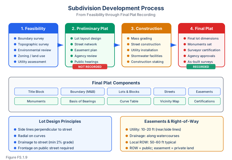
The Subdivision Process
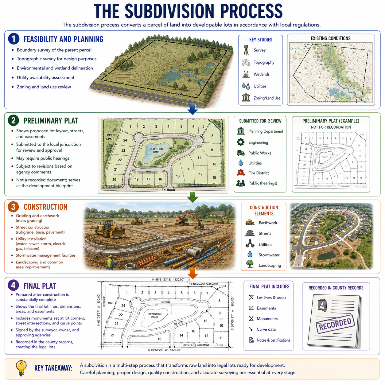
The typical subdivision process follows these stages:
1. Feasibility and Planning:
- Boundary survey of the parent parcel
- Topographic survey for design purposes
- Environmental and wetland delineation
- Utility availability assessment
- Zoning and land use review
2. Preliminary Plat:
- Shows proposed lot layout, streets, and easements
- Submitted to the local jurisdiction for review and approval
- May require public hearings
- Subject to revisions based on agency comments
- Not a recorded document; serves as the development blueprint
3. Construction:
- Grading and earthwork (mass grading)
- Street construction (subgrade, base, pavement)
- Utility installation (water, sewer, storm, electric, gas, telecom)
- Stormwater management facilities
- Landscaping and common area improvements
4. Final Plat:
- Prepared after construction is substantially complete
- Shows the final lot lines, dimensions, areas, and easements
- Includes monuments set at lot corners, street intersections, and curve points
- Signed by the surveyor, owner, and approving agencies
- Recorded in the county records, creating the legal lots
Components of a Subdivision Plat
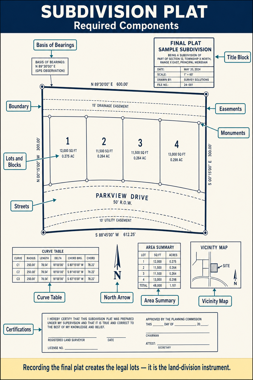
A typical subdivision plat includes:
| Component | Description |
|---|---|
| Title block | Subdivision name, location (section, township, range or other reference), county, state |
| Boundary | Metes and bounds description of the subdivision perimeter with bearings, distances, and curve data |
| Lots and blocks | Numbered lots organized in blocks; dimensions, areas, and bearings for each lot line |
| Streets | Right-of-way widths, centerline data, curve data (radius, arc length, chord, delta angle) |
| Easements | Utility easements, drainage easements, access easements with dimensions |
| Monuments | Types and locations of monuments set (and found) |
| Basis of bearings | The reference for all bearings shown on the plat |
| Notes and certifications | Surveyor's certificate, owner's dedication, agency approvals |
| Vicinity map | Shows the subdivision location relative to surrounding streets and features |
| Curve table | Tabulates all curve data: radius, delta, arc length, chord bearing, chord distance |
| Area summary | Total area, lot areas, street areas, open space areas |
Lot Design Considerations
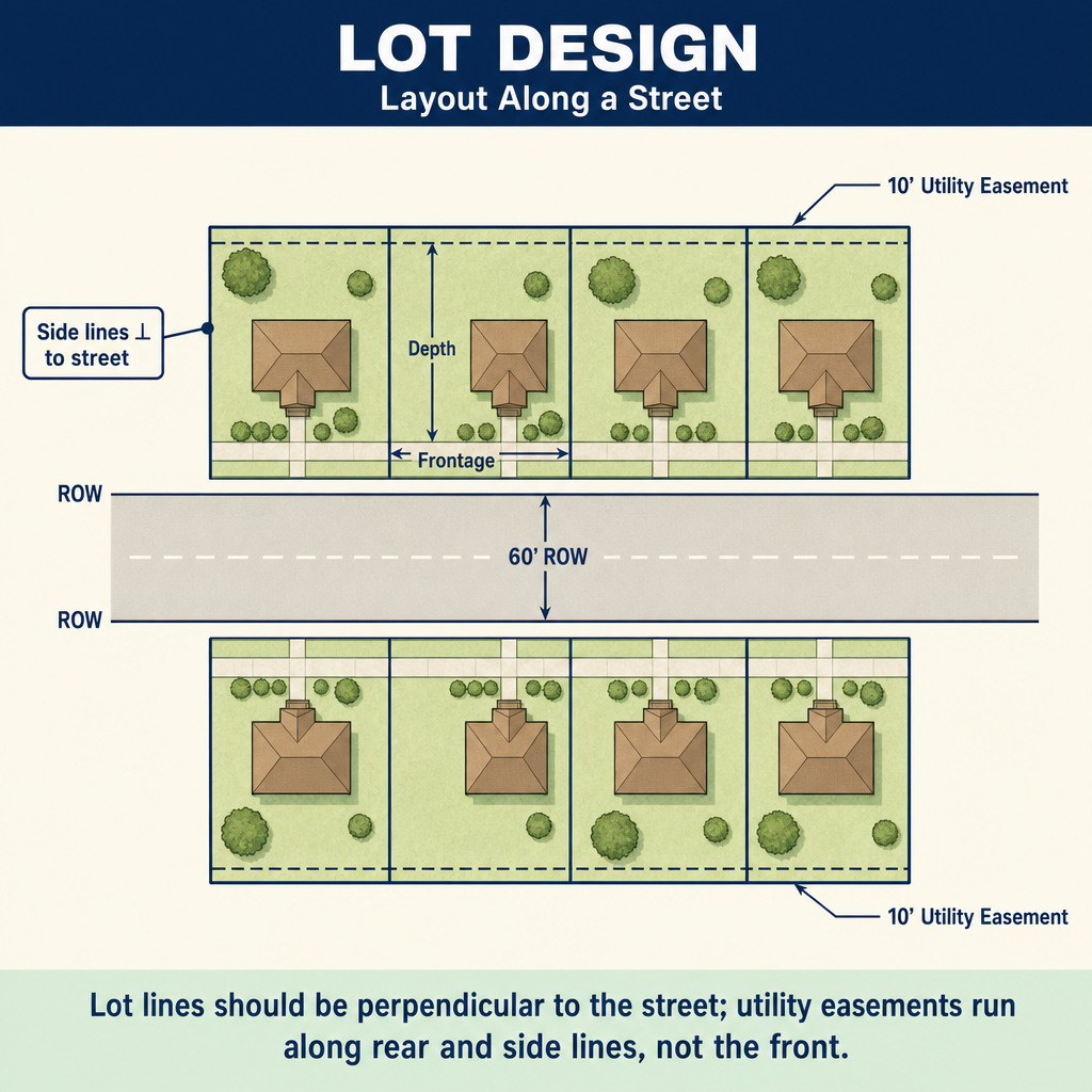
Minimum lot dimensions:
- Most jurisdictions specify minimum lot width (at the building setback line), minimum lot depth, and minimum lot area
- Corner lots typically require additional width to accommodate side setbacks along the street
Lot orientation:
- Lots should have frontage on a public street
- Side lot lines should be approximately perpendicular to the street (or radial to curves)
- Avoid "flag lots" (lots with narrow access strips) unless necessary
- Consider solar orientation and view corridors
Grading and drainage:
- Each lot must drain to the street or a designated drainage facility
- Minimum lot grades: typically 2% away from buildings
- Maximum lot slopes: typically 3:1 (33%) for usable areas
- Retaining walls may be needed for steep lots
Streets and Right-of-Way
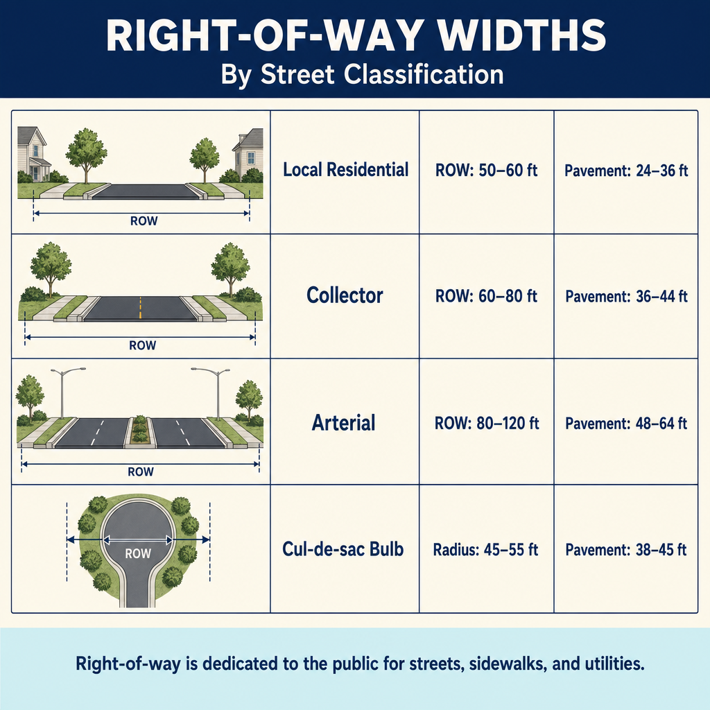
Right-of-way (ROW): The public land dedicated for street, sidewalk, and utility purposes.
| Street Type | Typical ROW Width | Pavement Width |
|---|---|---|
| Local residential | 50-60 ft (15-18 m) | 24-36 ft (7-11 m) |
| Collector | 60-80 ft (18-24 m) | 36-44 ft (11-13 m) |
| Arterial | 80-120 ft (24-37 m) | 48-64 ft (15-20 m) |
| Cul-de-sac bulb | 45-55 ft radius | 38-45 ft radius |
Typical widths consistent with AASHTO, A Policy on Geometric Design of Highways and Streets ("Green Book"), and ITE Recommended Practice for Subdivision Streets; locally adopted standards vary by municipality.
Curve design for subdivision streets:
- Minimum centerline radius depends on design speed and street classification
- Curve data on the plat includes: radius (R), delta angle, arc length (L), chord bearing, chord distance
- Reverse curves (S-curves) should have tangent sections between them
Easements
Easements in subdivisions typically include:
- Utility easements: Usually 10-20 ft (3-6 m) wide along rear and/or side lot lines for water, sewer, electric, gas, and telecom
- Drainage easements: Along watercourses, storm drains, and detention facilities
- Access easements: For lots without direct street frontage (avoid when possible)
- Sight distance easements: At intersections to maintain clear sight triangles
Common wrong path — easements along the front of residential lots. On a typical residential subdivision plat, utility easements run along the rear and side lot lines, not along the front. The front of the lot is already within the public right-of-way (the dedicated street area), where utilities are installed in the ROW itself — no separate easement is needed at the front because the entire ROW is public. Students sometimes answer "front lot line" when asked where utility easements are typically placed, which produces a plat with a redundant easement inside the ROW and no coverage at the rear where the utility actually needs to access the lot. The correct answer: easements usually line the rear (for mains) and side (for service laterals) lot lines, 10–20 ft wide, with the front being within the dedicated ROW.
Quick retrieval check — try before reading on.
▶A subdivision plat shows: a 60-ft-wide public street ROW on the front, a 10-ft-wide utility easement on the rear, and 5-ft-wide utility easements on each side. A new sewer main is to be installed serving the lots. Where is the main most likely located, and why?
The main is most likely in the 10-ft rear easement (or within the street ROW, depending on the subdivision's design). Sewer mains in residential subdivisions typically run along the rear of lots when gravity flow requires a specific alignment, or along the street in the ROW when flow direction permits. Service laterals connect from the main to each lot through the side easements.
The 5-ft side easements are usually for service laterals (shallower, smaller utilities like gas, electric, telecom) rather than for major gravity sewers. The front (inside the 60-ft ROW) is where surface utilities like street lighting, hydrants, and shallow utility laterals are installed — no separate easement needed because the entire ROW is already dedicated public area. The question tests whether the student understands the standard arrangement: front = ROW (no separate easement), sides = laterals, rear = primary utility corridor.
The Surveyor's Role
The surveyor is involved throughout the land development process:
- Boundary survey of the parent parcel
- Topographic survey for engineering design
- ALTA/NSPS survey if required for financing
- Preliminary plat preparation (or support to the engineer/planner)
- Construction staking for streets, utilities, grading
- Final monumentation of lot corners and control points
- Final plat preparation, signing, and recording
- As-built surveys documenting constructed improvements
Exam Tips
- A preliminary plat is not recorded; the final plat is recorded and creates the legal lots
- The subdivision plat must include a metes and bounds description of the entire subdivision perimeter
- Lot lines should be approximately perpendicular to the street centerline (or radial on curves)
- Utility easements are typically along rear and side lot lines, not the front (which is within the ROW)
- The basis of bearings must be clearly stated on the plat
- Curve data required on plats: radius, delta angle, arc length, chord bearing, chord distance
- Each lot must have adequate drainage -- typically graded to drain toward the street
- The FS exam may test your understanding of plat components or lot design principles
- Right-of-way is dedicated to the public; easements grant specific use rights while the underlying ownership remains with the lot owner
Related Test Topics
- Construction Surveys and Staking (Topic 1.8)
- Plats, ROS, and ALTA (Module 2, Topic 2.3)
- Route Surveying and Alignments (Module 4, Topic 4.3)
- Metes and Bounds Descriptions (Module 3, Topic 3.6)
Further Reading
Authoritative sources for deeper study
Kavanagh, Surveying with Construction Applications (7th Ed.) — Combined surveying and construction-layout reference.
2026 ALTA/NSPS Land Title Survey Standards — Current minimum standard detail requirements for ALTA/NSPS land title surveys (effective February 23, 2026).
Wolf & Ghilani, Elementary Surveying — An Introduction to Geomatics (13th Ed., 2012) — Comprehensive surveying text covering instruments, field procedures, and computations.
MUTCD 2023 Part 6 — Temporary Traffic Control — Federal standard for work-zone traffic control devices and surveyor safety.
Last updated: 2026-05-30