FS Exam Preparation
Comprehensive preparation for the Fundamentals of Surveying (FS) exam. 7 modules covering all 7 exam domains with 60 in-depth topics.
Module 1: Surveying Processes & Methods
Module 2: Mapping Processes & Methods
Module 3: Boundary Law & Real Property
Module 4: Surveying Principles & Geodesy
Module 5: Survey Computations
Module 6: Business Concepts
Vertical Surveys & Leveling
Learning Objectives
After completing this topic, you should be able to:
- Perform level circuit computations (HI, BS, FS, elevations)
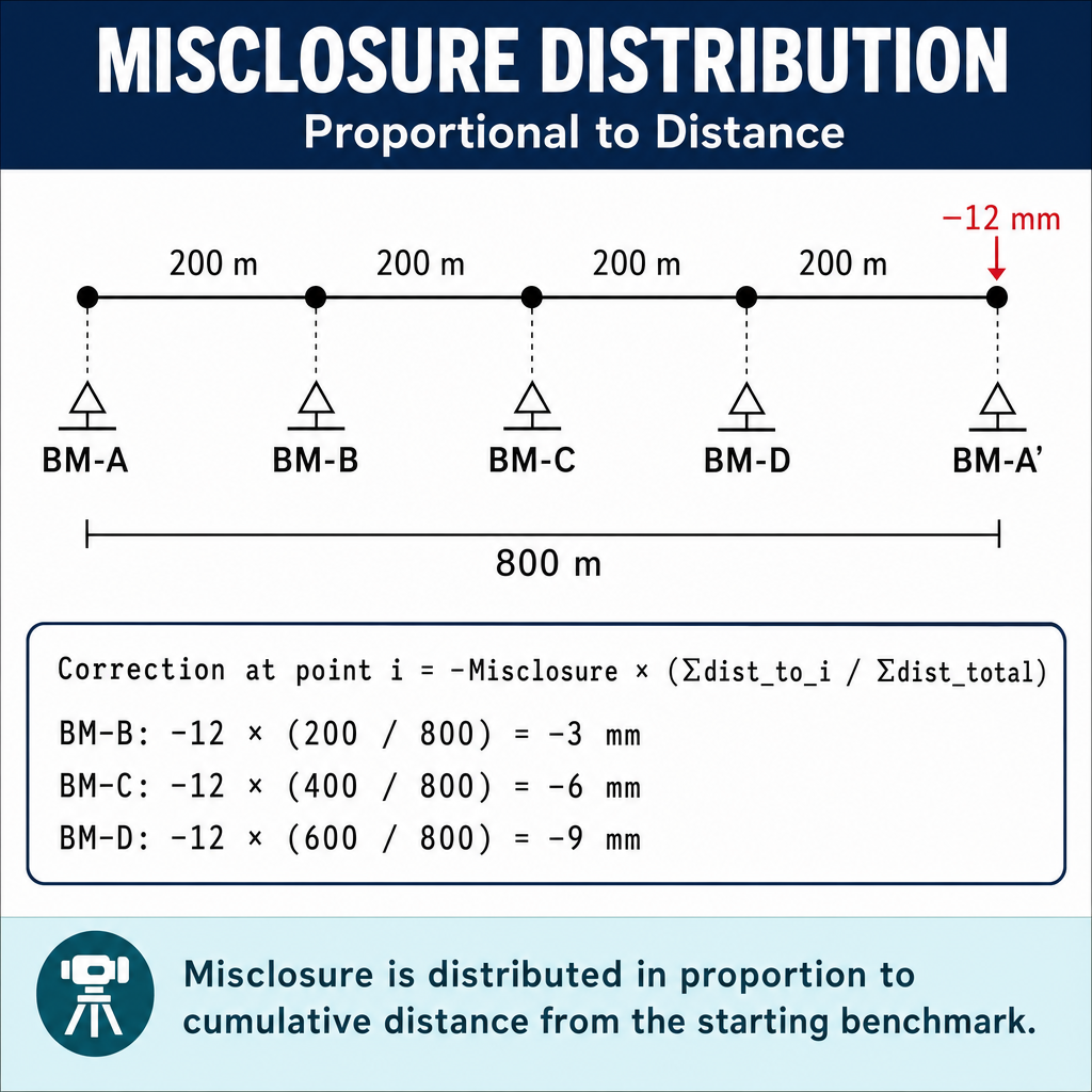
- Calculate and distribute leveling misclosure
- Compute curvature and refraction corrections
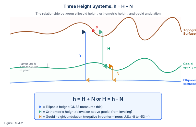
- Distinguish between orthometric and ellipsoid heights
- Apply geoid height (undulation) to convert between height systems
- Calculate trigonometric elevations from total station data
Overview
Vertical surveying determines the elevations of points relative to a datum (typically mean sea level, approximated by the geoid). This topic focuses on the computational aspects of leveling -- the mathematics behind the field procedures described in Module 1, Topic 1.2.
The FS exam frequently tests leveling computations, misclosure distribution, and the relationship between orthometric height, ellipsoid height, and geoid height.
Key Concepts
Level Circuit Computations
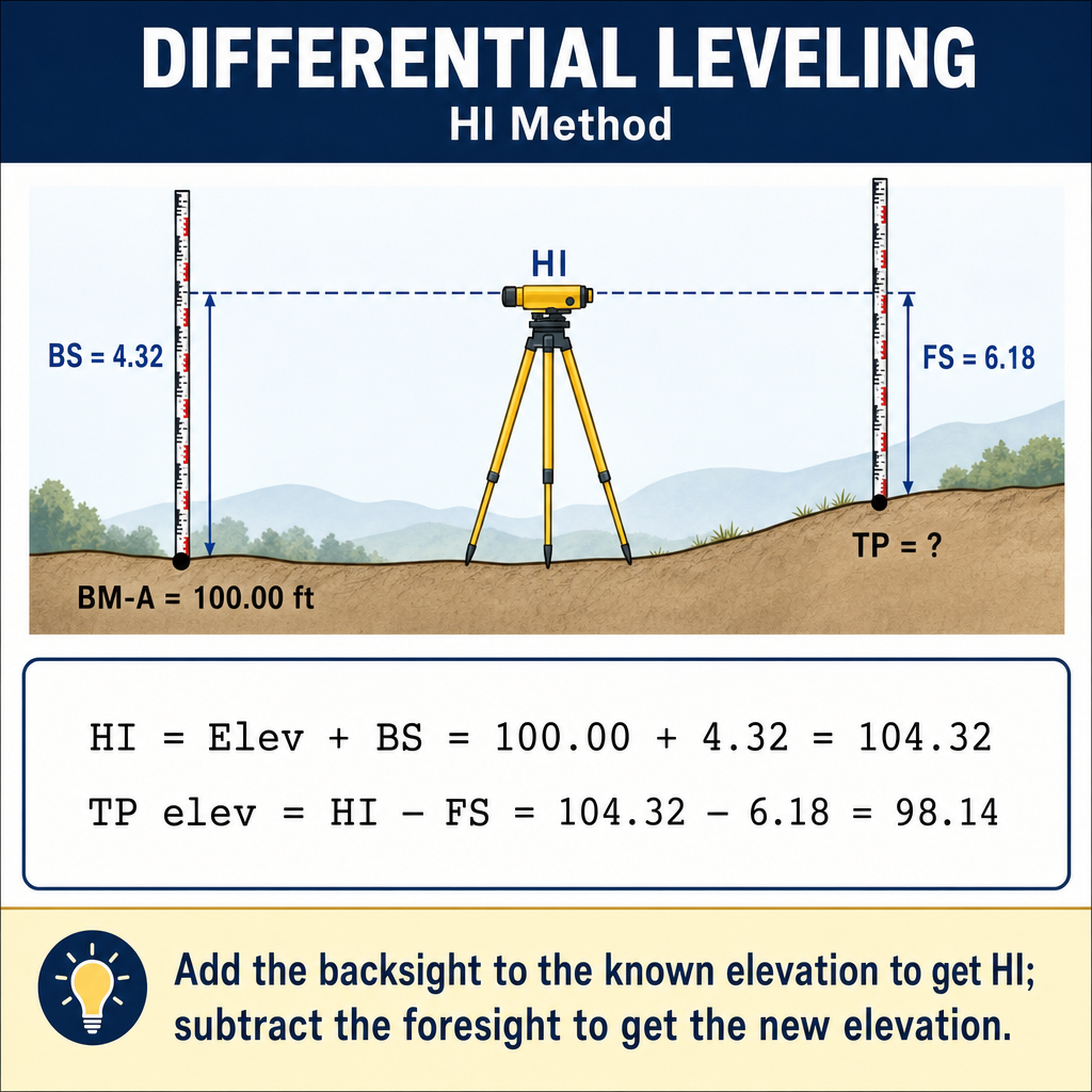
The fundamental leveling equations:
Where HI is the Height of Instrument (elevation of the line of sight), BS is the backsight rod reading, and FS is the foresight rod reading.
Example level circuit:
| Station | BS | HI | FS | Elevation |
|---|---|---|---|---|
| BM A | 6.32 | 106.32 | -- | 100.00 (known) |
| TP 1 | 5.18 | 103.47 | 8.03 | 98.29 |
| TP 2 | 7.44 | 105.16 | 5.75 | 97.72 |
| BM B | -- | -- | 4.89 | 100.27 |
Check: Sum of BS - Sum of FS = Last Elev - First Elev (6.32 + 5.18 + 7.44) - (8.03 + 5.75 + 4.89) = 18.94 - 18.67 = 0.27 100.27 - 100.00 = 0.27 (checks)
Misclosure and Adjustment
If the level circuit closes on a known benchmark, the difference between the computed and known elevation is the misclosure.
Misclosure = Computed Elevation - Known Elevation
Allowable misclosure (Third Order) — Federal Geodetic Control Subcommittee, Standards and Specifications for Geodetic Control Networks (1984); see also NGS NOS NGS 5:
Where K is the distance in km and M is the distance in miles.
Example: A level circuit covers 4 km. Third Order allowable misclosure = 12 x sqrt(4) = 12 x 2 = 24 mm.
Distributing misclosure:
The misclosure is distributed proportionally to the distance (or number of setups) between turning points:
Where di is the cumulative distance to turning point i and D_total is the total circuit distance.
Curvature and Refraction
The combined effect of earth curvature and atmospheric refraction (Ghilani & Wolf, Elementary Surveying, 13th Ed., Ch. 4):
The combined effect makes distant rod readings too high (the earth curves away and refraction bends the line of sight downward, but curvature dominates).
Example: Sight distance = 200 m = 0.2 km C&R = 0.0675 x (0.2)^2 = 0.0675 x 0.04 = 0.003 m = 3 mm (negligible for most work)
Example: Sight distance = 1 km C&R = 0.0675 x 1^2 = 0.068 m = 68 mm (significant)
Balanced sights (equal BS and FS distances) cancel curvature and refraction effects.
Common wrong path — forgetting that balanced sights also cancel collimation error. Balancing backsight and foresight distances at each setup is often taught as "the way to eliminate curvature and refraction." That's true — but balanced sights also cancel collimation error (the systematic error from a level's line of sight not being exactly horizontal when the bubble is centered). Collimation error produces a constant slope in the line of sight; when BS and FS distances are equal, the collimation effect adds the same amount to both readings and exactly cancels in BS − FS. Unbalanced sights, by contrast, let collimation error accumulate into the elevation difference — often more seriously than curvature and refraction for ordinary level instruments. The lesson: balance your sights not only for long shots (where C&R dominates) but at every setup (where collimation dominates for shorter shots). A peg test quantifies collimation; balanced sights neutralize it.
Quick retrieval check — try before reading on.
▶A level has a collimation error of +2 mm per 30 m (line of sight tilts slightly upward). You are running levels with BS distance 30 m and FS distance 60 m at each setup. Over 10 setups, how large is the accumulated collimation error in the elevation of the last turning point?
At each setup: BS reading picks up an effective error of +2 mm (30 m × 2/30) and FS reading picks up +4 mm (60 m × 2/30). The collimation contribution to the elevation difference is BS_err − FS_err = +2 − (+4) = −2 mm per setup (elevation will be biased 2 mm low at each setup because FS is more affected than BS).
Over 10 setups, the accumulated error is 10 × (−2 mm) = −20 mm, or about 2 cm low. This is a systematic error that does not show up in loop closure (if you return to the starting BM, the error cancels in reverse direction), but it will show up in point-to-point elevation differences and in comparisons with independent control. Balanced sights (30 m BS, 30 m FS) would have made the collimation contribution 0 at each setup — a full 20 mm improvement with no additional field effort.
Three Height Systems
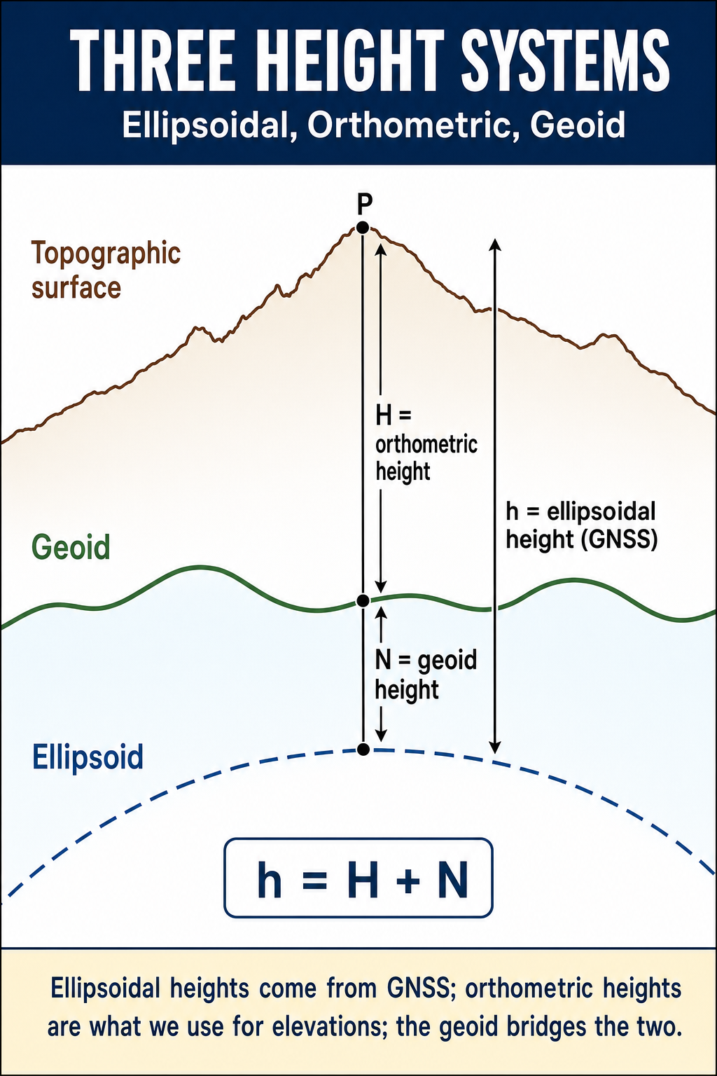
Orthometric height (H):
- Height above the geoid (approximately mean sea level)
- What surveyors and engineers traditionally call "elevation"
- Determined by differential leveling
- Referenced to a vertical datum (NAVD 88 in the U.S.)
Ellipsoid height (h):
- Height above the reference ellipsoid (a mathematical surface)
- What GNSS measures directly
- Not physically meaningful (the ellipsoid does not correspond to a physical surface)
Geoid height (N):
- The separation between the geoid and the ellipsoid at a given location
- Varies across the earth's surface (in the conterminous U.S., N ranges from about -8 m to -53 m using NAD 83/GRS 80 ellipsoid)
The fundamental relationship:
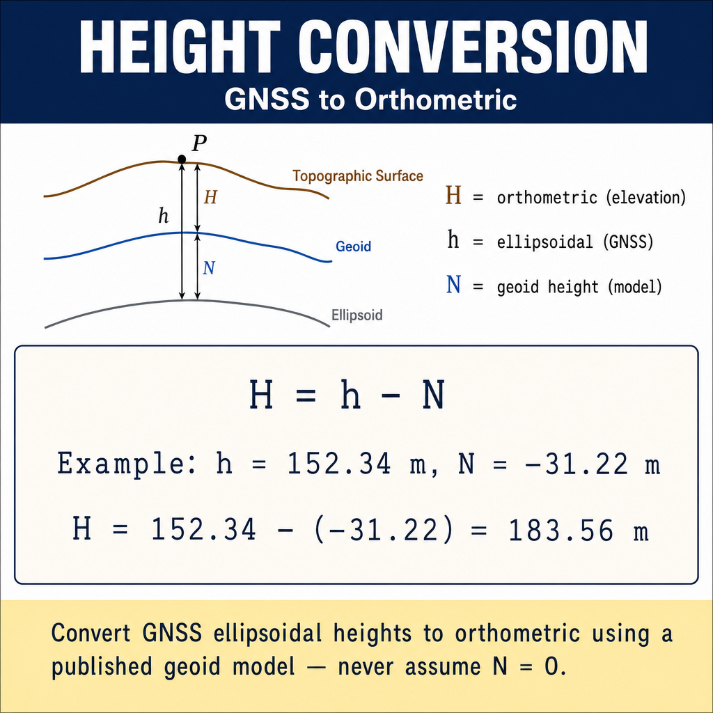
Or equivalently:
Orthometric height = Ellipsoid height - Geoid height
Example: A GNSS survey measures an ellipsoid height of h = 245.320 m. The geoid model gives N = −28.450 m at that location (negative because the geoid is below the ellipsoid in the conterminous U.S.).
The orthometric height is 273.770 m. Because the geoid surface is 28.45 m below the ellipsoid at this location, a point 245.32 m above the ellipsoid is 273.77 m above the geoid (mean sea level).
Trigonometric Leveling Computations
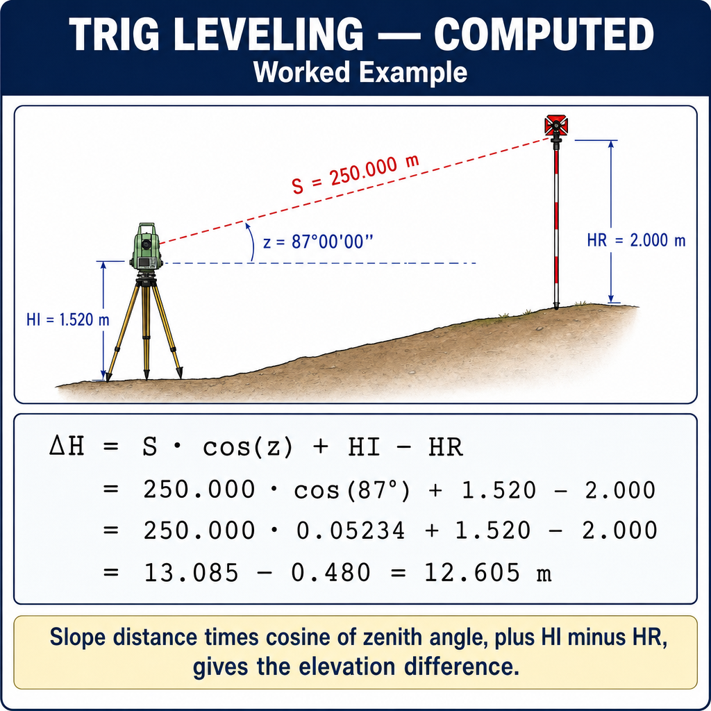
When using a total station:
Where:
- S = slope distance
- alpha = vertical angle from horizontal (positive = upward)
- hi = height of instrument above the occupied point
- ht = height of target/prism above the target point
Alternative using zenith angle (z):
Where z is the zenith angle (90 degrees = horizontal, 0 degrees = straight up).
For reciprocal trigonometric leveling (observations from both ends), average the two elevation differences to reduce refraction effects.
Exam Tips
- HI = Elevation + BS; Elevation = HI - FS -- the fundamental leveling equations
- Sum of BS - Sum of FS = difference in elevation between first and last points (arithmetic check)
- Misclosure is distributed proportionally to cumulative distance through the level circuit
- Allowable misclosure uses sqrt(distance) -- not distance squared
- Balanced sights cancel curvature and refraction -- this is the most important leveling procedure
- H = h - N (Orthometric height = Ellipsoid height - Geoid height) -- know this relationship
- In the conterminous U.S., geoid height N is negative (geoid is below the ellipsoid)
- GNSS measures ellipsoid height; leveling measures orthometric height; you need a geoid model to convert
- Trigonometric leveling uses slope distance and vertical angle to compute elevation difference
- The FS exam will likely have problems requiring level circuit computations and the h/H/N relationship
Related Test Topics
- Levels and Instruments (Module 1, Topic 1.2)
- GNSS/GPS Methods (Module 1, Topic 1.3)
- Geodetic Coordinates and Surfaces (Topic 4.4)
- Datums and Conversions (Topic 4.5)
Further Reading
Authoritative sources for deeper study
Wolf & Ghilani, Elementary Surveying — An Introduction to Geomatics (13th Ed., 2012) — Comprehensive surveying text covering instruments, field procedures, and computations.
Allan, Principles of Geospatial Surveying (Ethernet Edu mirror) — Survey of geospatial principles, instruments, and adjustment.
NGS Geodetic Glossary (1986, NOAA repository) — Authoritative definitions for geodetic, GNSS, and surveying terms.
Last updated: 2026-04-17