FS Exam Preparation
Comprehensive preparation for the Fundamentals of Surveying (FS) exam. 7 modules covering all 7 exam domains with 60 in-depth topics.
Module 1: Surveying Processes & Methods
Module 2: Mapping Processes & Methods
Module 3: Boundary Law & Real Property
Module 4: Surveying Principles & Geodesy
Module 5: Survey Computations
Module 6: Business Concepts
Map Concepts & Cartography
Learning Objectives
After completing this topic, you should be able to:
- Define map scale and convert between scale representations
- Explain the relationship between map scale and map accuracy
- Describe standard map symbology conventions
- Understand the National Map Accuracy Standards (NMAS)
- Calculate ground distances and areas from map measurements
- Identify the components of a well-designed map
Overview
Cartography is the science and art of mapmaking. While surveyors are not typically cartographers, they must understand fundamental map concepts to create accurate, clear, and standards-compliant deliverables. The FS exam tests basic cartographic principles including scale, accuracy standards, symbology, and map design.
Key Concepts
Map Scale
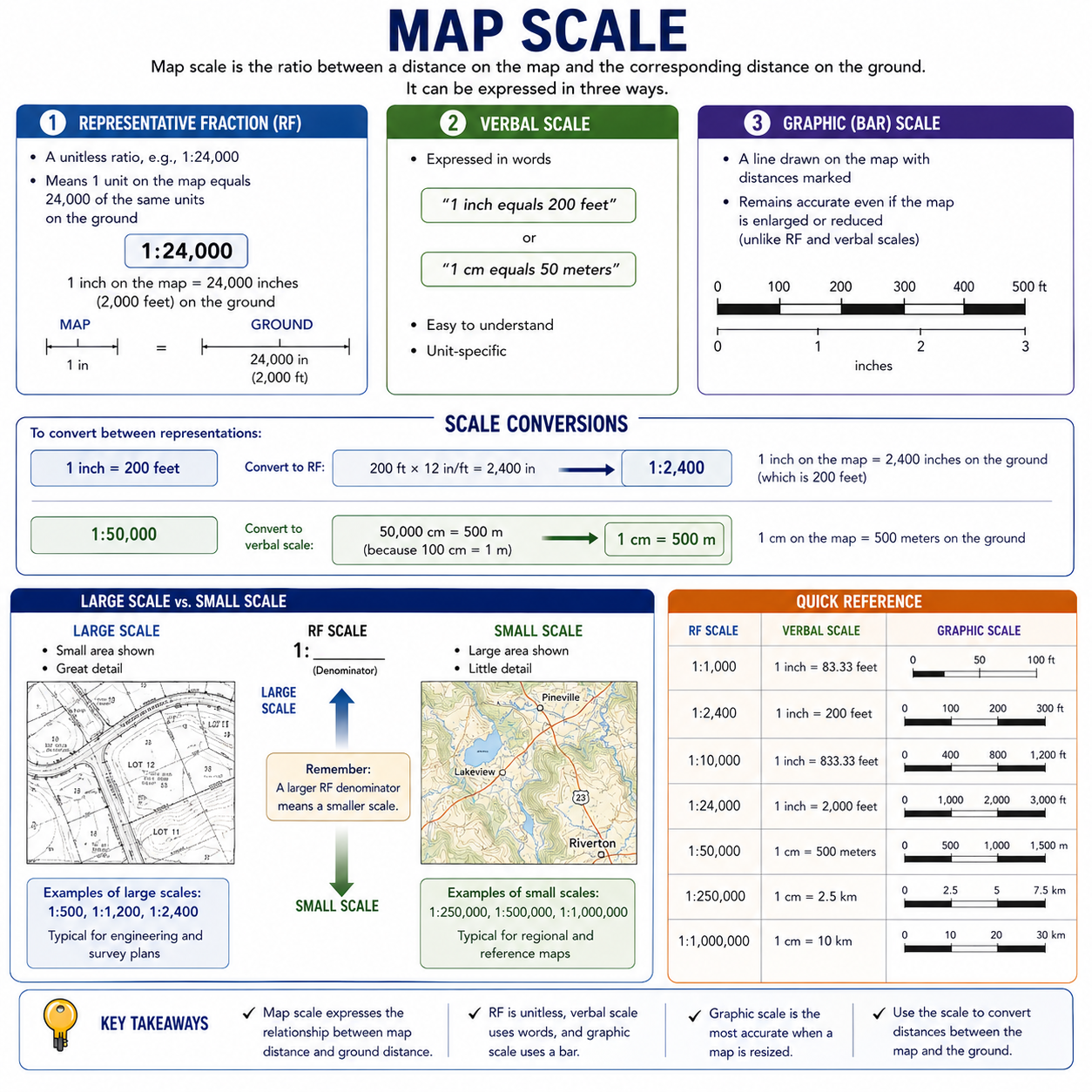
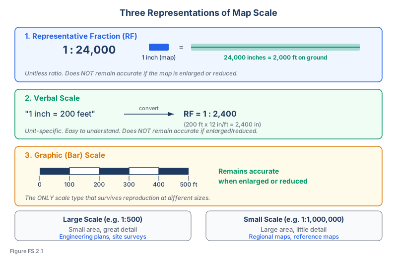
Map scale is the ratio between a distance on the map and the corresponding distance on the ground. It can be expressed in three ways:
Representative Fraction (RF):
- A unitless ratio, e.g., 1:24,000
- Means 1 unit on the map equals 24,000 of the same units on the ground
- 1 inch on the map = 24,000 inches (2,000 feet) on the ground
Verbal scale:
- Expressed in words: "1 inch equals 200 feet" or "1 cm equals 50 meters"
- Easy to understand but unit-specific
Graphic (bar) scale:
- A line drawn on the map with distances marked
- Remains accurate even if the map is enlarged or reduced (unlike RF and verbal scales)
Scale conversions:
To convert between representations:
- 1 inch = 200 feet is equivalent to 1:2,400 (because 200 ft x 12 in/ft = 2,400 in)
- 1:50,000 means 1 cm on the map = 500 m on the ground (50,000 cm = 500 m)
Large scale vs. small scale:
- Large scale maps (e.g., 1:500, 1:1,200) show a small area with great detail -- typical for engineering and survey plans
- Small scale maps (e.g., 1:250,000, 1:1,000,000) show a large area with little detail -- typical for regional and reference maps
- Remember: a larger RF denominator means a smaller scale
National Map Accuracy Standards (NMAS)
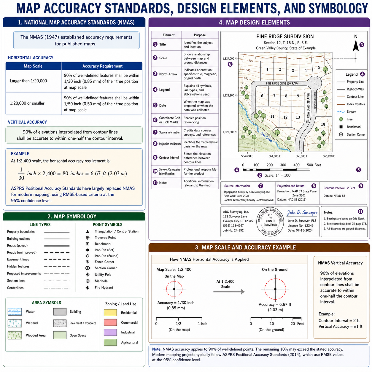
The NMAS (1947) established accuracy requirements for published maps:
Horizontal accuracy:
- For maps at scales larger than 1:20,000: 90% of well-defined features shall be within 1/30 inch (0.85 mm) of their true position at map scale
- For maps at scales of 1:20,000 or smaller: 90% within 1/50 inch (0.5 mm)
Vertical accuracy:
- Not more than 10% of elevations tested shall be in error by more than one-half the contour interval, and none can exceed the interval (Ghilani & Wolf, Elementary Surveying 13th ed., p. 506)
Example: At 1:2,400 scale, the horizontal accuracy requirement is:
- 1/30 inch x 2,400 = 80 inches = 6.67 ft (2.03 m)
ASPRS Positional Accuracy Standards for Digital Geospatial Data (Edition 2, 2023) have largely replaced NMAS for modern mapping, using RMSE-based criteria at the 95% confidence level.
Map Design Elements
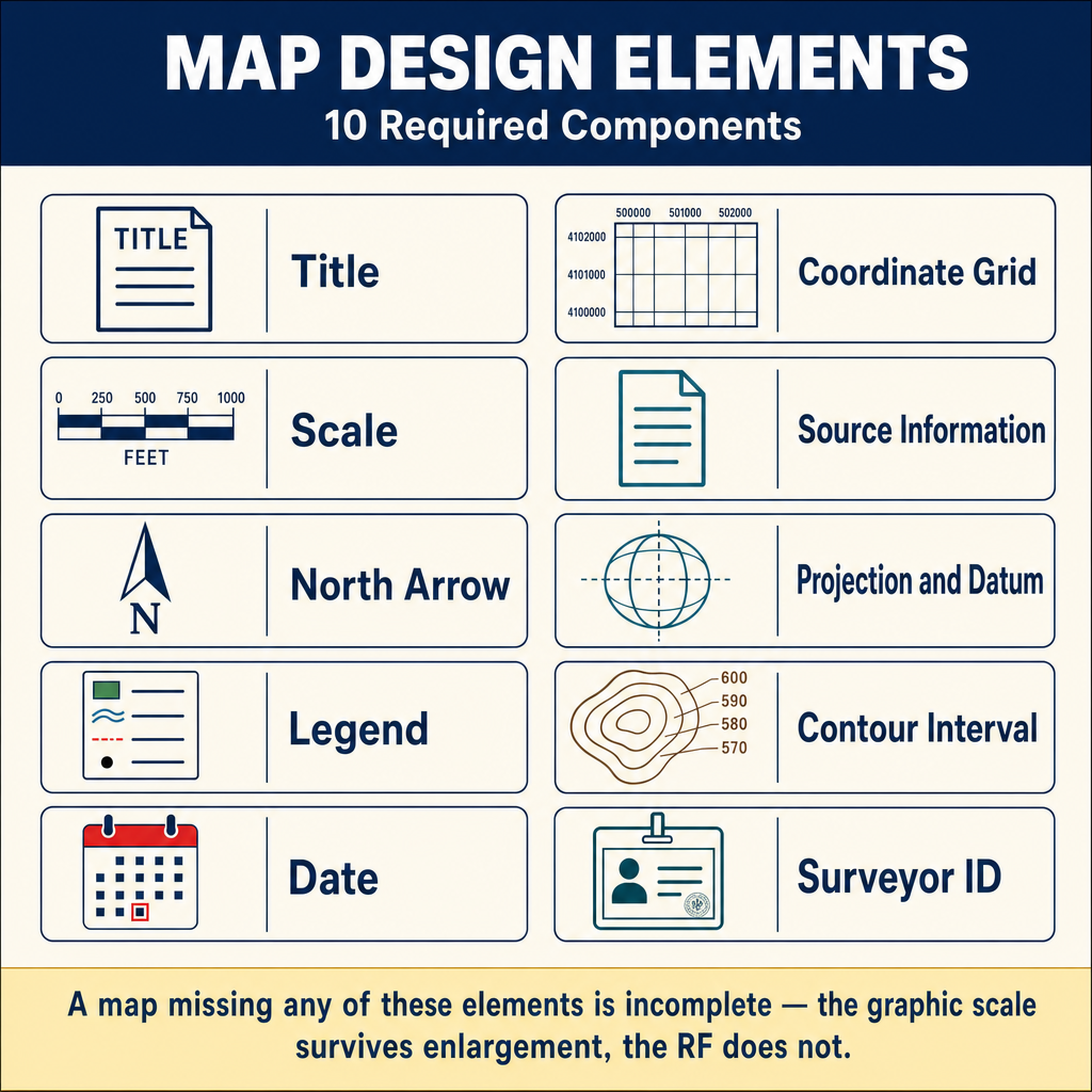
A complete, professional map should include:
| Element | Purpose |
|---|---|
| Title | Identifies the subject and location |
| Scale | Shows the relationship between map and ground distances |
| North arrow | Indicates orientation; specifies true, magnetic, or grid north |
| Legend | Explains all symbols, line types, and abbreviations used |
| Date | When the map was prepared or when the data was collected |
| Coordinate grid or tick marks | Enables position referencing |
| Source information | Credits data sources, surveys, and references |
| Projection and datum | Identifies the mathematical basis for the map |
| Contour interval | States the elevation difference between contour lines |
| Surveyor/cartographer identification | Professional responsible for the product |
Map Symbology
Standard survey and topographic maps use established symbology conventions:
Line types:
- Solid lines: Property boundaries, building outlines, roads
- Dashed lines: Hidden features, easement lines, proposed improvements
- Dotted lines: Section lines, fence lines
- Dash-dot-dash: Centerlines
Point symbols:
- Triangles: Triangulation/control stations
- Circles with cross: Traverse points
- Squares: Benchmarks
- Various symbols for trees, utility poles, manholes, fire hydrants, etc.
Area symbols:
- Hatch patterns for water, wetlands, wooded areas
- Color fills for zoning, land use, or soil types
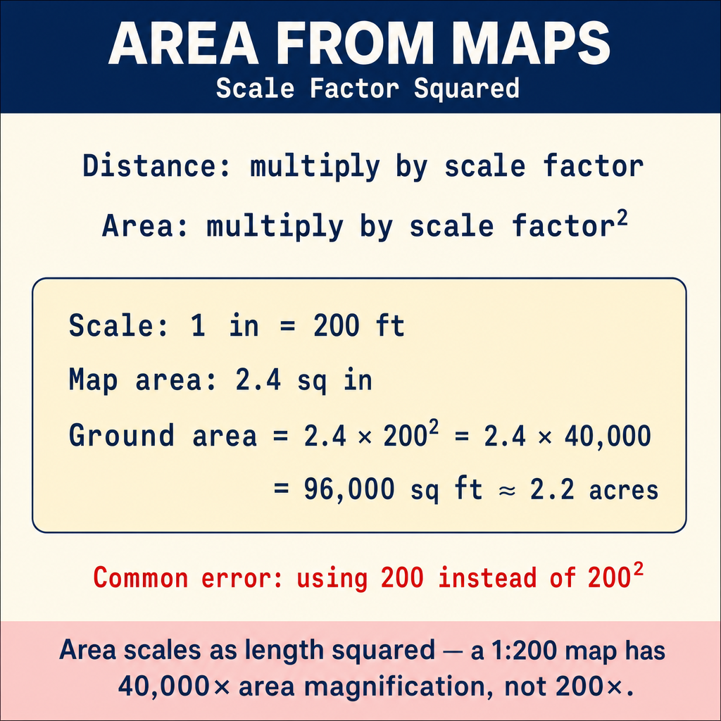
Common wrong path — scaling area by the linear scale factor. When computing ground area from a measured map area, students frequently multiply by the linear scale factor (e.g., 200 for a 1"=200' map) instead of the squared scale factor (200² = 40,000). The correct relationship: linear map dimensions scale by the scale factor; area scales by the square of the scale factor. A map area of 2 square inches at 1"=100' is 2 × 100² = 20,000 sq ft, NOT 2 × 100 = 200 sq ft. This is a fundamental mathematical property (area scales as length squared) but it trips students on the exam regularly. Similarly, volume would scale as length cubed — so a model-space cubic foot at a 1:100 model scale represents 100³ = 1,000,000 cubic feet of ground. Always cube or square the scale factor as appropriate for the dimension of the measurement.
Quick retrieval check — try before reading on.
▶A subdivision plat at 1"=60' shows a lot with a measured area of 5.5 square inches. What is the ground area in square feet and in acres?
Scale factor for area = 60² = 3,600 sq ft per sq inch.
Ground area = 5.5 sq in × 3,600 sq ft/sq in = 19,800 sq ft.
In acres: 19,800 / 43,560 = 0.454 acres (about 0.45 acre).
Common mistakes:
- Multiplying by 60 linearly: 5.5 × 60 = 330 sq ft (wrong by factor of 60 — represents what a 5.5-inch long line would be, not an area)
- Forgetting to convert to acres: 19,800 sq ft without the acre conversion leaves the answer in a less useful unit for property comparisons
Area scales as the square of the linear scale factor; volume would scale as the cube. This is not a surveying convention — it is basic geometry.
Calculating Ground Distances and Areas from Maps
Distance: Measure the map distance, then multiply by the scale factor.
- Map distance: 3.5 inches; Scale: 1 inch = 100 feet
- Ground distance: 3.5 x 100 = 350 feet
Area: Map areas scale by the square of the scale factor.
- Map area: 2.4 square inches; Scale: 1 inch = 200 feet
- Ground area: 2.4 x (200)^2 = 2.4 x 40,000 = 96,000 sq ft (approximately 2.2 acres)
Exam Tips
- Large scale = large detail, small area (e.g., 1:500); small scale = small detail, large area (e.g., 1:1,000,000)
- When converting scale, keep units consistent -- convert feet to inches or meters to centimeters as needed
- A graphic (bar) scale remains accurate when the map is enlarged or reduced; an RF does not
- NMAS horizontal accuracy is 1/30 inch at map scale for large-scale maps
- NMAS vertical accuracy is one-half the contour interval
- Area scales by the square of the linear scale factor -- this is a common exam calculation
- Know the standard map elements (title, scale, north arrow, legend, date)
- The FS exam may give you a map scale and ask you to calculate ground distance or area
Related Test Topics
- Plan and Profile Drawings (Topic 2.2)
- GIS and Spatial Analysis (Topic 2.5)
- Map Projections and Grids (Module 4, Topic 4.7)
- State Plane Coordinates (Module 4, Topic 4.6)
Further Reading
Authoritative sources for deeper study
Snyder, USGS Bulletin 1532 — Map Projections Used by the USGS — Mathematical treatment of common map projections (Lambert Conformal Conic, Transverse Mercator, etc.).
Penn State GEOG 482 — The Nature of Geographic Information — Open courseware on map projections, datums, and geospatial data fundamentals.
NOAA Manual NOS NGS 5 — State Plane Coordinate System of 1983 — Definitive NGS reference for SPCS83 zone constants, projections, and conversions.
Wolf & Ghilani, Elementary Surveying — Chapter on map projections and the State Plane Coordinate System.
Last updated: 2026-04-17