FS Exam Preparation
Comprehensive preparation for the Fundamentals of Surveying (FS) exam. 7 modules covering all 7 exam domains with 60 in-depth topics.
Module 1: Surveying Processes & Methods
Module 2: Mapping Processes & Methods
Module 3: Boundary Law & Real Property
Module 4: Surveying Principles & Geodesy
Module 5: Survey Computations
Module 6: Business Concepts
Remote Sensing, LiDAR & UAS
Learning Objectives
After completing this topic, you should be able to:
- Define remote sensing and its basic principles
- Explain how LiDAR works and its applications in surveying
- Describe UAS (drone) surveying fundamentals and regulations
- Distinguish between passive and active remote sensing
- Understand point cloud data and its processing
- Identify the advantages and limitations of each technology
Overview
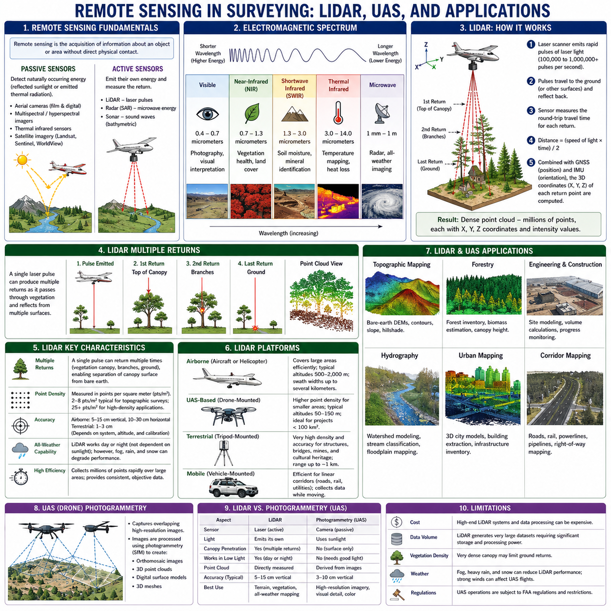
Remote sensing is the acquisition of information about an object or area without direct physical contact. In surveying, remote sensing technologies -- particularly LiDAR (Light Detection and Ranging) and UAS (Unmanned Aircraft Systems, commonly called drones) -- have become essential tools for efficient, high-density data collection. These technologies complement traditional ground-based surveying and photogrammetry.
The FS exam tests your understanding of how these technologies work, their applications, and their limitations.
Key Concepts
Remote Sensing Fundamentals
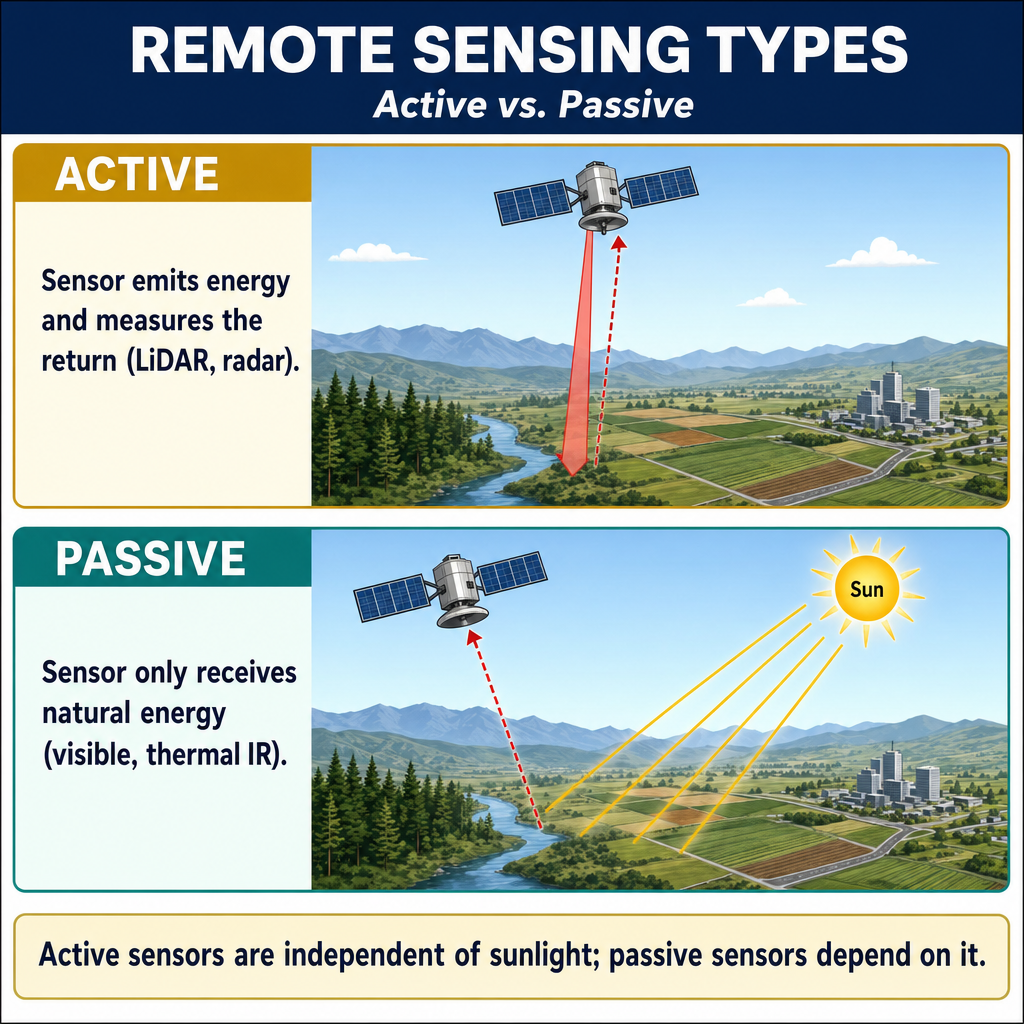
Remote sensing systems are classified as passive or active:
Passive sensors detect naturally occurring energy (usually reflected sunlight or emitted thermal radiation):
- Aerial cameras (film and digital)
- Multispectral and hyperspectral imagers
- Thermal infrared sensors
- Satellite imagery (Landsat, Sentinel, WorldView)
Active sensors emit their own energy and measure the return:
- LiDAR -- emits laser pulses and measures the return time
- Radar (SAR) -- emits microwave energy and measures the return
- Sonar -- emits sound waves (used in bathymetric surveying)
Electromagnetic Spectrum
Remote sensing relies on the electromagnetic spectrum:
| Band | Wavelength Range | Application |
|---|---|---|
| Visible | 0.4 - 0.7 micrometers | Photography, visual interpretation |
| Near-infrared (NIR) | 0.7 - 1.3 micrometers | Vegetation health, land cover |
| Shortwave infrared (SWIR) | 1.3 - 3.0 micrometers | Soil moisture, mineral identification |
| Thermal infrared | 3.0 - 14.0 micrometers | Temperature mapping, heat loss |
| Microwave | 1 mm - 1 m | Radar, all-weather imaging |
LiDAR (Light Detection and Ranging)
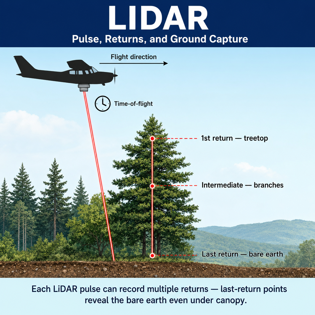
How LiDAR works:
- A laser scanner emits rapid pulses of laser light (typically 100,000 to 1,000,000+ pulses per second)
- The pulses travel to the ground (or other surfaces) and reflect back to the sensor
- The sensor measures the round-trip travel time for each pulse
- Using the speed of light, the distance to each reflection point is calculated
- Combined with the sensor's known position (from GNSS) and orientation (from an Inertial Measurement Unit, IMU), the 3D coordinates of each reflection point are computed
The result: A dense point cloud -- millions of points, each with X, Y, Z coordinates and intensity values.
Key LiDAR characteristics:
- Multiple returns: A single pulse can produce multiple returns as it passes through vegetation canopy, hits branches, and reaches the ground -- enabling separation of canopy surface from bare earth
- Point density: Measured in points per square meter; 2-8 pts/sq m is typical for topographic surveys; 25+ pts/sq m for high-density applications
- Accuracy: Typically 5-15 cm vertical, 10-30 cm horizontal for airborne systems; 1-3 cm for terrestrial systems (consistent with USGS Lidar Base Specification v2.1 (2020) and ASPRS LiDAR guidelines)
- All-weather capability: LiDAR works day or night (not dependent on sunlight); however, fog, rain, and snow can degrade performance
LiDAR platforms:
- Airborne (aircraft or helicopter): Covers large areas efficiently
- UAS-based (drone-mounted): Higher density for smaller areas
- Terrestrial (tripod-mounted): Very high density for structures, bridges, mines
- Mobile (vehicle-mounted): Efficient for linear corridors (roads, rail)
Point Cloud Processing
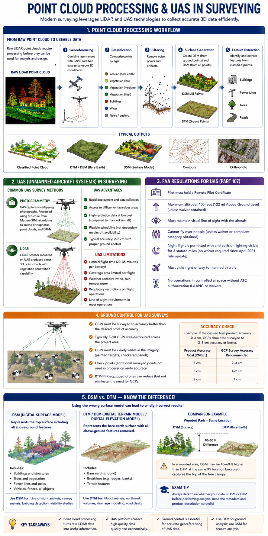
Raw LiDAR point clouds require processing before use:
- Georeferencing: Combining laser ranges with GNSS and IMU data to compute 3D coordinates
- Classification: Categorizing points by type:
- Ground (bare earth)
- Vegetation (low, medium, high)
- Buildings
- Water
- Noise/outliers
- Filtering: Removing noise points and artifacts
- Surface generation: Creating DTMs (from ground points) and DSMs (from all points)
- Feature extraction: Identifying buildings, power lines, trees from classified points
UAS (Unmanned Aircraft Systems) in Surveying
UAS (commonly called drones) have become a standard surveying tool for efficient data collection over small to medium-sized areas.
Common UAS survey methods:
- Photogrammetry: Camera-equipped UAS captures overlapping photographs; processed using Structure from Motion (SfM) algorithms to create orthophotos, point clouds, and DTMs
- LiDAR: LiDAR scanner mounted on UAS; produces direct 3D point clouds with vegetation penetration capability
UAS advantages:
- Rapid deployment and data collection
- Access to difficult or hazardous areas
- High-resolution data at low cost (compared to manned aircraft)
- Flexible scheduling (not dependent on aircraft availability)
- Typical accuracy: 2-5 cm with proper ground control
UAS limitations:
- Limited flight time (typically 20-45 minutes per battery)
- Coverage area limited per flight
- Weather sensitive (wind, rain, temperature)
- Regulatory restrictions on flight operations
- Line-of-sight requirement in most operations
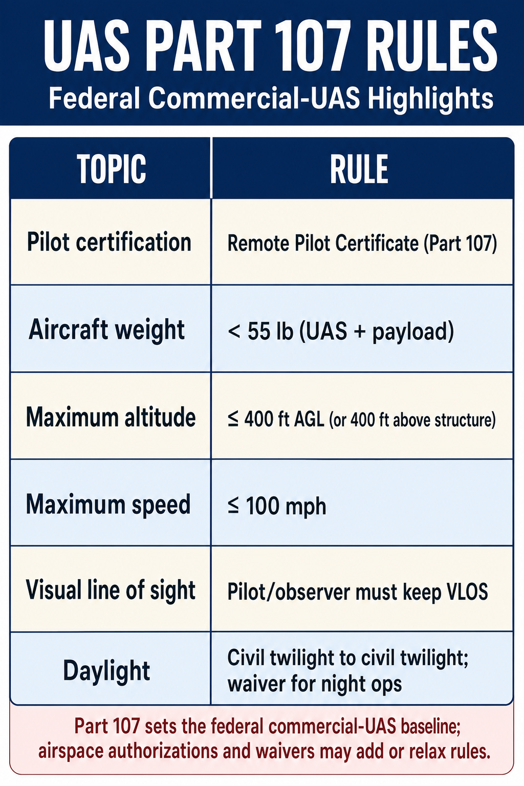
FAA regulations for commercial UAS operations (Part 107):
- Pilot must hold a Remote Pilot Certificate
- Maximum altitude: 400 feet (122 m) AGL (unless waiver obtained)
- Must maintain visual line of sight with the aircraft
- Cannot fly over people (unless waiver or compliant category obtained)
- Night flight is permitted under the April 2021 Part 107 amendments, provided the aircraft has anti-collision lighting visible for at least 3 statute miles (no separate waiver required)
- Must yield right-of-way to manned aircraft
- No operations in controlled airspace without ATC authorization (LAANC or waiver)
Common wrong path — treating DSM and DTM as interchangeable. A Digital Surface Model (DSM) includes the tops of trees, buildings, power lines, and other above-ground features. A Digital Terrain Model / Digital Elevation Model (DTM/DEM) represents the bare-earth surface with all those features removed. For a wooded park, the DSM might show elevations 40–60 ft higher than the DTM at the same XY location — because the top of the tree canopy is captured in DSM, while the ground is captured in DTM. Students (and junior GIS staff) sometimes download "LiDAR elevation data" without checking which product they have, then compute volumes, drainages, or floodplains against the wrong surface. The result: wildly wrong analyses. Exam questions test this by describing a product labeled ambiguously ("elevation data from LiDAR") and asking whether it's appropriate for a specific task — if the task requires ground elevation (flood analysis, earthwork, road design), DTM is needed; if it requires feature heights (canopy analysis, building detection), DSM is needed.
Quick retrieval check — try before reading on.
▶A project requires cut-and-fill earthwork estimates for a forested 50-acre parcel. A LiDAR dataset is available that includes "first return" elevations classified as "all returns." Can this dataset be used directly for earthwork analysis? If not, what must be done?
Not directly. "First return" elevations capture the highest reflecting surface encountered by each pulse — for a forested parcel, that's the top of the canopy, not the ground. Using these elevations as if they were ground elevations would overestimate existing ground by 40+ ft across the wooded areas, producing cut quantities that are wildly wrong (and fill quantities that are correspondingly wrong).
Required: extract last returns that were classified as ground (typically class 2 in the ASPRS classification scheme). These points reached the bare earth under the canopy. Build a TIN (with breaklines along ridges, valleys, stream banks) from the ground-classified points; that TIN is the DTM used for earthwork. LiDAR's ability to separate ground from canopy using multiple returns is the entire reason it's useful in forested areas — but only if the ground classification was actually performed. If the dataset has "all returns" without a classified ground surface, you need to either run a classification workflow (ArcGIS, LAStools, or similar) or request a classified product from the data provider.
Ground Control for UAS Surveys
UAS surveys require ground control points (GCPs) for accurate georeferencing:
- GCPs must be surveyed to accuracy better than the desired product accuracy
- Typically 5-10 GCPs well-distributed across the project area
- GCPs must be clearly visible in the imagery (painted targets, checkered panels)
- Check points (additional surveyed points not used in processing) verify accuracy
- RTK/PPK-equipped drones can reduce (but not eliminate) the need for GCPs
Exam Tips
- LiDAR is an active sensor (emits its own energy); cameras are passive sensors
- Multiple returns from a single LiDAR pulse allow separation of vegetation from ground surface
- Point cloud classification separates ground, vegetation, buildings, and other features
- UAS operations under FAA Part 107 require a Remote Pilot Certificate and have a 400 ft AGL altitude limit
- Ground control points are essential for accurate UAS survey products
- LiDAR accuracy is typically 5-15 cm vertical for airborne systems; terrestrial LiDAR achieves 1-3 cm
- UAS photogrammetry uses Structure from Motion (SfM) to create 3D models from overlapping photographs
- The FS exam may test LiDAR principles, UAS regulations, or the difference between active and passive sensors
- DSM includes above-ground features; DTM/DEM represents bare earth -- LiDAR can produce both using multiple returns
Related Test Topics
- Photogrammetry Principles (Topic 2.7)
- Digital Terrain Models (Topic 2.6)
- Topographic Surveys (Module 1, Topic 1.7)
- GNSS/GPS Methods (Module 1, Topic 1.3)
Further Reading
Authoritative sources for deeper study
Wolf, DeWitt & Wilkinson, Elements of Photogrammetry with Applications in GIS (4th Ed.) — Standard photogrammetry text covering geometry, stereo models, and aerotriangulation.
Penn State GEOG 482 — The Nature of Geographic Information — Open courseware on map projections, datums, and geospatial data fundamentals.
FGDC Geospatial Positioning Accuracy Standards — National standard for positional accuracy reporting (NSSDA).
Last updated: 2026-04-17