FS Exam Preparation
Comprehensive preparation for the Fundamentals of Surveying (FS) exam. 7 modules covering all 7 exam domains with 60 in-depth topics.
Module 1: Surveying Processes & Methods
Module 2: Mapping Processes & Methods
Module 3: Boundary Law & Real Property
Module 4: Surveying Principles & Geodesy
Module 5: Survey Computations
Module 6: Business Concepts
Plats, Record of Survey & ALTA Maps
Learning Objectives
After completing this topic, you should be able to:
- Describe the components and purpose of a subdivision plat
- Explain the function of a survey-record document (recorded boundary survey map) and recognize that the document name and recording trigger vary by state
- Understand the ALTA/NSPS Land Title Survey standards (national)
- Identify the optional Table A items on an ALTA survey
- Distinguish between the different types of recorded survey documents by their legal function (creating parcels vs. documenting evidence vs. supporting title)
- Describe the surveyor's certification requirements
Overview
Surveyors produce several types of formal documents that become part of the public record or serve as legal evidence of property boundaries. Three broad categories are tested on the FS exam:
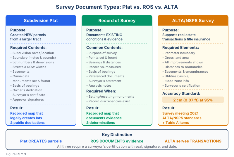
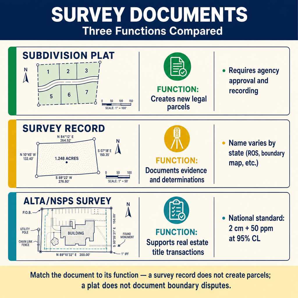
- Subdivision plats — recorded maps that create new legal parcels by dividing a larger tract.
- Survey records / boundary survey maps — recorded or filed maps that document a surveyor's evidence, measurements, and boundary determinations. The exact name of this document varies by state (Record of Survey, Boundary Survey Map, Land Survey, Surveyor's Report, Filed Map, etc.).
- ALTA/NSPS Land Title Surveys — surveys prepared to a specific national standard (the Minimum Standard Detail Requirements) for real estate transactions and title insurance.
Important for the FS exam: The exact document names, recording procedures, and triggers for when each is required vary substantially from state to state. Where this lesson uses generic terminology, focus on the function each document performs (creates parcels vs. documents evidence vs. supports a title transaction) rather than memorizing any single state's terminology. The ALTA/NSPS standard is the only one of the three that is genuinely national and tested in detail on the FS exam.
Key Concepts
Subdivision Plats
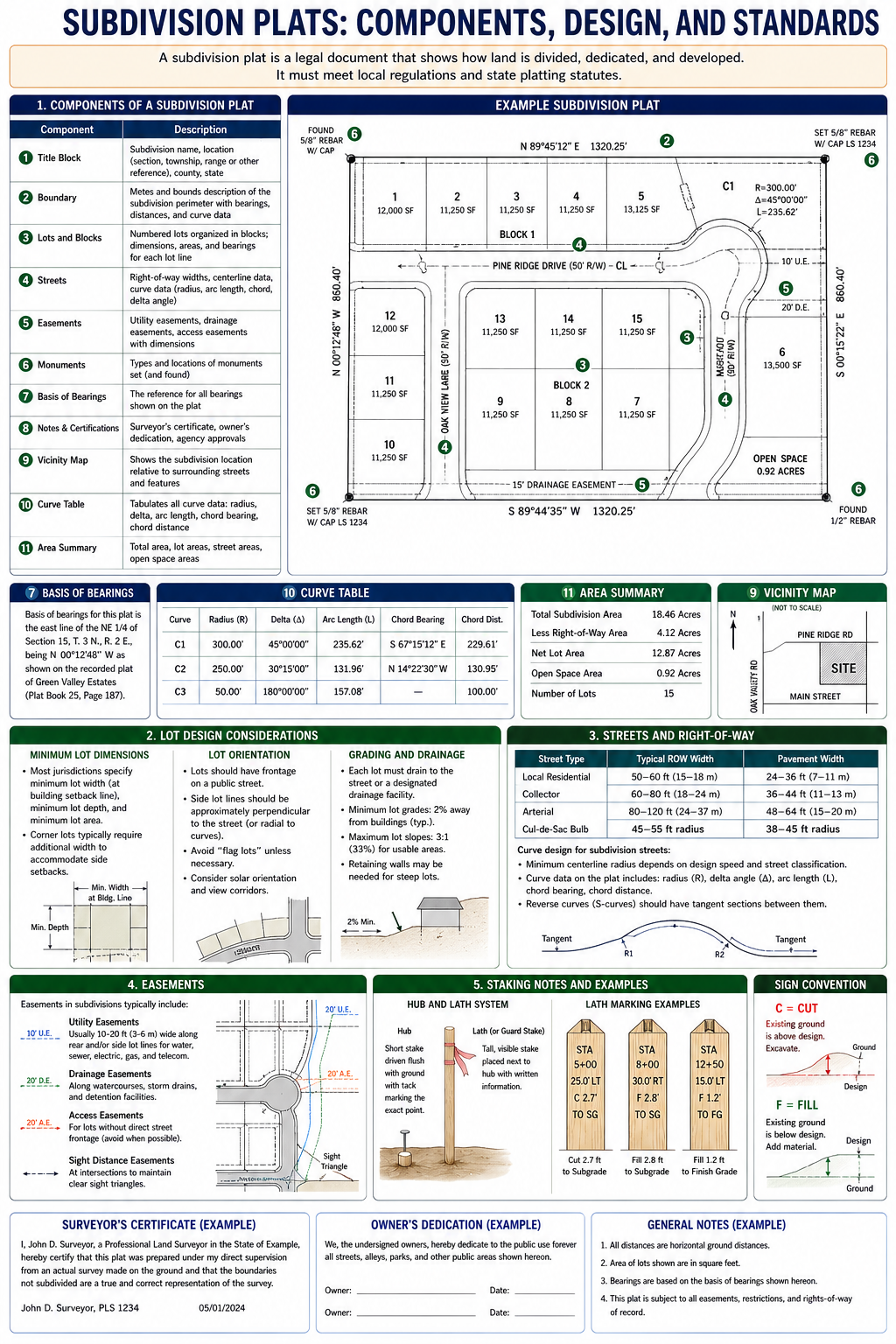
A subdivision plat (or subdivision map) is a recorded map that divides land into lots, blocks, and streets. Recording the plat creates the legal parcels.
Required components (vary by jurisdiction but typically include):
- Subdivision name and location
- Boundary of the entire subdivision with metes and bounds
- Lot numbers, block designations, and dimensions for all lots
- Street names, right-of-way widths, and centerline geometry
- Easements with widths and purposes
- Curve data (radius, arc length, chord bearing, chord distance, delta angle)
- Monuments set and found, with descriptions
- Basis of bearings
- Scale and north arrow
- Owner's dedication of streets and easements
- Surveyor's certificate
- Approval signatures (planning commission, city council, county recorder)
- Title report reference or certificate of title
Accuracy requirements:
- Most jurisdictions require minimum angular and linear closure standards
- Boundary dimensions must be sufficient to mathematically close the lots and blocks
Survey Records / Boundary Survey Maps
Many states require surveyors to record (or file) a map documenting the results of a boundary survey when certain conditions are met. The document name varies by state -- common names include Record of Survey, Boundary Survey Map, Land Survey, Survey Map, Filed Map, Surveyor's Map, and Surveyor's Report. Whatever it is called locally, the document's function is the same: it documents the survey, not the creation of new parcels.
Key distinction from a subdivision plat: a survey record documents evidence, measurements, and boundary determinations. It does not create new legal parcels. A subdivision plat does the opposite: it creates new parcels but is generally not the document used to memorialize evidence-based boundary determinations.
Triggers for recording a survey map (vary substantially by state -- check the state's licensing statute):
- Setting or resetting boundary monuments
- Establishing boundary lines not previously shown on a recorded map
- Discrepancies between the record description and field conditions
- Boundary establishment, reestablishment, or retracement work
- Many states have statutory triggers; others rely on professional judgment
Common contents (regardless of state-specific name):
- Purpose of the survey
- Points set and found, with descriptions
- Bearings and distances of surveyed lines
- Relationship to record data (showing any discrepancies)
- Basis of bearings
- References to record documents (deeds, plats, prior surveys)
- Surveyor's statement or certificate
- Notes explaining the surveyor's analysis and determinations
National-exam framing: Unlike ALTA/NSPS, there is no national standard for survey-record documents. Several states have no recording requirement at all; others have detailed statutory requirements. The FS exam tests the concept (documenting evidence vs. creating parcels) rather than any one state's specific procedure or document name.
ALTA/NSPS Land Title Surveys
The ALTA/NSPS Land Title Survey is prepared in accordance with the Minimum Standard Detail Requirements jointly published by the American Land Title Association (ALTA) and the National Society of Professional Surveyors (NSPS). The current standards are the 2026 Minimum Standard Detail Requirements (effective February 23, 2026), which supersede the 2021 standards.
Purpose: ALTA surveys are used in commercial real estate transactions to provide title insurance companies, lenders, and buyers with detailed information about the property boundaries, improvements, easements, and encumbrances.
Key requirements:
Positional accuracy:
- Relative positional precision not to exceed 2 cm (0.07 ft) plus 50 ppm at the 95% confidence level (based on the direct distance between the two corners being tested)
- This applies to the boundary points relative to each other
Required elements:
- Perimeter boundary with bearings, distances, and curve data
- Gross land area
- All improvements (buildings, structures, paved areas) with measured distances to boundary lines
- All visible easements and evidence of easements
- Rights-of-way, alleys, and access
- Evidence of utilities (above and below ground)
- Parking areas and spaces (if Table A Item 6 is selected)
- Flood zone designation with reference to FEMA map
- Surveyor's certification
ALTA Table A Optional Items
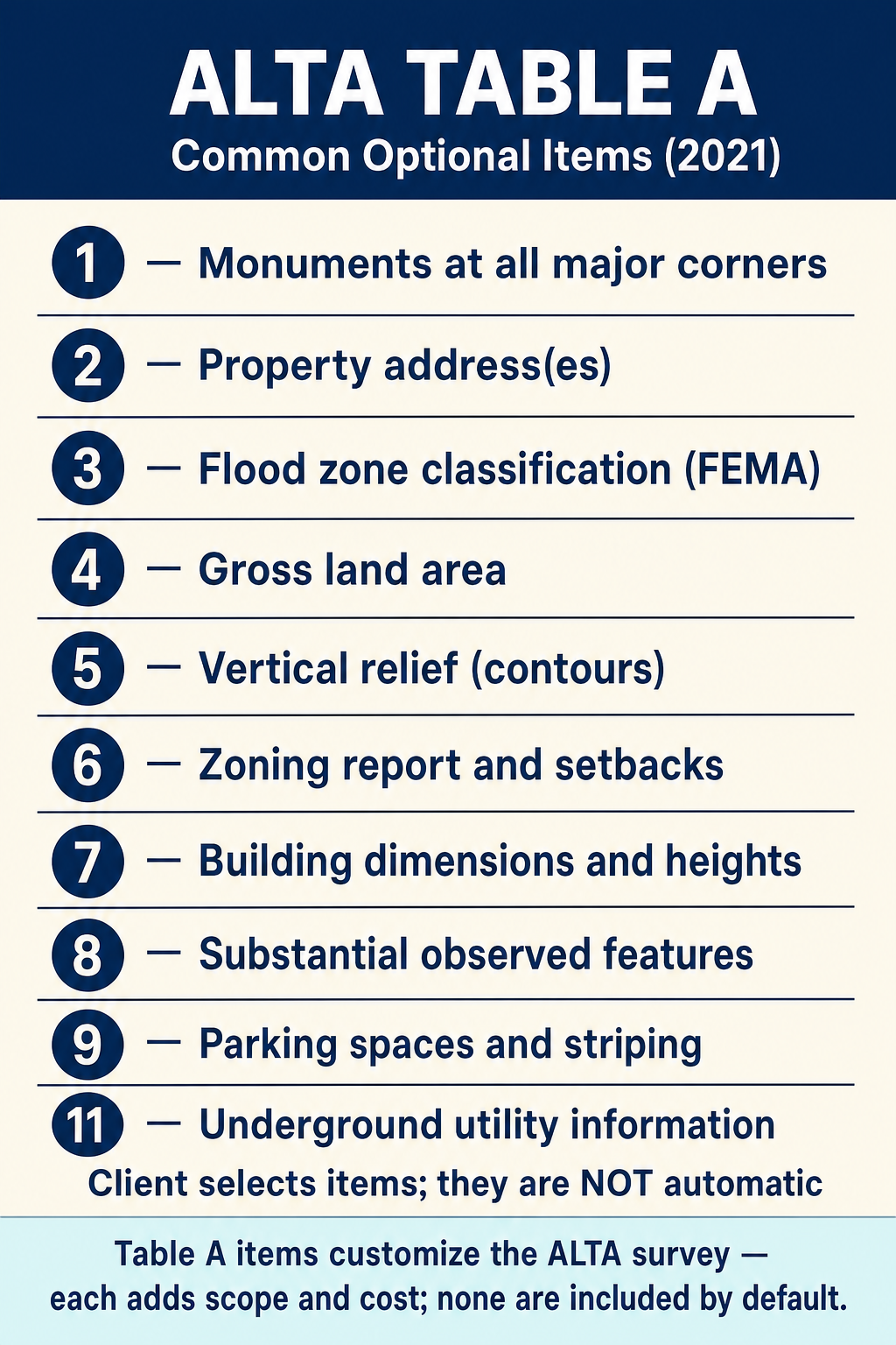
The client selects Table A items to customize the ALTA survey. Common optional items include:
| Item | Description |
|---|---|
| 1 | Monuments placed (or reference monument/witness) at all major boundary corners not already marked |
| 2 | Address(es) of the surveyed property if disclosed in documents or observed during fieldwork |
| 3 | Flood zone classification (FEMA FIRM or state/local equivalent) — depicted by scaled map location only |
| 4 | Gross land area, plus other areas if specified by the client |
| 5 | Vertical relief — source, contour interval, datum, originating benchmark when appropriate |
| 6(a)/(b) | Zoning — (a) full zoning report items (classification, setbacks, height, FAR, parking) listed from a client-provided report; (b) graphical depiction of setback requirements |
| 7(a)/(b)/(c) | Buildings — (a) exterior dimensions at ground level; (b) square footage of footprints/other client-specified areas; (c) measured height above grade |
| 8 | Substantial observed features beyond base requirements (parking lots, billboards, signs, swimming pools, landscaping, refuse, etc.) |
| 9 | Number and type of clearly identifiable parking spaces; striping in surface lots |
| 10 | Division/party walls — relationship and location with adjoining properties |
| 11(a)/(b) | Underground utilities — (a) plans/reports from client; (b) markings from a private utility locate request |
| 12 | Governmental agency survey-related requirements (HUD, BLM-managed leases, etc.) — client supplies the requirements |
| 13 | Names of owners of adjoining properties per current tax records ("et al." after the first listed owner if multiple) |
| 14 | Distance to nearest intersecting street, as specified by the client |
| 15 | Imagery used as the basis for showing non-boundary features in close proximity to the boundary — written agreement on source/date/version/licensing, ramifications discussion with insurer/lender/client, and face-of-survey note required (rewritten in 2026) |
| 16 | Evidence of recent earth moving, building construction, or building additions observed during fieldwork |
| 17 | Proposed changes in street ROW (if made available by the controlling jurisdiction); plus evidence of recent street/sidewalk construction |
| 18 | Plottable offsite (appurtenant) easements disclosed in documents provided to or obtained by the surveyor |
| 19 | Professional liability insurance — client-specified minimum amount; certificate furnished on request; not addressed on the plat |
| 20 | Potential encroachment summary table (NEW defined item in 2026) — face-of-plat table summarizing potential boundary encroachments (both directions), encroachments into documented rights-of-way/easements, setback encroachments where setbacks were provided, physical access between adjoining parcels without a documented easement, and use of adjoining parcels by occupants without a documented easement |
| 21 | Blank/custom slot for negotiated additional items — 21(a), 21(b), etc. (this slot was Item 20 in the 2021 standard) |
Common wrong path — confusing subdivision plat with a survey record / boundary survey map. Both are recorded survey documents, both bear a surveyor's seal, and both can look similar on paper — but they do fundamentally different things:
- Subdivision plat creates new legal parcels by dividing a larger parcel into lots. It is a land-division instrument that typically requires local-agency approval, dedications of streets and easements, and compliance with subdivision ordinances.
- Survey record / boundary survey map documents existing conditions, found evidence, and the surveyor's boundary determinations. It does NOT create new parcels — recording or filing a survey map typically is not a land-division act.
Students sometimes assume any recorded survey document can divide land, or that a survey map automatically creates the parcels it shows. Wrong. On the exam, a scenario that asks "which document is required to create five new parcels" is a subdivision question (subdivision plat or whatever the state calls its land-division instrument). A scenario that asks "which document is required when the surveyor finds discrepancies between field evidence and the recorded plat" is a survey-record question. Match the document to its legal function.
Quick retrieval check — try before reading on.
▶A surveyor is retracing a residential property where the client wants to split their lot into two parcels and also resolve a dispute with the neighbor about a fence line. Which document(s) are required?
Two different documents for two different purposes:
-
A subdivision plat (the specific name varies by state) to create the two parcels. This generally requires local-agency approval, compliance with zoning and subdivision ordinances, and recording with the appropriate authority. The surveyor alone cannot split the lot — agency approval is required.
-
A survey record / boundary survey map (whatever the state calls it — Record of Survey, Boundary Survey Map, Land Survey, etc.) to document the fence-line discrepancy and the surveyor's boundary determination. In most states with such a requirement, this does not need agency approval to record; it captures the surveyor's analysis of field evidence versus record.
Both may be recorded. Neither substitutes for the other. A student who answers "just the survey record" misses the parcel-creation function; a student who answers "just the subdivision plat" misses the need to document the boundary-evidence dispute. The exam sometimes forces a single answer — in that case pick the one that matches the specific fact the question is asking about, but understand that the full project involves both.
Surveyor's Certification
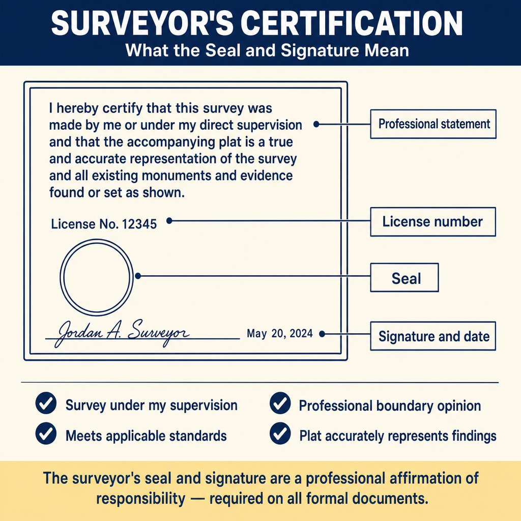
All formal survey documents include a surveyor's certificate -- a signed and sealed statement affirming:
- The survey was performed under the surveyor's supervision
- The survey meets applicable standards
- The boundary determination is the surveyor's professional opinion
- The plat or map accurately represents the survey findings
The certification language varies by state but typically includes the surveyor's name, license number, seal, signature, and date.
Exam Tips
- A subdivision plat creates new parcels; a survey-record document documents existing conditions and evidence — focus on the function, not the document's local name
- Document names for survey-record maps vary by state (Record of Survey, Boundary Survey Map, Land Survey, Surveyor's Report, Filed Map, etc.); the FS exam tests the concept, not any one state's terminology
- The ALTA/NSPS 2026 standards require a relative positional precision of 2 cm (0.07 ft) plus 50 ppm at 95% confidence — this is the only one of the three documents with a national, exam-quotable accuracy standard (the 2 cm + 50 ppm value is unchanged from 2021)
- Table A items are optional and must be specifically requested by the client
- Know the basic components of a subdivision plat (boundary, lots, streets, easements, monuments, certifications)
- ALTA surveys require showing the relationship of all improvements to boundary lines (measured distances)
- The surveyor's certification is a professional statement of responsibility; it is required on all formal survey documents
- Flood zone information is commonly required on ALTA surveys (Table A Item 3)
Related Test Topics
- Land Development and Subdivisions (Module 1, Topic 1.9)
- Cadastral and Boundary Surveys (Module 1, Topic 1.6)
- Metes and Bounds Descriptions (Module 3, Topic 3.6)
- Public Records and Descriptions (Module 3, Topic 3.1)
Further Reading
Authoritative sources for deeper study
2026 ALTA/NSPS Land Title Survey Standards — Current minimum standard detail requirements for ALTA/NSPS land title surveys (effective February 23, 2026).
Wattles, Writing Legal Descriptions (1976) — Gold-standard reference on metes-and-bounds, sectional, and combination descriptions.
Brown's Boundary Control and Legal Principles (7th Ed., Robillard & Wilson) — Standard textbook on boundary law, evidence hierarchy, and retracement.
Wolf & Ghilani, Elementary Surveying — An Introduction to Geomatics (13th Ed., 2012) — Comprehensive surveying text covering instruments, field procedures, and computations.
Last updated: 2026-05-30