FS Exam Preparation
Comprehensive preparation for the Fundamentals of Surveying (FS) exam. 7 modules covering all 7 exam domains with 60 in-depth topics.
Module 1: Surveying Processes & Methods
Module 2: Mapping Processes & Methods
Module 3: Boundary Law & Real Property
Module 4: Surveying Principles & Geodesy
Module 5: Survey Computations
Module 6: Business Concepts
Slopes, Grades & Interpolation
Learning Objectives
After completing this topic, you should be able to:
- Calculate slope (grade) as a ratio, percent, and angle
- Convert between slope representations
- Perform linear interpolation for contour locations
- Compute slope staking values (cut/fill and distance)
- Determine contour intervals and interpolation points on a grid
Overview
Slopes, grades, and interpolation deal with the vertical component of surveying -- how the ground rises and falls and how that is represented on maps and in design. Surveyors must compute grades for roads and drainage, interpolate elevations between measured points, and stake proposed slopes in the field. These computations appear throughout the FS exam, often embedded in larger problems about construction layout, topographic mapping, and earthwork.
Key Concepts
Slope and Grade Representations
The same slope can be expressed in multiple ways:
| Representation | Definition | Example |
|---|---|---|
| Percent grade | (rise / run) * 100 | 5% = 5 ft rise per 100 ft run |
| Slope ratio | horizontal : vertical | 2:1 = 2 ft horizontal per 1 ft vertical |
| Angle | arctan(rise / run) | 2.86 degrees for 5% grade |
| Decimal | rise / run | 0.05 for 5% grade |
Conversions:
- Percent to decimal: divide by 100 (5% = 0.05)
- Percent to angle: angle = arctan(percent / 100) = arctan(0.05) = 2.86 degrees
- Slope ratio H:V to percent: percent = (V/H) * 100 (2:1 = 50%)
- Slope ratio H:V to angle: angle = arctan(V/H) = arctan(1/2) = 26.57 degrees
Common wrong path — slope ratio V:H vs H:V. Slope ratios are ambiguous until you fix the order. The engineering/surveying convention in the U.S. for earthwork slopes is H:V (horizontal:vertical): "2:1" means 2 ft horizontal for every 1 ft vertical. But some disciplines (highway design in some contexts, hydraulics for steep drops) write slopes V:H or as a gradient. A "2:1 slope" in H:V convention is a 50% grade (moderately steep); the same ratio read as V:H would be 200% — a wildly different thing. Before plugging into any formula, confirm which convention applies. For earthwork and roadway side slopes, assume H:V unless told otherwise. For stream gradients or railroad grades, check the context. Exam questions that write "2:1" without clarification typically mean H:V for side slopes; watch for scenarios where the convention switches mid-problem (earthwork slope vs. stream gradient in the same figure).
Quick retrieval check — try before reading on.
▶A proposed fill slope is specified at 3:1 (H:V). The toe of the fill is at elevation 98.0 ft, and the top of fill is at elevation 112.0 ft. How far horizontally is the top of the fill from the toe?
Vertical rise = 112.0 − 98.0 = 14.0 ft. With H:V = 3:1, horizontal distance per foot of rise = 3. Total horizontal = 14.0 × 3 = 42.0 ft. If you had read "3:1" as V:H (wrong convention), you'd get 14.0 ÷ 3 = 4.67 ft — a very different stakeout distance. Always verify H:V vs V:H before applying the ratio; U.S. convention for earthwork side slopes is H:V.
Horizontal vs. Slope Distance
- Horizontal distance (HD): The level distance between two points
- Slope distance (SD): The distance measured along the slope
- Vertical distance (VD): The rise or fall between two points
Relationships:
HD = SD * cos(angle)
VD = SD * sin(angle)
SD = sqrt(HD^2 + VD^2)
For small slopes (under about 10%):
HD is approximately equal to SD (the difference is negligible for most purposes)
Linear Interpolation
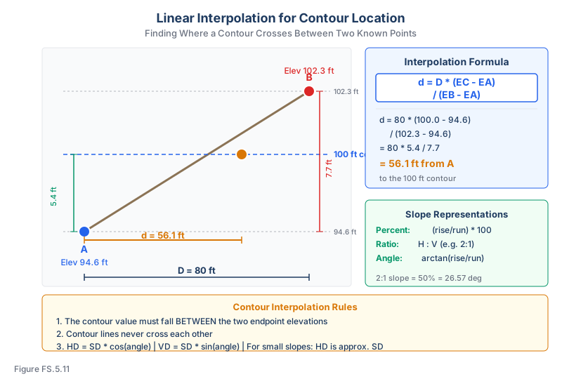
Used to find the position of a specific elevation (e.g., a contour line) between two known points.
Given points A (elevation EA) and B (elevation EB) with distance D between them, find the distance from A to the point at elevation EC:
d = D * (EC - EA) / (EB - EA)
Example: Point A has elevation 94.6 ft and Point B has elevation 102.3 ft, separated by 80 ft. Where does the 100 ft contour cross?
d = 80 * (100.0 - 94.6) / (102.3 - 94.6) = 80 * 5.4 / 7.7 = 56.1 ft from A
Contour Interpolation on a Grid
For a topographic survey grid:
- Identify grid edges where a contour value falls between the elevations of the two endpoints
- Use linear interpolation to find the exact crossing point on each edge
- Connect the crossing points to draw the contour line
- Contour lines should never cross each other (except in overhangs, which are rare)
Slope Staking
In construction surveying, slope staking determines where a proposed cut or fill slope intersects the existing ground surface.
Process:
- From the centerline, compute the half-width of the roadway at the proposed grade
- Extend outward at the specified slope ratio until the proposed slope meets the existing ground
- The catch point is where cut = 0 or fill = 0
For a cut section with slope ratio S:1 (S horizontal to 1 vertical):
Distance from centerline to catch point = Half-width + S * Cut depth
For a fill section:
Distance from centerline to catch point = Half-width + S * Fill depth
The catch point is found iteratively because the existing ground elevation changes as you move away from the centerline.
Grade Computations for Drainage
Minimum grades for drainage depend on the surface material:
| Surface | Minimum Grade |
|---|---|
| Paved surface | 0.5% to 1.0% |
| Gravel road | 1.0% to 2.0% |
| Grass swale | 1.0% to 2.0% |
| Pipe (storm drain) | 0.5% minimum |
Elevation at a point along a grade:
Elev_B = Elev_A + grade * distance_AB
Where grade is in decimal form (e.g., 0.02 for 2%).
FS Problem Workflow
Use this checklist before choosing a formula:
- Identify the slope representation. Percent, decimal, angle, and H:V ratio are not interchangeable until converted.
- Confirm horizontal vs. slope distance. Grade uses horizontal run. Trig relationships use slope distance when the measured line follows the slope.
- Check sign. Uphill grades are positive; downhill grades are negative. A fill depth and a cut depth should not be treated the same way.
- Use proportional distance for interpolation. The contour crossing is a fraction of the elevation difference times the plan distance between points.
- Sanity check the crossing. If the target contour is closer in elevation to point A, it should plot closer to point A.
Mini Drill: Grade to Elevation
A pipe invert starts at elevation 214.80 ft and runs 180 ft at a grade of -0.65%. Find the downstream invert.
Grade as decimal = -0.0065.
Change in elevation = -0.0065 x 180 = -1.17 ft.
Downstream elevation = 214.80 - 1.17 = 213.63 ft.
The negative sign matters: the pipe is falling, so the downstream invert must be lower.
Exam Tips
- Know all three slope representations (percent, ratio, angle) and convert between them fluently
- Linear interpolation is used constantly in topographic mapping -- practice until it is automatic
- For slope staking, the catch point requires iteration because the ground is not flat
- A 2:1 slope means 2 horizontal for every 1 vertical (steep); a 4:1 slope is gentler
- Grade is typically expressed as a percent in surveying (not a ratio or angle)
- On the FS exam, "grade" almost always means percent grade unless otherwise specified
- For contour interpolation, always check that the contour value falls between the two endpoint elevations
- When computing horizontal distance from slope distance, use cosine of the vertical angle (not the percent grade)
- The FS exam uses both feet and meters -- 1 ft = 0.3048 m exactly
Related Test Topics
- Differential and Trigonometric Leveling (Topic 5.4)
- Vertical Curves (Topic 5.8)
- Volume Calculations and Earthwork (Topic 5.9)
Further Reading
Authoritative sources for deeper study
Wolf & Ghilani, Elementary Surveying — An Introduction to Geomatics (13th Ed., 2012) — Comprehensive surveying text covering instruments, field procedures, and computations.
Kavanagh, Surveying with Construction Applications (7th Ed.) — Combined surveying and construction-layout reference.
Last updated: 2026-04-17